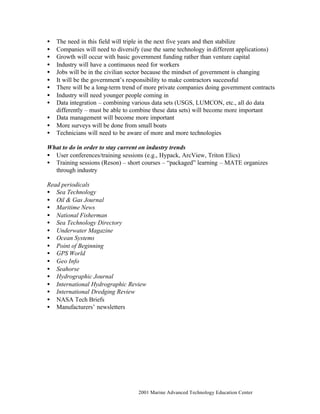
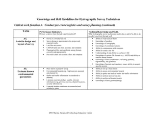
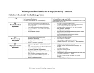
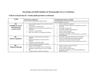
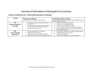
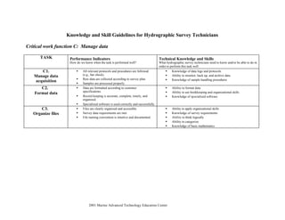
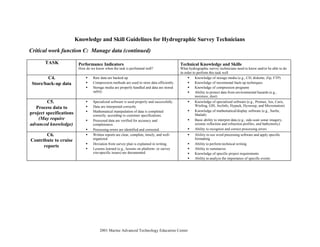
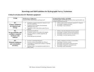
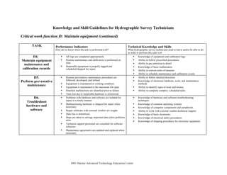
© 2001 Marine Advanced Technology Education Center
KNOWLEDGE AND SKILL GUIDELINES
for
HYDROGRAPHIC SURVEY TECHNICIANS
Introduction to these Guidelines
Like all technicians who work in the marine environment, hydrographic survey technicians
must possess a wide range of knowledge and skills for this growing field. Hydrographic
surveying is important in a variety of marine activities such as mineral resource
management including oil and gas, fishery management, submarine cable routes, marine
archeology, search and recovery efforts, and safe navigation.
Hydrographic survey technicians work long hours – sometimes in stressful situations.
They must learn to use a variety of tools and equipment, ranging from sonar systems to
computers and peripherals, GPS, sampling equipment, and deck equipment.
Individuals who do the same general job functions may have a range of quite different
titles. These may include survey technician, surveyor, survey party chief, physical scientist
technician, geophysical operator, sonar supervisor, or field engineering aide.
The wide scope of educational courses desired or required reflect the depth of knowledge
and skills expected of this position. These courses include oceanography, physics,
computer skills, navigation, marine mechanics, geophysical surveying (including
echosounders, sub-bottom profiling, etc.), and underwater acoustics.
The work of a hydrographic survey technician can be broken down into four main job
functions: conducting pre-cruise logistics and survey planning, conducting field
operations, managing data, and maintaining equipment. Within each of these categories
there are a series of varied tasks that must be performed. For example, conducting field
operations involves everything from troubleshooting field equipment to deploying
equipment to maintaining field logs. In another example, managing data involves
formatting and organizing data as well as contributing to cruise reports.
Personal characteristics of a hydrographic survey technician
The workshop participants who helped develop these Knowledge and Skill Guidelines felt
that the following personal characteristics described a good hydrographic survey
technician:
• Tolerant of seasickness
• Able/willing to be away from home for extended periods of time
• Willing to live in Spartan living conditions
• Skilled at interpersonal relationships
• Willing to work long hours
• Flexible
© 2001 Marine Advanced Technology Education Center
• Able to deal with stress
• Physically fit for work at sea
• Aware of safety issues
• Skilled at solving problems
• Able to make decisions
• Willing to relocate
• Able to manage personal life – families, family obligations
Tools and equipment typically used
• Side-scan sonar
• Multibeam sonar
• Echosounders
• Motion compensators
• Gyrocompass
• Computers and peripherals (plotters)
• Data acquisition systems
• Global positioning systems (GPS)
• Acoustic positioning systems
• Hand tools
• Deck equipment
• High-pressure air compressors
• Sound velocity profilers
• Power supplies (up to 400 volts AC)
• Hydraulics
• ROVs
• Bottom samplers
• Core samplers
• Marine radios
• Winches
• Wheelhouse equipment (radar)
• Still, video, and digital camera equipment
• Fiber optics
• Telemetry systems
• Land-based survey equipment
• SCUBA
Job titles
Entry Level:
Survey technician
Assistant survey technician
Surveyor
Geology technician
© 2001 Marine Advanced Technology Education Center
Electronics technician
Marine technician
Hydrographic technician
Physical scientist technician
Geophysical technician
Physical science aide
Geophysical operator
Field engineering aide
Ocean technician
Technician
Experienced:
Supervisor
Civil engineering technician
Researcher
Sonar supervisor
Lead electronics technician
Senior survey technician
Hydrographer/oceanographer
Survey party chief
Basic courses desired or required
• Oceanography
• Geology
• Physics
• Basic statistics (mean, standard deviation)
• Computer skills (e.g., C++ or Visual Basic, MATLAB, NT, Excel, word processing,
CAD, 3D computer programs, scripting language, GIS, the Internet)
• Creating a display of the product
• Algebra, trigonometry, and geometry (not calculus)
• Electronics (AC/DC, digital)
• Navigation (“rules of the road”)
• Piloting
• Marine mechanics – mechanical skills
• Basic course in conventional surveying (basic mapping and surveying – land surveys)
• Geophysical surveys (seismic) – echosounders, sub-bottom profiling, handling cores,
coring, bottom grabs
• Underwater acoustics
Future trends
• Continuing education will be increasingly important, especially computers
• There will be an increase in remote sensing techniques (e.g., LIDAR)
© 2001 Marine Advanced Technology Education Center
• The need in this field will triple in the next five years and then stabilize
• Companies will need to diversify (use the same technology in different applications)
• Growth will occur with basic government funding rather than venture capital
• Industry will have a continuous need for workers
• Jobs will be in the civilian sector because the mindset of government is changing
• It will be the government’s responsibility to make contractors successful
• There will be a long-term trend of more private companies doing government contracts
• Industry will need younger people coming in
• Data integration – combining various data sets (USGS, LUMCON, etc., all do data
differently – must be able to combine these data sets) will become more important
• Data management will become more important
• More surveys will be done from small boats
• Technicians will need to be aware of more and more technologies
What to do in order to stay current on industry trends
• User conferences/training sessions (e.g., Hypack, ArcView, Triton Elics)
• Training sessions (Reson) – short courses – “packaged” learning – MATE organizes
through industry
Read periodicals
• Sea Technology
• Oil & Gas Journal
• Maritime News
• National Fisherman
• Sea Technology Directory
• Underwater Magazine
• Ocean Systems
• Point of Beginning
• GPS World
• Geo Info
• Seahorse
• Hydrographic Journal
• International Hydrographic Review
• International Dredging Review
• NASA Tech Briefs
• Manufacturers’ newsletters
© 2001 Marine Advanced Technology Education Center
Knowledge and Skill Guidelines for Hydrographic Survey Technicians
Workshop Participant List
Workshop Coordinators: Deidre Sullivan, Alfred Hochstaedter
Workshop Facilitator: Claire Denise
Workshop Recorder: Jill Zande
Workshop Date: March 1, 1999
Panel of Hydrographic Survey Technicians
Judy Boughner Evans-Hamilton, Inc., Seattle, WA
Lloyd Huff NOAA – Office of Coastal Survey, Silver Spring, MD
Pat Iampietro California State University Monterey Bay, Seaside, CA
Bervin Jenkins Oceaneering International, Upper Marlboro, MD
Dale Liebenthal Ohio Department of Natural Resources, Sandusky, OH
Kelly Maccarone U.S. Army Corps of Engineers, Buffalo, NY
Jennifer McCullogh C & C Technologies, Lafayette, LA
David R. Nichols US Geological Survey, Woods Hole, MA
John Snyder Port of Los Angeles, San Pedro, CA
Terry Sullivan Sea Visual Consulting, Inc., Gresham, OR
Jerry Wilson Racal Pelagos Inc., San Diego, CA
David Witmer U.S. Army Corps of Engineers, Buffalo, NY
© 2001 Marine Advanced Technology Education Center
Knowledge and Skill Overview Chart for Hydrographic Survey Technicians
Job description: To assist with logistics, data acquisition, recording, imaging, and processing of various physical parameters relating to
applications in the marine environment.
JOB FUNCTIONS TASK AREAS
A.
Conduct pre-cruise
logistics and survey
planning
A1
Obtain
required
equipment
A2
Assist in
vessel audit
A3
Evaluate
power
requirements
A4
Assist in
design and
layout of
survey
A5
Evaluate
known
environmental
parameters
B.
Conduct field
operations
B1
Troubleshoot
field
equipment
B2
Provide
survey
navigation
B3
Deploy and
recover
equipment
B4
Establish or
recover
horizontal and
vertical
control
B5
Operate
equipment
B6
Maintain field
logs
B7
Maintain
quality of
raw data
B8
Assist with
ship
operations
C.
Manage data
C1
Manage data
acquisition
C2
Format data
C3
Organize files
C4
Store/back up
data
C5
Process data to
project
specifications
C6
Contribute to
cruise reports
D.
Maintain equipment
D1
Prepare
equipment for
shipment and
storage
D2
Set up,
maintain, and
configure
computer
hardware and
software
D3
Maintain
equipment
and
consumables
inventory
D4
Maintain
equipment
maintenance
and
calibration
records
D5
Perform
preventative
maintenance
D6
Troubleshoot
hardware and
software
© 2001 Marine Advanced Technology Education Center
Knowledge and Skill Guidelines for Hydrographic Survey Technicians
Critical work function A: Conduct pre-cruise logistics and survey planning
TASK Performance Indicators
How do we know when the task is performed well?
Technical Knowledge and Skills
What hydrographic survey technicians need to know and/or be able to do
in order to perform this task well
A1.
Obtain required
equipment
• Appropriate equipment is procured.
• Equipment is ready and available for use.
• Required equipment is aboard work platform in
working order well in advance of survey.
• Equipment is secured for at-sea conditions.
• Ability to select appropriate equipment for a specific job
• Ability to check and calibrate equipment prior to shipment
• Ability to prepare equipment for shipment
• Ability to install and test equipment aboard survey platform
• Ability to store equipment properly/secure equipment before
and after use
• Knowledge of methods for securing sensitive equipment for
sea
A2.
Assist in vessel audit
• All safety guidelines, including Coast Guard standards,
are met.
• Equipment is properly handled aboard ship.
• Ship capacities are not exceeded.
• Vessel acoustics are evaluated and considered
appropriately.
• Platform-specific considerations are appropriately
planned for.
• Knowledge of pertinent safety guidelines
• Knowledge of equipment ergonomics
• Knowledge of equipment space requirements
• Knowledge of berthing capacity
• Knowledge of basic marine architecture and ship capacities
• Knowledge of potential vessel acoustic effects on survey
• Ability to select equipment appropriate to the platform at hand.
A3.
Evaluate power
requirements
• Power requirements for specific projects are correctly
planned for and met.
• Electrical power requirements are evaluated completely
and correctly.
• Power requirements/adjustments are coordinated with
shipboard personnel.
• Safety is maintained at all times.
• Knowledge of basic electricity, electronics, power systems,
and wiring
• Knowledge of international wiring and power standards
• Knowledge of power requirements for a specific project,
including knowledge of ship’s power
• Ability to understand instruction manuals and diagrams.
• Knowledge of safety requirements (e.g., ground fault
protection)
© 2001 Marine Advanced Technology Education Center
Knowledge and Skill Guidelines for Hydrographic Survey Technicians
Critical work function A: Conduct pre-cruise logistics and survey planning (continued)
TASK Performance Indicators
How do we know when the task is performed well?
Technical Knowledge and Skills
What hydrographic survey technicians need to know and/or be able to do
in order to perform this task well
A4.
Assist in design and
layout of survey
• Survey is correctly laid out.
• Survey design is appropriate to the project and
expected results.
• Line files are correct.
• CAD/GIS plots are clear, accurate, and complete.
• Planning/test files are transferred among formats
correctly and appropriately.
• Pre-cruise charts are accurate, clear, and complete.
• Ability to read nautical charts
• Knowledge of geodesy
• Knowledge of cartography
• Knowledge of coordinate systems
• Ability to communicate with customer
• Ability to create a line file
• Understanding of and ability to use basic CAD
• Knowledge of various file formats (e.g., ASCII) and ability to
transfer among formats
• Knowledge of basic mathematics, including geometry,
trigonometry, and geomatics
• Knowledge of permits and regulatory issues; ability to acquire
specific permits
A5.
Evaluate known
environmental
parameters
• Base station is properly set up.
• Environmental hazards (e.g., high seas) are assessed
and planned for.
• Harbor and traffic information is considered in
planning.
• Literature searches produce useable, relevant
information (e.g., previous surveys, channel locations,
acoustic information).
• Expected weather conditions are researched and
included in plans.
• Ability to set up a base station
• Ability to assess environmental hazards
• Ability to gather and analyze harbor and traffic information
• Ability to analyze past survey data
• Ability to perform a literature search
• Knowledge of basic geomorphology
© 2001 Marine Advanced Technology Education Center
Knowledge and Skill Guidelines for Hydrographic Survey Technicians
Critical work function B: Conduct field operations
TASK Performance Indicators
How do we know when the task is performed well?
Technical Knowledge and Skills
What hydrographic survey technicians need to know and/or be able to do in
order to perform this task well
B1.
Troubleshoot field
equipment
• Equipment functions properly throughout survey.
• Ready supply of back-up components is maintained
on survey platform.
• Time lost due to equipment outage is minimized.
• Gauges and indicators are checked periodically for
accuracy.
• Accurate data are collected.
• Knowledge of troubleshooting techniques
• Knowledge of and ability to use computer operating systems,
networks, and specialized software efficiently
• Knowledge of basic electronics (e.g., AC and DC circuitry,
digital electronics, fiber optics)
• Knowledge of basic hydraulics
• Ability to contact and communicate well with technical support
• Ability to integrate equipment
• Ability to read schematics and instruction manuals
• Ability to maintain spares inventory
B2.
Provide survey
navigation
• Survey navigation is delivered correctly,
appropriately, and on time.
• Navigation systems interface is appropriate and used
correctly.
• Hazards to navigation are identified.
• Knowledge of navigation systems
• Understanding of ship handling
• Understanding of navigation system interfaces
• Knowledge of local area – local terrain (e.g., shoals, pinnacles)
B3.
Deploy and recover
equipment
• Equipment is appropriately handled while onboard
ship.
• Crane and boom operations are efficient and safe and
result in no equipment damage.
• All deployed sensors are recovered safely.
• Cutting and welding is completed to project needs and
specifications.
• Safety procedures are followed and no unsafe
practices or accidents result from deployment and
recovery.
• Survey is completed efficiently.
• Ability to use survey equipment correctly
• Knowledge of crane and boom equipment, operation, and
procedures
• Knowledge of hand signals
• Ability to use mechanical tools
• Ability to cut and weld
• Understanding of and ability to implement safety and health rules
in accordance with permits (e.g., OSHA)
• Knowledge of proper storage, packaging, and shipping
procedures
• Knowledge of shipboard layouts
© 2001 Marine Advanced Technology Education Center
Knowledge and Skill Guidelines for Hydrographic Survey Technicians
Critical work function B: Conduct field operations (continued)
TASK Performance Indicators
How do we know when the task is performed well?
Technical Knowledge and Skills
What hydrographic survey technicians need to know and/or be able to do in
order to perform this task well
B4.
Establish or recover
horizontal and
vertical control
• Survey and GPS equipment is used correctly to obtain
desired results.
• Tide gauges are installed properly.
• Database queries are relevant to the need and provide
useful data.
• Elevation is assessed properly.
• Pitch, roll, and heave are compensated and filtered.
• Ability to operate GPS equipment
• Knowledge of traditional land survey equipment (e.g., transits
and levels)
• Knowledge of geodesy/GIS
• Knowledge of multiple mapping data sets
• Ability to install tide gauges
• Ability to perform database queries
• Knowledge of and ability to use the Internet (e.g., search NGS,
NIMA databases)
B5.
Operate equipment
• Equipment is operated safely and according to
guidelines.
• Equipment performance is monitored while in
operation.
• Equipment is inspected frequently.
• Equipment produces high quality survey data.
• Knowledge of operational characteristics of equipment
• Ability to read and understand operating instructions
• Knowledge of data quality assurance thresholds
• Ability to assess the effects of vessel acoustics on survey data
B6.
Maintain field logs
• Logs are maintained properly.
• Writing is clear, complete, concise, and sequential.
• Appropriate computer formats are used to maintain
logs.
• Computerized logs are backed up frequently.
• Ability to write clear, concise log entries
• Ability to annotate records
• Ability to follow accepted formats
• Knowledge of and ability to use common spreadsheets and
database programs
© 2001 Marine Advanced Technology Education Center
Knowledge and Skill Guidelines for Hydrographic Survey Technicians
Critical work function B: Conduct field operations (continued)
TASK Performance Indicators
How do we know when the task is performed well?
Technical Knowledge and Skills
What hydrographic survey technicians need to know and/or be able to do
in order to perform this task well
B7.
Maintain quality of
raw data
• Prescribed procedures are followed and attention is
paid to detail.
• Raw data are monitored continuously; modifications
are made when data stray from acceptable limits.
• Appropriate data format is used.
• Ability to follow prescribed procedures
• Ability to work in multiple data formats
• Understanding of the intended use of data
• Ability to recognize data relevant to specific job parameters
• Ability to identify and take corrective action when data stray
from acceptable thresholds
B8.
Assist with ship
operations
• Basic seamanship practices are followed.
• Shipboard safety is maintained.
• Small boats are employed safely and efficiently.
• Appropriate responses are made to changing situations.
• Knowledge of seamanship, basic rigging, and deck equipment
• Knowledge of ship safety procedures
• Ability to pilot small boats
• Ability to assess changes in environmental conditions
© 2001 Marine Advanced Technology Education Center
Knowledge and Skill Guidelines for Hydrographic Survey Technicians
Critical work function C: Manage data
TASK Performance Indicators
How do we know when the task is performed well?
Technical Knowledge and Skills
What hydrographic survey technicians need to know and/or be able to do in
order to perform this task well
C1.
Manage data
acquisition
• All relevant protocols and procedures are followed
(e.g., bar check).
• Raw data are collected according to survey plan.
• Samples are processed properly.
• Knowledge of data logs and protocols
• Ability to monitor, back up, and archive data
• Knowledge of sample handling procedures
C2.
Format data
• Data are formatted according to customer
specifications.
• Record keeping is accurate, complete, timely, and
organized.
• Specialized software is used correctly and successfully.
• Ability to format data
• Ability to use bookkeeping and organizational skills
• Knowledge of specialized software
C3.
Organize files
• Files are clearly organized and accessible.
• Survey data requirements are met.
• File naming convention is intuitive and documented.
• Ability to apply organizational skills
• Knowledge of survey requirements
• Ability to think logically
• Ability to categorize
• Knowledge of basic mathematics
© 2001 Marine Advanced Technology Education Center
Knowledge and Skill Guidelines for Hydrographic Survey Technicians
Critical work function C: Manage data (continued)
TASK Performance Indicators
How do we know when the task is performed well?
Technical Knowledge and Skills
What hydrographic survey technicians need to know and/or be able to do
in order to perform this task well
C4.
Store/back-up data
• Raw data are backed up.
• Compression methods are used to store data efficiently.
• Storage media are properly handled and data are stored
safely.
• Knowledge of storage media (e.g., CD, diskette, Zip, FTP)
• Knowledge of incremental back-up techniques
• Knowledge of compression programs
• Ability to protect data from environmental hazards (e.g.,
moisture, dust)
C5.
Process data to
project specifications
(May require
advanced knowledge)
• Specialized software is used properly and successfully.
• Data are interpreted correctly.
• Mathematical manipulation of data is completed
correctly, according to customer specifications.
• Processed data are verified for accuracy and
completeness.
• Processing errors are identified and corrected.
• Knowledge of specialized software (e.g., Promax, Isis, Caris,
Winfrog, GIS, ArcInfo, Hypack, Hysweep, and Microstation)
• Knowledge of mathematical/display software (e.g., Surfer,
Matlab)
• Basic ability to interpret data (e.g., side-scan sonar imagery,
seismic reflection and refraction profiles, and bathymetry)
• Ability to recognize and correct processing errors
C6.
Contribute to cruise
reports
• Written reports are clear, complete, timely, and well-
organized.
• Deviation from survey plan is explained in writing.
• Lessons learned (e.g., lessons on platform- or survey
site-specific issues) are documented.
• Ability to use word processing software and apply specific
formatting
• Ability to perform technical writing
• Ability to summarize
• Knowledge of specific project requirements
• Ability to analyze the importance of specific events
© 2001 Marine Advanced Technology Education Center
Knowledge and Skill Guidelines for Hydrographic Survey Technicians
Critical work function D: Maintain equipment
TASK Performance Indicators
How do we know when the task is performed well?
Technical Knowledge and Skills
What hydrographic survey technicians need to know and/or be able to do
in order to perform this task well
D1.
Prepare equipment
for shipment and
storage
• Equipment is properly prepared for shipment to and
from job site/platform.
• Equipment arrives at/departs from destination
undamaged and on time.
• Equipment is safely crane-lifted on and off survey
platform.
• Ability to pack sensitive electronic equipment for shipment
• Knowledge of shipping procedures
• Knowledge of crane operations
D2.
Set up, maintain, and
configure computer
hardware and
software
• Instructions are followed.
• Peripherals interface successfully with computer.
• Necessary software is installed, upgraded, and
uninstalled.
• System back-ups are performed.
• Ability to read and understand instruction manuals
• Knowledge of computer hardware and peripherals
• Knowledge of Internet protocols and connectivity
• Knowledge of common operating systems
D3.
Maintain equipment
and consumables
inventory
• Inventory is maintained adequately.
• Inventory systems and procedures are followed.
• Consumables are ordered well in advance of reaching
critical shortages.
• Ordering of parts is accomplished smoothly and in a
timely manner.
• Ability to maintain an inventory of consumables
• Knowledge of inventory systems
• Knowledge of procurement systems/procedures
• Knowledge of equipment consumption rates
• Knowledge of part nomenclature
© 2001 Marine Advanced Technology Education Center
Knowledge and Skill Guidelines for Hydrographic Survey Technicians
Critical work function D: Maintain equipment (continued)
TASK Performance Indicators
How do we know when the task is performed well?
Technical Knowledge and Skills
What hydrographic survey technicians need to know and/or be able to do
in order to perform this task well
D4.
Maintain equipment
maintenance and
calibration records
• All logs are completed appropriately.
• Routine maintenance and calibration is performed on
time.
• Inoperable equipment is properly tagged and
scheduled/shipped for repair.
• Knowledge of equipment and calibration logs
• Ability to follow prescribed procedures
• Ability to pay attention to detail
• Knowledge of basic mathematics
• Ability to convert units of measure
• Ability to schedule maintenance and calibration events
D5.
Perform preventative
maintenance
• Routine preventative maintenance procedures are
followed, developed, and refined.
• Equipment is maintained in working condition.
• Equipment is maintained to the maximum life span.
• Potential malfunctions are identified prior to failure.
• Time lost due to inoperable hardware is minimized.
• Ability to follow detailed directions
• Knowledge of electronic hardware, tools, and maintenance
methods
• Ability to identify signs of wear and misuse
• Ability to complete complex, scheduled tasks
D6.
Troubleshoot
hardware and
software
• Problems with hardware and software are isolated for
repair in a timely manner.
• Malfunctioning hardware is shipped for repair when
necessary.
• Repair solutions with external vendors are sought.
• Data loss is minimized.
• Steps are taken to salvage important data when problems
arise.
• Technical support personnel are consulted for software
solutions.
• Maintenance agreements are updated and replaced when
necessary.
• Knowledge of hardware and software troubleshooting
techniques
• Knowledge of common operating systems
• Knowledge of computer components and peripherals
• Ability to work with external vendors/technical support
• Knowledge of basic electronics
• Knowledge of electrical safety procedures
• Knowledge of shipping procedures for electronic equipment

Hydrographic Survey Technicians

  • 1.
    © 2001 MarineAdvanced Technology Education Center KNOWLEDGE AND SKILL GUIDELINES for HYDROGRAPHIC SURVEY TECHNICIANS Introduction to these Guidelines Like all technicians who work in the marine environment, hydrographic survey technicians must possess a wide range of knowledge and skills for this growing field. Hydrographic surveying is important in a variety of marine activities such as mineral resource management including oil and gas, fishery management, submarine cable routes, marine archeology, search and recovery efforts, and safe navigation. Hydrographic survey technicians work long hours – sometimes in stressful situations. They must learn to use a variety of tools and equipment, ranging from sonar systems to computers and peripherals, GPS, sampling equipment, and deck equipment. Individuals who do the same general job functions may have a range of quite different titles. These may include survey technician, surveyor, survey party chief, physical scientist technician, geophysical operator, sonar supervisor, or field engineering aide. The wide scope of educational courses desired or required reflect the depth of knowledge and skills expected of this position. These courses include oceanography, physics, computer skills, navigation, marine mechanics, geophysical surveying (including echosounders, sub-bottom profiling, etc.), and underwater acoustics. The work of a hydrographic survey technician can be broken down into four main job functions: conducting pre-cruise logistics and survey planning, conducting field operations, managing data, and maintaining equipment. Within each of these categories there are a series of varied tasks that must be performed. For example, conducting field operations involves everything from troubleshooting field equipment to deploying equipment to maintaining field logs. In another example, managing data involves formatting and organizing data as well as contributing to cruise reports. Personal characteristics of a hydrographic survey technician The workshop participants who helped develop these Knowledge and Skill Guidelines felt that the following personal characteristics described a good hydrographic survey technician: • Tolerant of seasickness • Able/willing to be away from home for extended periods of time • Willing to live in Spartan living conditions • Skilled at interpersonal relationships • Willing to work long hours • Flexible
  • 2.
    © 2001 MarineAdvanced Technology Education Center • Able to deal with stress • Physically fit for work at sea • Aware of safety issues • Skilled at solving problems • Able to make decisions • Willing to relocate • Able to manage personal life – families, family obligations Tools and equipment typically used • Side-scan sonar • Multibeam sonar • Echosounders • Motion compensators • Gyrocompass • Computers and peripherals (plotters) • Data acquisition systems • Global positioning systems (GPS) • Acoustic positioning systems • Hand tools • Deck equipment • High-pressure air compressors • Sound velocity profilers • Power supplies (up to 400 volts AC) • Hydraulics • ROVs • Bottom samplers • Core samplers • Marine radios • Winches • Wheelhouse equipment (radar) • Still, video, and digital camera equipment • Fiber optics • Telemetry systems • Land-based survey equipment • SCUBA Job titles Entry Level: Survey technician Assistant survey technician Surveyor Geology technician
  • 3.
    © 2001 MarineAdvanced Technology Education Center Electronics technician Marine technician Hydrographic technician Physical scientist technician Geophysical technician Physical science aide Geophysical operator Field engineering aide Ocean technician Technician Experienced: Supervisor Civil engineering technician Researcher Sonar supervisor Lead electronics technician Senior survey technician Hydrographer/oceanographer Survey party chief Basic courses desired or required • Oceanography • Geology • Physics • Basic statistics (mean, standard deviation) • Computer skills (e.g., C++ or Visual Basic, MATLAB, NT, Excel, word processing, CAD, 3D computer programs, scripting language, GIS, the Internet) • Creating a display of the product • Algebra, trigonometry, and geometry (not calculus) • Electronics (AC/DC, digital) • Navigation (“rules of the road”) • Piloting • Marine mechanics – mechanical skills • Basic course in conventional surveying (basic mapping and surveying – land surveys) • Geophysical surveys (seismic) – echosounders, sub-bottom profiling, handling cores, coring, bottom grabs • Underwater acoustics Future trends • Continuing education will be increasingly important, especially computers • There will be an increase in remote sensing techniques (e.g., LIDAR)
  • 4.
    © 2001 MarineAdvanced Technology Education Center • The need in this field will triple in the next five years and then stabilize • Companies will need to diversify (use the same technology in different applications) • Growth will occur with basic government funding rather than venture capital • Industry will have a continuous need for workers • Jobs will be in the civilian sector because the mindset of government is changing • It will be the government’s responsibility to make contractors successful • There will be a long-term trend of more private companies doing government contracts • Industry will need younger people coming in • Data integration – combining various data sets (USGS, LUMCON, etc., all do data differently – must be able to combine these data sets) will become more important • Data management will become more important • More surveys will be done from small boats • Technicians will need to be aware of more and more technologies What to do in order to stay current on industry trends • User conferences/training sessions (e.g., Hypack, ArcView, Triton Elics) • Training sessions (Reson) – short courses – “packaged” learning – MATE organizes through industry Read periodicals • Sea Technology • Oil & Gas Journal • Maritime News • National Fisherman • Sea Technology Directory • Underwater Magazine • Ocean Systems • Point of Beginning • GPS World • Geo Info • Seahorse • Hydrographic Journal • International Hydrographic Review • International Dredging Review • NASA Tech Briefs • Manufacturers’ newsletters
  • 5.
    © 2001 MarineAdvanced Technology Education Center Knowledge and Skill Guidelines for Hydrographic Survey Technicians Workshop Participant List Workshop Coordinators: Deidre Sullivan, Alfred Hochstaedter Workshop Facilitator: Claire Denise Workshop Recorder: Jill Zande Workshop Date: March 1, 1999 Panel of Hydrographic Survey Technicians Judy Boughner Evans-Hamilton, Inc., Seattle, WA Lloyd Huff NOAA – Office of Coastal Survey, Silver Spring, MD Pat Iampietro California State University Monterey Bay, Seaside, CA Bervin Jenkins Oceaneering International, Upper Marlboro, MD Dale Liebenthal Ohio Department of Natural Resources, Sandusky, OH Kelly Maccarone U.S. Army Corps of Engineers, Buffalo, NY Jennifer McCullogh C & C Technologies, Lafayette, LA David R. Nichols US Geological Survey, Woods Hole, MA John Snyder Port of Los Angeles, San Pedro, CA Terry Sullivan Sea Visual Consulting, Inc., Gresham, OR Jerry Wilson Racal Pelagos Inc., San Diego, CA David Witmer U.S. Army Corps of Engineers, Buffalo, NY
  • 6.
    © 2001 MarineAdvanced Technology Education Center Knowledge and Skill Overview Chart for Hydrographic Survey Technicians Job description: To assist with logistics, data acquisition, recording, imaging, and processing of various physical parameters relating to applications in the marine environment. JOB FUNCTIONS TASK AREAS A. Conduct pre-cruise logistics and survey planning A1 Obtain required equipment A2 Assist in vessel audit A3 Evaluate power requirements A4 Assist in design and layout of survey A5 Evaluate known environmental parameters B. Conduct field operations B1 Troubleshoot field equipment B2 Provide survey navigation B3 Deploy and recover equipment B4 Establish or recover horizontal and vertical control B5 Operate equipment B6 Maintain field logs B7 Maintain quality of raw data B8 Assist with ship operations C. Manage data C1 Manage data acquisition C2 Format data C3 Organize files C4 Store/back up data C5 Process data to project specifications C6 Contribute to cruise reports D. Maintain equipment D1 Prepare equipment for shipment and storage D2 Set up, maintain, and configure computer hardware and software D3 Maintain equipment and consumables inventory D4 Maintain equipment maintenance and calibration records D5 Perform preventative maintenance D6 Troubleshoot hardware and software
  • 7.
    © 2001 MarineAdvanced Technology Education Center Knowledge and Skill Guidelines for Hydrographic Survey Technicians Critical work function A: Conduct pre-cruise logistics and survey planning TASK Performance Indicators How do we know when the task is performed well? Technical Knowledge and Skills What hydrographic survey technicians need to know and/or be able to do in order to perform this task well A1. Obtain required equipment • Appropriate equipment is procured. • Equipment is ready and available for use. • Required equipment is aboard work platform in working order well in advance of survey. • Equipment is secured for at-sea conditions. • Ability to select appropriate equipment for a specific job • Ability to check and calibrate equipment prior to shipment • Ability to prepare equipment for shipment • Ability to install and test equipment aboard survey platform • Ability to store equipment properly/secure equipment before and after use • Knowledge of methods for securing sensitive equipment for sea A2. Assist in vessel audit • All safety guidelines, including Coast Guard standards, are met. • Equipment is properly handled aboard ship. • Ship capacities are not exceeded. • Vessel acoustics are evaluated and considered appropriately. • Platform-specific considerations are appropriately planned for. • Knowledge of pertinent safety guidelines • Knowledge of equipment ergonomics • Knowledge of equipment space requirements • Knowledge of berthing capacity • Knowledge of basic marine architecture and ship capacities • Knowledge of potential vessel acoustic effects on survey • Ability to select equipment appropriate to the platform at hand. A3. Evaluate power requirements • Power requirements for specific projects are correctly planned for and met. • Electrical power requirements are evaluated completely and correctly. • Power requirements/adjustments are coordinated with shipboard personnel. • Safety is maintained at all times. • Knowledge of basic electricity, electronics, power systems, and wiring • Knowledge of international wiring and power standards • Knowledge of power requirements for a specific project, including knowledge of ship’s power • Ability to understand instruction manuals and diagrams. • Knowledge of safety requirements (e.g., ground fault protection)
  • 8.
    © 2001 MarineAdvanced Technology Education Center Knowledge and Skill Guidelines for Hydrographic Survey Technicians Critical work function A: Conduct pre-cruise logistics and survey planning (continued) TASK Performance Indicators How do we know when the task is performed well? Technical Knowledge and Skills What hydrographic survey technicians need to know and/or be able to do in order to perform this task well A4. Assist in design and layout of survey • Survey is correctly laid out. • Survey design is appropriate to the project and expected results. • Line files are correct. • CAD/GIS plots are clear, accurate, and complete. • Planning/test files are transferred among formats correctly and appropriately. • Pre-cruise charts are accurate, clear, and complete. • Ability to read nautical charts • Knowledge of geodesy • Knowledge of cartography • Knowledge of coordinate systems • Ability to communicate with customer • Ability to create a line file • Understanding of and ability to use basic CAD • Knowledge of various file formats (e.g., ASCII) and ability to transfer among formats • Knowledge of basic mathematics, including geometry, trigonometry, and geomatics • Knowledge of permits and regulatory issues; ability to acquire specific permits A5. Evaluate known environmental parameters • Base station is properly set up. • Environmental hazards (e.g., high seas) are assessed and planned for. • Harbor and traffic information is considered in planning. • Literature searches produce useable, relevant information (e.g., previous surveys, channel locations, acoustic information). • Expected weather conditions are researched and included in plans. • Ability to set up a base station • Ability to assess environmental hazards • Ability to gather and analyze harbor and traffic information • Ability to analyze past survey data • Ability to perform a literature search • Knowledge of basic geomorphology
  • 9.
    © 2001 MarineAdvanced Technology Education Center Knowledge and Skill Guidelines for Hydrographic Survey Technicians Critical work function B: Conduct field operations TASK Performance Indicators How do we know when the task is performed well? Technical Knowledge and Skills What hydrographic survey technicians need to know and/or be able to do in order to perform this task well B1. Troubleshoot field equipment • Equipment functions properly throughout survey. • Ready supply of back-up components is maintained on survey platform. • Time lost due to equipment outage is minimized. • Gauges and indicators are checked periodically for accuracy. • Accurate data are collected. • Knowledge of troubleshooting techniques • Knowledge of and ability to use computer operating systems, networks, and specialized software efficiently • Knowledge of basic electronics (e.g., AC and DC circuitry, digital electronics, fiber optics) • Knowledge of basic hydraulics • Ability to contact and communicate well with technical support • Ability to integrate equipment • Ability to read schematics and instruction manuals • Ability to maintain spares inventory B2. Provide survey navigation • Survey navigation is delivered correctly, appropriately, and on time. • Navigation systems interface is appropriate and used correctly. • Hazards to navigation are identified. • Knowledge of navigation systems • Understanding of ship handling • Understanding of navigation system interfaces • Knowledge of local area – local terrain (e.g., shoals, pinnacles) B3. Deploy and recover equipment • Equipment is appropriately handled while onboard ship. • Crane and boom operations are efficient and safe and result in no equipment damage. • All deployed sensors are recovered safely. • Cutting and welding is completed to project needs and specifications. • Safety procedures are followed and no unsafe practices or accidents result from deployment and recovery. • Survey is completed efficiently. • Ability to use survey equipment correctly • Knowledge of crane and boom equipment, operation, and procedures • Knowledge of hand signals • Ability to use mechanical tools • Ability to cut and weld • Understanding of and ability to implement safety and health rules in accordance with permits (e.g., OSHA) • Knowledge of proper storage, packaging, and shipping procedures • Knowledge of shipboard layouts
  • 10.
    © 2001 MarineAdvanced Technology Education Center Knowledge and Skill Guidelines for Hydrographic Survey Technicians Critical work function B: Conduct field operations (continued) TASK Performance Indicators How do we know when the task is performed well? Technical Knowledge and Skills What hydrographic survey technicians need to know and/or be able to do in order to perform this task well B4. Establish or recover horizontal and vertical control • Survey and GPS equipment is used correctly to obtain desired results. • Tide gauges are installed properly. • Database queries are relevant to the need and provide useful data. • Elevation is assessed properly. • Pitch, roll, and heave are compensated and filtered. • Ability to operate GPS equipment • Knowledge of traditional land survey equipment (e.g., transits and levels) • Knowledge of geodesy/GIS • Knowledge of multiple mapping data sets • Ability to install tide gauges • Ability to perform database queries • Knowledge of and ability to use the Internet (e.g., search NGS, NIMA databases) B5. Operate equipment • Equipment is operated safely and according to guidelines. • Equipment performance is monitored while in operation. • Equipment is inspected frequently. • Equipment produces high quality survey data. • Knowledge of operational characteristics of equipment • Ability to read and understand operating instructions • Knowledge of data quality assurance thresholds • Ability to assess the effects of vessel acoustics on survey data B6. Maintain field logs • Logs are maintained properly. • Writing is clear, complete, concise, and sequential. • Appropriate computer formats are used to maintain logs. • Computerized logs are backed up frequently. • Ability to write clear, concise log entries • Ability to annotate records • Ability to follow accepted formats • Knowledge of and ability to use common spreadsheets and database programs
  • 11.
    © 2001 MarineAdvanced Technology Education Center Knowledge and Skill Guidelines for Hydrographic Survey Technicians Critical work function B: Conduct field operations (continued) TASK Performance Indicators How do we know when the task is performed well? Technical Knowledge and Skills What hydrographic survey technicians need to know and/or be able to do in order to perform this task well B7. Maintain quality of raw data • Prescribed procedures are followed and attention is paid to detail. • Raw data are monitored continuously; modifications are made when data stray from acceptable limits. • Appropriate data format is used. • Ability to follow prescribed procedures • Ability to work in multiple data formats • Understanding of the intended use of data • Ability to recognize data relevant to specific job parameters • Ability to identify and take corrective action when data stray from acceptable thresholds B8. Assist with ship operations • Basic seamanship practices are followed. • Shipboard safety is maintained. • Small boats are employed safely and efficiently. • Appropriate responses are made to changing situations. • Knowledge of seamanship, basic rigging, and deck equipment • Knowledge of ship safety procedures • Ability to pilot small boats • Ability to assess changes in environmental conditions
  • 12.
    © 2001 MarineAdvanced Technology Education Center Knowledge and Skill Guidelines for Hydrographic Survey Technicians Critical work function C: Manage data TASK Performance Indicators How do we know when the task is performed well? Technical Knowledge and Skills What hydrographic survey technicians need to know and/or be able to do in order to perform this task well C1. Manage data acquisition • All relevant protocols and procedures are followed (e.g., bar check). • Raw data are collected according to survey plan. • Samples are processed properly. • Knowledge of data logs and protocols • Ability to monitor, back up, and archive data • Knowledge of sample handling procedures C2. Format data • Data are formatted according to customer specifications. • Record keeping is accurate, complete, timely, and organized. • Specialized software is used correctly and successfully. • Ability to format data • Ability to use bookkeeping and organizational skills • Knowledge of specialized software C3. Organize files • Files are clearly organized and accessible. • Survey data requirements are met. • File naming convention is intuitive and documented. • Ability to apply organizational skills • Knowledge of survey requirements • Ability to think logically • Ability to categorize • Knowledge of basic mathematics
  • 13.
    © 2001 MarineAdvanced Technology Education Center Knowledge and Skill Guidelines for Hydrographic Survey Technicians Critical work function C: Manage data (continued) TASK Performance Indicators How do we know when the task is performed well? Technical Knowledge and Skills What hydrographic survey technicians need to know and/or be able to do in order to perform this task well C4. Store/back-up data • Raw data are backed up. • Compression methods are used to store data efficiently. • Storage media are properly handled and data are stored safely. • Knowledge of storage media (e.g., CD, diskette, Zip, FTP) • Knowledge of incremental back-up techniques • Knowledge of compression programs • Ability to protect data from environmental hazards (e.g., moisture, dust) C5. Process data to project specifications (May require advanced knowledge) • Specialized software is used properly and successfully. • Data are interpreted correctly. • Mathematical manipulation of data is completed correctly, according to customer specifications. • Processed data are verified for accuracy and completeness. • Processing errors are identified and corrected. • Knowledge of specialized software (e.g., Promax, Isis, Caris, Winfrog, GIS, ArcInfo, Hypack, Hysweep, and Microstation) • Knowledge of mathematical/display software (e.g., Surfer, Matlab) • Basic ability to interpret data (e.g., side-scan sonar imagery, seismic reflection and refraction profiles, and bathymetry) • Ability to recognize and correct processing errors C6. Contribute to cruise reports • Written reports are clear, complete, timely, and well- organized. • Deviation from survey plan is explained in writing. • Lessons learned (e.g., lessons on platform- or survey site-specific issues) are documented. • Ability to use word processing software and apply specific formatting • Ability to perform technical writing • Ability to summarize • Knowledge of specific project requirements • Ability to analyze the importance of specific events
  • 14.
    © 2001 MarineAdvanced Technology Education Center Knowledge and Skill Guidelines for Hydrographic Survey Technicians Critical work function D: Maintain equipment TASK Performance Indicators How do we know when the task is performed well? Technical Knowledge and Skills What hydrographic survey technicians need to know and/or be able to do in order to perform this task well D1. Prepare equipment for shipment and storage • Equipment is properly prepared for shipment to and from job site/platform. • Equipment arrives at/departs from destination undamaged and on time. • Equipment is safely crane-lifted on and off survey platform. • Ability to pack sensitive electronic equipment for shipment • Knowledge of shipping procedures • Knowledge of crane operations D2. Set up, maintain, and configure computer hardware and software • Instructions are followed. • Peripherals interface successfully with computer. • Necessary software is installed, upgraded, and uninstalled. • System back-ups are performed. • Ability to read and understand instruction manuals • Knowledge of computer hardware and peripherals • Knowledge of Internet protocols and connectivity • Knowledge of common operating systems D3. Maintain equipment and consumables inventory • Inventory is maintained adequately. • Inventory systems and procedures are followed. • Consumables are ordered well in advance of reaching critical shortages. • Ordering of parts is accomplished smoothly and in a timely manner. • Ability to maintain an inventory of consumables • Knowledge of inventory systems • Knowledge of procurement systems/procedures • Knowledge of equipment consumption rates • Knowledge of part nomenclature
  • 15.
    © 2001 MarineAdvanced Technology Education Center Knowledge and Skill Guidelines for Hydrographic Survey Technicians Critical work function D: Maintain equipment (continued) TASK Performance Indicators How do we know when the task is performed well? Technical Knowledge and Skills What hydrographic survey technicians need to know and/or be able to do in order to perform this task well D4. Maintain equipment maintenance and calibration records • All logs are completed appropriately. • Routine maintenance and calibration is performed on time. • Inoperable equipment is properly tagged and scheduled/shipped for repair. • Knowledge of equipment and calibration logs • Ability to follow prescribed procedures • Ability to pay attention to detail • Knowledge of basic mathematics • Ability to convert units of measure • Ability to schedule maintenance and calibration events D5. Perform preventative maintenance • Routine preventative maintenance procedures are followed, developed, and refined. • Equipment is maintained in working condition. • Equipment is maintained to the maximum life span. • Potential malfunctions are identified prior to failure. • Time lost due to inoperable hardware is minimized. • Ability to follow detailed directions • Knowledge of electronic hardware, tools, and maintenance methods • Ability to identify signs of wear and misuse • Ability to complete complex, scheduled tasks D6. Troubleshoot hardware and software • Problems with hardware and software are isolated for repair in a timely manner. • Malfunctioning hardware is shipped for repair when necessary. • Repair solutions with external vendors are sought. • Data loss is minimized. • Steps are taken to salvage important data when problems arise. • Technical support personnel are consulted for software solutions. • Maintenance agreements are updated and replaced when necessary. • Knowledge of hardware and software troubleshooting techniques • Knowledge of common operating systems • Knowledge of computer components and peripherals • Ability to work with external vendors/technical support • Knowledge of basic electronics • Knowledge of electrical safety procedures • Knowledge of shipping procedures for electronic equipment