Area Navigation (RNAV) notes 3.docx
•Download as DOCX, PDF•
0 likes•6 views
Area navigation (RNAV) allows aircraft to navigate from point A to point B without directly overflying navigational aids like VOR stations or NDBs. It uses waypoints defined by latitude/longitude or as a radial and distance from a VOR to create a more direct flight route. On a VOR-based RNAV system, the RNAV computer uses the aircraft's VOR receiver and CDI to calculate headings, speeds, and times to fly between each waypoint, displayed as phantom stations on the CDI. This allows aircraft to navigate a direct path between locations rather than following a less efficient route connecting individual navigational aids.
Report
Share
Report
Share
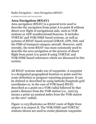
![that are overflown rather than the actual stations. This
allows a more direct route to be taken. The phantom
waypoints are entered into the RNAV course-line
computer (CLC) as a radial and distance number pair.
The computer creates the waypoints and causes the
aircraft’s CDI to operate as though they are actual VOR
stations. A mode switch allows the choice between
standard VOR navigation and RNAV.
Figure 11-123. The pilot uses the aircraft’s course deviation
indicator to fly to and from RNAV phantom waypoints created
by computer. This allows direct routes to be created and flown
rather than flying from VOR to VOR. [click image to enlarge]
VOR based RNAV uses the VOR receiver, antenna, and
VOR display equipment, such as the CDI. The computer
in the RNAV unit uses basic geometry and
trigonometry calculations to produce heading, speed,](data:image/gif;base64,R0lGODlhAQABAIAAAAAAAP///yH5BAEAAAAALAAAAAABAAEAAAIBRAA7)
Recommended
AREA NAVVIGATION.pptx
Area navigation (RNAV) allows aircraft to fly any desired flight path within the coverage area of ground-based navigation aids or satellite navigation. It involves using navigation sensors like VOR, DME, and satellite systems to determine the aircraft's position and define waypoints not located at navigation aids. The main components of an RNAV system are the control display unit, navigation instrument like a CDI, and computer. RNAV provides benefits like customized routes, more efficient use of airspace, and shorter distances and times flown.
Area Navigation notes 1.docx
Area Navigation (RNAV) allows aircraft to fly on any desired flight path rather than just between ground navigation aids. It works by using a navigation computer that inputs waypoints and estimates the aircraft's position to provide guidance. RNAV has historically developed from ground-based systems like VOR to satellite-based systems like GPS. The ICAO defines four RNAV specifications - RNAV 10, RNAV 5, RNAV 2, and RNAV 1 - which require different levels of navigational accuracy. RNAV differs from RNP in that RNP requires performance monitoring and alerting of the aircraft system.
Distance measuring equipment
Distance Measuring Equipment (DME) uses radio frequency signals to measure the distance between an aircraft and a ground station. The airborne DME unit includes a transmitter, receiver, timing circuits, and distance indicator. It sends interrogating signals to the ground station transponder, which includes a transmitter, decoder/encoder computer, receiver, and timing circuits. The DME calculates distance by measuring the round-trip travel time of signals and subtracting a fixed ground delay, then displays distance in nautical miles. DME allows pilots to determine their position by combining a VOR radial with a DME distance.
Area Navigation 2.docx
RNAV (Area Navigation) allows aircraft to fly on any desired flight path within coverage of navigation aids or a self-contained system, rather than just between individual ground aids. It works by inputting waypoints into a navigation computer which estimates the aircraft's position and compares it to the defined route. Historical development included systems dependent on radio signals, then VOR/DME, and now GNSS which provides highly accurate global positioning. ICAO defines RNAV specifications for different applications from oceanic to terminal areas requiring various levels of navigational accuracy.
Nav_Aids_Presentation_NA.pptx
The document discusses various navigation aids used in aviation including NDB, VOR, DME, ILS, and satellite navigation. It provides details on how each system works and the information it provides to pilots such as bearing, distance, and vertical/horizontal guidance for landing. The presentation also covers navigational aids currently installed at Indira Gandhi International Airport in New Delhi, India and the process of flight calibrating navigation systems to ensure safe air navigation.
01 - Introduction to RNAV.pdf
The document provides an introduction to area navigation (RNAV) systems. It outlines the history of RNAV, beginning in the 1970s with 2D RNAV using VOR/DME positioning. Modern RNAV utilizes GPS and inertial reference units. The key components of an RNAV system include sensors to determine the aircraft's position, an RNAV computer to calculate guidance to follow a desired path based on navigation data, and displays and controls for pilots. Proper integration and redundancy of positioning sensors is important for accuracy and integrity. Standards like ARINC 424 are used to code routes and procedures into RNAV systems.
Doppler VHF Omni Directional Range (DVOR)
Doppler vhf omni directional range (dvor) is navigational aid that is used to help the aircraft find its route.
2 -dme
This document discusses Distance Measuring Equipment (DME) systems used for aircraft navigation. It describes how DME systems use radio pulses to measure the distance from an aircraft to a ground station. The document outlines the principles of DME navigation including slant range, frequencies used, pulse spacing, and how the distance is calculated from the round trip time of pulses. It provides details on DME system components, operation, indicators, and its relationship to VOR and TACAN navigation aids.
AAI (Airports Authority of India) PPT
topics covered are ASMGCS, HF transmitters an S-band radar. this ppt is useful for students who are taking summer training at Airports Authority of India.
Terminal Part 1
This document provides definitions and procedures for various radar concepts and operations, including:
- Defining primary radar, secondary radar, and radar phenomena like clutter
- Methods for establishing and maintaining radar identification of aircraft
- Procedures for transferring radar identification between controllers
- Guidelines for applying radar separation between aircraft targets
Avionics
This document provides information about Distance Measuring Equipment (DME) including:
1. DME measures distance between an aircraft and ground station through signal interrogation and response. It is accurate to within 0.5 nautical miles.
2. DME is often combined with VOR to provide both bearing and distance in a polar coordinate system. It can also be combined with ILS in some cases.
3. DME operates by having the aircraft transmitter send interrogation pulses and the ground station transmitter respond after a fixed delay. The time difference between signals indicates distance.
aircraft navigation equipment
The document discusses several types of aircraft navigation equipment, including VHF Omnidirectional Range (VOR) systems, Instrument Landing Systems (ILS), Distance Measuring Equipment (DME), Automatic Direction Finders (ADF), Doppler navigation systems, and Inertial Navigation Systems. It provides details on how each system works and the information it provides to pilots during flight.
Aircraft navigation system
This document summarizes several aircraft navigation systems. It describes the following systems in 1-3 sentences each:
VHF Omnidirectional Range (VOR) system, which uses radio signals to determine position relative to ground stations. Instrument Landing System (ILS), which guides aircraft to runways using localizer and glide slope signals. Distance Measuring Equipment (DME), which measures the distance between the aircraft and a ground station. Automatic Direction Finders (ADF), which use directional antennas to determine the direction of radio signals. Doppler Navigation System, which computes ground speed and drift using the Doppler effect. Inertial Navigation System, which derives position from accelerometers and gyroscopes without external references. Radio
Cns for air traffic management
The Airports Authority of India is a statutory body working under the Ministry of Civil Aviation, Government of India is responsible for creating, up grading, maintaining and managing civil aviation infrastructure in India. It provides Communication Navigation Surveillance/ Air Traffic Management (CNS/ATM) services over Indian Airspace and adjoining oceanic areas.
RADIO NAVIGATION.pptx
The document summarizes radio navigation systems used in aircraft, including VOR (VHF Omni-directional Range) and ADF (Automatic Direction Finder). It describes how VOR uses ground-based transmitters to provide bearing information to aircraft's VOR receivers. It also explains how ADF uses non-directional beacon ground transmitters and an aircraft's loop antenna to determine bearing to the transmitter. The document provides details on components, signals, and evolution of displays for both navigation aids. It emphasizes the importance of installation, maintenance, and calibration of radio navigation avionics for safety of flight.
IFR flight plan equipment.pdf
This document defines equipment requirements and codes for IFR flight plans. It provides tables describing common navigation equipment like VOR, ILS, DME; area navigation capabilities like RNAV, RNP; communication systems like ACARS, CPDLC, SATCOM; transponder types; and ADS-B/ADS-C options. It also lists default equipment included in the IVAO pilot interface software to facilitate filing accurate IFR flight plans.
AREA NAVIGATION (RNAV) System Description.docx
This document provides an overview of RNAV and FMS systems, including how they determine aircraft position, update logic, sensors used, and navigation database contents and production process. The key points are:
1) RNAV refers to the navigation component of a flight management system (FMS). FMSs integrate multiple sensors like GPS, DME, VOR, and IRS to determine position.
2) The FMS continuously predicts the aircraft's position and validates it against sensor updates like GPS, DME/DME, or VOR/DME. If radio updates are unavailable, it reverts to inertial navigation from the IRS.
3) Navigation databases containing waypoints, procedures, and
Presentation on CNS (AAI)
The document provides an overview of communication, navigation, and surveillance facilities managed by the Airports Authority of India (AAI). It discusses key AAI functions and describes various CNS systems and components. Some key points:
- AAI is responsible for creating and managing civil aviation infrastructure in India, including 125 airports and airspace.
- CNS refers to communication, navigation, and surveillance systems that support air traffic management.
- Communication systems allow pilots and air traffic controllers to communicate via VHF radio and satellite networks. Navigation systems like VOR, DME, and ILS help pilots determine the aircraft's position. Surveillance systems including primary and secondary radar enable air traffic control.
- Fac
PPt Presentation on CNS (AAI)
AAI manages 125 airports in India and provides air navigation services over 2.8 million square nautical miles of airspace. It is responsible for communication, navigation, and surveillance facilities at airports. The key CNS facilities include VHF systems for air-to-ground communication, satellite networks, voice switching systems, navigation aids like VOR and ILS to determine aircraft position, and surveillance systems like radar. AAI aims to ensure safe and efficient air navigation through these CNS facilities.
Radio and Radar: Radar Continued - systems
Precision Approach Radar (PAR) allows air traffic control to guide aircraft to the runway with accurate guidance during poor weather conditions when visibility is limited. PAR consists of a rotating radar head that transmits beams to detect and track aircraft on their approach. Controllers can view the aircraft's elevation and azimuth scans on screens and guide the aircraft along the safe glide path to land. Instrument Landing System (ILS) provides automated guidance for aircraft landings without relying on ground controllers. ILS includes transmitters that provide horizontal and vertical guidance information to pilots, allowing them to align with the runway centerline and glide slope for landing. Weather radar detects precipitation and analyzes its motion and type to determine storm structure and potential for severe weather.
PPt on AAI
This document provides an overview of communication, navigation, and surveillance equipment used at airports in India. It discusses various facilities including VHF communication, digital voice recorders, dedicated satellite networks, VOR and DME navigation systems, and surveillance technologies. The aim is to familiarize the reader with the key CNS systems and how they enable safe and efficient airport operations.
Wgs 84 Ref Rnav
This document summarizes the assessment of navigation infrastructure to support area navigation (RNAV). It discusses the requirements for RNAV performance and the suitable ground-based and space-based infrastructure needed to meet those requirements. It also reviews the current navigation infrastructure, including VOR, DME, NDB and GPS, and assesses issues with coverage, performance, costs and potential outages. It outlines the target navigation strategy and infrastructure evolution by 2015, focusing on multisensor options and rationalizing ground infrastructure while developing space-based systems like GPS and Galileo.
Air Traffic Control
The Airport Authority of India operates most aspects of airports including air traffic control. It owns 122 airports, including 11 international and 82 domestic airports. The Authority's functions include controlling air traffic, operating and maintaining airports, and providing navigational aids to guide pilots. Radar systems are a key part of air traffic control and use radio waves to detect and track the range, altitude, direction or speed of aircraft and other objects. The Authority operates various types of radar systems and navigation aids to guide aircraft and measure distances.
PIA internship report
The document is an internship report submitted by Muhammad Dildar Ahmed from IQRA University about his internship at Pakistan International Airlines from July 1-15, 2014. The report provides information on the various telecommunication systems used on aircraft, including HF/VHF communication, GPS, weather radar, transponders, and cockpit voice/flight data recorders. It also describes navigation instruments such as automatic direction finders, distance measurement equipment, traffic collision avoidance systems, and landing systems. The internship involved learning about these systems on Boeing 777, 747 and 310 aircraft.
FAMILIARIZATION WITH AVIONICS SUITE
OBJECTIVE
Familiarization of the student with avionics suite of Boeing-777 a 4th generation aircraft comprising of following Subsystems:
1) HMI
2) AIRDATA System
3) Radar System
4) Communication system
5) Navigation system
6) Computer(s)
7) Data bus(es)
Ppt on Communication and Navigation at AIPORT AUTHORITY OF INDIA
FOR BETTER VIEW OPEN THIS PPT. IN POWER POINT2010. SUMMER TRAINING PPT. ON VHF, NAV-AIDS, SURVELLIANCE AT AAI
Principles of Communication Systems 2.docx
This document discusses principles of communication, including definitions of key terms like communication, signals, and modulation. It defines communication as the exchange of information through means like words, actions, or signs. Modulation is described as the process of changing the parameters of a high-frequency carrier signal to transmit a message-containing baseband signal over long distances without distortion. The document outlines the need for modulation and different types of signals and modulations used in communication systems.
Elementary algebra notes 001.pdf
This document is the preface to the 2012-2013 second edition of an elementary algebra textbook published by the Department of Mathematics at College of the Redwoods. It contains copyright information, noting that the content is available for free use in educational institutions but is not in the public domain. The preface also includes a table of contents that lists the chapters and their section topics covered in the textbook.
More Related Content
Similar to Area Navigation (RNAV) notes 3.docx
AAI (Airports Authority of India) PPT
topics covered are ASMGCS, HF transmitters an S-band radar. this ppt is useful for students who are taking summer training at Airports Authority of India.
Terminal Part 1
This document provides definitions and procedures for various radar concepts and operations, including:
- Defining primary radar, secondary radar, and radar phenomena like clutter
- Methods for establishing and maintaining radar identification of aircraft
- Procedures for transferring radar identification between controllers
- Guidelines for applying radar separation between aircraft targets
Avionics
This document provides information about Distance Measuring Equipment (DME) including:
1. DME measures distance between an aircraft and ground station through signal interrogation and response. It is accurate to within 0.5 nautical miles.
2. DME is often combined with VOR to provide both bearing and distance in a polar coordinate system. It can also be combined with ILS in some cases.
3. DME operates by having the aircraft transmitter send interrogation pulses and the ground station transmitter respond after a fixed delay. The time difference between signals indicates distance.
aircraft navigation equipment
The document discusses several types of aircraft navigation equipment, including VHF Omnidirectional Range (VOR) systems, Instrument Landing Systems (ILS), Distance Measuring Equipment (DME), Automatic Direction Finders (ADF), Doppler navigation systems, and Inertial Navigation Systems. It provides details on how each system works and the information it provides to pilots during flight.
Aircraft navigation system
This document summarizes several aircraft navigation systems. It describes the following systems in 1-3 sentences each:
VHF Omnidirectional Range (VOR) system, which uses radio signals to determine position relative to ground stations. Instrument Landing System (ILS), which guides aircraft to runways using localizer and glide slope signals. Distance Measuring Equipment (DME), which measures the distance between the aircraft and a ground station. Automatic Direction Finders (ADF), which use directional antennas to determine the direction of radio signals. Doppler Navigation System, which computes ground speed and drift using the Doppler effect. Inertial Navigation System, which derives position from accelerometers and gyroscopes without external references. Radio
Cns for air traffic management
The Airports Authority of India is a statutory body working under the Ministry of Civil Aviation, Government of India is responsible for creating, up grading, maintaining and managing civil aviation infrastructure in India. It provides Communication Navigation Surveillance/ Air Traffic Management (CNS/ATM) services over Indian Airspace and adjoining oceanic areas.
RADIO NAVIGATION.pptx
The document summarizes radio navigation systems used in aircraft, including VOR (VHF Omni-directional Range) and ADF (Automatic Direction Finder). It describes how VOR uses ground-based transmitters to provide bearing information to aircraft's VOR receivers. It also explains how ADF uses non-directional beacon ground transmitters and an aircraft's loop antenna to determine bearing to the transmitter. The document provides details on components, signals, and evolution of displays for both navigation aids. It emphasizes the importance of installation, maintenance, and calibration of radio navigation avionics for safety of flight.
IFR flight plan equipment.pdf
This document defines equipment requirements and codes for IFR flight plans. It provides tables describing common navigation equipment like VOR, ILS, DME; area navigation capabilities like RNAV, RNP; communication systems like ACARS, CPDLC, SATCOM; transponder types; and ADS-B/ADS-C options. It also lists default equipment included in the IVAO pilot interface software to facilitate filing accurate IFR flight plans.
AREA NAVIGATION (RNAV) System Description.docx
This document provides an overview of RNAV and FMS systems, including how they determine aircraft position, update logic, sensors used, and navigation database contents and production process. The key points are:
1) RNAV refers to the navigation component of a flight management system (FMS). FMSs integrate multiple sensors like GPS, DME, VOR, and IRS to determine position.
2) The FMS continuously predicts the aircraft's position and validates it against sensor updates like GPS, DME/DME, or VOR/DME. If radio updates are unavailable, it reverts to inertial navigation from the IRS.
3) Navigation databases containing waypoints, procedures, and
Presentation on CNS (AAI)
The document provides an overview of communication, navigation, and surveillance facilities managed by the Airports Authority of India (AAI). It discusses key AAI functions and describes various CNS systems and components. Some key points:
- AAI is responsible for creating and managing civil aviation infrastructure in India, including 125 airports and airspace.
- CNS refers to communication, navigation, and surveillance systems that support air traffic management.
- Communication systems allow pilots and air traffic controllers to communicate via VHF radio and satellite networks. Navigation systems like VOR, DME, and ILS help pilots determine the aircraft's position. Surveillance systems including primary and secondary radar enable air traffic control.
- Fac
PPt Presentation on CNS (AAI)
AAI manages 125 airports in India and provides air navigation services over 2.8 million square nautical miles of airspace. It is responsible for communication, navigation, and surveillance facilities at airports. The key CNS facilities include VHF systems for air-to-ground communication, satellite networks, voice switching systems, navigation aids like VOR and ILS to determine aircraft position, and surveillance systems like radar. AAI aims to ensure safe and efficient air navigation through these CNS facilities.
Radio and Radar: Radar Continued - systems
Precision Approach Radar (PAR) allows air traffic control to guide aircraft to the runway with accurate guidance during poor weather conditions when visibility is limited. PAR consists of a rotating radar head that transmits beams to detect and track aircraft on their approach. Controllers can view the aircraft's elevation and azimuth scans on screens and guide the aircraft along the safe glide path to land. Instrument Landing System (ILS) provides automated guidance for aircraft landings without relying on ground controllers. ILS includes transmitters that provide horizontal and vertical guidance information to pilots, allowing them to align with the runway centerline and glide slope for landing. Weather radar detects precipitation and analyzes its motion and type to determine storm structure and potential for severe weather.
PPt on AAI
This document provides an overview of communication, navigation, and surveillance equipment used at airports in India. It discusses various facilities including VHF communication, digital voice recorders, dedicated satellite networks, VOR and DME navigation systems, and surveillance technologies. The aim is to familiarize the reader with the key CNS systems and how they enable safe and efficient airport operations.
Wgs 84 Ref Rnav
This document summarizes the assessment of navigation infrastructure to support area navigation (RNAV). It discusses the requirements for RNAV performance and the suitable ground-based and space-based infrastructure needed to meet those requirements. It also reviews the current navigation infrastructure, including VOR, DME, NDB and GPS, and assesses issues with coverage, performance, costs and potential outages. It outlines the target navigation strategy and infrastructure evolution by 2015, focusing on multisensor options and rationalizing ground infrastructure while developing space-based systems like GPS and Galileo.
Air Traffic Control
The Airport Authority of India operates most aspects of airports including air traffic control. It owns 122 airports, including 11 international and 82 domestic airports. The Authority's functions include controlling air traffic, operating and maintaining airports, and providing navigational aids to guide pilots. Radar systems are a key part of air traffic control and use radio waves to detect and track the range, altitude, direction or speed of aircraft and other objects. The Authority operates various types of radar systems and navigation aids to guide aircraft and measure distances.
PIA internship report
The document is an internship report submitted by Muhammad Dildar Ahmed from IQRA University about his internship at Pakistan International Airlines from July 1-15, 2014. The report provides information on the various telecommunication systems used on aircraft, including HF/VHF communication, GPS, weather radar, transponders, and cockpit voice/flight data recorders. It also describes navigation instruments such as automatic direction finders, distance measurement equipment, traffic collision avoidance systems, and landing systems. The internship involved learning about these systems on Boeing 777, 747 and 310 aircraft.
FAMILIARIZATION WITH AVIONICS SUITE
OBJECTIVE
Familiarization of the student with avionics suite of Boeing-777 a 4th generation aircraft comprising of following Subsystems:
1) HMI
2) AIRDATA System
3) Radar System
4) Communication system
5) Navigation system
6) Computer(s)
7) Data bus(es)
Ppt on Communication and Navigation at AIPORT AUTHORITY OF INDIA
FOR BETTER VIEW OPEN THIS PPT. IN POWER POINT2010. SUMMER TRAINING PPT. ON VHF, NAV-AIDS, SURVELLIANCE AT AAI
Similar to Area Navigation (RNAV) notes 3.docx (20)
Ppt on Communication and Navigation at AIPORT AUTHORITY OF INDIA
Ppt on Communication and Navigation at AIPORT AUTHORITY OF INDIA
More from CyprianObota
Principles of Communication Systems 2.docx
This document discusses principles of communication, including definitions of key terms like communication, signals, and modulation. It defines communication as the exchange of information through means like words, actions, or signs. Modulation is described as the process of changing the parameters of a high-frequency carrier signal to transmit a message-containing baseband signal over long distances without distortion. The document outlines the need for modulation and different types of signals and modulations used in communication systems.
Elementary algebra notes 001.pdf
This document is the preface to the 2012-2013 second edition of an elementary algebra textbook published by the Department of Mathematics at College of the Redwoods. It contains copyright information, noting that the content is available for free use in educational institutions but is not in the public domain. The preface also includes a table of contents that lists the chapters and their section topics covered in the textbook.
UNDERWATER LACATOR BEACON.pptx
This document discusses underwater locator beacons (ULBs) that are attached to flight recorders and aircraft to help locate crash sites underwater. It explains that ULBs emit ultrasonic pings once per second at 37.5 kHz when submerged in water. The beacons are designed to survive crashes and have a high recovery rate. Recommendations are made to increase their transmission duration and add frequencies to improve localization of wreckage. Maintenance, testing, battery replacement, and mounting procedures are also outlined.
Simultaneous equations teaching.pdf
Simultaneous equations have values of x and y that satisfy all equations. There are two main methods to solve simultaneous equations - elimination and substitution.
Elimination involves rewriting the equations in the same order and making coefficients of one variable the same. Terms are then eliminated to create a new equation with one variable. Substitution involves rearranging one equation to make one variable the subject, then substituting this into the other equation.
Simultaneous equations with three unknowns require three equations. One variable can be eliminated to reduce it to two equations, which are then solved using elimination or substitution to find the values of all three variables.
TRAFFIC COLLISION AVOIDANCE SYSTEM NOTES 2.docx
A traffic collision avoidance system (TCAS) consists of major components like a TCAS display and calculates time to potential collisions. TCAS creates a protected airspace around the host aircraft based on factors like altitude separation and time to closest point of approach. It interrogates other aircraft in this protected space, obtains their flight details, and issues visual and audio warnings if a potential conflict is detected between flight paths.
Tuned radio frequency TRF receiver.docx
The tuned radio frequency (TRF) receiver was one of the earliest receiver designs used in the early 20th century when vacuum tube amplification became available. In a TRF receiver, all radio frequency stages are tuned to the received frequency before detection and audio amplification. While TRF receivers were popular in the 1920s, they have disadvantages including difficulty achieving good tracking between RF stages and poor selectivity. More advanced receiver designs soon replaced the TRF receiver for its better performance.
INERTIAL NAVVIGATION SYSTEM.pptx
The document discusses inertial navigation systems (INS). It begins by stating the lesson objectives which are to explain what an INS is, describe the operational principles of INS, identify the main components of INS, and discuss the benefits of INS. It then provides definitions of INS, describes how INS works by continuously calculating position via dead reckoning using inertial sensors without external references, and lists the main components as an inertial measurement unit (IMU) containing accelerometers and gyroscopes. INS has benefits of being self-contained and working in remote areas without ground-based navigation aids.
The Global Positioning System notes.docx
The Global Positioning System (GPS) is a satellite-based navigation system consisting of three segments: the space segment, control segment, and user segment. The space segment includes a constellation of 24-31 GPS satellites transmitting radio signals. The control segment consists of ground facilities that track the satellites and maintain their orbits. The user segment includes GPS receivers that receive satellite signals to calculate location and time. GPS provides positioning, navigation, and timing services to both civilian and military users worldwide.
RADIO RECEIVER STAGES.pptx
This document summarizes the key stages of an AM radio receiver:
1) The RF amplifier selects the desired signal frequency and amplifies it before passing it to the mixer.
2) The mixer combines the RF signal with the local oscillator signal to produce an intermediate frequency signal.
3) The IF amplifier strongly amplifies the IF signal before the detector extracts the audio signal.
4) The audio amplifier boosts the audio for playback. Automatic gain control maintains a constant output volume.
TRAFFIC COLLISION AVOIDANCE SYSTEM(TCAS).pptx
This document provides information on traffic collision avoidance systems (TCAS). It begins by stating the lesson objectives are to explain the principles of TCAS operation and different types of TCAS. It then discusses TCAS I, which issues traffic advisories, and TCAS II, which provides resolution advisories that recommend vertical maneuvers to pilots. TCAS II is now required internationally on aircraft over 30 seats or 15,000 kg. The document provides details on how TCAS, TCAS I, and TCAS II function to help pilots visually locate intruder aircraft and resolve potential collisions.
Radio REceiver RF,mixer and Detector.docx
This document provides details on the components and circuitry of a typical transistor radio receiver for medium wave/long wave bands. It summarizes the key stages as follows:
1. The radio frequency signal passes through a tuner circuit and then to a mixer-oscillator stage where it is combined with a local oscillator signal to produce an intermediate frequency signal of 470kHz.
2. The intermediate frequency signal is amplified through two tuned intermediate frequency amplifier stages before reaching the detector stage.
3. The detector stage extracts the audio signal and also produces an automatic gain control voltage to regulate the gain of the intermediate frequency amplifiers based on signal strength.
4. The audio signal then passes through the volume control
MAINTENANCE OF COMMS SYSTEMS.pptx
The document discusses different types of maintenance for equipment. It explains routine maintenance as small-scale regular upkeep. Planned maintenance is scheduled preventative maintenance to avoid breakdowns. Breakdown maintenance is performed after equipment fails unexpectedly. The main types of maintenance covered are routine, planned, and breakdown maintenance.
RADIO RECEIVERS.pptx
The document provides an overview of radio receiver principles including:
1) It describes tuned radio frequency (TRF) receivers, superheterodyne receivers, and double superheterodyne receivers.
2) It explains concepts like selectivity, image frequency rejection, and automatic gain control (AGC).
3) Key aspects of receivers like sensitivity, selectivity, signal-to-noise ratio, and fidelity are defined.
The summary captures the high-level topics covered in the document around different types of radio receivers and important receiver concepts in 3 sentences as requested.
RADIO TRANSMITTERS.docx
This document provides information about radio transmitters and receivers. It discusses how transmitters generate radio waves by modulating a carrier signal with an information signal. It describes the main components of transmitters, including the carrier wave generator, modulator, and power amplifier. It then discusses amplitude modulation (AM) and frequency modulation (FM) transmitters in more detail. It also provides a brief overview of how AM radio receivers detect amplitude variations in radio waves to amplify the signal and drive a loudspeaker.
INTRODUCTION TO RADIO COMMUNICATION SYSTEMS 1.docx
Communication requires a sender, a message, a transmission medium, a receiver, and understanding. Radio communication works by encoding a message as an electromagnetic wave that travels through the air and is received and decoded. Repeaters extend the range of handheld radios by receiving a signal and retransmitting it, allowing communication over obstacles. Range depends on both power and frequency - higher power mobile radios have greater range than lower power handhelds, while higher frequencies penetrate buildings better than lower VHF bands.
Instrument landing system.docx
An instrument landing system (ILS) provides aircraft with precision lateral and vertical guidance for landing during low visibility conditions such as fog or heavy rain. It uses radio signals from an array of antennas on the ground to guide planes to the runway. The localizer antenna provides left/right guidance while descending along the glide slope, which maintains the proper angle of descent. Modern ILS installations often include additional navigational aids like distance measuring equipment and approach lighting systems to enhance safety and allow operations during lower visibility conditions.
Quarter wave vertical antenna.docx
A quarter wave vertical antenna is widely used for medium wave broadcasting and mobile radio communications due to its omni-directional radiation pattern. It consists of a quarter wavelength vertical element connected to ground. At the feed point, the voltage is minimum and current is maximum, giving a low feed impedance around 20 ohms. For mobile use, the vehicle body acts as a simulated ground. For fixed stations, radials extending from the base improve performance by simulating a ground plane. Matching elements can also be used to match the antenna's low impedance to transmission lines.
INERTIAL NAVIGATION SYSTEM notes.docx
An inertial navigation system (INS), also known as an inertial reference system (IRS), is a self-contained navigation system used on aircraft for long-range navigation without external radio signals. It derives attitude, velocity, and direction information from accelerometers and uses complex calculations to continuously update the aircraft's location from the start point. Modern INS systems, called IRS, use solid-state laser gyros and accelerometers for increased accuracy without mechanical gyro shortcomings. The most accurate systems integrate IRS with GPS, using GPS for initialization and error correction to provide one of the most precise aircraft navigation solutions.
More from CyprianObota (20)
INTRODUCTION TO RADIO COMMUNICATION SYSTEMS 1.docx
INTRODUCTION TO RADIO COMMUNICATION SYSTEMS 1.docx
Recently uploaded
Open Channel Flow: fluid flow with a free surface
Open Channel Flow: This topic focuses on fluid flow with a free surface, such as in rivers, canals, and drainage ditches. Key concepts include the classification of flow types (steady vs. unsteady, uniform vs. non-uniform), hydraulic radius, flow resistance, Manning's equation, critical flow conditions, and energy and momentum principles. It also covers flow measurement techniques, gradually varied flow analysis, and the design of open channels. Understanding these principles is vital for effective water resource management and engineering applications.
DEEP LEARNING FOR SMART GRID INTRUSION DETECTION: A HYBRID CNN-LSTM-BASED MODEL
As digital technology becomes more deeply embedded in power systems, protecting the communication
networks of Smart Grids (SG) has emerged as a critical concern. Distributed Network Protocol 3 (DNP3)
represents a multi-tiered application layer protocol extensively utilized in Supervisory Control and Data
Acquisition (SCADA)-based smart grids to facilitate real-time data gathering and control functionalities.
Robust Intrusion Detection Systems (IDS) are necessary for early threat detection and mitigation because
of the interconnection of these networks, which makes them vulnerable to a variety of cyberattacks. To
solve this issue, this paper develops a hybrid Deep Learning (DL) model specifically designed for intrusion
detection in smart grids. The proposed approach is a combination of the Convolutional Neural Network
(CNN) and the Long-Short-Term Memory algorithms (LSTM). We employed a recent intrusion detection
dataset (DNP3), which focuses on unauthorized commands and Denial of Service (DoS) cyberattacks, to
train and test our model. The results of our experiments show that our CNN-LSTM method is much better
at finding smart grid intrusions than other deep learning algorithms used for classification. In addition,
our proposed approach improves accuracy, precision, recall, and F1 score, achieving a high detection
accuracy rate of 99.50%.
Supermarket Management System Project Report.pdf
Supermarket management is a stand-alone J2EE using Eclipse Juno program.
This project contains all the necessary required information about maintaining
the supermarket billing system.
The core idea of this project to minimize the paper work and centralize the
data. Here all the communication is taken in secure manner. That is, in this
application the information will be stored in client itself. For further security the
data base is stored in the back-end oracle and so no intruders can access it.
Object Oriented Analysis and Design - OOAD
This ppt gives detailed description of Object Oriented Analysis and design.
DESIGN AND MANUFACTURE OF CEILING BOARD USING SAWDUST AND WASTE CARTON MATERI...
The need for ecofriendly materials as building materials in this century cannot be overemphasized
AI + Data Community Tour - Build the Next Generation of Apps with the Einstei...
AI + Data Community Tour - Build the Next Generation of Apps with the Einstei...Paris Salesforce Developer Group
Build the Next Generation of Apps with the Einstein 1 Platform.
Rejoignez Philippe Ozil pour une session de workshops qui vous guidera à travers les détails de la plateforme Einstein 1, l'importance des données pour la création d'applications d'intelligence artificielle et les différents outils et technologies que Salesforce propose pour vous apporter tous les bénéfices de l'IA.FULL STACK PROGRAMMING - Both Front End and Back End
This ppt gives details about Full Stack Programming and its basics.
Tools & Techniques for Commissioning and Maintaining PV Systems W-Animations ...
Join us for this solutions-based webinar on the tools and techniques for commissioning and maintaining PV Systems. In this session, we'll review the process of building and maintaining a solar array, starting with installation and commissioning, then reviewing operations and maintenance of the system. This course will review insulation resistance testing, I-V curve testing, earth-bond continuity, ground resistance testing, performance tests, visual inspections, ground and arc fault testing procedures, and power quality analysis.
Fluke Solar Application Specialist Will White is presenting on this engaging topic:
Will has worked in the renewable energy industry since 2005, first as an installer for a small east coast solar integrator before adding sales, design, and project management to his skillset. In 2022, Will joined Fluke as a solar application specialist, where he supports their renewable energy testing equipment like IV-curve tracers, electrical meters, and thermal imaging cameras. Experienced in wind power, solar thermal, energy storage, and all scales of PV, Will has primarily focused on residential and small commercial systems. He is passionate about implementing high-quality, code-compliant installation techniques.
一比一原版(uofo毕业证书)美国俄勒冈大学毕业证如何办理
原版一模一样【微信:741003700 】【(uofo毕业证书)美国俄勒冈大学毕业证成绩单】【微信:741003700 】学位证,留信认证(真实可查,永久存档)原件一模一样纸张工艺/offer、雅思、外壳等材料/诚信可靠,可直接看成品样本,帮您解决无法毕业带来的各种难题!外壳,原版制作,诚信可靠,可直接看成品样本。行业标杆!精益求精,诚心合作,真诚制作!多年品质 ,按需精细制作,24小时接单,全套进口原装设备。十五年致力于帮助留学生解决难题,包您满意。
本公司拥有海外各大学样板无数,能完美还原。
1:1完美还原海外各大学毕业材料上的工艺:水印,阴影底纹,钢印LOGO烫金烫银,LOGO烫金烫银复合重叠。文字图案浮雕、激光镭射、紫外荧光、温感、复印防伪等防伪工艺。材料咨询办理、认证咨询办理请加学历顾问Q/微741003700
【主营项目】
一.毕业证【q微741003700】成绩单、使馆认证、教育部认证、雅思托福成绩单、学生卡等!
二.真实使馆公证(即留学回国人员证明,不成功不收费)
三.真实教育部学历学位认证(教育部存档!教育部留服网站永久可查)
四.办理各国各大学文凭(一对一专业服务,可全程监控跟踪进度)
如果您处于以下几种情况:
◇在校期间,因各种原因未能顺利毕业……拿不到官方毕业证【q/微741003700】
◇面对父母的压力,希望尽快拿到;
◇不清楚认证流程以及材料该如何准备;
◇回国时间很长,忘记办理;
◇回国马上就要找工作,办给用人单位看;
◇企事业单位必须要求办理的
◇需要报考公务员、购买免税车、落转户口
◇申请留学生创业基金
留信网认证的作用:
1:该专业认证可证明留学生真实身份
2:同时对留学生所学专业登记给予评定
3:国家专业人才认证中心颁发入库证书
4:这个认证书并且可以归档倒地方
5:凡事获得留信网入网的信息将会逐步更新到个人身份内,将在公安局网内查询个人身份证信息后,同步读取人才网入库信息
6:个人职称评审加20分
7:个人信誉贷款加10分
8:在国家人才网主办的国家网络招聘大会中纳入资料,供国家高端企业选择人才
办理(uofo毕业证书)美国俄勒冈大学毕业证【微信:741003700 】外观非常简单,由纸质材料制成,上面印有校徽、校名、毕业生姓名、专业等信息。
办理(uofo毕业证书)美国俄勒冈大学毕业证【微信:741003700 】格式相对统一,各专业都有相应的模板。通常包括以下部分:
校徽:象征着学校的荣誉和传承。
校名:学校英文全称
授予学位:本部分将注明获得的具体学位名称。
毕业生姓名:这是最重要的信息之一,标志着该证书是由特定人员获得的。
颁发日期:这是毕业正式生效的时间,也代表着毕业生学业的结束。
其他信息:根据不同的专业和学位,可能会有一些特定的信息或章节。
办理(uofo毕业证书)美国俄勒冈大学毕业证【微信:741003700 】价值很高,需要妥善保管。一般来说,应放置在安全、干燥、防潮的地方,避免长时间暴露在阳光下。如需使用,最好使用复印件而不是原件,以免丢失。
综上所述,办理(uofo毕业证书)美国俄勒冈大学毕业证【微信:741003700 】是证明身份和学历的高价值文件。外观简单庄重,格式统一,包括重要的个人信息和发布日期。对持有人来说,妥善保管是非常重要的。
Applications of artificial Intelligence in Mechanical Engineering.pdf
Historically, mechanical engineering has relied heavily on human expertise and empirical methods to solve complex problems. With the introduction of computer-aided design (CAD) and finite element analysis (FEA), the field took its first steps towards digitization. These tools allowed engineers to simulate and analyze mechanical systems with greater accuracy and efficiency. However, the sheer volume of data generated by modern engineering systems and the increasing complexity of these systems have necessitated more advanced analytical tools, paving the way for AI.
AI offers the capability to process vast amounts of data, identify patterns, and make predictions with a level of speed and accuracy unattainable by traditional methods. This has profound implications for mechanical engineering, enabling more efficient design processes, predictive maintenance strategies, and optimized manufacturing operations. AI-driven tools can learn from historical data, adapt to new information, and continuously improve their performance, making them invaluable in tackling the multifaceted challenges of modern mechanical engineering.
一比一原版(uoft毕业证书)加拿大多伦多大学毕业证如何办理
原版一模一样【微信:741003700 】【(uoft毕业证书)加拿大多伦多大学毕业证成绩单】【微信:741003700 】学位证,留信认证(真实可查,永久存档)原件一模一样纸张工艺/offer、雅思、外壳等材料/诚信可靠,可直接看成品样本,帮您解决无法毕业带来的各种难题!外壳,原版制作,诚信可靠,可直接看成品样本。行业标杆!精益求精,诚心合作,真诚制作!多年品质 ,按需精细制作,24小时接单,全套进口原装设备。十五年致力于帮助留学生解决难题,包您满意。
本公司拥有海外各大学样板无数,能完美还原。
1:1完美还原海外各大学毕业材料上的工艺:水印,阴影底纹,钢印LOGO烫金烫银,LOGO烫金烫银复合重叠。文字图案浮雕、激光镭射、紫外荧光、温感、复印防伪等防伪工艺。材料咨询办理、认证咨询办理请加学历顾问Q/微741003700
【主营项目】
一.毕业证【q微741003700】成绩单、使馆认证、教育部认证、雅思托福成绩单、学生卡等!
二.真实使馆公证(即留学回国人员证明,不成功不收费)
三.真实教育部学历学位认证(教育部存档!教育部留服网站永久可查)
四.办理各国各大学文凭(一对一专业服务,可全程监控跟踪进度)
如果您处于以下几种情况:
◇在校期间,因各种原因未能顺利毕业……拿不到官方毕业证【q/微741003700】
◇面对父母的压力,希望尽快拿到;
◇不清楚认证流程以及材料该如何准备;
◇回国时间很长,忘记办理;
◇回国马上就要找工作,办给用人单位看;
◇企事业单位必须要求办理的
◇需要报考公务员、购买免税车、落转户口
◇申请留学生创业基金
留信网认证的作用:
1:该专业认证可证明留学生真实身份
2:同时对留学生所学专业登记给予评定
3:国家专业人才认证中心颁发入库证书
4:这个认证书并且可以归档倒地方
5:凡事获得留信网入网的信息将会逐步更新到个人身份内,将在公安局网内查询个人身份证信息后,同步读取人才网入库信息
6:个人职称评审加20分
7:个人信誉贷款加10分
8:在国家人才网主办的国家网络招聘大会中纳入资料,供国家高端企业选择人才
办理(uoft毕业证书)加拿大多伦多大学毕业证【微信:741003700 】外观非常简单,由纸质材料制成,上面印有校徽、校名、毕业生姓名、专业等信息。
办理(uoft毕业证书)加拿大多伦多大学毕业证【微信:741003700 】格式相对统一,各专业都有相应的模板。通常包括以下部分:
校徽:象征着学校的荣誉和传承。
校名:学校英文全称
授予学位:本部分将注明获得的具体学位名称。
毕业生姓名:这是最重要的信息之一,标志着该证书是由特定人员获得的。
颁发日期:这是毕业正式生效的时间,也代表着毕业生学业的结束。
其他信息:根据不同的专业和学位,可能会有一些特定的信息或章节。
办理(uoft毕业证书)加拿大多伦多大学毕业证【微信:741003700 】价值很高,需要妥善保管。一般来说,应放置在安全、干燥、防潮的地方,避免长时间暴露在阳光下。如需使用,最好使用复印件而不是原件,以免丢失。
综上所述,办理(uoft毕业证书)加拿大多伦多大学毕业证【微信:741003700 】是证明身份和学历的高价值文件。外观简单庄重,格式统一,包括重要的个人信息和发布日期。对持有人来说,妥善保管是非常重要的。
原版制作(Humboldt毕业证书)柏林大学毕业证学位证一模一样
原件一模一样【微信:bwp0011】《(Humboldt毕业证书)柏林大学毕业证学位证》【微信:bwp0011】学位证,留信认证(真实可查,永久存档)原件一模一样纸张工艺/offer、雅思、外壳等材料/诚信可靠,可直接看成品样本,帮您解决无法毕业带来的各种难题!外壳,原版制作,诚信可靠,可直接看成品样本。行业标杆!精益求精,诚心合作,真诚制作!多年品质 ,按需精细制作,24小时接单,全套进口原装设备。十五年致力于帮助留学生解决难题,包您满意。
本公司拥有海外各大学样板无数,能完美还原。
1:1完美还原海外各大学毕业材料上的工艺:水印,阴影底纹,钢印LOGO烫金烫银,LOGO烫金烫银复合重叠。文字图案浮雕、激光镭射、紫外荧光、温感、复印防伪等防伪工艺。材料咨询办理、认证咨询办理请加学历顾问微bwp0011
【主营项目】
一.毕业证【微bwp0011】成绩单、使馆认证、教育部认证、雅思托福成绩单、学生卡等!
二.真实使馆公证(即留学回国人员证明,不成功不收费)
三.真实教育部学历学位认证(教育部存档!教育部留服网站永久可查)
四.办理各国各大学文凭(一对一专业服务,可全程监控跟踪进度)
如果您处于以下几种情况:
◇在校期间,因各种原因未能顺利毕业……拿不到官方毕业证【微bwp0011】
◇面对父母的压力,希望尽快拿到;
◇不清楚认证流程以及材料该如何准备;
◇回国时间很长,忘记办理;
◇回国马上就要找工作,办给用人单位看;
◇企事业单位必须要求办理的
◇需要报考公务员、购买免税车、落转户口
◇申请留学生创业基金
留信网认证的作用:
1:该专业认证可证明留学生真实身份
2:同时对留学生所学专业登记给予评定
3:国家专业人才认证中心颁发入库证书
4:这个认证书并且可以归档倒地方
5:凡事获得留信网入网的信息将会逐步更新到个人身份内,将在公安局网内查询个人身份证信息后,同步读取人才网入库信息
6:个人职称评审加20分
7:个人信誉贷款加10分
8:在国家人才网主办的国家网络招聘大会中纳入资料,供国家高端企业选择人才
SCALING OF MOS CIRCUITS m .pptx
this ppt explains about scaling parameters of the mosfet it is basically vlsi subject
Generative AI Use cases applications solutions and implementation.pdf
Generative AI solutions encompass a range of capabilities from content creation to complex problem-solving across industries. Implementing generative AI involves identifying specific business needs, developing tailored AI models using techniques like GANs and VAEs, and integrating these models into existing workflows. Data quality and continuous model refinement are crucial for effective implementation. Businesses must also consider ethical implications and ensure transparency in AI decision-making. Generative AI's implementation aims to enhance efficiency, creativity, and innovation by leveraging autonomous generation and sophisticated learning algorithms to meet diverse business challenges.
https://www.leewayhertz.com/generative-ai-use-cases-and-applications/
Mechanical Engineering on AAI Summer Training Report-003.pdf
Mechanical Engineering PROJECT REPORT ON SUMMER VOCATIONAL TRAINING
AT MBB AIRPORT
一比一原版(osu毕业证书)美国俄勒冈州立大学毕业证如何办理
原版一模一样【微信:741003700 】【(osu毕业证书)美国俄勒冈州立大学毕业证成绩单】【微信:741003700 】学位证,留信认证(真实可查,永久存档)原件一模一样纸张工艺/offer、雅思、外壳等材料/诚信可靠,可直接看成品样本,帮您解决无法毕业带来的各种难题!外壳,原版制作,诚信可靠,可直接看成品样本。行业标杆!精益求精,诚心合作,真诚制作!多年品质 ,按需精细制作,24小时接单,全套进口原装设备。十五年致力于帮助留学生解决难题,包您满意。
本公司拥有海外各大学样板无数,能完美还原。
1:1完美还原海外各大学毕业材料上的工艺:水印,阴影底纹,钢印LOGO烫金烫银,LOGO烫金烫银复合重叠。文字图案浮雕、激光镭射、紫外荧光、温感、复印防伪等防伪工艺。材料咨询办理、认证咨询办理请加学历顾问Q/微741003700
【主营项目】
一.毕业证【q微741003700】成绩单、使馆认证、教育部认证、雅思托福成绩单、学生卡等!
二.真实使馆公证(即留学回国人员证明,不成功不收费)
三.真实教育部学历学位认证(教育部存档!教育部留服网站永久可查)
四.办理各国各大学文凭(一对一专业服务,可全程监控跟踪进度)
如果您处于以下几种情况:
◇在校期间,因各种原因未能顺利毕业……拿不到官方毕业证【q/微741003700】
◇面对父母的压力,希望尽快拿到;
◇不清楚认证流程以及材料该如何准备;
◇回国时间很长,忘记办理;
◇回国马上就要找工作,办给用人单位看;
◇企事业单位必须要求办理的
◇需要报考公务员、购买免税车、落转户口
◇申请留学生创业基金
留信网认证的作用:
1:该专业认证可证明留学生真实身份
2:同时对留学生所学专业登记给予评定
3:国家专业人才认证中心颁发入库证书
4:这个认证书并且可以归档倒地方
5:凡事获得留信网入网的信息将会逐步更新到个人身份内,将在公安局网内查询个人身份证信息后,同步读取人才网入库信息
6:个人职称评审加20分
7:个人信誉贷款加10分
8:在国家人才网主办的国家网络招聘大会中纳入资料,供国家高端企业选择人才
办理(osu毕业证书)美国俄勒冈州立大学毕业证【微信:741003700 】外观非常简单,由纸质材料制成,上面印有校徽、校名、毕业生姓名、专业等信息。
办理(osu毕业证书)美国俄勒冈州立大学毕业证【微信:741003700 】格式相对统一,各专业都有相应的模板。通常包括以下部分:
校徽:象征着学校的荣誉和传承。
校名:学校英文全称
授予学位:本部分将注明获得的具体学位名称。
毕业生姓名:这是最重要的信息之一,标志着该证书是由特定人员获得的。
颁发日期:这是毕业正式生效的时间,也代表着毕业生学业的结束。
其他信息:根据不同的专业和学位,可能会有一些特定的信息或章节。
办理(osu毕业证书)美国俄勒冈州立大学毕业证【微信:741003700 】价值很高,需要妥善保管。一般来说,应放置在安全、干燥、防潮的地方,避免长时间暴露在阳光下。如需使用,最好使用复印件而不是原件,以免丢失。
综上所述,办理(osu毕业证书)美国俄勒冈州立大学毕业证【微信:741003700 】是证明身份和学历的高价值文件。外观简单庄重,格式统一,包括重要的个人信息和发布日期。对持有人来说,妥善保管是非常重要的。
Recently uploaded (20)
DEEP LEARNING FOR SMART GRID INTRUSION DETECTION: A HYBRID CNN-LSTM-BASED MODEL
DEEP LEARNING FOR SMART GRID INTRUSION DETECTION: A HYBRID CNN-LSTM-BASED MODEL
openshift technical overview - Flow of openshift containerisatoin
openshift technical overview - Flow of openshift containerisatoin
DESIGN AND MANUFACTURE OF CEILING BOARD USING SAWDUST AND WASTE CARTON MATERI...
DESIGN AND MANUFACTURE OF CEILING BOARD USING SAWDUST AND WASTE CARTON MATERI...
AI + Data Community Tour - Build the Next Generation of Apps with the Einstei...
AI + Data Community Tour - Build the Next Generation of Apps with the Einstei...
FULL STACK PROGRAMMING - Both Front End and Back End
FULL STACK PROGRAMMING - Both Front End and Back End
Tools & Techniques for Commissioning and Maintaining PV Systems W-Animations ...
Tools & Techniques for Commissioning and Maintaining PV Systems W-Animations ...
Applications of artificial Intelligence in Mechanical Engineering.pdf
Applications of artificial Intelligence in Mechanical Engineering.pdf
Generative AI Use cases applications solutions and implementation.pdf
Generative AI Use cases applications solutions and implementation.pdf
Mechanical Engineering on AAI Summer Training Report-003.pdf
Mechanical Engineering on AAI Summer Training Report-003.pdf
Area Navigation (RNAV) notes 3.docx
- 1. Radio Navigation – Area Navigation (RNAV) in COMMUNICATION AND NAVIGATION Area Navigation (RNAV) Area navigation (RNAV) is a general term used to describe the navigation from point A to point B without direct over flight of navigational aids, such as VOR stations or ADF nondirectional beacons. It includes VORTAC and VOR/DME based systems, as well as systems of RNAV based around LORAN, GPS, INS, and the FMS of transport category aircraft. However, until recently, the term RNAV was most commonly used to describe the area navigation or the process of direct flight from point A to point B using VORTAC and VOR/DME based references which are discussed in this section. All RNAV systems make use of waypoints. A waypoint is a designated geographical location or point used for route definition or progress-reporting purposes. It can be defined or described by using latitude/longitude grid coordinates or, in the case of VOR based RNAV, described as a point on a VOR radial followed by that point’s distance from the VOR station (i.e., 200/25 means a point 25 nautical miles from the VOR station on the 200° radial). Figure 11-123 illustrates an RNAV route of flight from airport A to airport B. The VOR/DME and VORTAC stations shown are used to create phantom waypoints
- 2. that are overflown rather than the actual stations. This allows a more direct route to be taken. The phantom waypoints are entered into the RNAV course-line computer (CLC) as a radial and distance number pair. The computer creates the waypoints and causes the aircraft’s CDI to operate as though they are actual VOR stations. A mode switch allows the choice between standard VOR navigation and RNAV. Figure 11-123. The pilot uses the aircraft’s course deviation indicator to fly to and from RNAV phantom waypoints created by computer. This allows direct routes to be created and flown rather than flying from VOR to VOR. [click image to enlarge] VOR based RNAV uses the VOR receiver, antenna, and VOR display equipment, such as the CDI. The computer in the RNAV unit uses basic geometry and trigonometry calculations to produce heading, speed,
- 3. and time readouts for each waypoint. VOR stations need to be within line-of sight and operational range from the aircraft for RNAV use. [Figure 11-124] Figure 11-124. RNAV unit from a general aviation aircraft. RNAV has increased in flexibility with the development of GPS. Integration of GPS data into a planned VOR RNAV flight plan is possible as is GPS route planning without the use of any VOR stations.