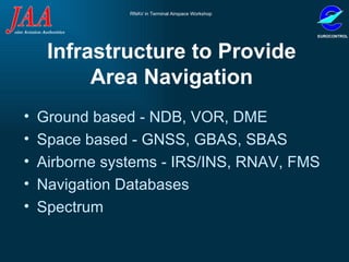
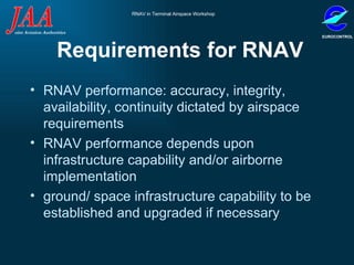
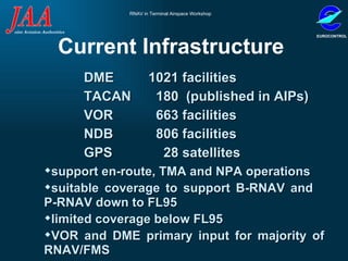
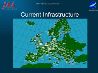
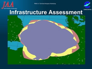
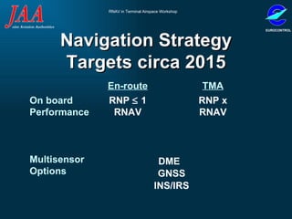
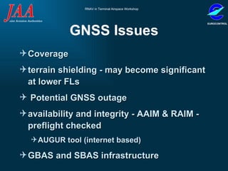
ASSESSMENT OF NAVIGATION INFRASTRUCTURE FOR RNAV Presented by   G. Richards
Presentation Overview Requirements  Infrastructure evolution  Associated Issues
Infrastructure to Provide Area Navigation Ground based - NDB, VOR, DME Space based - GNSS, GBAS, SBAS Airborne systems - IRS/INS, RNAV, FMS Navigation Databases  Spectrum
Requirements for RNAV RNAV performance: accuracy, integrity, availability, continuity dictated by airspace requirements RNAV performance depends upon infrastructure capability and/or airborne implementation ground/ space infrastructure capability to be established and upgraded if necessary
TGL Requirements Suitable Infrastructure TGL 2  B-RNAV   TGL10  P-RNAV      VOR/DME   VOR/DME *     DME/DME    DME/DME     Loran C*    INS*/IRS    INS/IRS     GPS*    GNSS (ABAS)*   * operational limitations   VOR, DME and NDB required to ensure reversionary capability
Operational Requirements  navigation infrastructure monitoring  multi-sensor  RNAV systems  (>1 source)  reversionary capability until 2010  (VOR, DME, NDB)  equipment conformance to RNAV MASPS after 2010  identification of critical navigation aids  obstacle clearance assessment based upon the infrastructure giving the worst case performance  database integrity checked pre-flight
Nav Data Requirements all co-ordinates shall be published in the WGS-84 reference system  data quality (content, integrity, timeliness, consistency) maintained from survey  through to end-user
Strategic Requirements “ a judicious deployment of space based infrastructure and rationalisation of ground infrastructure”  cost effective, customer oriented evolution results in cost savings to Service Providers, which may be  translated in lower route charges to Operators  avionics equipage costs should be minimised
Current Infrastructure  DME  1021 facilities  TACAN    180  (published in AIPs) VOR    663 facilities NDB    806 facilities GPS    28 satellites support en-route, TMA and NPA operations  suitable coverage to support B-RNAV and  P-RNAV down to FL95  limited coverage below FL95  VOR and DME primary input for majority of RNAV/FMS
Current Infrastructure
Infrastructure Assessment
Navigation Infrastructure Evolution 2010 2005 2000 2015 DME   GPS   SBAS   GBAS   NDB   VOR   GALILEO
Navigation Strategy Targets circa 2015 En-route TMA On board Performance  Multisensor Options RNP    1 RNAV RNP x RNAV DME GNSS INS/IRS
VOR&DME Issues coverage - line of sight; limited to DOC - significant at lower FLs DME/DME performance dependant on geometry  (subtended angle)  limited DME transponder capacity (may become significant in TMA)  high costs of VOR facilities  rationalisation - Demeter tool
GNSS Issues Coverage  terrain shielding - may become significant at lower FLs Potential GNSS outage availability and integrity - AAIM & RAIM - preflight checked  AUGUR tool (internet based) GBAS and SBAS infrastructure
Data Issues  ICAO SARPS Annex 15 integrity requirements  for aeronautical co-ordinate data are not met. Electronic Format Transfer to a Common Format Identifiers Resolution of Inconsistencies Traceability CRCs/Headers/Completeness AIP Formats Old to New Consistency Resolution/Accuracy/Multiples WGS84 Compliance Use of * for Non-Compliance
Spectrum Issues  threats from other industries e.g. telecoms and from competing aviation systems e.g. DME vs. GNSS regulatory system - commercially driven, aviation not suitably represented  limitations on current and new navigation frequencies  aviation plans unreliable and incoherent e.g. ILS/VOR vs. FM Broadcast
Summary Requirements  Infrastructure evolution  Evolution:  rationalisation GNSS development High integrity database New frequencies Avionics for RNAV Stakeholder’s commitment
Questions??
Title Text Text Text

Wgs 84 Ref Rnav

  • 1.
    ASSESSMENT OF NAVIGATIONINFRASTRUCTURE FOR RNAV Presented by G. Richards
  • 2.
    Presentation Overview Requirements Infrastructure evolution Associated Issues
  • 3.
    Infrastructure to ProvideArea Navigation Ground based - NDB, VOR, DME Space based - GNSS, GBAS, SBAS Airborne systems - IRS/INS, RNAV, FMS Navigation Databases Spectrum
  • 4.
    Requirements for RNAVRNAV performance: accuracy, integrity, availability, continuity dictated by airspace requirements RNAV performance depends upon infrastructure capability and/or airborne implementation ground/ space infrastructure capability to be established and upgraded if necessary
  • 5.
    TGL Requirements SuitableInfrastructure TGL 2 B-RNAV TGL10 P-RNAV  VOR/DME  VOR/DME *  DME/DME  DME/DME  Loran C*  INS*/IRS  INS/IRS  GPS*  GNSS (ABAS)* * operational limitations VOR, DME and NDB required to ensure reversionary capability
  • 6.
    Operational Requirements navigation infrastructure monitoring multi-sensor RNAV systems (>1 source) reversionary capability until 2010 (VOR, DME, NDB) equipment conformance to RNAV MASPS after 2010 identification of critical navigation aids obstacle clearance assessment based upon the infrastructure giving the worst case performance database integrity checked pre-flight
  • 7.
    Nav Data Requirementsall co-ordinates shall be published in the WGS-84 reference system data quality (content, integrity, timeliness, consistency) maintained from survey through to end-user
  • 8.
    Strategic Requirements “a judicious deployment of space based infrastructure and rationalisation of ground infrastructure” cost effective, customer oriented evolution results in cost savings to Service Providers, which may be translated in lower route charges to Operators avionics equipage costs should be minimised
  • 9.
    Current Infrastructure DME 1021 facilities TACAN 180 (published in AIPs) VOR 663 facilities NDB 806 facilities GPS 28 satellites support en-route, TMA and NPA operations suitable coverage to support B-RNAV and P-RNAV down to FL95 limited coverage below FL95 VOR and DME primary input for majority of RNAV/FMS
  • 10.
  • 11.
  • 12.
    Navigation Infrastructure Evolution2010 2005 2000 2015 DME GPS SBAS GBAS NDB VOR GALILEO
  • 13.
    Navigation Strategy Targetscirca 2015 En-route TMA On board Performance Multisensor Options RNP  1 RNAV RNP x RNAV DME GNSS INS/IRS
  • 14.
    VOR&DME Issues coverage- line of sight; limited to DOC - significant at lower FLs DME/DME performance dependant on geometry (subtended angle) limited DME transponder capacity (may become significant in TMA) high costs of VOR facilities rationalisation - Demeter tool
  • 15.
    GNSS Issues Coverage terrain shielding - may become significant at lower FLs Potential GNSS outage availability and integrity - AAIM & RAIM - preflight checked AUGUR tool (internet based) GBAS and SBAS infrastructure
  • 16.
    Data Issues ICAO SARPS Annex 15 integrity requirements for aeronautical co-ordinate data are not met. Electronic Format Transfer to a Common Format Identifiers Resolution of Inconsistencies Traceability CRCs/Headers/Completeness AIP Formats Old to New Consistency Resolution/Accuracy/Multiples WGS84 Compliance Use of * for Non-Compliance
  • 17.
    Spectrum Issues threats from other industries e.g. telecoms and from competing aviation systems e.g. DME vs. GNSS regulatory system - commercially driven, aviation not suitably represented limitations on current and new navigation frequencies aviation plans unreliable and incoherent e.g. ILS/VOR vs. FM Broadcast
  • 18.
    Summary Requirements Infrastructure evolution Evolution: rationalisation GNSS development High integrity database New frequencies Avionics for RNAV Stakeholder’s commitment
  • 19.
  • 20.