SlideShare a Scribd company logo
Activity No: 01 Date: 10-01-2018
SITE OBSERVATION
Name of the Site: Near Ranodevi
Plan Structure
TotalArea used for Plan
Total Area for Ground floor = 54 fit. × 41.6 fit.
Length= 54fit.
Breadth= 41.6fit.
Total Area Cover for Plan= 54 fit. × 41.6 fit.
= 2,246.4 Sq. Fit
Deduction Area from Plan
Deduct Area: 5.6 fit. × 4.6 fit.
Length= 5.6 fit.
Breadth= 4.6 fit.
No. of Deduct Area= 4
Total Deduction Area= 5.6 fit. × 4.6 fit. × 4
=103.04 Sq. Fit
FloorArea for Plan
F.A= Total Area of G.F – Total Deduction Area
= 2,246.4 – 103.04 Sq. Fit
= 2,143.36 Sq. Fit
Steelused in Plan:
Mainbar:
Top-16 mm (02 pieces)
Bottom- 16 mm (02 pieces)
For 7 Fit
Top-20 mm (01 piece)
For 17 Fit
In top middle- 16 mm (01 piece)
For 12 fit
Bottom-middle- 16 mm (02 pieces)
Ring:
Ring spacing will be use like 6’’8’’6’’8’’………….cont.
Activity No: 02 Date: 10-01-2018
Leveling
Name of the Place: Triangle to ITI block in CUTM, Campus.
THEORY OF LEVELLING
Levelling is a process of transferring height of a “datum” from one point to another. It is used
in engineering to establish building elevations, layout of highways, determinations of flood
plains, calculate volumes in earthwork, design and layout of sewage and water lines, develop
topographic maps, and student crustal-earth movements.
Levelling operations is a level readings can be taken either from one location (one-set-up
levelling) or from various stations, if some points of interest are not visible. A level survey
can be used for setting-out purposes, the presentation of soil profiles etc., as will be discussed
later in the subject.
Basic definitions of Back sight (BS) first staff reading taken immediately after setting up the
instrument.
Foresight (FS) last staff reading taken before moving the instrument to another location.
Intermediate sight (IS): all readings taken between a BS and FS.
So if the instrument is set up at one location only, there will be just one BS (first reading to a
TBM). One FS (last reading) and several IS.
Instruments Required:
 Dumpy level
 Leveling Staff
 Tripod Stand
 Taps
Procedure:
 Let A and B the two points as shown in fig. the position of each setup of level should
be selected that staff kept on the point visible through the telescope.
 Let O1, O2, O3 be position of the level to be setup, choose the change point 1.2 etc.
on the ground so the position of the level should be midway between two staff
reading.
 Now setup the level O1 take the reading on the staff kept vertically with bobble
central.
 This will be a back sight.
 Now select the position of C.P.O so that distance of it from O1 is approximately equal
to that O1.
 With the bubble in the centre take the reading the staff held vertically, over the change
point.
 This will be fore sight continuous.
 Now shift the level O2 and setup it there carefully, with the bubble then kept
vertically as the fore sight over C.P (01).
 This will be back sight in the same line.
 Select another C.P (02) on the ground and level with the bubble kept reading.
 This will be fore sight in the level in the next line.
 Repeat the process until the point B.M reached.
 The least reading will be fore sight.
 Now find out the RL by HI methods or by rise and fall method.
 Apply the arithmetical check.
Observationand Calculations:
Now, we are going to be calculate by using the rise and fall method.
∑BS - ∑FS ∑RISE - ∑FALL
= (6.00 – 5.45) = (2.280 – 1.73)
= 0.55M. = 0.55M.
Hence, by using rise and fall method we found that the level difference from triangle to ITI
block was 0.55m.
Conclusion:
 After completion of this experiment we found that the level difference from triangle
to ITI block was 0.55m.
 We calculated by using the rise and fall method.
Activity No: 03 Date: 11-01-2018
Leveling
Name of the Place: Triangle to ITI block in CUTM, Campus.
THEORY OF LEVELLING
Levelling is a process of transferring height of a “datum” from one point to another. It is used
in engineering to establish building elevations, layout of highways, determinations of flood
plains, calculate volumes in earthwork, design and layout of sewage and water lines, develop
topographic maps, and student crustal-earth movements.
Levelling operations is a level readings can be taken either from one location (one-set-up
levelling) or from various stations, if some points of interest are not visible. A level survey
can be used for setting-out purposes, the presentation of soil profiles etc., as will be discussed
later in the subject.
Basic definitions of Back sight (BS) first staff reading taken immediately after setting up the
instrument.
Foresight (FS) last staff reading taken before moving the instrument to another location.
Intermediate sight (IS): all readings taken between a BS and FS.
So if the instrument is set up at one location only, there will be just one BS (first reading to a
TBM). One FS (last reading) and several IS.
Instruments Required:
 Dumpy level
 Leveling Staff
 Tripod Stand
 Taps
Procedure:
 Let A and B the two points as shown in fig. the position of each setup of level should
be selected that staff kept on the point visible through the telescope.
 Let O1, O2, O3 be position of the level to be setup, choose the change point 1.2 etc.
on the ground so the position of the level should be midway between two staff
reading.
 Now setup the level O1 take the reading on the staff kept vertically with bobble
central.
 This will be a back sight.
 Now select the position of C.P.O so that distance of it from O1 is approximately equal
to that O1.
 With the bubble in the centre take the reading the staff held vertically, over the change
point.
 This will be fore sight continuous.
 Now shift the level O2 and setup it there carefully, with the bubble then kept
vertically as the fore sight over C.P (01).
 This will be back sight in the same line.
 Select another C.P (02) on the ground and level with the bubble kept reading.
 This will be fore sight in the level in the next line.
 Repeat the process until the point B.M reached.
 The least reading will be fore sight.
 Now find out the RL by HI methods or by rise and fall method.
 Apply the arithmetical check.
Observationand Calculations:
Now, we are going to be calculate by using the HI method.
∑BS - ∑FS ∑LAST RL - ∑FIRST RL
= (6.00 – 5.48) = (100.520 - 100)
= 0.52M. = 0.52M.
Hence, by using HI method we found that the level difference from triangle to ITI block was
0.52m.
Conclusion:
 After completion of this experiment we found that the level difference from triangle
to ITI block was 0.52m.
 We calculated by using the HI method.
Activity No: 04 Date: 18-01-2018
Leveling
Name of the Place: ITI block to ground in CUTM, Campus.
THEORY OF LEVELLING
Levelling is a process of transferring height of a “datum” from one point to another. It is used
in engineering to establish building elevations, layout of highways, determinations of flood
plains, calculate volumes in earthwork, design and layout of sewage and water lines, develop
topographic maps, and student crustal-earth movements.
Levelling operations is a level readings can be taken either from one location (one-set-up
levelling) or from various stations, if some points of interest are not visible. A level survey
can be used for setting-out purposes, the presentation of soil profiles etc., as will be discussed
later in the subject.
Basic definitions of Back sight (BS) first staff reading taken immediately after setting up the
instrument.
Foresight (FS) last staff reading taken before moving the instrument to another location.
Intermediate sight (IS): all readings taken between a BS and FS.
So if the instrument is set up at one location only, there will be just one BS (first reading to a
TBM). One FS (last reading) and several IS.
Instruments Required:
 Dumpy level
 Leveling Staff
 Tripod Stand
 Taps
Procedure:
 Let A and B the two points as shown in fig. the position of each setup of level should
be selected that staff kept on the point visible through the telescope.
 Let O1, O2, O3 be position of the level to be setup, choose the change point 1.2 etc.
on the ground so the position of the level should be midway between two staff
reading.
 Now setup the level O1 take the reading on the staff kept vertically with bobble
central.
 This will be a back sight.
 Now select the position of C.P.O so that distance of it from O1 is approximately equal
to that O1.
 With the bubble in the centre take the reading the staff held vertically, over the change
point.
 This will be fore sight continuous.
 Now shift the level O2 and setup it there carefully, with the bubble then kept
vertically as the fore sight over C.P (01).
 This will be back sight in the same line.
 Select another C.P (02) on the ground and level with the bubble kept reading.
 This will be fore sight in the level in the next line.
 Repeat the process until the point B.M reached.
 The least reading will be fore sight.
 Now find out the RL by HI methods or by rise and fall method.
 Apply the arithmetical check.
Observationand Calculations:
Now, we are going to be calculate by using the HI method.
∑BS - ∑FS ∑LAST RL - ∑FIRST RL
= (8.330 – 18.290) = (90.04 - 100)
= -9.96M. = -9.96M.
Hence, by using HI method we found that the level difference from triangle to ITI block was
-9.96m.
Conclusion:
 After completion of this experiment we found that the level difference from triangle
to ITI block was -9.96m.
 We calculated by using the HI method.

More Related Content

What's hot

Leveling, Instruments of Leveling, Bearings (Surveying, ECE)
Leveling, Instruments of Leveling, Bearings (Surveying, ECE) Leveling, Instruments of Leveling, Bearings (Surveying, ECE)
Leveling, Instruments of Leveling, Bearings (Surveying, ECE)
Kaushal Mehta
 
engineering survey 1 report levelling
engineering survey 1 report levellingengineering survey 1 report levelling
engineering survey 1 report levelling
YASMINE HASLAN
 
Surveying - Module iii-levelling only note
Surveying - Module  iii-levelling only noteSurveying - Module  iii-levelling only note
Surveying - Module iii-levelling only note
SHAMJITH KM
 
Site Surveying Leveling
Site Surveying LevelingSite Surveying Leveling
Site Surveying Leveling
ashleyyeap
 
Levelling report
Levelling reportLevelling report
Levelling report
Shze Hwa Lee
 
Basics Of Surveying
Basics Of SurveyingBasics Of Surveying
Basics Of Surveyingstooty s
 
Site surveying report 2
Site surveying report 2Site surveying report 2
Site surveying report 2
Doreen Yeo
 
Levelling report-1
Levelling report-1Levelling report-1
Levelling report-1
tfkc1212
 
S2 2 leveling
S2 2 levelingS2 2 leveling
S2 2 leveling
Est
 
Assignment 1 - Levelling
Assignment 1 - LevellingAssignment 1 - Levelling
Assignment 1 - Levelling
Kai Yun Pang
 
Levelling
LevellingLevelling
Levelling
Diana Dian
 
Levelling, terms related to levelling, methods of levelling
Levelling, terms related to levelling, methods of levellingLevelling, terms related to levelling, methods of levelling
Levelling, terms related to levelling, methods of levelling
Mir Zafarullah
 
Ss report 1
Ss report 1Ss report 1
Ss report 1
Pang Shuen
 
LEVELING AND CONTOURING
LEVELING AND CONTOURINGLEVELING AND CONTOURING
LEVELING AND CONTOURING
ANAND JIBHKATE
 
B.sc. agri i foswce unit 2 leveling
B.sc. agri i foswce unit 2 levelingB.sc. agri i foswce unit 2 leveling
B.sc. agri i foswce unit 2 leveling
Rai University
 
Site Surveying Report 1 (Levelling)
Site Surveying Report 1 (Levelling)Site Surveying Report 1 (Levelling)
Site Surveying Report 1 (Levelling)
Haziq1511
 
Ss report 1 ----levelling eport
Ss report 1 ----levelling eportSs report 1 ----levelling eport
Ss report 1 ----levelling eport
MELVIN tan
 
levelling and contouring
levelling and contouringlevelling and contouring
levelling and contouring
ANAND JIBHKATE
 
Site surveying-report-leveling
Site surveying-report-levelingSite surveying-report-leveling
Site surveying-report-levelingXinYee Khoo
 

What's hot (19)

Leveling, Instruments of Leveling, Bearings (Surveying, ECE)
Leveling, Instruments of Leveling, Bearings (Surveying, ECE) Leveling, Instruments of Leveling, Bearings (Surveying, ECE)
Leveling, Instruments of Leveling, Bearings (Surveying, ECE)
 
engineering survey 1 report levelling
engineering survey 1 report levellingengineering survey 1 report levelling
engineering survey 1 report levelling
 
Surveying - Module iii-levelling only note
Surveying - Module  iii-levelling only noteSurveying - Module  iii-levelling only note
Surveying - Module iii-levelling only note
 
Site Surveying Leveling
Site Surveying LevelingSite Surveying Leveling
Site Surveying Leveling
 
Levelling report
Levelling reportLevelling report
Levelling report
 
Basics Of Surveying
Basics Of SurveyingBasics Of Surveying
Basics Of Surveying
 
Site surveying report 2
Site surveying report 2Site surveying report 2
Site surveying report 2
 
Levelling report-1
Levelling report-1Levelling report-1
Levelling report-1
 
S2 2 leveling
S2 2 levelingS2 2 leveling
S2 2 leveling
 
Assignment 1 - Levelling
Assignment 1 - LevellingAssignment 1 - Levelling
Assignment 1 - Levelling
 
Levelling
LevellingLevelling
Levelling
 
Levelling, terms related to levelling, methods of levelling
Levelling, terms related to levelling, methods of levellingLevelling, terms related to levelling, methods of levelling
Levelling, terms related to levelling, methods of levelling
 
Ss report 1
Ss report 1Ss report 1
Ss report 1
 
LEVELING AND CONTOURING
LEVELING AND CONTOURINGLEVELING AND CONTOURING
LEVELING AND CONTOURING
 
B.sc. agri i foswce unit 2 leveling
B.sc. agri i foswce unit 2 levelingB.sc. agri i foswce unit 2 leveling
B.sc. agri i foswce unit 2 leveling
 
Site Surveying Report 1 (Levelling)
Site Surveying Report 1 (Levelling)Site Surveying Report 1 (Levelling)
Site Surveying Report 1 (Levelling)
 
Ss report 1 ----levelling eport
Ss report 1 ----levelling eportSs report 1 ----levelling eport
Ss report 1 ----levelling eport
 
levelling and contouring
levelling and contouringlevelling and contouring
levelling and contouring
 
Site surveying-report-leveling
Site surveying-report-levelingSite surveying-report-leveling
Site surveying-report-leveling
 

Similar to Activity no 1

Levelling in Surveying
Levelling in SurveyingLevelling in Surveying
Levelling in Surveying
Phurba Tamang
 
SITE SURVEYING LEVELING
SITE SURVEYING LEVELINGSITE SURVEYING LEVELING
SITE SURVEYING LEVELING
Farah Sham
 
Levelling @surveyingreport
Levelling @surveyingreportLevelling @surveyingreport
Levelling @surveyingreport
KiplimoCalvin
 
LEVELING.pdf
LEVELING.pdfLEVELING.pdf
LEVELING.pdf
pradeep madhuranga
 
Ss report 1
Ss report 1Ss report 1
Ss report 1
Shen Sin
 
1. Practical assessment-Carry out levelling operations
1. Practical assessment-Carry out levelling operations1. Practical assessment-Carry out levelling operations
1. Practical assessment-Carry out levelling operations
Canberra Institute of technology
 
Site Surveying Report - Traversing
Site Surveying Report - TraversingSite Surveying Report - Traversing
Site Surveying Report - Traversing
XinYee Khoo
 
Practical assessment 1-Carry out levelling operations
Practical assessment 1-Carry out levelling operationsPractical assessment 1-Carry out levelling operations
Practical assessment 1-Carry out levelling operations
Canberra Institute of technology
 
Site surveying report i
Site surveying   report iSite surveying   report i
Site surveying report i마 이환
 
Altimetria (1ra clase)
Altimetria (1ra clase)Altimetria (1ra clase)
Altimetria (1ra clase)
JulioCesarCanelas
 
SWE 112 soil and water conservation engineering
SWE 112 soil and water conservation engineeringSWE 112 soil and water conservation engineering
SWE 112 soil and water conservation engineering
MelusinaNorwood
 
2. Practical assessment Carry out Levelling Operations
2. Practical assessment Carry out Levelling Operations2. Practical assessment Carry out Levelling Operations
2. Practical assessment Carry out Levelling Operations
Canberra Institute of technology
 
Lecture 7 topographic related documents Survey
Lecture 7 topographic related documents  SurveyLecture 7 topographic related documents  Survey
Lecture 7 topographic related documents Survey
40023ce
 
Levelling
LevellingLevelling
Levelling
Arissa Loh
 
Levelling
LevellingLevelling
UNIT FOUR.pptx
UNIT FOUR.pptxUNIT FOUR.pptx
UNIT FOUR.pptx
warkisafile1
 
SSA LESSON 5- LEVELLING- AV.pptx
SSA LESSON 5- LEVELLING- AV.pptxSSA LESSON 5- LEVELLING- AV.pptx
SSA LESSON 5- LEVELLING- AV.pptx
AkashV75
 
Practical assessment 2- Carry out Levelling
Practical assessment 2- Carry out LevellingPractical assessment 2- Carry out Levelling
Practical assessment 2- Carry out Levelling
Canberra Institute of technology
 
levelling and contouring
 levelling and  contouring levelling and  contouring
levelling and contouring
Abdul Majid
 

Similar to Activity no 1 (20)

Levelling in Surveying
Levelling in SurveyingLevelling in Surveying
Levelling in Surveying
 
SITE SURVEYING LEVELING
SITE SURVEYING LEVELINGSITE SURVEYING LEVELING
SITE SURVEYING LEVELING
 
Levelling @surveyingreport
Levelling @surveyingreportLevelling @surveyingreport
Levelling @surveyingreport
 
LEVELING.pdf
LEVELING.pdfLEVELING.pdf
LEVELING.pdf
 
Ss report 1
Ss report 1Ss report 1
Ss report 1
 
1. Practical assessment-Carry out levelling operations
1. Practical assessment-Carry out levelling operations1. Practical assessment-Carry out levelling operations
1. Practical assessment-Carry out levelling operations
 
Site Surveying Report - Traversing
Site Surveying Report - TraversingSite Surveying Report - Traversing
Site Surveying Report - Traversing
 
Practical assessment 1-Carry out levelling operations
Practical assessment 1-Carry out levelling operationsPractical assessment 1-Carry out levelling operations
Practical assessment 1-Carry out levelling operations
 
Site surveying report i
Site surveying   report iSite surveying   report i
Site surveying report i
 
Altimetria (1ra clase)
Altimetria (1ra clase)Altimetria (1ra clase)
Altimetria (1ra clase)
 
SWE 112 soil and water conservation engineering
SWE 112 soil and water conservation engineeringSWE 112 soil and water conservation engineering
SWE 112 soil and water conservation engineering
 
Levelling
LevellingLevelling
Levelling
 
2. Practical assessment Carry out Levelling Operations
2. Practical assessment Carry out Levelling Operations2. Practical assessment Carry out Levelling Operations
2. Practical assessment Carry out Levelling Operations
 
Lecture 7 topographic related documents Survey
Lecture 7 topographic related documents  SurveyLecture 7 topographic related documents  Survey
Lecture 7 topographic related documents Survey
 
Levelling
LevellingLevelling
Levelling
 
Levelling
LevellingLevelling
Levelling
 
UNIT FOUR.pptx
UNIT FOUR.pptxUNIT FOUR.pptx
UNIT FOUR.pptx
 
SSA LESSON 5- LEVELLING- AV.pptx
SSA LESSON 5- LEVELLING- AV.pptxSSA LESSON 5- LEVELLING- AV.pptx
SSA LESSON 5- LEVELLING- AV.pptx
 
Practical assessment 2- Carry out Levelling
Practical assessment 2- Carry out LevellingPractical assessment 2- Carry out Levelling
Practical assessment 2- Carry out Levelling
 
levelling and contouring
 levelling and  contouring levelling and  contouring
levelling and contouring
 

Recently uploaded

block diagram and signal flow graph representation
block diagram and signal flow graph representationblock diagram and signal flow graph representation
block diagram and signal flow graph representation
Divya Somashekar
 
ML for identifying fraud using open blockchain data.pptx
ML for identifying fraud using open blockchain data.pptxML for identifying fraud using open blockchain data.pptx
ML for identifying fraud using open blockchain data.pptx
Vijay Dialani, PhD
 
Final project report on grocery store management system..pdf
Final project report on grocery store management system..pdfFinal project report on grocery store management system..pdf
Final project report on grocery store management system..pdf
Kamal Acharya
 
space technology lecture notes on satellite
space technology lecture notes on satellitespace technology lecture notes on satellite
space technology lecture notes on satellite
ongomchris
 
在线办理(ANU毕业证书)澳洲国立大学毕业证录取通知书一模一样
在线办理(ANU毕业证书)澳洲国立大学毕业证录取通知书一模一样在线办理(ANU毕业证书)澳洲国立大学毕业证录取通知书一模一样
在线办理(ANU毕业证书)澳洲国立大学毕业证录取通知书一模一样
obonagu
 
Investor-Presentation-Q1FY2024 investor presentation document.pptx
Investor-Presentation-Q1FY2024 investor presentation document.pptxInvestor-Presentation-Q1FY2024 investor presentation document.pptx
Investor-Presentation-Q1FY2024 investor presentation document.pptx
AmarGB2
 
ASME IX(9) 2007 Full Version .pdf
ASME IX(9)  2007 Full Version       .pdfASME IX(9)  2007 Full Version       .pdf
ASME IX(9) 2007 Full Version .pdf
AhmedHussein950959
 
CFD Simulation of By-pass Flow in a HRSG module by R&R Consult.pptx
CFD Simulation of By-pass Flow in a HRSG module by R&R Consult.pptxCFD Simulation of By-pass Flow in a HRSG module by R&R Consult.pptx
CFD Simulation of By-pass Flow in a HRSG module by R&R Consult.pptx
R&R Consult
 
weather web application report.pdf
weather web application report.pdfweather web application report.pdf
weather web application report.pdf
Pratik Pawar
 
一比一原版(UofT毕业证)多伦多大学毕业证成绩单如何办理
一比一原版(UofT毕业证)多伦多大学毕业证成绩单如何办理一比一原版(UofT毕业证)多伦多大学毕业证成绩单如何办理
一比一原版(UofT毕业证)多伦多大学毕业证成绩单如何办理
ydteq
 
Immunizing Image Classifiers Against Localized Adversary Attacks
Immunizing Image Classifiers Against Localized Adversary AttacksImmunizing Image Classifiers Against Localized Adversary Attacks
Immunizing Image Classifiers Against Localized Adversary Attacks
gerogepatton
 
WATER CRISIS and its solutions-pptx 1234
WATER CRISIS and its solutions-pptx 1234WATER CRISIS and its solutions-pptx 1234
WATER CRISIS and its solutions-pptx 1234
AafreenAbuthahir2
 
Runway Orientation Based on the Wind Rose Diagram.pptx
Runway Orientation Based on the Wind Rose Diagram.pptxRunway Orientation Based on the Wind Rose Diagram.pptx
Runway Orientation Based on the Wind Rose Diagram.pptx
SupreethSP4
 
Top 10 Oil and Gas Projects in Saudi Arabia 2024.pdf
Top 10 Oil and Gas Projects in Saudi Arabia 2024.pdfTop 10 Oil and Gas Projects in Saudi Arabia 2024.pdf
Top 10 Oil and Gas Projects in Saudi Arabia 2024.pdf
Teleport Manpower Consultant
 
J.Yang, ICLR 2024, MLILAB, KAIST AI.pdf
J.Yang,  ICLR 2024, MLILAB, KAIST AI.pdfJ.Yang,  ICLR 2024, MLILAB, KAIST AI.pdf
J.Yang, ICLR 2024, MLILAB, KAIST AI.pdf
MLILAB
 
H.Seo, ICLR 2024, MLILAB, KAIST AI.pdf
H.Seo,  ICLR 2024, MLILAB,  KAIST AI.pdfH.Seo,  ICLR 2024, MLILAB,  KAIST AI.pdf
H.Seo, ICLR 2024, MLILAB, KAIST AI.pdf
MLILAB
 
Cosmetic shop management system project report.pdf
Cosmetic shop management system project report.pdfCosmetic shop management system project report.pdf
Cosmetic shop management system project report.pdf
Kamal Acharya
 
Nuclear Power Economics and Structuring 2024
Nuclear Power Economics and Structuring 2024Nuclear Power Economics and Structuring 2024
Nuclear Power Economics and Structuring 2024
Massimo Talia
 
Sachpazis:Terzaghi Bearing Capacity Estimation in simple terms with Calculati...
Sachpazis:Terzaghi Bearing Capacity Estimation in simple terms with Calculati...Sachpazis:Terzaghi Bearing Capacity Estimation in simple terms with Calculati...
Sachpazis:Terzaghi Bearing Capacity Estimation in simple terms with Calculati...
Dr.Costas Sachpazis
 
The Benefits and Techniques of Trenchless Pipe Repair.pdf
The Benefits and Techniques of Trenchless Pipe Repair.pdfThe Benefits and Techniques of Trenchless Pipe Repair.pdf
The Benefits and Techniques of Trenchless Pipe Repair.pdf
Pipe Restoration Solutions
 

Recently uploaded (20)

block diagram and signal flow graph representation
block diagram and signal flow graph representationblock diagram and signal flow graph representation
block diagram and signal flow graph representation
 
ML for identifying fraud using open blockchain data.pptx
ML for identifying fraud using open blockchain data.pptxML for identifying fraud using open blockchain data.pptx
ML for identifying fraud using open blockchain data.pptx
 
Final project report on grocery store management system..pdf
Final project report on grocery store management system..pdfFinal project report on grocery store management system..pdf
Final project report on grocery store management system..pdf
 
space technology lecture notes on satellite
space technology lecture notes on satellitespace technology lecture notes on satellite
space technology lecture notes on satellite
 
在线办理(ANU毕业证书)澳洲国立大学毕业证录取通知书一模一样
在线办理(ANU毕业证书)澳洲国立大学毕业证录取通知书一模一样在线办理(ANU毕业证书)澳洲国立大学毕业证录取通知书一模一样
在线办理(ANU毕业证书)澳洲国立大学毕业证录取通知书一模一样
 
Investor-Presentation-Q1FY2024 investor presentation document.pptx
Investor-Presentation-Q1FY2024 investor presentation document.pptxInvestor-Presentation-Q1FY2024 investor presentation document.pptx
Investor-Presentation-Q1FY2024 investor presentation document.pptx
 
ASME IX(9) 2007 Full Version .pdf
ASME IX(9)  2007 Full Version       .pdfASME IX(9)  2007 Full Version       .pdf
ASME IX(9) 2007 Full Version .pdf
 
CFD Simulation of By-pass Flow in a HRSG module by R&R Consult.pptx
CFD Simulation of By-pass Flow in a HRSG module by R&R Consult.pptxCFD Simulation of By-pass Flow in a HRSG module by R&R Consult.pptx
CFD Simulation of By-pass Flow in a HRSG module by R&R Consult.pptx
 
weather web application report.pdf
weather web application report.pdfweather web application report.pdf
weather web application report.pdf
 
一比一原版(UofT毕业证)多伦多大学毕业证成绩单如何办理
一比一原版(UofT毕业证)多伦多大学毕业证成绩单如何办理一比一原版(UofT毕业证)多伦多大学毕业证成绩单如何办理
一比一原版(UofT毕业证)多伦多大学毕业证成绩单如何办理
 
Immunizing Image Classifiers Against Localized Adversary Attacks
Immunizing Image Classifiers Against Localized Adversary AttacksImmunizing Image Classifiers Against Localized Adversary Attacks
Immunizing Image Classifiers Against Localized Adversary Attacks
 
WATER CRISIS and its solutions-pptx 1234
WATER CRISIS and its solutions-pptx 1234WATER CRISIS and its solutions-pptx 1234
WATER CRISIS and its solutions-pptx 1234
 
Runway Orientation Based on the Wind Rose Diagram.pptx
Runway Orientation Based on the Wind Rose Diagram.pptxRunway Orientation Based on the Wind Rose Diagram.pptx
Runway Orientation Based on the Wind Rose Diagram.pptx
 
Top 10 Oil and Gas Projects in Saudi Arabia 2024.pdf
Top 10 Oil and Gas Projects in Saudi Arabia 2024.pdfTop 10 Oil and Gas Projects in Saudi Arabia 2024.pdf
Top 10 Oil and Gas Projects in Saudi Arabia 2024.pdf
 
J.Yang, ICLR 2024, MLILAB, KAIST AI.pdf
J.Yang,  ICLR 2024, MLILAB, KAIST AI.pdfJ.Yang,  ICLR 2024, MLILAB, KAIST AI.pdf
J.Yang, ICLR 2024, MLILAB, KAIST AI.pdf
 
H.Seo, ICLR 2024, MLILAB, KAIST AI.pdf
H.Seo,  ICLR 2024, MLILAB,  KAIST AI.pdfH.Seo,  ICLR 2024, MLILAB,  KAIST AI.pdf
H.Seo, ICLR 2024, MLILAB, KAIST AI.pdf
 
Cosmetic shop management system project report.pdf
Cosmetic shop management system project report.pdfCosmetic shop management system project report.pdf
Cosmetic shop management system project report.pdf
 
Nuclear Power Economics and Structuring 2024
Nuclear Power Economics and Structuring 2024Nuclear Power Economics and Structuring 2024
Nuclear Power Economics and Structuring 2024
 
Sachpazis:Terzaghi Bearing Capacity Estimation in simple terms with Calculati...
Sachpazis:Terzaghi Bearing Capacity Estimation in simple terms with Calculati...Sachpazis:Terzaghi Bearing Capacity Estimation in simple terms with Calculati...
Sachpazis:Terzaghi Bearing Capacity Estimation in simple terms with Calculati...
 
The Benefits and Techniques of Trenchless Pipe Repair.pdf
The Benefits and Techniques of Trenchless Pipe Repair.pdfThe Benefits and Techniques of Trenchless Pipe Repair.pdf
The Benefits and Techniques of Trenchless Pipe Repair.pdf
 

Activity no 1

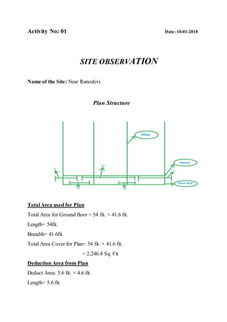
  • 1. Activity No: 01 Date: 10-01-2018 SITE OBSERVATION Name of the Site: Near Ranodevi Plan Structure TotalArea used for Plan Total Area for Ground floor = 54 fit. × 41.6 fit. Length= 54fit. Breadth= 41.6fit. Total Area Cover for Plan= 54 fit. × 41.6 fit. = 2,246.4 Sq. Fit Deduction Area from Plan Deduct Area: 5.6 fit. × 4.6 fit. Length= 5.6 fit.
  • 2. Breadth= 4.6 fit. No. of Deduct Area= 4 Total Deduction Area= 5.6 fit. × 4.6 fit. × 4 =103.04 Sq. Fit FloorArea for Plan F.A= Total Area of G.F – Total Deduction Area = 2,246.4 – 103.04 Sq. Fit = 2,143.36 Sq. Fit Steelused in Plan: Mainbar: Top-16 mm (02 pieces) Bottom- 16 mm (02 pieces) For 7 Fit Top-20 mm (01 piece) For 17 Fit In top middle- 16 mm (01 piece) For 12 fit Bottom-middle- 16 mm (02 pieces) Ring: Ring spacing will be use like 6’’8’’6’’8’’………….cont.
  • 3. Activity No: 02 Date: 10-01-2018 Leveling Name of the Place: Triangle to ITI block in CUTM, Campus. THEORY OF LEVELLING Levelling is a process of transferring height of a “datum” from one point to another. It is used in engineering to establish building elevations, layout of highways, determinations of flood plains, calculate volumes in earthwork, design and layout of sewage and water lines, develop topographic maps, and student crustal-earth movements. Levelling operations is a level readings can be taken either from one location (one-set-up levelling) or from various stations, if some points of interest are not visible. A level survey can be used for setting-out purposes, the presentation of soil profiles etc., as will be discussed later in the subject. Basic definitions of Back sight (BS) first staff reading taken immediately after setting up the instrument. Foresight (FS) last staff reading taken before moving the instrument to another location. Intermediate sight (IS): all readings taken between a BS and FS. So if the instrument is set up at one location only, there will be just one BS (first reading to a TBM). One FS (last reading) and several IS.
  • 4. Instruments Required:  Dumpy level  Leveling Staff  Tripod Stand  Taps Procedure:  Let A and B the two points as shown in fig. the position of each setup of level should be selected that staff kept on the point visible through the telescope.  Let O1, O2, O3 be position of the level to be setup, choose the change point 1.2 etc. on the ground so the position of the level should be midway between two staff reading.  Now setup the level O1 take the reading on the staff kept vertically with bobble central.  This will be a back sight.  Now select the position of C.P.O so that distance of it from O1 is approximately equal to that O1.
  • 5.  With the bubble in the centre take the reading the staff held vertically, over the change point.  This will be fore sight continuous.  Now shift the level O2 and setup it there carefully, with the bubble then kept vertically as the fore sight over C.P (01).  This will be back sight in the same line.  Select another C.P (02) on the ground and level with the bubble kept reading.  This will be fore sight in the level in the next line.  Repeat the process until the point B.M reached.  The least reading will be fore sight.  Now find out the RL by HI methods or by rise and fall method.  Apply the arithmetical check. Observationand Calculations: Now, we are going to be calculate by using the rise and fall method. ∑BS - ∑FS ∑RISE - ∑FALL = (6.00 – 5.45) = (2.280 – 1.73) = 0.55M. = 0.55M. Hence, by using rise and fall method we found that the level difference from triangle to ITI block was 0.55m.
  • 6. Conclusion:  After completion of this experiment we found that the level difference from triangle to ITI block was 0.55m.  We calculated by using the rise and fall method.
  • 7. Activity No: 03 Date: 11-01-2018 Leveling Name of the Place: Triangle to ITI block in CUTM, Campus. THEORY OF LEVELLING Levelling is a process of transferring height of a “datum” from one point to another. It is used in engineering to establish building elevations, layout of highways, determinations of flood plains, calculate volumes in earthwork, design and layout of sewage and water lines, develop topographic maps, and student crustal-earth movements. Levelling operations is a level readings can be taken either from one location (one-set-up levelling) or from various stations, if some points of interest are not visible. A level survey can be used for setting-out purposes, the presentation of soil profiles etc., as will be discussed later in the subject. Basic definitions of Back sight (BS) first staff reading taken immediately after setting up the instrument. Foresight (FS) last staff reading taken before moving the instrument to another location. Intermediate sight (IS): all readings taken between a BS and FS. So if the instrument is set up at one location only, there will be just one BS (first reading to a TBM). One FS (last reading) and several IS.
  • 8. Instruments Required:  Dumpy level  Leveling Staff  Tripod Stand  Taps Procedure:  Let A and B the two points as shown in fig. the position of each setup of level should be selected that staff kept on the point visible through the telescope.  Let O1, O2, O3 be position of the level to be setup, choose the change point 1.2 etc. on the ground so the position of the level should be midway between two staff reading.  Now setup the level O1 take the reading on the staff kept vertically with bobble central.  This will be a back sight.  Now select the position of C.P.O so that distance of it from O1 is approximately equal to that O1.
  • 9.  With the bubble in the centre take the reading the staff held vertically, over the change point.  This will be fore sight continuous.  Now shift the level O2 and setup it there carefully, with the bubble then kept vertically as the fore sight over C.P (01).  This will be back sight in the same line.  Select another C.P (02) on the ground and level with the bubble kept reading.  This will be fore sight in the level in the next line.  Repeat the process until the point B.M reached.  The least reading will be fore sight.  Now find out the RL by HI methods or by rise and fall method.  Apply the arithmetical check. Observationand Calculations: Now, we are going to be calculate by using the HI method. ∑BS - ∑FS ∑LAST RL - ∑FIRST RL = (6.00 – 5.48) = (100.520 - 100) = 0.52M. = 0.52M. Hence, by using HI method we found that the level difference from triangle to ITI block was 0.52m.
  • 10. Conclusion:  After completion of this experiment we found that the level difference from triangle to ITI block was 0.52m.  We calculated by using the HI method.
  • 11. Activity No: 04 Date: 18-01-2018 Leveling Name of the Place: ITI block to ground in CUTM, Campus. THEORY OF LEVELLING Levelling is a process of transferring height of a “datum” from one point to another. It is used in engineering to establish building elevations, layout of highways, determinations of flood plains, calculate volumes in earthwork, design and layout of sewage and water lines, develop topographic maps, and student crustal-earth movements. Levelling operations is a level readings can be taken either from one location (one-set-up levelling) or from various stations, if some points of interest are not visible. A level survey can be used for setting-out purposes, the presentation of soil profiles etc., as will be discussed later in the subject. Basic definitions of Back sight (BS) first staff reading taken immediately after setting up the instrument. Foresight (FS) last staff reading taken before moving the instrument to another location. Intermediate sight (IS): all readings taken between a BS and FS. So if the instrument is set up at one location only, there will be just one BS (first reading to a TBM). One FS (last reading) and several IS.
  • 12. Instruments Required:  Dumpy level  Leveling Staff  Tripod Stand  Taps Procedure:  Let A and B the two points as shown in fig. the position of each setup of level should be selected that staff kept on the point visible through the telescope.  Let O1, O2, O3 be position of the level to be setup, choose the change point 1.2 etc. on the ground so the position of the level should be midway between two staff reading.  Now setup the level O1 take the reading on the staff kept vertically with bobble central.  This will be a back sight.  Now select the position of C.P.O so that distance of it from O1 is approximately equal to that O1.
  • 13.  With the bubble in the centre take the reading the staff held vertically, over the change point.  This will be fore sight continuous.  Now shift the level O2 and setup it there carefully, with the bubble then kept vertically as the fore sight over C.P (01).  This will be back sight in the same line.  Select another C.P (02) on the ground and level with the bubble kept reading.  This will be fore sight in the level in the next line.  Repeat the process until the point B.M reached.  The least reading will be fore sight.  Now find out the RL by HI methods or by rise and fall method.  Apply the arithmetical check. Observationand Calculations: Now, we are going to be calculate by using the HI method.
  • 14. ∑BS - ∑FS ∑LAST RL - ∑FIRST RL = (8.330 – 18.290) = (90.04 - 100) = -9.96M. = -9.96M. Hence, by using HI method we found that the level difference from triangle to ITI block was -9.96m. Conclusion:  After completion of this experiment we found that the level difference from triangle to ITI block was -9.96m.  We calculated by using the HI method.