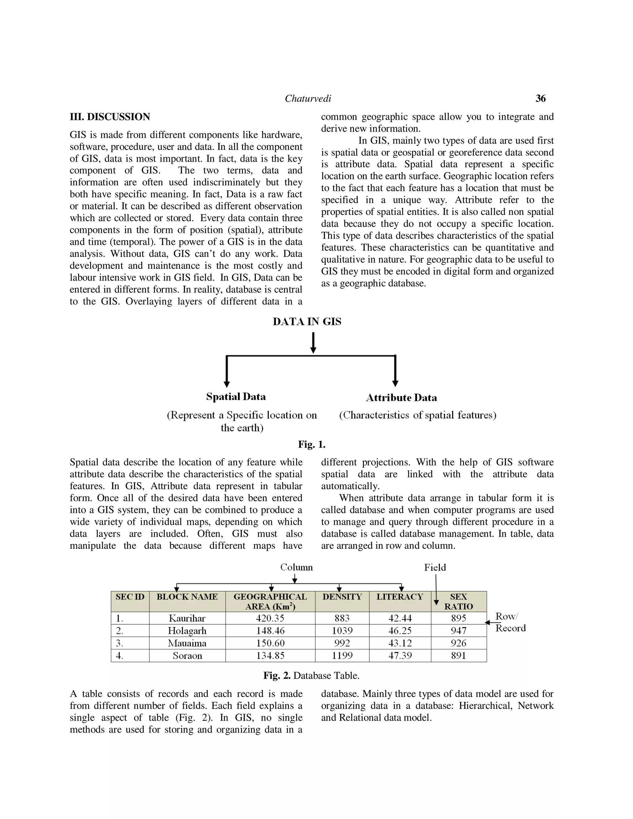
This document discusses the importance of data in geographical information systems (GIS). It states that data is the core component of GIS, as GIS relies on data to perform analysis and display results. The document outlines the different types of data used in GIS, including spatial data that represents geographic locations and attributes, and non-spatial attribute data. It also describes how data is structured, captured, integrated, and edited within a GIS to ensure accuracy and allow for analysis across different data layers. The key role of data in enabling the functionality of GIS tools and applications is emphasized throughout the document.
![ISSN No. (Print): 0975-1718
ISSN No. (Online): 2249-3247
Data: The Core of GIS
Dr. Richa Chaturvedi
Assistant Professor, Department of Geography,
IGNTU, Amarkantak (Madhya Pradesh), India
(Corresponding author: Dr. Richa Chaturvedi)
(Received 03 January, 2018, accepted 24 January, 2018)
(Published by Research Trend, Website: www.researchtrend.net)
ABSTRACT: Geographical Information System is a new branch of information system in which system (GIS
software) containing geographic data and converting useful information. The ability to integrate and analyze
data organized in multiple thematic layers is a heart of Geographical Information System. Hardware,
software, procedure, data and users are different components in which data is essential and core of GIS
because without data GIS cannot work and cannot display the result.
Keywords: Geographical Information System, Raster, Vector, Data.
I. INTRODUCTION
Today, Geographical Information System (GIS) has
become an important field of academic study, one of
the fastest growing sectors of the computer industry and
most important, an essential component of the
information technology (IT) infrastructure of modern
society (Lo and Yeung, 2005) [4]. It is made from two
words Geography and Information System. In
Geography, we study the physical and cultural
component of the earth and information system is
system in which system contain all types of electronic
records. So GIS is a computer based information
system used to digitally represent and analyze the
geospatial data or geographical data (Bhatta, 2008) [2].
The Advent of GIS technology has transformed spatial
data handling capabilities and made it necessary for re-
examining the role of government with respect to the
supply and availability of geographic information. GIS
is very different technology from producing maps using
conventional cartographic methods. A geographic
information system (GIS) is a computer system for
capturing, storing, checking, and displaying data related
to positions on Earth’s surface. GIS can show many
different kinds of data on one map. This enables people
to more easily see, analyze, and understand patterns and
relationships. In general, it is a computer system
designed to capture, store, manipulate, analyze,
manage, and present all types of geographical data. It is
a systematic integration of computer hardware,
software and spatial data, for capturing, storing,
displaying, updating manipulating and analyzing, in
order to solve complex management problems. GIS
provide a facility to create database, to produce maps
and to develop models.
In GIS modeling facility is very useful for decision
making. GIS were introduced in the 1960 as computer
application for handling volumes of information
(Aronoff, 1989 [1], Peuquet, and Marble, 1990 [12]) the
first known use of the term "Geographic Information
System" was by Roger Tomlinson in his paper "A
Geographic Information System for Regional
Planning". The objectives of a GIS are the management
(acquisition, storage, maintenance), analysis (statistical,
spatial modeling) and display (graphic, mapping) of
geographic data. Many people defined GIS in different
sentence like GIS is a powerful set of tools for
collecting, storing, retrieving at will, transforming and
displaying spatial data from the real world for a
particular set of purposes (Burrough,1986) [3]. GIS is a
computer based system that provides four sets of
capabilities to handle georeferenced data: data input,
data management, manipulation and analysis and data
output (Arnoff, 1991). Geographic information system
is a much broader and more nebulous concept- a system
for the input, storage, manipulation and output of
geographically referenced data (Michael, 1994) [7].
The development of GIS may be described in
three stages: 1. I Stage (1960 to 1980) 2. II Stage (1980
to mid-1990) and 3. III Stage (mid 1990 to present).
First stage is formative stage, in this stage computer
aided graphical data processing system was successful
implemented. The 1960 and 1970 thus represented the
important formative year of GIS. During these two
decade hundreds of software packages for handling and
analyzing geographic information were produced
(Marble, 1980) [6]. II Stage is maturing stage of GIS
technology. In this during, concept of topology were
introducing in GIS environment.
International Journal of Theoretical & Applied Sciences, 10(1): 34-39(2018)](https://image.slidesharecdn.com/6datathecoreofgis-180304082906/75/6-data-the-core-of-gis-1-2048.jpg)
![Chaturvedi 35
Using the concept of topology, geographic data can be
stored in a simple structure that is capable of
representing their attributes, location, as well as their
relationship (Lo and Yeung, 7) [4]. The year 1982 is
important year in GIS development because in this year
ESRI (Environmental System Research Institute
released Arc info GIS software. This particular GIS
software package was one of the first vector based GIS
to use the geo-relational data model that employed
hybrid approach to geographic data processing
(Morehouse, 1989) [8]. Other GIS software packages
are for Map info, Arc info, Spans etc. are also
introducing during those time period. In form of
technology and application, GIS has become more
mature and advance. III stage is devoted for
information infrastructure which was started in the mid-
1990s.
Table 1: Evolution of GIS.
Stage of
development
The formative Year Maturing Technology GI Infrastructure
Time frame 1960-1980 1980-mid1990s Mid-1990s present
Technical
environment
• Mainframe
computer
• Proprietary
software
• Proprietary Data
structure
• Mainly raster based
• Mainframe
computer and
microcomputer
• Geo-relational data
structure
• Graphical users
interface
• New data
acquisition
technologies (GPS,
redefinition of
datum, remote
sensing)
• Workstation and PCs
• Network/Internet
• Open system design
• Multimedia
• Data integration
• Enterprise computing
• Object-relational data
model
Major users • Government
• Universities
• Military
• Government
• Universities
• Utilities
• Business
• Military
• Government
• Universities and school
• Utilities
• Business
• Military
• The general public
Major application
areas
• Land and resources
management
• Census
• Surveying and
mapping
• Land and resources
management
• Census
• Surveying and
mapping
• Facilities
management
• Market analysis
• Land and resources
management
• Census
• Surveying and mapping
• Facilities management
• Market analysis
• Utilities
• Geographical data
browsing
Sources: C.P.LO and A. K.W Yeung, 2005
The concept of information infrastructure emerged in
the early 1990s when the United States government
proposed the National Information Infrastructure (NII)
initiative (NAE, 1994 and NAPA, 1998) [10, 11]. In
1994, President Clinton issued Executive Order 12906
supporting the implementing of a National Spatial Data
Infrastructure (NSDI) that he defined as the technology,
policies, standards and human resources to acquire,
process, share, distribute and improve utilization of
geospatial data. Remote sensing and GIS technique are
the basic tools in the development of Spatial Data
Infrastructure (SDI). GIS today is concerned not only
branch of information technology but it concerned
information infrastructure for local to global level
(Table 1).
II. OBJECTIVE
The purpose of this paper is presenting an importance
and types of data in Geographical information system
(GIS).](https://image.slidesharecdn.com/6datathecoreofgis-180304082906/75/6-data-the-core-of-gis-2-2048.jpg)
![Chaturvedi 37
Hierarchical model: A hierarchical database system is
one in which the DBMS supports a hierarchical
structure of records organized in files at various logical
levels with connections between the levels (Nag and
Sengupta, 2008) [9].
In this model, data are organized into a tree like
structure. Hierarchical relationship between different
types of data can make it very easy to answer some
question, but very difficult to answer the rest (Bhatta,
2008) [2].
Network data Model: In network data model, data are
stored in network type of organization in which each
record connected to several different levels records. The
network model is a database model conceived as
flexible way of representing objects and their
relationship (Bhatta, 2008). A network structure permits
rapid connection between data which physically are
stored in different disk sectors. It is best suited to
geographical data and frequently used in GIS
application.
Relational data model: In this model, data are stored
in two dimensional (2D) tables. In a relational database
each records (File) has a set of attribute and a set of
rows that form the table. Separate tables are linked or
related to one another through a common attribute (Nag
and Sengupta, 2008) [9]. A relational database contains
much relationship like one to one, one to many, many
to one and many to many.
There are several ways in which to bring
spatial data into a GIS. Data Capture: when information
Put into GIS is called data capture. Data that are already
in digital form, such as images taken by satellites and
most tables, can simply be uploaded into GIS. Maps
must be scanned, or converted into digital information.
Data capturing process is mainly based on the nature of
the source data (vector/ raster), storage space and
sharing of data with other system. Georeferencing is the
most importing that all spatial data in GIS.
Georeferencing is the process of establishing the
relationship between an image (Raw, Column)
coordinate system, called image space, and a map (X,
Y) coordinate system, called map space. In GIS, non
geo-referenced image (e.g. Satellite image, Scanned
paper map) must be converted from image space to map
space.
Fig. 3. Spatial feature in GIS.](https://image.slidesharecdn.com/6datathecoreofgis-180304082906/75/6-data-the-core-of-gis-4-2048.jpg)
![Chaturvedi 38
Sources of Data: GIS uses the data from different
sources. The primary requirement for the sources data
involves knowledge of the location for the variables
(Bhatta, 2008) [2]. The data sources for GIS are:
conventional analog map (e.g. Topography, land use,
soil, climate, Boundary, Geology etc.), Satellite remote
sensing imagery (IRS, Spot, Landsat etc.), aerial
remote sensing, different reports and Publication (e.g.
statistical magazines, census report, town and country
planning etc.), field data source and existing digital
maps (Internet and World Wide Web) etc. Field data
are used when existing data are not available in any
formats. It is very time consuming and labour extensive
work. Surveying and Global Navigation Satellite
System (GNSS) are used for field data collection. GPS
is a hand hold device, which are used for determine
accurate position on the earth by using satellites signals.
Data input and editing: data input and data editing is
the very important process for the use of GIS. Data
input means inclusion of data into digital database and
it is dependent on the type of data. Analog data are
simply in paper form but digital data are store in
computer formats and supplied by computer compatible
storage device. Some possible encoding methods are:
manual digitizing with the help of digitizing table,
scanning, keyboard entry, text scanning, geocoding,
R2V conversion (raster to vector conversion) etc. All
the data always contain some types of errors and
removal of error is necessary for GIS analysis. Removal
of error is called editing. In fact, data editing is in
response to the errors that arise during the encoding of
spatial and non-spatial data. The identification of the
errors is more difficult. Some GIS software removes the
errors automatically but some software allows users to
identify and remove or edit the errors. Some errors are:
pseudo-node, undershoot, overshoot, clustered node,
silver polygon, duplicate object, co-ordinate thinning,
label errors and breaking crossing objects etc.
Data Structure: In GIS the data are stored in different
data structure. In this process GIS convert data into
different formats or GIS must be able to convert data
from one structure to another. Three general features of
the data within a GIS must be maintained is (a)
information on the position of the features being stored,
(b) topological information on the spatial relationship
of the features and (c) attribute of the feature
(Burrough, 1986) [3]. In GIS three types of features are
represented in the form of point, linear and polygon
features. Spatial data can be represented in raster and
vector format. In raster format, grids are used to store
the spatial features. Here, geographic space is dividing
into grid cells. The linear dimensions of each cell define
the spatial resolution of the data, which is determined
by the size of the smallest object in the geographic
space to be represented (Lo and Yeung, 2005). Some
raster formats are BMP, PCX, TIFF, GIF, JPEG, PNG,
GEOTIFF etc. In vector format, pair of coordinates is
used to represented spatial features. Point features
represented a single pair of coordinates, lines as string
of coordinates with node and polygon or area are
represented a closed bounded boundary of coordinates.
The vector data model is an object based approach to
the representation of real world features and is best
used to represent discrete objects (Lo and Yeung,
2005). Some vector formats are AOI, ARC, SHP, GDF,
DAT etc.
Data integration: integration of data is important
aspect of GIS. In fact, it provides a facility for
integration of spatial and non- spatial data (attribute
data). Data integration is a method in which GIS
combining of data from different sources to extract
more and reliable information. The process of
integrating remote sensing data into a GIS usually
includes the following analytical procedures: data
acquisition, data processing, data analysis, data
conservation, error assessment, and final product
presentation (Lunetta et.al., 1991) [5]. Integration
approach allows a unique identifier (ID) for spatial
features and attribute database. The ID of spatial
features and attribute database should be match
otherwise GIS create entity attribute error. Data
integration is a critical function in GIS scenario.
IV. CONCLUSION
It can be concluded that data is very important
component in GIS technology. In other word, we can
say that without data GIS not support any types of
analysis. Spatial and non-spatial both data are very
useful for solving complex problem and it provides
facilities for entering to analysis of all types of data.
Integration is also very important approach in GIS
because without integration of spatial and attribute data
GIS not became an information infrastructure.
REFERENCE
[1]. Aronoff, S., (1991). Geographical Information System: A
Management perspective, WDL Publications, Ottawa,
Ontario, Canada, pp. 294.
[2]. Bhatta, B., (2008). Remote Sensing and GIS, Oxford
University Press, 427.
[3]. Burrough, P.A., (1986). Principles of geographical
information systems for land resources assessment,
Monographs on soil and Resources Survey No. 12, Oxford
University Press, New York, 193.
[4]. Lo, C.P and Yeung, A.K.W (2005). Concept and
Technique of Geographic Information Systems, Prentic-hall
of India Pvt.Ltd., 80.](https://image.slidesharecdn.com/6datathecoreofgis-180304082906/75/6-data-the-core-of-gis-5-2048.jpg)
![Chaturvedi 39
[5]. Lunetta, R.S., Congalton, R.G., Fenstermaker, L.K.,
Jensen, J.R., McGwire, K.C., and Tinney, L.R., (1991).
Remote Sensing and Geographical Information System data
integration: Error sources and research issues,
Photogrammetric engineering and Remote Sensing, Vol. 57,
No.6, 687.
[6]. Marble, D.F. (1980). Computer Software for Spatial Data
Handling, Ottawa, Canada: Commission on Geographic Data
Sensing and Processing International Geographical Union.
[7]. Michael, F., (1994). Integrating GIS and Remote Sensing
for Vegetation Analysis and Modeling: Methodological
Issues, Journal of Vegetation Science, 5: 615-626.
[8]. Morehouse, S. (1989). The architecture of ARC/INFO, in
Auto-carto 9 Proceedings, Falls Church, VA: American
Society of Photogrammetry and Remote Sensing. pp.266-277,
[9]. Nag and Sengupta, (2008). Introduction to Geographical
Information System, Concept Publishing Company, New
Delhi, 65.
[10]. NAE (National Academy of Engineering) (1994).
Revolution in the U.S. Information Infrastructure,
Washington, DC: National Academy Press.
[11]. NAPA (National Academy of Public Administration
(1998). Geographic Information for the 21st
Century: Building
a Strategy for the Nation, Washington, DC: National
Academy of Public Administration.
[12]. Peuquet, Donna J. and Marble, Duene F., (1990). What
is a Geographic Information System? In Donna J. Peuquet and
Marble F. Duane (eds.) introductory reading in GISs. New
York.](https://image.slidesharecdn.com/6datathecoreofgis-180304082906/75/6-data-the-core-of-gis-6-2048.jpg)