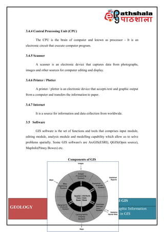
SlideShare a Scribd company logo
GEOLOGY
Paper: Remote Sensing and GIS
Module: Concepts of Geographic Information
System (GIS); include errors in GIS
Subject Geology
Paper No and Title Remote Sensing and GIS
Module No and Title
Concepts of Geographic Information System (GIS); include
errors in GIS
Module Tag RS & GIS XXII
Principal Investigator Co-Principal Investigator Co-Principal Investigator
Prof. Talat Ahmad
Vice-Chancellor
Jamia Millia Islamia
Delhi
Prof. Devesh K Sinha
Department of Geology
University of Delhi
Delhi
Prof. P. P. Chakraborty
Department of Geology
University of Delhi
Delhi
Paper Coordinator Content Writer Reviewer
Dr. Atiqur Rahman
Department of Geography,
Faculty of Natural Sciences,
Jamia Millia Islamia
Delhi
Dr. Asif
Department of Geography,
Faculty of Natural Sciences,
Jamia Millia Islamia
Delhi
Dr. Atiqur Rahman
Department of Geography,
Faculty of Natural Sciences,
Jamia Millia Islamia
Delhi
GEOLOGY
Paper: Remote Sensing and GIS
Module: Concepts of Geographic Information
System (GIS); include errors in GIS
1. Introduction
The acronym GIS stands for Geographic Information System or Science
where G stands for any Geographical features with reference to a particular location
on the earth surface. I stand for Information about geographic features stored in
tabular form and S stands for System which consists of software, hardware and
geographically referenced data.
It was Roger Tomlinson who used the term Canada Geographic Information
System (CGIS) first time in 1960s during his work with the Canada Land Inventory
(CLI). GIS is a modern tool of ancient Cartography and its most common product is
maps. Advance technology and huge Geographic data are responsible for today's
colourful, advanced and interactive maps. GIS is a special tool that is integrated with
data and information which help us to understand and relate to the "what," "when,"
"how," and "why" of the World by answering "where." The development of GIS
have been four distinct phases, i) Few individuals wanted to use GIS as tool to give
shape and direction of future research in early 1960s to mid 1970s. ii) National
agencies saw the use of GIS technologies to focus on the development in 1970s to
early 1980s. iii) In 1982 to late 1980s the development and exploitation of
commercial place using GIS, final phase started late 1980s has aim to improving the
usability of GIS technology by making facilities.
Effective decisions have been always dependent on information. Spatial
information is quite complex to answer the question of - Where is What its ancient
used for navigation and find the accurate position of physical features on earth. GIS
was used to identify the changes on the same theme maps made on different time
period. The basic concept of GIS was to determine the spatial relationship among
features on an area through maps. It is a geographically oriented computer
technology that is comprises of both spatial and non-spatial data, which allows the
powerful analysis of big area frequently in low cost. Before digital era this has been
done using manual processing and production of paper maps from analogue datasets.
GEOLOGY
Paper: Remote Sensing and GIS
Module: Concepts of Geographic Information
System (GIS); include errors in GIS
Use of computers and modern technologies has led to increase the handling of
spatial data in all aspects.
Peoples are used computers and computerized information system for most
activities in today's life because computerization has potential to made
communication, analysis and make decisions easily. Several of our decisions depend
on our surroundings environment and need related information about specific places
on the Earth's surface. Information related to specific places on the Earth's surface
and our surroundings environment are used in several of our decisions. Such
information is called geographical because it is use to distinguish places and to make
decisions that are congruous for the concerned location.
GIS has ability to collect information from various sources to depict the
spatial relationship among features on earth surface. GIS data can be viewed in three
different ways as follows:
(i) Database view: The non-spatial data (tabular data or attribute) comes
under this GIS data view and it is able to store information in the form of table
associated to spatial features.
(ii) Map view: It is very essential part of GIS because it allows user to
visualize the pattern and understand the relationship among data sets. Maps are very
important tool that depicted the features and their relationship on the earth's surface
and shows the relationship among these features on maps.
(iii) Layer view: Here, the GIS data represent in various layers. One set of
data is displayed "on top of" another to show spatial pattern and relationship on map.
For example, temperature at any location can show up in the first layer and pressure
of same location can be show up in the second layer.
GIS is the art or science, concerned with systematic processing of data using
computers to solve spatial problems. GIS is a computer aided technique
encompasses software, hardware and data that is used to store, retrieve, manipulate,
manage, analyse and output of geographically referenced spatial data. With the help
GEOLOGY
Paper: Remote Sensing and GIS
Module: Concepts of Geographic Information
System (GIS); include errors in GIS
of GIS we can compare the positions of different objects on earth surface in order to
determine their relationship to each other. For example, the utility and services map
of an area including sites that produce good healthcare services like hospitals and
sites where less healthcare services. The information used in GIS is based on
location such as coordinates (latitude and longitude), address and PIN code etc.
Attribute information are also used in GIS that describe the characteristics of
features available in spatial database such as income, population and age. GIS
generate data from various spatial (satellite, aerial photographs and maps) and non-
spatial (Attribute and tabular) sources align and keep it together because data have
different scales and projections.
A scale is defined by the ratio of map distance and corresponding distance on
earth surface. Thus, projection enables the user to transfer information from 3
dimensional earth surfaces to 2 dimensional flat piece of paper. GIS used data from
various sources that were prepared in different projections and keep it together so
that all information can be appeared by common projection.
2. Understanding GIS: Common definitions
GIS is “a powerful set of tools for storing and retrieving at will, transforming
and displaying spatial data from the real world for a particular set of purposes“
(Burrough, 1986). "A geographic information system is a special case of information
systems where the database consists of observations on spatially distributed features,
activities or events, which are definable in space as points, lines, or areas. A
geographic information system manipulates data about these points, lines, and areas
to retrieve data for ad hoc queries and analyses" (Dueker, 1979). Maguire (1991)
defines GIS in the following manner:
 Process-/function-oriented - emphasises the information handling capabilities
of GIS (e.g., storage, retrieval, manipulation, and display of geographic
data);
GEOLOGY
Paper: Remote Sensing and GIS
Module: Concepts of Geographic Information
System (GIS); include errors in GIS
 Application - divides information systems according to the problems they
seeks to address (e.g., soil, land, and planning information system);
 Toolbox - emphasises the generic aspects of GIS as a toolbox to manipulate
spatial data;
 Database - regards GIS as a database system, reflecting the influence of
database theory and practice on GIS.
3. GIS Workflow
GIS Workflow depends on the following components:
3.1 User
It includes technical experts, managers and administrators who are
responsible for the day-to-day operations in GIS. Peoples from various disciplines
are being used GIS as a tool that allow them to perform their task more accurately.
For example town planner use GIS in town planning and academician use GIS to
teach and research etc.
3.2 Information
It is most important and expensive component of GIS that can be divided
into following two categories.
3.2.1 Spatial data
It is the data which is available in raster or image form that comprises
geographic location, shape, size, orientation and boundaries of features present on
earth surface such as lake, forest, mountain, town boundary etc. It is also known as
geospatial data.
3.2.2 Tabular data
GEOLOGY
Paper: Remote Sensing and GIS
Module: Concepts of Geographic Information
System (GIS); include errors in GIS
It is also known as non-spatial or attribute data. It has information related to
spatial features that is described in details for example India is divided into various
state, natural regions, religion and population etc. are tabular data that is arranged in
tabular form because these variables are independent of the India's location.
3.3 Methodology / Procedure
Methodology is the detail workflow that includes data preparation, data
manipulation, data analysis and final result. Procedure is the defined way that is
used to analyse the data and produce better result. It includes guidelines, standard
and protocol that is very important component for project work of an organisation.
3.4 Hardware
It is play an important role in GIS environment because GIS work depend on
huge datasets especially on satellite images that need more memory and fast
processing for data manipulation and data analysis. Some important hardware
component that used in GIS is given below.
3.4.1 Visual Display Unit (VDU) / Monitor
It is an electronic device that is used to see the information comes out from
computers.
3.4.2 Keyboard
It is a device which is being used for instruction, commands and data entry.
Keyboard is used to entered attribute data and manual digitizing is used for entering
spatial information from maps and images in GIS.
3.4.3 Mouse
It is a wonderful pointing device used for data selection, editing, zoom in and
zoom out and creating the spatial data base in GIS.
GEOLOGY
Paper: Remote Sensing and GIS
Module: Concepts of Geographic Information
System (GIS); include errors in GIS
3.4.4 Central Processing Unit (CPU)
The CPU is the brain of computer and known as processor - It is an
electronic circuit that execute computer program.
3.4.5 Scanner
A scanner is an electronic device that captures data from photographs,
images and other sources for computer editing and display.
3.4.6 Printer / Plotter
A printer / plotter is an electronic device that accepts text and graphic output
from a computer and transfers the information to paper.
3.4.7 Internet
It is a source for information and data collection from worldwide.
3.5 Software
GIS software is the set of functions and tools that comprises input module,
editing module, analysis module and modelling capability which allow us to solve
problems spatially. Some GIS software's are ArcGIS(ESRI), QGIS(Open source),
MapInfo(Pitney Bowes) etc.
Components of GIS
GEOLOGY
Paper: Remote Sensing and GIS
Module: Concepts of Geographic Information
System (GIS); include errors in GIS
Source: Schuurman (2004)
GIS Workflow
4. Errors in GIS
The errors in data and its impact on GIS analysis had not been considered in
recent years. GIS experts started to accept errors and inaccuracy that can disturb the
quality of many GIS projects in the last decades. Understanding the GIS error is
important for spatial analysis to ensuring that datasets meets a minimum threshold
for accuracy. The saying, “Garbage in, garbage out” applies all to well when data
that is inaccurate, imprecise, or full of errors is used during analysis. Many data sets
related to same geographical area are being used to perform analysis and
manipulation in GIS environment. When we collected GIS data from field it contain
some errors and at this stage user need to aware and understand the limitation of
error in data that can be used in GIS.
Accuracy of data is dependent on the degree or closeness to which the
feature on a map matches the values on the ground. In GIS accuracy cab be
People
Data Hardware
Method Software
GIS
GEOLOGY
Paper: Remote Sensing and GIS
Module: Concepts of Geographic Information
System (GIS); include errors in GIS
associated with geographic location, geometry of feature and attribute data.
Geographic data used in GIS are not error free. Accuracy of features in GIS should
be attached with their associated data. Data (Spatial and non-spatial) in GIS
environment contain some error. These errors are classified into following manners.
4.1 Pre-processing errors
Before start working on any GIS project, the main issue is that how to
incorporate data in GIS because this is the process of most time consuming and risk
of maximum error in data. Pre-processing errors are those which are generated
before data processing in GIS environment are listed below;
4.1.1 Data reliability
It is decreases with data age; data are less reliable with increasing gap
between data acquisition and data usage. The age of data is another source of error.
The information may have changed with increasing age of data.
4.1.2 Scale
It is an error in GIS, depending on the usage of data at different scale. GIS
user need to adapt the scale of work to the specified need in their project.
4.1.3 Density of data
It must be dense because sparsely distributed data is less reliable. GIS users
should always be mindful when using old data and the lack of currency to that data
before using it for contemporary analysis.
4.1.4 Seamless data
All data must be in same unit and projection system.
4.1.5 Inaccuracy in tabular data
It is linked to spatial features may be imprecise. Imprecise data may result
from error of many kinds. Precise data associated to spatial features describes
GEOLOGY
Paper: Remote Sensing and GIS
Module: Concepts of Geographic Information
System (GIS); include errors in GIS
features in detailed. For example, A precise description of climate at specific area
include temperature, pressure, rainfall and many others characteristics. Attributes are
attached in correct way so that contents are matched correctly.
4.2 Processing errors
It is very difficult to detect by user. It is harmful error that occur in many
ways because they can occur in various data sets and being manipulated in GIS.
These errors are moved through processing and increase with every manipulation.
Processing errors are those which are occur at the time of data processing in GIS
domain like;
4.2.1 Numerical errors
The performance of computers are vary from one to another for
mathematical operations and produce valuable results for the same problem.
4.2.2 Data formatting
Changes scale, projection, export / import, convert one format to another
format etc. are few examples of data formatting errors.
4.2.3 Digitization errors
It is the error which is produced by digitizing the features like i) location
errors which is related to location of map features on digitized map ii)Topological
errors, wrong manipulation of data and topological analysis may cause of logical
errors. It includes undershoot-when two arc do not meet perfectly at a node,
overshoot- when two arc overextended to each other.
4.2.4 Data manipulation errors
Some errors are occur at the time of producing maps used as GIS sources
like Computations, geodetic network, data editing, enlarging/reducing and
redrawing are some basic errors. Data conversion from raster to vector and vector to
GEOLOGY
Paper: Remote Sensing and GIS
Module: Concepts of Geographic Information
System (GIS); include errors in GIS
raster, spatial analysis, generalization and interpolation etc. are few errors comes
under this category.
Summary:
A Geographic Information System (GIS) is incorporated with hardware,
software and data. The basic concept of GIS was to determine the spatial
relationship among features on an area through maps. It is a geographically oriented
computer technology that is comprises of both spatial and non spatial data, which
allows the powerful analysis of big area frequently in low cost. Recently GIS is
expanding rapidly and used by various discipline of people and organisation for
wide variety of applications. Spatial analysis, database and the map views are the
main views of GIS. Peoples are used computers and computerized information
system for most activities in today's life because computerization has potential to
made communication, analysis and make decisions easily. Several of our decisions
depend on our surroundings environment and need related information about
specific places on the Earth's surface.
GIS work flow depends on various components e.g. User, information,
methodology/procedure, hardware and software. GIS experts started to accept errors
and inaccuracy that can disturb the quality of many GIS projects in the last decades.
Understanding the GIS error is important for spatial analysis to ensuring that
datasets meets a minimum threshold for accuracy. Many data sets related to same
geographical area are being used to perform analysis and manipulation in GIS
environment. When we collected GIS data from field it contain some errors and at
this stage user need to aware and understand the limitation of error in data that can
be used in GIS. Accuracy of data is dependent on the degree or closeness to which
the feature on a map matches the values on the ground. In GIS accuracy cab be
associated with geographic location, geometry of feature and attribute data. Data in
GIS environment contain some error. These errors are classified into two manners,
(i) Pre-processing errors and (ii) processing errors.
GEOLOGY
Paper: Remote Sensing and GIS
Module: Concepts of Geographic Information
System (GIS); include errors in GIS
Frequently Asked Questions (FAQs):
1. What is Geographical Information System (GIS) ?
GIS is a computer aided technique encompasses software, hardware and data
that is used to store, retrieve, manipulate, manage, analyse and output of
geographically referenced spatial data.
2. What are the components of GIS?
A GIS integrates several key components e.g. people, hardware, software,
data and methods. Hardware is the computer (CPU, Memory, Keyboard, Mouse,
scanner etc.) on which a GIS operates. GIS software provide the functionality to
analyze and display the geographic information. GIS data is an important component
of GIS and its included both spatial and non-spatial data. A successful GIS operates
depends on good method and plan. People who manages the system and develop
plan for applying GIS to solve the real World problems.
3. What type of data used in GIS?
In GIS broadly two types of data are being used which are mentions below
(i) Spatial data: It is the data which is available in raster or image form that
comprises geographic location, shape, size, orientation and boundaries of features
present on earth surface such as lake, forest, mountain, town boundary etc. It is also
known as geospatial data.
(ii) Non-spatial data or Tabular data: It is also known as attribute data. It has
information related to spatial features that is described in details for example India is
divided into various state, natural regions, religion and population etc. are tabular
data that is arranged in tabular form because these variables are independent of the
India's location.
GEOLOGY
Paper: Remote Sensing and GIS
Module: Concepts of Geographic Information
System (GIS); include errors in GIS
4. How many types of errors in GIS?
The errors in data and its impact on GIS analysis had not been considered in
recent years. GIS experts started to accept errors and inaccuracy that can disturb the
quality of many GIS projects in the last decades. Understanding the GIS error is
important for spatial analysis to ensuring that datasets meets a minimum threshold
for accuracy. There are two basic types of errors in GIS are mention below
(i) Pre-processing errors: Pre-processing errors are those which are generated
before data processing in GIS environment are listed below;
(a) Data reliability
(b) Scale
(c) Density of data
(d) Seamless data
(ii) Processing errors: Processing errors are those which are occur at the time of
data processing in GIS domain like;
(a) Numerical errors
(b) Data formatting
(c) Digitization errors
(d) Data manipulation errors
5. Why GIS is important?
There are many reasons to why GIS is important, here are few. It provides
information to planners for decision making to solve complex geospatial
questions. It integrates both spatial and non-spatial data in a single framework and
provide spatial relationships within data that might not be obvious outside of a GIS.
Multiple Choice Questions (Quiz)
1. What does the abbreviation "GIS" stand for?
(i) Geoscience Interpolation software
GEOLOGY
Paper: Remote Sensing and GIS
Module: Concepts of Geographic Information
System (GIS); include errors in GIS
(ii) Geological Information System
(iii) Geographical Information System
(iv) Geographic Interpretation System
2. A computerised system for the capture, storage, retrieval, analysis and display of
spatial data is known as
(i) Remote sensing
(ii) a GPS
(iii) a GIS
(iv) None of the above
3. Which type of data is used in GIS
(i) Spatial data
(ii) Non-spatial data
(iii) both (i) and (ii)
(iv) None of above
4. Which is not a pre-processing error in GIS
(i) Scale error
(ii) Seamless data error
(iii) Digitization error
(iv) Data reliability
5. Which is not a GIS software
(i) Erdas Imagine
(ii) Quantum GIS
(iii) ArcGIS
(iv) MapInfo
GEOLOGY
Paper: Remote Sensing and GIS
Module: Concepts of Geographic Information
System (GIS); include errors in GIS
Suggested Readings:
1. Lo, Char P., & Yeung, Albert K. W. (2006). Concepts and Techniques of
Geographic Information System, 2nd
Edn. Pearson Education. ISBN:
013149502X, 978-0131495029.
2. Heywood, I., Cornelius, S. & Carver, S. (2011). An Introduction to
Geographical Information Systems, 4th
Edn. Prentice Hall. ISBN:
027372259X, 978-0273722595.
3. Burrough, Peter A., & McDonnell, Rachael, A. (1998). Principles of
Geographical Information Systems, 2nd
Edn. OUP Oxford. ISBN:
0198233655, 978-0198233657.
4. Sahu, Kali C. (2007). Textbook of Remote Sensing and Geographical
Information. Atlantic Publications, New Delhi. ISBN: 8126909099, 978-
8126909094.
5. Bernhardsen, T. (2002). Geographic Information System: An Introduction,
3rd
Edn. John Wiley & Sons, New York. ISBN: 0471419680, 978-
0471419686.
6. Chang, Kang-tsung (2017), Introduction to Geographical Information
Systems, 4th
Edn., McGraw Hill Education, India. ISBN: 0070658986, 978-
0070658981.

More Related Content

Similar to 1505382049E-TextConceptsofGIS(includeerrorsinGIS.pdf

Basic of gis concept and theories
Basic of gis concept and theoriesBasic of gis concept and theories
Basic of gis concept and theories
Mohsin Siddique
 
Introduction to gis
Introduction to gisIntroduction to gis
Introduction to gis
Habibur Rahman
 
Introduction to GIS
Introduction to GISIntroduction to GIS
Introduction to GIS
Obaidur Rahaman Ovi
 
EVS G.I.S CONCEPTS OF SCIENCE PPT.pptx
EVS  G.I.S CONCEPTS  OF SCIENCE PPT.pptxEVS  G.I.S CONCEPTS  OF SCIENCE PPT.pptx
EVS G.I.S CONCEPTS OF SCIENCE PPT.pptx
UMANJUNATH
 
Overview of gis new
Overview of gis newOverview of gis new
Overview of gis new
Kanagiri S Prasad
 
GIS.INTRODUCTION TO GIS PACKAGES &GEOGRAPHIIC ANALYSIS
GIS.INTRODUCTION TO GIS PACKAGES &GEOGRAPHIIC ANALYSISGIS.INTRODUCTION TO GIS PACKAGES &GEOGRAPHIIC ANALYSIS
GIS.INTRODUCTION TO GIS PACKAGES &GEOGRAPHIIC ANALYSIS
TessaRaju
 
Gis
GisGis
Gis
GisGis
Geographical Information System By Zewde Alemayehu Tilahun.pptx
Geographical Information System By Zewde Alemayehu Tilahun.pptxGeographical Information System By Zewde Alemayehu Tilahun.pptx
Geographical Information System By Zewde Alemayehu Tilahun.pptx
zewde alemayehu
 
Geographical information system by zewde alemayehu tilahun
Geographical information system by zewde alemayehu tilahunGeographical information system by zewde alemayehu tilahun
Geographical information system by zewde alemayehu tilahun
zewde alemayehu
 
introduction to GIS
introduction to GIS introduction to GIS
introduction to GIS
niazali15CRP92
 
1_GEOGRAPHIC INFORMATION SYSTEMSTEM.pptx
1_GEOGRAPHIC INFORMATION SYSTEMSTEM.pptx1_GEOGRAPHIC INFORMATION SYSTEMSTEM.pptx
1_GEOGRAPHIC INFORMATION SYSTEMSTEM.pptx
LaleanePale
 
UNIt 6.pptxkkkkkkkkkkkkkkkkkkkkkkkkkkkkkkkkkkkkk
UNIt 6.pptxkkkkkkkkkkkkkkkkkkkkkkkkkkkkkkkkkkkkkUNIt 6.pptxkkkkkkkkkkkkkkkkkkkkkkkkkkkkkkkkkkkkk
UNIt 6.pptxkkkkkkkkkkkkkkkkkkkkkkkkkkkkkkkkkkkkk
Mrunmayee Manjari
 
Geomatics
Geomatics Geomatics
Geomatics
Rohit Bisht
 
Intro of geographic info system
Intro of geographic info systemIntro of geographic info system
Intro of geographic info system
Janak Parmar
 
Learning assignment on geographic information system
Learning assignment on geographic information systemLearning assignment on geographic information system
Learning assignment on geographic information system
Muhammad Tahir Mehmood
 
GIS
GISGIS
Introduction to GIS
Introduction to GISIntroduction to GIS
Introduction to GIS
KU Leuven
 
2-200305220204.pdf
2-200305220204.pdf2-200305220204.pdf
2-200305220204.pdf
IIT Bombay
 
Intro to GIS and Remote Sensing
Intro to GIS and Remote SensingIntro to GIS and Remote Sensing
Intro to GIS and Remote Sensing
John Reiser
 

Similar to 1505382049E-TextConceptsofGIS(includeerrorsinGIS.pdf (20)

Basic of gis concept and theories
Basic of gis concept and theoriesBasic of gis concept and theories
Basic of gis concept and theories
 
Introduction to gis
Introduction to gisIntroduction to gis
Introduction to gis
 
Introduction to GIS
Introduction to GISIntroduction to GIS
Introduction to GIS
 
EVS G.I.S CONCEPTS OF SCIENCE PPT.pptx
EVS  G.I.S CONCEPTS  OF SCIENCE PPT.pptxEVS  G.I.S CONCEPTS  OF SCIENCE PPT.pptx
EVS G.I.S CONCEPTS OF SCIENCE PPT.pptx
 
Overview of gis new
Overview of gis newOverview of gis new
Overview of gis new
 
GIS.INTRODUCTION TO GIS PACKAGES &GEOGRAPHIIC ANALYSIS
GIS.INTRODUCTION TO GIS PACKAGES &GEOGRAPHIIC ANALYSISGIS.INTRODUCTION TO GIS PACKAGES &GEOGRAPHIIC ANALYSIS
GIS.INTRODUCTION TO GIS PACKAGES &GEOGRAPHIIC ANALYSIS
 
Gis
GisGis
Gis
 
Gis
GisGis
Gis
 
Geographical Information System By Zewde Alemayehu Tilahun.pptx
Geographical Information System By Zewde Alemayehu Tilahun.pptxGeographical Information System By Zewde Alemayehu Tilahun.pptx
Geographical Information System By Zewde Alemayehu Tilahun.pptx
 
Geographical information system by zewde alemayehu tilahun
Geographical information system by zewde alemayehu tilahunGeographical information system by zewde alemayehu tilahun
Geographical information system by zewde alemayehu tilahun
 
introduction to GIS
introduction to GIS introduction to GIS
introduction to GIS
 
1_GEOGRAPHIC INFORMATION SYSTEMSTEM.pptx
1_GEOGRAPHIC INFORMATION SYSTEMSTEM.pptx1_GEOGRAPHIC INFORMATION SYSTEMSTEM.pptx
1_GEOGRAPHIC INFORMATION SYSTEMSTEM.pptx
 
UNIt 6.pptxkkkkkkkkkkkkkkkkkkkkkkkkkkkkkkkkkkkkk
UNIt 6.pptxkkkkkkkkkkkkkkkkkkkkkkkkkkkkkkkkkkkkkUNIt 6.pptxkkkkkkkkkkkkkkkkkkkkkkkkkkkkkkkkkkkkk
UNIt 6.pptxkkkkkkkkkkkkkkkkkkkkkkkkkkkkkkkkkkkkk
 
Geomatics
Geomatics Geomatics
Geomatics
 
Intro of geographic info system
Intro of geographic info systemIntro of geographic info system
Intro of geographic info system
 
Learning assignment on geographic information system
Learning assignment on geographic information systemLearning assignment on geographic information system
Learning assignment on geographic information system
 
GIS
GISGIS
GIS
 
Introduction to GIS
Introduction to GISIntroduction to GIS
Introduction to GIS
 
2-200305220204.pdf
2-200305220204.pdf2-200305220204.pdf
2-200305220204.pdf
 
Intro to GIS and Remote Sensing
Intro to GIS and Remote SensingIntro to GIS and Remote Sensing
Intro to GIS and Remote Sensing
 

Recently uploaded

BIOLOGY NATIONAL EXAMINATION COUNCIL (NECO) 2024 PRACTICAL MANUAL.pptx
BIOLOGY NATIONAL EXAMINATION COUNCIL (NECO) 2024 PRACTICAL MANUAL.pptxBIOLOGY NATIONAL EXAMINATION COUNCIL (NECO) 2024 PRACTICAL MANUAL.pptx
BIOLOGY NATIONAL EXAMINATION COUNCIL (NECO) 2024 PRACTICAL MANUAL.pptx
RidwanHassanYusuf
 
Juneteenth Freedom Day 2024 David Douglas School District
Juneteenth Freedom Day 2024 David Douglas School DistrictJuneteenth Freedom Day 2024 David Douglas School District
Juneteenth Freedom Day 2024 David Douglas School District
David Douglas School District
 
RHEOLOGY Physical pharmaceutics-II notes for B.pharm 4th sem students
RHEOLOGY Physical pharmaceutics-II notes for B.pharm 4th sem studentsRHEOLOGY Physical pharmaceutics-II notes for B.pharm 4th sem students
RHEOLOGY Physical pharmaceutics-II notes for B.pharm 4th sem students
Himanshu Rai
 
Standardized tool for Intelligence test.
Standardized tool for Intelligence test.Standardized tool for Intelligence test.
Standardized tool for Intelligence test.
deepaannamalai16
 
Oliver Asks for More by Charles Dickens (9)
Oliver Asks for More by Charles Dickens (9)Oliver Asks for More by Charles Dickens (9)
Oliver Asks for More by Charles Dickens (9)
nitinpv4ai
 
How to Fix [Errno 98] address already in use
How to Fix [Errno 98] address already in useHow to Fix [Errno 98] address already in use
How to Fix [Errno 98] address already in use
Celine George
 
CHUYÊN ĐỀ ÔN TẬP VÀ PHÁT TRIỂN CÂU HỎI TRONG ĐỀ MINH HỌA THI TỐT NGHIỆP THPT ...
CHUYÊN ĐỀ ÔN TẬP VÀ PHÁT TRIỂN CÂU HỎI TRONG ĐỀ MINH HỌA THI TỐT NGHIỆP THPT ...CHUYÊN ĐỀ ÔN TẬP VÀ PHÁT TRIỂN CÂU HỎI TRONG ĐỀ MINH HỌA THI TỐT NGHIỆP THPT ...
CHUYÊN ĐỀ ÔN TẬP VÀ PHÁT TRIỂN CÂU HỎI TRONG ĐỀ MINH HỌA THI TỐT NGHIỆP THPT ...
Nguyen Thanh Tu Collection
 
skeleton System.pdf (skeleton system wow)
skeleton System.pdf (skeleton system wow)skeleton System.pdf (skeleton system wow)
skeleton System.pdf (skeleton system wow)
Mohammad Al-Dhahabi
 
Electric Fetus - Record Store Scavenger Hunt
Electric Fetus - Record Store Scavenger HuntElectric Fetus - Record Store Scavenger Hunt
Electric Fetus - Record Store Scavenger Hunt
RamseyBerglund
 
Pharmaceutics Pharmaceuticals best of brub
Pharmaceutics Pharmaceuticals best of brubPharmaceutics Pharmaceuticals best of brub
Pharmaceutics Pharmaceuticals best of brub
danielkiash986
 
How to Download & Install Module From the Odoo App Store in Odoo 17
How to Download & Install Module From the Odoo App Store in Odoo 17How to Download & Install Module From the Odoo App Store in Odoo 17
How to Download & Install Module From the Odoo App Store in Odoo 17
Celine George
 
Temple of Asclepius in Thrace. Excavation results
Temple of Asclepius in Thrace. Excavation resultsTemple of Asclepius in Thrace. Excavation results
Temple of Asclepius in Thrace. Excavation results
Krassimira Luka
 
Elevate Your Nonprofit's Online Presence_ A Guide to Effective SEO Strategies...
Elevate Your Nonprofit's Online Presence_ A Guide to Effective SEO Strategies...Elevate Your Nonprofit's Online Presence_ A Guide to Effective SEO Strategies...
Elevate Your Nonprofit's Online Presence_ A Guide to Effective SEO Strategies...
TechSoup
 
NEWSPAPERS - QUESTION 1 - REVISION POWERPOINT.pptx
NEWSPAPERS - QUESTION 1 - REVISION POWERPOINT.pptxNEWSPAPERS - QUESTION 1 - REVISION POWERPOINT.pptx
NEWSPAPERS - QUESTION 1 - REVISION POWERPOINT.pptx
iammrhaywood
 
RESULTS OF THE EVALUATION QUESTIONNAIRE.pptx
RESULTS OF THE EVALUATION QUESTIONNAIRE.pptxRESULTS OF THE EVALUATION QUESTIONNAIRE.pptx
RESULTS OF THE EVALUATION QUESTIONNAIRE.pptx
zuzanka
 
How Barcodes Can Be Leveraged Within Odoo 17
How Barcodes Can Be Leveraged Within Odoo 17How Barcodes Can Be Leveraged Within Odoo 17
How Barcodes Can Be Leveraged Within Odoo 17
Celine George
 
Geography as a Discipline Chapter 1 __ Class 11 Geography NCERT _ Class Notes...
Geography as a Discipline Chapter 1 __ Class 11 Geography NCERT _ Class Notes...Geography as a Discipline Chapter 1 __ Class 11 Geography NCERT _ Class Notes...
Geography as a Discipline Chapter 1 __ Class 11 Geography NCERT _ Class Notes...
ImMuslim
 
NIPER 2024 MEMORY BASED QUESTIONS.ANSWERS TO NIPER 2024 QUESTIONS.NIPER JEE 2...
NIPER 2024 MEMORY BASED QUESTIONS.ANSWERS TO NIPER 2024 QUESTIONS.NIPER JEE 2...NIPER 2024 MEMORY BASED QUESTIONS.ANSWERS TO NIPER 2024 QUESTIONS.NIPER JEE 2...
NIPER 2024 MEMORY BASED QUESTIONS.ANSWERS TO NIPER 2024 QUESTIONS.NIPER JEE 2...
Payaamvohra1
 
Skimbleshanks-The-Railway-Cat by T S Eliot
Skimbleshanks-The-Railway-Cat by T S EliotSkimbleshanks-The-Railway-Cat by T S Eliot
Skimbleshanks-The-Railway-Cat by T S Eliot
nitinpv4ai
 
Andreas Schleicher presents PISA 2022 Volume III - Creative Thinking - 18 Jun...
Andreas Schleicher presents PISA 2022 Volume III - Creative Thinking - 18 Jun...Andreas Schleicher presents PISA 2022 Volume III - Creative Thinking - 18 Jun...
Andreas Schleicher presents PISA 2022 Volume III - Creative Thinking - 18 Jun...
EduSkills OECD
 

Recently uploaded (20)

BIOLOGY NATIONAL EXAMINATION COUNCIL (NECO) 2024 PRACTICAL MANUAL.pptx
BIOLOGY NATIONAL EXAMINATION COUNCIL (NECO) 2024 PRACTICAL MANUAL.pptxBIOLOGY NATIONAL EXAMINATION COUNCIL (NECO) 2024 PRACTICAL MANUAL.pptx
BIOLOGY NATIONAL EXAMINATION COUNCIL (NECO) 2024 PRACTICAL MANUAL.pptx
 
Juneteenth Freedom Day 2024 David Douglas School District
Juneteenth Freedom Day 2024 David Douglas School DistrictJuneteenth Freedom Day 2024 David Douglas School District
Juneteenth Freedom Day 2024 David Douglas School District
 
RHEOLOGY Physical pharmaceutics-II notes for B.pharm 4th sem students
RHEOLOGY Physical pharmaceutics-II notes for B.pharm 4th sem studentsRHEOLOGY Physical pharmaceutics-II notes for B.pharm 4th sem students
RHEOLOGY Physical pharmaceutics-II notes for B.pharm 4th sem students
 
Standardized tool for Intelligence test.
Standardized tool for Intelligence test.Standardized tool for Intelligence test.
Standardized tool for Intelligence test.
 
Oliver Asks for More by Charles Dickens (9)
Oliver Asks for More by Charles Dickens (9)Oliver Asks for More by Charles Dickens (9)
Oliver Asks for More by Charles Dickens (9)
 
How to Fix [Errno 98] address already in use
How to Fix [Errno 98] address already in useHow to Fix [Errno 98] address already in use
How to Fix [Errno 98] address already in use
 
CHUYÊN ĐỀ ÔN TẬP VÀ PHÁT TRIỂN CÂU HỎI TRONG ĐỀ MINH HỌA THI TỐT NGHIỆP THPT ...
CHUYÊN ĐỀ ÔN TẬP VÀ PHÁT TRIỂN CÂU HỎI TRONG ĐỀ MINH HỌA THI TỐT NGHIỆP THPT ...CHUYÊN ĐỀ ÔN TẬP VÀ PHÁT TRIỂN CÂU HỎI TRONG ĐỀ MINH HỌA THI TỐT NGHIỆP THPT ...
CHUYÊN ĐỀ ÔN TẬP VÀ PHÁT TRIỂN CÂU HỎI TRONG ĐỀ MINH HỌA THI TỐT NGHIỆP THPT ...
 
skeleton System.pdf (skeleton system wow)
skeleton System.pdf (skeleton system wow)skeleton System.pdf (skeleton system wow)
skeleton System.pdf (skeleton system wow)
 
Electric Fetus - Record Store Scavenger Hunt
Electric Fetus - Record Store Scavenger HuntElectric Fetus - Record Store Scavenger Hunt
Electric Fetus - Record Store Scavenger Hunt
 
Pharmaceutics Pharmaceuticals best of brub
Pharmaceutics Pharmaceuticals best of brubPharmaceutics Pharmaceuticals best of brub
Pharmaceutics Pharmaceuticals best of brub
 
How to Download & Install Module From the Odoo App Store in Odoo 17
How to Download & Install Module From the Odoo App Store in Odoo 17How to Download & Install Module From the Odoo App Store in Odoo 17
How to Download & Install Module From the Odoo App Store in Odoo 17
 
Temple of Asclepius in Thrace. Excavation results
Temple of Asclepius in Thrace. Excavation resultsTemple of Asclepius in Thrace. Excavation results
Temple of Asclepius in Thrace. Excavation results
 
Elevate Your Nonprofit's Online Presence_ A Guide to Effective SEO Strategies...
Elevate Your Nonprofit's Online Presence_ A Guide to Effective SEO Strategies...Elevate Your Nonprofit's Online Presence_ A Guide to Effective SEO Strategies...
Elevate Your Nonprofit's Online Presence_ A Guide to Effective SEO Strategies...
 
NEWSPAPERS - QUESTION 1 - REVISION POWERPOINT.pptx
NEWSPAPERS - QUESTION 1 - REVISION POWERPOINT.pptxNEWSPAPERS - QUESTION 1 - REVISION POWERPOINT.pptx
NEWSPAPERS - QUESTION 1 - REVISION POWERPOINT.pptx
 
RESULTS OF THE EVALUATION QUESTIONNAIRE.pptx
RESULTS OF THE EVALUATION QUESTIONNAIRE.pptxRESULTS OF THE EVALUATION QUESTIONNAIRE.pptx
RESULTS OF THE EVALUATION QUESTIONNAIRE.pptx
 
How Barcodes Can Be Leveraged Within Odoo 17
How Barcodes Can Be Leveraged Within Odoo 17How Barcodes Can Be Leveraged Within Odoo 17
How Barcodes Can Be Leveraged Within Odoo 17
 
Geography as a Discipline Chapter 1 __ Class 11 Geography NCERT _ Class Notes...
Geography as a Discipline Chapter 1 __ Class 11 Geography NCERT _ Class Notes...Geography as a Discipline Chapter 1 __ Class 11 Geography NCERT _ Class Notes...
Geography as a Discipline Chapter 1 __ Class 11 Geography NCERT _ Class Notes...
 
NIPER 2024 MEMORY BASED QUESTIONS.ANSWERS TO NIPER 2024 QUESTIONS.NIPER JEE 2...
NIPER 2024 MEMORY BASED QUESTIONS.ANSWERS TO NIPER 2024 QUESTIONS.NIPER JEE 2...NIPER 2024 MEMORY BASED QUESTIONS.ANSWERS TO NIPER 2024 QUESTIONS.NIPER JEE 2...
NIPER 2024 MEMORY BASED QUESTIONS.ANSWERS TO NIPER 2024 QUESTIONS.NIPER JEE 2...
 
Skimbleshanks-The-Railway-Cat by T S Eliot
Skimbleshanks-The-Railway-Cat by T S EliotSkimbleshanks-The-Railway-Cat by T S Eliot
Skimbleshanks-The-Railway-Cat by T S Eliot
 
Andreas Schleicher presents PISA 2022 Volume III - Creative Thinking - 18 Jun...
Andreas Schleicher presents PISA 2022 Volume III - Creative Thinking - 18 Jun...Andreas Schleicher presents PISA 2022 Volume III - Creative Thinking - 18 Jun...
Andreas Schleicher presents PISA 2022 Volume III - Creative Thinking - 18 Jun...
 

1505382049E-TextConceptsofGIS(includeerrorsinGIS.pdf

  • 1. GEOLOGY Paper: Remote Sensing and GIS Module: Concepts of Geographic Information System (GIS); include errors in GIS Subject Geology Paper No and Title Remote Sensing and GIS Module No and Title Concepts of Geographic Information System (GIS); include errors in GIS Module Tag RS & GIS XXII Principal Investigator Co-Principal Investigator Co-Principal Investigator Prof. Talat Ahmad Vice-Chancellor Jamia Millia Islamia Delhi Prof. Devesh K Sinha Department of Geology University of Delhi Delhi Prof. P. P. Chakraborty Department of Geology University of Delhi Delhi Paper Coordinator Content Writer Reviewer Dr. Atiqur Rahman Department of Geography, Faculty of Natural Sciences, Jamia Millia Islamia Delhi Dr. Asif Department of Geography, Faculty of Natural Sciences, Jamia Millia Islamia Delhi Dr. Atiqur Rahman Department of Geography, Faculty of Natural Sciences, Jamia Millia Islamia Delhi
  • 2. GEOLOGY Paper: Remote Sensing and GIS Module: Concepts of Geographic Information System (GIS); include errors in GIS 1. Introduction The acronym GIS stands for Geographic Information System or Science where G stands for any Geographical features with reference to a particular location on the earth surface. I stand for Information about geographic features stored in tabular form and S stands for System which consists of software, hardware and geographically referenced data. It was Roger Tomlinson who used the term Canada Geographic Information System (CGIS) first time in 1960s during his work with the Canada Land Inventory (CLI). GIS is a modern tool of ancient Cartography and its most common product is maps. Advance technology and huge Geographic data are responsible for today's colourful, advanced and interactive maps. GIS is a special tool that is integrated with data and information which help us to understand and relate to the "what," "when," "how," and "why" of the World by answering "where." The development of GIS have been four distinct phases, i) Few individuals wanted to use GIS as tool to give shape and direction of future research in early 1960s to mid 1970s. ii) National agencies saw the use of GIS technologies to focus on the development in 1970s to early 1980s. iii) In 1982 to late 1980s the development and exploitation of commercial place using GIS, final phase started late 1980s has aim to improving the usability of GIS technology by making facilities. Effective decisions have been always dependent on information. Spatial information is quite complex to answer the question of - Where is What its ancient used for navigation and find the accurate position of physical features on earth. GIS was used to identify the changes on the same theme maps made on different time period. The basic concept of GIS was to determine the spatial relationship among features on an area through maps. It is a geographically oriented computer technology that is comprises of both spatial and non-spatial data, which allows the powerful analysis of big area frequently in low cost. Before digital era this has been done using manual processing and production of paper maps from analogue datasets.
  • 3. GEOLOGY Paper: Remote Sensing and GIS Module: Concepts of Geographic Information System (GIS); include errors in GIS Use of computers and modern technologies has led to increase the handling of spatial data in all aspects. Peoples are used computers and computerized information system for most activities in today's life because computerization has potential to made communication, analysis and make decisions easily. Several of our decisions depend on our surroundings environment and need related information about specific places on the Earth's surface. Information related to specific places on the Earth's surface and our surroundings environment are used in several of our decisions. Such information is called geographical because it is use to distinguish places and to make decisions that are congruous for the concerned location. GIS has ability to collect information from various sources to depict the spatial relationship among features on earth surface. GIS data can be viewed in three different ways as follows: (i) Database view: The non-spatial data (tabular data or attribute) comes under this GIS data view and it is able to store information in the form of table associated to spatial features. (ii) Map view: It is very essential part of GIS because it allows user to visualize the pattern and understand the relationship among data sets. Maps are very important tool that depicted the features and their relationship on the earth's surface and shows the relationship among these features on maps. (iii) Layer view: Here, the GIS data represent in various layers. One set of data is displayed "on top of" another to show spatial pattern and relationship on map. For example, temperature at any location can show up in the first layer and pressure of same location can be show up in the second layer. GIS is the art or science, concerned with systematic processing of data using computers to solve spatial problems. GIS is a computer aided technique encompasses software, hardware and data that is used to store, retrieve, manipulate, manage, analyse and output of geographically referenced spatial data. With the help
  • 4. GEOLOGY Paper: Remote Sensing and GIS Module: Concepts of Geographic Information System (GIS); include errors in GIS of GIS we can compare the positions of different objects on earth surface in order to determine their relationship to each other. For example, the utility and services map of an area including sites that produce good healthcare services like hospitals and sites where less healthcare services. The information used in GIS is based on location such as coordinates (latitude and longitude), address and PIN code etc. Attribute information are also used in GIS that describe the characteristics of features available in spatial database such as income, population and age. GIS generate data from various spatial (satellite, aerial photographs and maps) and non- spatial (Attribute and tabular) sources align and keep it together because data have different scales and projections. A scale is defined by the ratio of map distance and corresponding distance on earth surface. Thus, projection enables the user to transfer information from 3 dimensional earth surfaces to 2 dimensional flat piece of paper. GIS used data from various sources that were prepared in different projections and keep it together so that all information can be appeared by common projection. 2. Understanding GIS: Common definitions GIS is “a powerful set of tools for storing and retrieving at will, transforming and displaying spatial data from the real world for a particular set of purposes“ (Burrough, 1986). "A geographic information system is a special case of information systems where the database consists of observations on spatially distributed features, activities or events, which are definable in space as points, lines, or areas. A geographic information system manipulates data about these points, lines, and areas to retrieve data for ad hoc queries and analyses" (Dueker, 1979). Maguire (1991) defines GIS in the following manner:  Process-/function-oriented - emphasises the information handling capabilities of GIS (e.g., storage, retrieval, manipulation, and display of geographic data);
  • 5. GEOLOGY Paper: Remote Sensing and GIS Module: Concepts of Geographic Information System (GIS); include errors in GIS  Application - divides information systems according to the problems they seeks to address (e.g., soil, land, and planning information system);  Toolbox - emphasises the generic aspects of GIS as a toolbox to manipulate spatial data;  Database - regards GIS as a database system, reflecting the influence of database theory and practice on GIS. 3. GIS Workflow GIS Workflow depends on the following components: 3.1 User It includes technical experts, managers and administrators who are responsible for the day-to-day operations in GIS. Peoples from various disciplines are being used GIS as a tool that allow them to perform their task more accurately. For example town planner use GIS in town planning and academician use GIS to teach and research etc. 3.2 Information It is most important and expensive component of GIS that can be divided into following two categories. 3.2.1 Spatial data It is the data which is available in raster or image form that comprises geographic location, shape, size, orientation and boundaries of features present on earth surface such as lake, forest, mountain, town boundary etc. It is also known as geospatial data. 3.2.2 Tabular data
  • 6. GEOLOGY Paper: Remote Sensing and GIS Module: Concepts of Geographic Information System (GIS); include errors in GIS It is also known as non-spatial or attribute data. It has information related to spatial features that is described in details for example India is divided into various state, natural regions, religion and population etc. are tabular data that is arranged in tabular form because these variables are independent of the India's location. 3.3 Methodology / Procedure Methodology is the detail workflow that includes data preparation, data manipulation, data analysis and final result. Procedure is the defined way that is used to analyse the data and produce better result. It includes guidelines, standard and protocol that is very important component for project work of an organisation. 3.4 Hardware It is play an important role in GIS environment because GIS work depend on huge datasets especially on satellite images that need more memory and fast processing for data manipulation and data analysis. Some important hardware component that used in GIS is given below. 3.4.1 Visual Display Unit (VDU) / Monitor It is an electronic device that is used to see the information comes out from computers. 3.4.2 Keyboard It is a device which is being used for instruction, commands and data entry. Keyboard is used to entered attribute data and manual digitizing is used for entering spatial information from maps and images in GIS. 3.4.3 Mouse It is a wonderful pointing device used for data selection, editing, zoom in and zoom out and creating the spatial data base in GIS.
  • 7. GEOLOGY Paper: Remote Sensing and GIS Module: Concepts of Geographic Information System (GIS); include errors in GIS 3.4.4 Central Processing Unit (CPU) The CPU is the brain of computer and known as processor - It is an electronic circuit that execute computer program. 3.4.5 Scanner A scanner is an electronic device that captures data from photographs, images and other sources for computer editing and display. 3.4.6 Printer / Plotter A printer / plotter is an electronic device that accepts text and graphic output from a computer and transfers the information to paper. 3.4.7 Internet It is a source for information and data collection from worldwide. 3.5 Software GIS software is the set of functions and tools that comprises input module, editing module, analysis module and modelling capability which allow us to solve problems spatially. Some GIS software's are ArcGIS(ESRI), QGIS(Open source), MapInfo(Pitney Bowes) etc. Components of GIS
  • 8. GEOLOGY Paper: Remote Sensing and GIS Module: Concepts of Geographic Information System (GIS); include errors in GIS Source: Schuurman (2004) GIS Workflow 4. Errors in GIS The errors in data and its impact on GIS analysis had not been considered in recent years. GIS experts started to accept errors and inaccuracy that can disturb the quality of many GIS projects in the last decades. Understanding the GIS error is important for spatial analysis to ensuring that datasets meets a minimum threshold for accuracy. The saying, “Garbage in, garbage out” applies all to well when data that is inaccurate, imprecise, or full of errors is used during analysis. Many data sets related to same geographical area are being used to perform analysis and manipulation in GIS environment. When we collected GIS data from field it contain some errors and at this stage user need to aware and understand the limitation of error in data that can be used in GIS. Accuracy of data is dependent on the degree or closeness to which the feature on a map matches the values on the ground. In GIS accuracy cab be People Data Hardware Method Software GIS
  • 9. GEOLOGY Paper: Remote Sensing and GIS Module: Concepts of Geographic Information System (GIS); include errors in GIS associated with geographic location, geometry of feature and attribute data. Geographic data used in GIS are not error free. Accuracy of features in GIS should be attached with their associated data. Data (Spatial and non-spatial) in GIS environment contain some error. These errors are classified into following manners. 4.1 Pre-processing errors Before start working on any GIS project, the main issue is that how to incorporate data in GIS because this is the process of most time consuming and risk of maximum error in data. Pre-processing errors are those which are generated before data processing in GIS environment are listed below; 4.1.1 Data reliability It is decreases with data age; data are less reliable with increasing gap between data acquisition and data usage. The age of data is another source of error. The information may have changed with increasing age of data. 4.1.2 Scale It is an error in GIS, depending on the usage of data at different scale. GIS user need to adapt the scale of work to the specified need in their project. 4.1.3 Density of data It must be dense because sparsely distributed data is less reliable. GIS users should always be mindful when using old data and the lack of currency to that data before using it for contemporary analysis. 4.1.4 Seamless data All data must be in same unit and projection system. 4.1.5 Inaccuracy in tabular data It is linked to spatial features may be imprecise. Imprecise data may result from error of many kinds. Precise data associated to spatial features describes
  • 10. GEOLOGY Paper: Remote Sensing and GIS Module: Concepts of Geographic Information System (GIS); include errors in GIS features in detailed. For example, A precise description of climate at specific area include temperature, pressure, rainfall and many others characteristics. Attributes are attached in correct way so that contents are matched correctly. 4.2 Processing errors It is very difficult to detect by user. It is harmful error that occur in many ways because they can occur in various data sets and being manipulated in GIS. These errors are moved through processing and increase with every manipulation. Processing errors are those which are occur at the time of data processing in GIS domain like; 4.2.1 Numerical errors The performance of computers are vary from one to another for mathematical operations and produce valuable results for the same problem. 4.2.2 Data formatting Changes scale, projection, export / import, convert one format to another format etc. are few examples of data formatting errors. 4.2.3 Digitization errors It is the error which is produced by digitizing the features like i) location errors which is related to location of map features on digitized map ii)Topological errors, wrong manipulation of data and topological analysis may cause of logical errors. It includes undershoot-when two arc do not meet perfectly at a node, overshoot- when two arc overextended to each other. 4.2.4 Data manipulation errors Some errors are occur at the time of producing maps used as GIS sources like Computations, geodetic network, data editing, enlarging/reducing and redrawing are some basic errors. Data conversion from raster to vector and vector to
  • 11. GEOLOGY Paper: Remote Sensing and GIS Module: Concepts of Geographic Information System (GIS); include errors in GIS raster, spatial analysis, generalization and interpolation etc. are few errors comes under this category. Summary: A Geographic Information System (GIS) is incorporated with hardware, software and data. The basic concept of GIS was to determine the spatial relationship among features on an area through maps. It is a geographically oriented computer technology that is comprises of both spatial and non spatial data, which allows the powerful analysis of big area frequently in low cost. Recently GIS is expanding rapidly and used by various discipline of people and organisation for wide variety of applications. Spatial analysis, database and the map views are the main views of GIS. Peoples are used computers and computerized information system for most activities in today's life because computerization has potential to made communication, analysis and make decisions easily. Several of our decisions depend on our surroundings environment and need related information about specific places on the Earth's surface. GIS work flow depends on various components e.g. User, information, methodology/procedure, hardware and software. GIS experts started to accept errors and inaccuracy that can disturb the quality of many GIS projects in the last decades. Understanding the GIS error is important for spatial analysis to ensuring that datasets meets a minimum threshold for accuracy. Many data sets related to same geographical area are being used to perform analysis and manipulation in GIS environment. When we collected GIS data from field it contain some errors and at this stage user need to aware and understand the limitation of error in data that can be used in GIS. Accuracy of data is dependent on the degree or closeness to which the feature on a map matches the values on the ground. In GIS accuracy cab be associated with geographic location, geometry of feature and attribute data. Data in GIS environment contain some error. These errors are classified into two manners, (i) Pre-processing errors and (ii) processing errors.
  • 12. GEOLOGY Paper: Remote Sensing and GIS Module: Concepts of Geographic Information System (GIS); include errors in GIS Frequently Asked Questions (FAQs): 1. What is Geographical Information System (GIS) ? GIS is a computer aided technique encompasses software, hardware and data that is used to store, retrieve, manipulate, manage, analyse and output of geographically referenced spatial data. 2. What are the components of GIS? A GIS integrates several key components e.g. people, hardware, software, data and methods. Hardware is the computer (CPU, Memory, Keyboard, Mouse, scanner etc.) on which a GIS operates. GIS software provide the functionality to analyze and display the geographic information. GIS data is an important component of GIS and its included both spatial and non-spatial data. A successful GIS operates depends on good method and plan. People who manages the system and develop plan for applying GIS to solve the real World problems. 3. What type of data used in GIS? In GIS broadly two types of data are being used which are mentions below (i) Spatial data: It is the data which is available in raster or image form that comprises geographic location, shape, size, orientation and boundaries of features present on earth surface such as lake, forest, mountain, town boundary etc. It is also known as geospatial data. (ii) Non-spatial data or Tabular data: It is also known as attribute data. It has information related to spatial features that is described in details for example India is divided into various state, natural regions, religion and population etc. are tabular data that is arranged in tabular form because these variables are independent of the India's location.
  • 13. GEOLOGY Paper: Remote Sensing and GIS Module: Concepts of Geographic Information System (GIS); include errors in GIS 4. How many types of errors in GIS? The errors in data and its impact on GIS analysis had not been considered in recent years. GIS experts started to accept errors and inaccuracy that can disturb the quality of many GIS projects in the last decades. Understanding the GIS error is important for spatial analysis to ensuring that datasets meets a minimum threshold for accuracy. There are two basic types of errors in GIS are mention below (i) Pre-processing errors: Pre-processing errors are those which are generated before data processing in GIS environment are listed below; (a) Data reliability (b) Scale (c) Density of data (d) Seamless data (ii) Processing errors: Processing errors are those which are occur at the time of data processing in GIS domain like; (a) Numerical errors (b) Data formatting (c) Digitization errors (d) Data manipulation errors 5. Why GIS is important? There are many reasons to why GIS is important, here are few. It provides information to planners for decision making to solve complex geospatial questions. It integrates both spatial and non-spatial data in a single framework and provide spatial relationships within data that might not be obvious outside of a GIS. Multiple Choice Questions (Quiz) 1. What does the abbreviation "GIS" stand for? (i) Geoscience Interpolation software
  • 14. GEOLOGY Paper: Remote Sensing and GIS Module: Concepts of Geographic Information System (GIS); include errors in GIS (ii) Geological Information System (iii) Geographical Information System (iv) Geographic Interpretation System 2. A computerised system for the capture, storage, retrieval, analysis and display of spatial data is known as (i) Remote sensing (ii) a GPS (iii) a GIS (iv) None of the above 3. Which type of data is used in GIS (i) Spatial data (ii) Non-spatial data (iii) both (i) and (ii) (iv) None of above 4. Which is not a pre-processing error in GIS (i) Scale error (ii) Seamless data error (iii) Digitization error (iv) Data reliability 5. Which is not a GIS software (i) Erdas Imagine (ii) Quantum GIS (iii) ArcGIS (iv) MapInfo
  • 15. GEOLOGY Paper: Remote Sensing and GIS Module: Concepts of Geographic Information System (GIS); include errors in GIS Suggested Readings: 1. Lo, Char P., & Yeung, Albert K. W. (2006). Concepts and Techniques of Geographic Information System, 2nd Edn. Pearson Education. ISBN: 013149502X, 978-0131495029. 2. Heywood, I., Cornelius, S. & Carver, S. (2011). An Introduction to Geographical Information Systems, 4th Edn. Prentice Hall. ISBN: 027372259X, 978-0273722595. 3. Burrough, Peter A., & McDonnell, Rachael, A. (1998). Principles of Geographical Information Systems, 2nd Edn. OUP Oxford. ISBN: 0198233655, 978-0198233657. 4. Sahu, Kali C. (2007). Textbook of Remote Sensing and Geographical Information. Atlantic Publications, New Delhi. ISBN: 8126909099, 978- 8126909094. 5. Bernhardsen, T. (2002). Geographic Information System: An Introduction, 3rd Edn. John Wiley & Sons, New York. ISBN: 0471419680, 978- 0471419686. 6. Chang, Kang-tsung (2017), Introduction to Geographical Information Systems, 4th Edn., McGraw Hill Education, India. ISBN: 0070658986, 978- 0070658981.