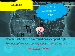
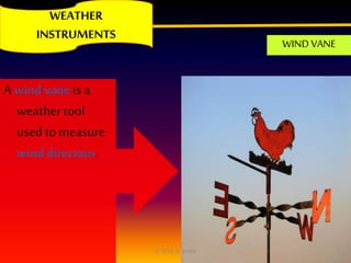
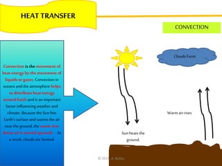
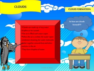
This document provides an overview of weather and climate concepts for 5th grade students. It defines weather as the daily conditions of a specific place, while climate is the average weather conditions over a long period of time, such as 10 years. The document then covers various weather phenomena like severe weather events, cloud types, heat transfer mechanisms, the water cycle, jet streams, and the reasons for seasons. Meteorologists use tools like barometers, rain gauges, anemometers and thermometers to collect weather data.
Cyclones are areas of closed, circular winds rotating clockwise in the Southern Hemisphere and counterclockwise in the Northern Hemisphere around centers of low atmospheric pressure. They form over warm ocean waters and rely on favorable wind patterns, gaining energy from the ocean. Cyclones can cause heavy rain, strong winds, storm surges, and tornadoes, resulting in impacts like flooding, erosion, mudslides and damage to lives and property. The 1999 Odisha cyclone was the strongest ever recorded in the North Indian Ocean with winds of 160 mph, killing about 10,000 people in India.
This document provides information about weather and climate in Britain. It discusses how weather is measured, including temperature, precipitation, sunshine, wind, air pressure and cloud cover. It then explains some key factors that influence Britain's climate, such as its northern latitude, the Gulf Stream and differences in land elevation. Relief and frontal rainfall, as well as convectional rainfall, are described. The document also covers climate graphs and different air masses that affect Britain.
This document discusses various factors that affect weather including temperature, wind, air pressure, and humidity. It explains how solar radiation affects different parts of the Earth unequally, warming areas near the equator more than other areas. Local wind systems like sea breezes and land breezes are also examined, where sea breezes blow from the sea to land during the day and land breezes blow from land to sea at night due to differences in land and water temperatures.
Fronts occur where two different air masses meet but do not mix. There are four main types of fronts: cold fronts, warm fronts, stationary fronts, and occluded fronts. Cold fronts move quickly and bring cooler, drier air behind them, often causing rain and storms. Warm fronts move more slowly and bring cloudy skies and light rain before warmer, more humid air moves in. Stationary fronts occur when neither air mass can push the other, resulting in prolonged wet weather. Occluded fronts form when a warm air mass gets trapped between two cold fronts.
This document discusses clouds and precipitation. It defines evaporation and condensation, and explains how clouds form when air rises and cools to the dew point, allowing water vapor to condense on condensation nuclei. The main cloud types - cirrus, stratus, and cumulus - are identified based on their location in the sky and the weather they predict. The four major types of precipitation - rain, snow, sleet, and hail - are described based on their characteristics and formation processes.
The document discusses different forms of condensation in the atmosphere. It explains that condensation occurs when water vapor in the air turns into liquid form due to an increase in water vapor or a decrease in temperature. The main forms of condensation discussed are dew, frost, fog, and mist. Dew occurs as water droplets on surfaces like grass and leaves early in the morning as the surface cools. Frost is similar to dew but forms tiny ice crystals when temperatures fall below 0 degrees Celsius. Fog and mist are condensation around dust particles that can reduce visibility, with fog defined as visibility under 1 km and mist over 1 km.
This document discusses weather, climate, and adaptations. It defines weather as the current state of the atmosphere and lists its main components as temperature, humidity, cloudiness, precipitation, wind, and atmospheric pressure. It then defines climate as the average weather conditions in an area over a long period of time. The document outlines different climate zones including alpine, subtropical, tropical, and arid. It defines adaptations as traits that help animals survive in their environments, separating them into structural and behavioral categories. Examples of structural and behavioral adaptations are provided for polar bears, penguins, and red-eyed frogs and how they are suited to their polar or tropical habitats.
This document provides information about water and air. It discusses that all living things need water and air to survive. It describes the three states of water as solid, liquid, and gas and how water changes state with temperature. It also discusses the water cycle and key parts of the cycle including evaporation, condensation, precipitation, and collection. Air is described as a mixture of gases and its importance for living things to breathe.
Wind is caused by differences in air pressure. Wind speed increases with altitude as there is less friction. Global wind patterns like trade winds and westerlies are caused by uneven heating between the equator and poles and the Earth's rotation. Monsoons are seasonal winds caused by temperature differences. Thunderstorms occur when strong rising air in clouds causes electrical buildup and lightning/thunder. Cyclones form over warm ocean waters and require lifting of warm air, going through formative, mature, and dissipating stages with inward circulating winds. Tornadoes are powerful rotating columns of air that can cause extensive damage.
This document provides an overview of key concepts from Chapter 2 of the textbook, including:
1) The difference between weather and climate, and the main elements that characterize weather (temperature, relative humidity, clouds, rainfall, pressure and winds).
2) Factors that influence temperature variations between locations, such as latitude, altitude, distance from the sea, and cloud cover.
3) Different types of localized and regional wind systems, including land/sea breezes and monsoon winds. The Southwest and Northeast monsoons that affect areas like India and Australia are discussed.
4) An introduction to the main climatic types and their locations, focusing on the equatorial climate near the Equator with high
Air pressure is caused by the weight of the atmosphere pressing down on Earth. It changes with altitude and temperature. Low pressure occurs when air rises, leaving an area where it is pressing down less. Low pressure brings thunderstorms in warm, humid places. High pressure occurs where air is sinking, pressing down harder and usually bringing sunny weather, such as in cold places. Differences in heating cause uneven patterns of high and low pressure that drive wind as air moves from high to low pressure areas. Air pressure is measured using a barometer and is influenced by temperature, humidity, and altitude.
The document discusses evaporation and the factors that affect the rate of evaporation, including temperature, surface area, humidity, and air movement. It explains that evaporation is a cooling process where fast-moving liquid particles escape at the surface and enter the vapor phase, lowering the temperature of the remaining liquid. Condensation is described as the opposite process of evaporation. Examples are provided to illustrate how to calculate the energy required for evaporation and the increase in body temperature if that energy was not removed through sweating during exercise.
This document discusses weather and climate concepts. It defines weather as short-term atmospheric conditions while climate describes average weather patterns over long periods of time. It describes elements that influence climate such as temperature, wind, precipitation and atmospheric pressure. Specific climate zones are also outlined including equatorial, tropical, temperate, mountain and polar zones. Climate zones within Spain are identified as well.
The document explains the causes of the seasons. It states that the Earth revolves around the sun over the course of a year and rotates on its axis, causing day and night. It also notes that the Earth is tilted on its axis at an angle of 23.5 degrees. Because of both the tilt and revolution, different parts of the Earth receive more or less direct sunlight over the course of the year, resulting in the seasons in both the Northern and Southern Hemispheres.
This document discusses weather and climate. It defines weather as the daily atmospheric conditions of temperature, wind and precipitation at a particular place and time, while climate is the average weather conditions over a long period, typically 20-30 years. It notes that meteorologists study weather and climatologists study climate. Several factors that influence climate are also outlined, including latitude, altitude, distance from the sea, direction of winds, humidity and rainfall. Coastal areas tend to have more moderate and stable climates due to sea breezes.
The document discusses key concepts related to motion including:
1) Motion is defined as a change in position relative to a reference point. Speed is the distance traveled over time, while velocity also includes direction of motion.
2) Speed and velocity can be calculated using the equation distance/time. Resultant velocity combines multiple velocities based on whether they are in the same or opposite directions.
3) Graphs can show motion, with steeper lines on a distance-time graph indicating faster speed and horizontal lines showing constant speed. A speed-time graph can also indicate if an object is slowing, speeding up, or stationary.
The document discusses different types of monsoons and their impacts. The southwest monsoon occurs from June to September over southern Asia, bringing warm, moist air and most of the annual rainfall to countries like India. The northeast monsoon affects southeast Asia from November to March, with cold air prevailing. Major storms like Typhoon Haiyan can cause widespread damage from high winds, heavy rains, storm surges, landslides and flooding.
Air pressure decreases with increasing altitude and is affected by temperature, humidity, and elevation. It is measured using a barometer. Differences in air pressure cause winds to move from high to low pressure areas. Global wind patterns like trade winds and jet streams curve due to the Coriolis effect. Local winds are influenced by geographic features and temperature variations between land and bodies of water. Changes in weather occur when different air masses characterized by their temperature and moisture content meet at fronts like cold fronts and warm fronts, which can lead to thunderstorm formation.
Air is made up of tiny particles that move randomly at high speeds, exerting pressure on surfaces according to their kinetic energy. Air pressure decreases with higher altitude as there are fewer particles above pressing down. The pressure exerted by air particles is demonstrated through applications like syringes, siphons, and drinking straws which rely on differences in air pressure.
The document discusses the water cycle through a table of contents that explains the key parts of the cycle: evaporation and transpiration caused by heat from the sun, condensation which occurs when water vapor cools, precipitation when water becomes too heavy for the atmosphere, and how the cycle recycles water on Earth. It includes diagrams and a song to help explain the process of water traveling through the stages of the cycle from liquid to vapor and back again.
Pressure depends on the force applied over an area. It can be increased by either increasing the force or decreasing the area over which the force is applied. Pressure is calculated as force divided by area. Pressure acts equally in all directions within fluids as the particles collide with surfaces. Air pressure decreases with increasing elevation due to lower density, while water pressure increases greatly with depth.
Weather refers to short-term atmospheric conditions in a location, such as temperature, wind, and precipitation. Climate describes general weather conditions in a place over a longer period of time, usually years. Climate is influenced by factors like the water cycle, Earth's tilt and rotation, volcanic eruptions, and greenhouse gases, while weather is affected in the short term by wind speed, cloud cover, and types of precipitation.
The water cycle describes the continuous movement of water on, above, and below the Earth's surface, driven by solar energy. Water can exist in three forms - liquid, solid (ice), and gas (water vapor) - and changes form as it moves through the cycle of evaporation, transpiration, condensation, precipitation, collection, runoff, infiltration, storage, and either return to the seas or a repeat of the cycle. The sun's heat causes evaporation and transpiration, forming water vapor that rises and condenses into clouds and precipitates as rain or snow back to Earth, completing the cycle which is vital to life and all human activities that depend on water.
The document discusses the monsoon seasons of South and Southeast Asia. It describes how seasonal winds and temperature differences between land and ocean create distinct wet and dry seasons. During the summer, warm, moist winds blow inland from the ocean, bringing heavy rains. In the winter, cool, dry winds blow from the interior out toward the ocean, creating drought-like conditions. The monsoon patterns greatly impact the regions' climates, agriculture, and populations.
This document discusses different types of precipitation such as rain, snow, sleet, and hail. It explains that sleet forms when rain falls through sub-freezing air near the ground surface and freezes into ice pellets before reaching the ground. The document also notes that temperature and atmospheric conditions affect what type of precipitation occurs and provides examples of how precipitation types differ in locations south of the equator compared to northern locations.
Air is a mixture of gases that exerts pressure in all directions. Uneven heating of the Earth's surface causes wind currents as warm air rises and is replaced by cooler air. Convection currents occur due to rising warm air and sinking cool air and help distribute the Sun's heat globally. Thunderstorms develop from strong upward winds carrying water droplets that freeze and fall as rain or hail, along with changes in air pressure. Cyclones form due to these pressure changes and can cause severe damage to life and property from high winds. Effective safety measures include early warning systems, shelters, and preparing necessary supplies.
The document provides information about geography, weather, climate and their related concepts. It defines key terms like weather, climate, precipitation and clouds. It describes the formation of clouds and precipitation. It also explains factors that influence weather and climate such as latitude, altitude, winds, temperature etc. Measurement instruments for different weather elements are defined. The three main thermal zones of the earth are described along with how various geographic factors affect temperature.
Weather refers to the state of the atmosphere at a specific time and place and is influenced by factors like air temperature, wind, humidity, clouds, and precipitation. The document discusses these factors and provides examples of different types of clouds, precipitation, air masses, fronts, and severe weather phenomena like thunderstorms, tornadoes, and hurricanes. It also mentions tools like weather maps, isobars, and the Fujita scale that are used in weather forecasting.
The document discusses the key elements that affect weather such as clouds, precipitation, and temperature. It describes different types of clouds like cirrus, cumulus, and stratus clouds and how they indicate upcoming weather conditions. Instruments used to measure weather like rain gauges and anemometers are also covered. The Philippines' weather monitoring agency PAGASA is mentioned as observing conditions and issuing warnings. Weather forecasting aims to help people prepare for changing conditions.
This document discusses weather and climate concepts for 5th grade students. It defines weather as the condition of the atmosphere at a particular place and time, noting that weather can change rapidly. It describes how weather is determined by air temperature, barometric pressure, humidity, wind speed and direction, and precipitation. It explains how these factors are measured using tools like thermometers, barometers, hygrometers, wind vanes, and rain gauges. The document also discusses different types of clouds and precipitation and how geographical features can impact climate zones.
This document provides an overview of Earth's climate system and its components. It discusses the five major parts that make up the climate system: atmosphere, hydrosphere, cryosphere, lithosphere, and biosphere. It then examines several key aspects of the climate system in more detail, including the atmosphere, oceans, cryosphere, and how they interact and influence climate and weather patterns globally. Specific topics covered include atmospheric composition, ocean circulation, atmospheric lapse rates, and the importance of understanding stability in the atmosphere.
This document provides information and activities for students to learn about various aspects of weather including:
- How to measure different weather elements like temperature, pressure, humidity and wind speed using instruments
- The main types of clouds and how to identify them
- How lightning works and safety tips for thunderstorms
- How to observe current lightning strikes on a map and make weather predictions
The document discusses various topics related to weather including:
1. It defines weather as the short-term state of the atmosphere varying from minutes to weeks and is influenced by factors like temperature, precipitation and wind.
2. It explains key weather phenomena like the water cycle, air masses, jet streams, weather fronts, and how different types of precipitation like rain, snow and hail are formed.
3. It discusses tropical weather patterns including the intertropical convergence zone and how typhoons are formed, and also explains storm surge and the factors that influence its height.
The document provides information about weather maps and weather concepts. It discusses key elements of weather maps including isobars, pressure cells, wind direction and speed. It explains that high pressure cells bring clear skies while low pressure cells bring cloud and rain. It also summarizes different types of rainfall including convectional, orographic and frontal rainfall. Seasons are determined by the positioning of pressure systems with lows over northern Australia in summer and highs in winter.
This document contains summaries of various atmospheric and weather concepts written by Jessica Keller for her Period 4 class. It discusses adiabatic temperature changes, orographic lifting, frontal wedging, convergence, localized convective lifting, stability, condensation, cloud types, precipitation processes, and fog. Citations are provided for the images used.
This document provides an introduction to depressions, which are low pressure weather systems that typically last several days and bring both normal and extreme weather to the UK. It describes how depressions form as warm, tropical air meets cold polar air at the polar front, causing the warm air to rise and clouds and rain to develop. It explains that air pressure falls as the warm air rises and expands, and that the Coriolis effect causes the wind to blow anticlockwise around low pressure systems in the Northern Hemisphere. Finally, it lists some factors that determine the potential damage caused by depressions, such as pressure difference, time of year, preceding weather conditions, storm path, tide levels, and forecast accuracy.
E learning geography project by Julian Sammut, 3.02geographystudents
This document discusses various topics in physical and human geography, including the different types of geography, environmental geography, weather and climate factors, the water cycle, types of rainfall, high and low pressure systems, ground and surface water, river basins, major rivers around the world, and flooding problems. It provides definitions and descriptions of these key geographic concepts and phenomena.
The document discusses water in the atmosphere and its role in weather and climate. It covers key topics such as absolute and relative humidity, evaporation and condensation, dew, frost, fog, mist, cloud types including cirrus, cumulus, stratus and nimbus clouds, precipitation including rainfall, snowfall, hail, and sleet. It also discusses different types of rainfall including convectional, orographic, and frontal rainfall, as well as the global distribution of rainfall.
The document defines key terms related to weather and climate such as weather, climate, season, temperature, humidity, air pressure, and winds. It describes how weather is the short term atmospheric conditions of a place while climate refers to average conditions over a longer period. Seasons result from the Earth's revolution and axis tilt. Temperature, precipitation, air pressure, winds, and visibility are the main elements that determine weather and climate in a given place. Factors like heat, air pressure, winds, and moisture interact to cause weather. Major wind systems like the doldrums, trade winds, horse latitudes, and prevailing westerlies result from differences in heating and the Coriolis effect.
The document defines key terms related to weather and climate such as weather, climate, season, temperature, humidity, air pressure, and winds. It describes how weather is the short term atmospheric conditions of a place while climate refers to average conditions over a longer period of 30 years. The main elements that determine weather and climate are temperature, precipitation, air pressure, winds, and visibility. Weather occurs due to interacting factors like heat, air pressure, winds, and moisture. Major wind systems on Earth like the doldrums, trade winds, horse latitudes, and prevailing westerlies are caused by differences in heating and pressure.
This document provides information about different types of storms and clouds. It discusses hurricanes, typhoons, and the difference between them. Tropical cyclones are described as rotating storms that form over warm ocean waters and have a low pressure center. Cirrus, cumulus, cirrocumulus, stratocumulus, and nimbus clouds are defined. Common weather instruments like anemometers, wind vanes, thermometers, rain gauges, and barometers are also outlined. Convergence is defined as an atmospheric condition where air flows horizontally into a region, is forced to rise, and causes low pressure systems.
This document discusses various concepts related to atmospheric humidity and cloud formation. It defines specific humidity, relative humidity, dew point, and how temperature affects the air's capacity to hold moisture. It explains the different types of atmospheric stability and instability, including stable, conditionally unstable, and absolutely unstable air. The document also covers cloud development processes like convection, collision and coalescence, ice crystal growth, and precipitation formation. Finally, it describes the characteristics and formation of different cloud types like cirrus, cumulus, stratus and nimbostratus clouds.
This document discusses various topics related to weather and climate, including:
- How water evaporates and forms clouds which can produce rain or snow depending on temperatures.
- The different types of clouds and factors that influence their formation.
- How air masses and fronts influence weather patterns and conditions.
- Other weather phenomena like thunderstorms, hurricanes, tornadoes, and El Niño.
- The main biomes of the world and how climate influences plant and animal life.
- The role of meteorologists in observing and forecasting weather.
Weather refers to the state of the atmosphere at a specific time and place. It is affected by factors like air temperature, wind, humidity, and clouds. Different types of clouds like cirrus, cumulus, and stratus form at different levels in the sky and can indicate upcoming weather changes. Precipitation comes in forms like rain, snow, sleet, or hail depending on air temperature. Air masses and fronts influence weather patterns and can lead to severe weather such as thunderstorms, tornadoes, hurricanes, or blizzards. Meteorologists use weather data and maps to analyze and forecast upcoming conditions.
The use of Nauplii and metanauplii artemia in aquaculture (brine shrimp).pptxMAGOTI ERNEST
Although Artemia has been known to man for centuries, its use as a food for the culture of larval organisms apparently began only in the 1930s, when several investigators found that it made an excellent food for newly hatched fish larvae (Litvinenko et al., 2023). As aquaculture developed in the 1960s and ‘70s, the use of Artemia also became more widespread, due both to its convenience and to its nutritional value for larval organisms (Arenas-Pardo et al., 2024). The fact that Artemia dormant cysts can be stored for long periods in cans, and then used as an off-the-shelf food requiring only 24 h of incubation makes them the most convenient, least labor-intensive, live food available for aquaculture (Sorgeloos & Roubach, 2021). The nutritional value of Artemia, especially for marine organisms, is not constant, but varies both geographically and temporally. During the last decade, however, both the causes of Artemia nutritional variability and methods to improve poorquality Artemia have been identified (Loufi et al., 2024).
Brine shrimp (Artemia spp.) are used in marine aquaculture worldwide. Annually, more than 2,000 metric tons of dry cysts are used for cultivation of fish, crustacean, and shellfish larva. Brine shrimp are important to aquaculture because newly hatched brine shrimp nauplii (larvae) provide a food source for many fish fry (Mozanzadeh et al., 2021). Culture and harvesting of brine shrimp eggs represents another aspect of the aquaculture industry. Nauplii and metanauplii of Artemia, commonly known as brine shrimp, play a crucial role in aquaculture due to their nutritional value and suitability as live feed for many aquatic species, particularly in larval stages (Sorgeloos & Roubach, 2021).
hematic appreciation test is a psychological assessment tool used to measure an individual's appreciation and understanding of specific themes or topics. This test helps to evaluate an individual's ability to connect different ideas and concepts within a given theme, as well as their overall comprehension and interpretation skills. The results of the test can provide valuable insights into an individual's cognitive abilities, creativity, and critical thinking skills
Current Ms word generated power point presentation covers major details about the micronuclei test. It's significance and assays to conduct it. It is used to detect the micronuclei formation inside the cells of nearly every multicellular organism. It's formation takes place during chromosomal sepration at metaphase.
Immersive Learning That Works: Research Grounding and Paths ForwardLeonel Morgado
We will metaverse into the essence of immersive learning, into its three dimensions and conceptual models. This approach encompasses elements from teaching methodologies to social involvement, through organizational concerns and technologies. Challenging the perception of learning as knowledge transfer, we introduce a 'Uses, Practices & Strategies' model operationalized by the 'Immersive Learning Brain' and ‘Immersion Cube’ frameworks. This approach offers a comprehensive guide through the intricacies of immersive educational experiences and spotlighting research frontiers, along the immersion dimensions of system, narrative, and agency. Our discourse extends to stakeholders beyond the academic sphere, addressing the interests of technologists, instructional designers, and policymakers. We span various contexts, from formal education to organizational transformation to the new horizon of an AI-pervasive society. This keynote aims to unite the iLRN community in a collaborative journey towards a future where immersive learning research and practice coalesce, paving the way for innovative educational research and practice landscapes.
The ability to recreate computational results with minimal effort and actionable metrics provides a solid foundation for scientific research and software development. When people can replicate an analysis at the touch of a button using open-source software, open data, and methods to assess and compare proposals, it significantly eases verification of results, engagement with a diverse range of contributors, and progress. However, we have yet to fully achieve this; there are still many sociotechnical frictions.
Inspired by David Donoho's vision, this talk aims to revisit the three crucial pillars of frictionless reproducibility (data sharing, code sharing, and competitive challenges) with the perspective of deep software variability.
Our observation is that multiple layers — hardware, operating systems, third-party libraries, software versions, input data, compile-time options, and parameters — are subject to variability that exacerbates frictions but is also essential for achieving robust, generalizable results and fostering innovation. I will first review the literature, providing evidence of how the complex variability interactions across these layers affect qualitative and quantitative software properties, thereby complicating the reproduction and replication of scientific studies in various fields.
I will then present some software engineering and AI techniques that can support the strategic exploration of variability spaces. These include the use of abstractions and models (e.g., feature models), sampling strategies (e.g., uniform, random), cost-effective measurements (e.g., incremental build of software configurations), and dimensionality reduction methods (e.g., transfer learning, feature selection, software debloating).
I will finally argue that deep variability is both the problem and solution of frictionless reproducibility, calling the software science community to develop new methods and tools to manage variability and foster reproducibility in software systems.
Exposé invité Journées Nationales du GDR GPL 2024
Travis Hills' Endeavors in Minnesota: Fostering Environmental and Economic Pr...Travis Hills MN
Travis Hills of Minnesota developed a method to convert waste into high-value dry fertilizer, significantly enriching soil quality. By providing farmers with a valuable resource derived from waste, Travis Hills helps enhance farm profitability while promoting environmental stewardship. Travis Hills' sustainable practices lead to cost savings and increased revenue for farmers by improving resource efficiency and reducing waste.
Unlocking the mysteries of reproduction: Exploring fecundity and gonadosomati...AbdullaAlAsif1
The pygmy halfbeak Dermogenys colletei, is known for its viviparous nature, this presents an intriguing case of relatively low fecundity, raising questions about potential compensatory reproductive strategies employed by this species. Our study delves into the examination of fecundity and the Gonadosomatic Index (GSI) in the Pygmy Halfbeak, D. colletei (Meisner, 2001), an intriguing viviparous fish indigenous to Sarawak, Borneo. We hypothesize that the Pygmy halfbeak, D. colletei, may exhibit unique reproductive adaptations to offset its low fecundity, thus enhancing its survival and fitness. To address this, we conducted a comprehensive study utilizing 28 mature female specimens of D. colletei, carefully measuring fecundity and GSI to shed light on the reproductive adaptations of this species. Our findings reveal that D. colletei indeed exhibits low fecundity, with a mean of 16.76 ± 2.01, and a mean GSI of 12.83 ± 1.27, providing crucial insights into the reproductive mechanisms at play in this species. These results underscore the existence of unique reproductive strategies in D. colletei, enabling its adaptation and persistence in Borneo's diverse aquatic ecosystems, and call for further ecological research to elucidate these mechanisms. This study lends to a better understanding of viviparous fish in Borneo and contributes to the broader field of aquatic ecology, enhancing our knowledge of species adaptations to unique ecological challenges.
Or: Beyond linear.
Abstract: Equivariant neural networks are neural networks that incorporate symmetries. The nonlinear activation functions in these networks result in interesting nonlinear equivariant maps between simple representations, and motivate the key player of this talk: piecewise linear representation theory.
Disclaimer: No one is perfect, so please mind that there might be mistakes and typos.
dtubbenhauer@gmail.com
Corrected slides: dtubbenhauer.com/talks.html
Describing and Interpreting an Immersive Learning Case with the Immersion Cub...Leonel Morgado
Current descriptions of immersive learning cases are often difficult or impossible to compare. This is due to a myriad of different options on what details to include, which aspects are relevant, and on the descriptive approaches employed. Also, these aspects often combine very specific details with more general guidelines or indicate intents and rationales without clarifying their implementation. In this paper we provide a method to describe immersive learning cases that is structured to enable comparisons, yet flexible enough to allow researchers and practitioners to decide which aspects to include. This method leverages a taxonomy that classifies educational aspects at three levels (uses, practices, and strategies) and then utilizes two frameworks, the Immersive Learning Brain and the Immersion Cube, to enable a structured description and interpretation of immersive learning cases. The method is then demonstrated on a published immersive learning case on training for wind turbine maintenance using virtual reality. Applying the method results in a structured artifact, the Immersive Learning Case Sheet, that tags the case with its proximal uses, practices, and strategies, and refines the free text case description to ensure that matching details are included. This contribution is thus a case description method in support of future comparative research of immersive learning cases. We then discuss how the resulting description and interpretation can be leveraged to change immersion learning cases, by enriching them (considering low-effort changes or additions) or innovating (exploring more challenging avenues of transformation). The method holds significant promise to support better-grounded research in immersive learning.
ESPP presentation to EU Waste Water Network, 4th June 2024 “EU policies driving nutrient removal and recycling
and the revised UWWTD (Urban Waste Water Treatment Directive)”