Burk Run/St Clair Terrace. A unique nature-culture weave in Euclid, Ohio. At the Euclid-Wickliffe line, Burk Run cuts north through the Painesville Moraine to cross Euclid Ave. The stream then flows north on the St. Clair Terrace.
In 1797, Joseph Burk opened an inn on the Euclid side of the run. Girdled Rd (1800) & the Bishop Mill (1809) attracted settlers. Inns opened in Wickliffe.
In 1881, the Nickel Plate Railroad set the stage for area vineyards and a brickyard. Wickliffe’s brick downtown grew quickly, as did Noble in Euclid.
Post WWII growth killed local industry & railroading. In 1961, I-90 buried Burk Run and sucked manufacturing and settlement from the area.
The Burk Run tour explores the stream's cut through the St Clair Terrace and asks, “Can we restore this stream?”
Burk Run/Hillandale. A unique nature-culture weave in Euclid, Ohio. At the Euclid-Wickliffe line, Burk Run cuts north through the Painesville Moraine to cross Euclid Ave.
In 1847, the Isaac E. Brush family built a substantial Greek Revival house. Charles Franklin Brush was born here.
In 1898, J.R. Outhwaite built Hillandale in Euclid. J.E.French built Nutwood in Wickliffe.
In 1910, Nela Park developer, Burton Tremaine, bought Hillandale. He quickly built the log house and, later, the Hillandale bridge.
Current owners of ~80 acres of ecologically significant land include the Providence Missionary Baptist Church and the City of Euclid.
The Burk Run Hillandale tour explores the stream's cut through the Painesville Moraine and possibilities for conserving the area a Euclid Escarpment Ravine Preserve.
Mt. Baldy is a unique Euclidian Place, well known from afar but rarely visited. Access is private and the precipice is dangerous.
The place name has changed through the years. First called Long Point, it later became Old Baldy. More common now is Mt. Baldy.
The actively eroding shale cliff provides a window onto the Late Devonian Age of Fishes sea bottom of 370 million years ago.
Mt Baldy seems firmly in place, but it formed just 14,000 years ago and, in geological time, is rapidly mass wasting into Euclid Creek.
Blue Rock lies forgotten at the base of Cedar Hill. In the 1880s, the settlement rose on a sulfurous spring where Blue Rock and Doan Brooks meet. We explore the locale’s natural setting and historical players–and make sense of crazy landscape change. Hike great local terrain while learning the past, present and (possible) future of one of Cleveland’s special places.
For 2016, Cleveland Heights Rocks and Waters walks Quilliams Creek, a major tributary of Nine Mile Creek within the city.
On sidewalks and forest paths, we follow Quilliams on its course to join Nine Mile.
Walk through the local geology, ecology and history of this important bluestone landscape.
Nine Mile Creek is a new member of the Cuyahoga River Area of Concern for watershed restoration. We’ll also discuss stream restoration issues.
The presentation lays a framework for understanding the evolution of the Portage Escarpment in the Cleveland area. On Lake Erie's south shore, the Portage Escarpment is the terrain transition between North America's Appalachian Highland and Central Lowland provinces. Lake Erie and its lake plain lie in the lowland province. Cleveland's East Side Heights lies on the escarpment. Portage, Summit, and Medina counties lie in the highland province.
Euclid Creek window
Our window into escarpment evolution is the stream-cut bedrock sequence at the Quarry Picnic Area of the Euclid Creek Reservation in South Euclid, Ohio. The sequence features two of the escarpment's three sandstone formations: the Berea Sandstone and, below, the Euclid bluestone (Bedford Formation).
Deep History
To comprehend the relationship between natural and anthropogenic terrain evolutions, the 'deep history' perspective is introduced. Deep history views urban landscapes as the weave of natural and cultural forces. The deep history perspectives of Daniel Lord Smail, David Christian, Edward O. Wilson and the Eco-Modernists are introduced.
Event Cycles
The deep history perspective views landscape evolution as a series of two-phased cycles. In deposition phase, landscape is built up as natural sediment and/or anthropogenic transformation. In erosion phase, landscape is torn down with stream cutting and/or urban abandonment.
Bedrock Deposition
The Euclid bluestone and Berea Sandstone were deposited ~350 Ma in a shallow sea fronting the rising Appalachian Mountains to the east. The sandstones typify deposits in a fold belt foreland basin. An analog can be found in the Persian Gulf, in the foreland basin fronting the Zagros Mountains fold belt in Iran and Iraq.
Glacial Retreat and Stream Formation
In terms of natural process, the current Portage Escarpment landscape took shape as the last glacier retreated northward and meltwater cut deep ravines into the local bedrock sequence. By about 16 ka, small streams began flowing southward to the Chagrin and Cuyahoga Rivers. After 16 ka, newer small streams, including Euclid Creek began flowing northward from current Shaker Heights.
Anthropogenic Landscapes
As we see evidence for Portage Escarpment terrain evolution at Euclid Creek, the human transformations loom large. The area was extensively quarried during the nineteenth century. Moreover, as urban development has paved much of the Euclid Creek watershed, the stream is subject to flood events which can quickly change the local stream bed. Many historic Metroparks infrastructure components are highly eroded.
Doan Brook Parks explores park landscape in the hand of natural and human forces. Find evidence for the rise of local bedrock, for bulldozing glacial ice and for Doan Brook’s cutting of a beloved ravine.Review the impacts of park development, including the outstanding Cleveland Cultural Gardens. See the recently completed Doan Brook Enhancement Project in terms of stormwater mediation and the restoration of local natural habitats.
Chatsworth Hills Homesteaders Part 1
Homesteader Families in the Santa Susana Mountains, north of Chatsworth Street and west of Andora. Includes Dejeremias, Johnson, Graves, Williams, Iverson, Charlton
Philadelphia Smelter: A Key Component of the 1880s Silver Rush in the Wood Ri...The Community Library
Presentation on the Philadelphia Smelter, an 1880s silver processing facility, to The Community Library, Regional History Department
by John W. Lundin, June 30, 2015. Pictures courtesy of The Community Library, Lundin Collection, and other sources.
This presentation will cover the following topics:
1. An overview of settlements and place names in the Eastern Simi Hills.
2. The old west-valley lime industry, recent archaeological findings at Dayton Canyon, and what we know about the19th and 20th century west-valley Native American community.
3. Anthropologist John P. Harrington’s visit 100 years ago.
In Cleveland Heights, Ohio, follow Dugway Brook West Branch as it cuts through the Berea Sandstone and Euclid bluestone layers of the Portage Escarpment. Trace a glacial meltwater channel from Edgehill Rd, northward through Coventry to Lake View Cemetery. At seven stops, see how early settlers established mills and quarries and, later, cemeteries and schools. Learn the natural base for suburban development. Comprehend the issues for stream conservation around the NEORSD flood control dam at Lake View Cemetery.
the capital, tourist attractions, state bird, state flower, geographical size, population, flag, industries, resources, climate, famous people, nick name, and the state motto
Frank Knapp Senior (1875-1952), his wife Maria, and their first three children (Mary, Frank and Alfonso) immigrated from the Tyrol region of Austria to the United States, in 1903.
There would eventually be eight siblings: six boys and two girls. By 1911 the family was established in the new community of Owensmouth, the core area of what would later become Canoga Park, in the west San Fernando Valley.
Frank Senior was a craftsman that worked in wood, stone, concrete, and plaster, and he did a considerable amount of work, much of it artistic, in those medium in the then just-beginning modern development of the west San Fernando Valley.
Chatsworth Railroad History
A presentation of historical transportation routes in Chatsworth, focusing on the construction of the Montalvo cutoff completed in 1904
--1769 - El Camino Real
--1861-1895 – Stagecoach Trail
--1876 –San Fernando Tunnel connects Los Angeles to San Francisco and Northern California
--1893 – Southern Pacific Railroad completes Burbank Branch to Chatsworth
--1901 – Southern Pacific opens the Coast Line, linking Los Angeles and San Francisco via major coastal cities
--1904 – Southern Pacific Railroad completes the Montalvo cutoff, making Chatsworth a part of the Southern Pacific Coast Line
--Video clips of Movies filmed at the Chatsworth Tunnels and Depots
This project is about Writing press releases and editorial. to help you to get some information for your school or university project.
This was a university project that I did with my friend, and I hop you fond it useful
In Euclid, walk the Arcadia and Utopia beaches and the Lilly Creek intermittent estuary. See beach formation and erosion processes first hand. Learn the history of Orrin Lilly, Great Lakes sailor, and Issac Newton, would-be wine grower. Understand the development of the Utopia Beach allotments and of Lilly's-on-the-Lake. Comprehend the issues for stream conservation along the urbanized Lake Erie shoreline.
Walk the Doan Brook gorge from MLK to Ambler Park. Here, we learn the natural base for Cleveland's early suburban development, 1890s-1910s. Comprehend the issues for stream conservation. Supported with a grant from Cuyahoga Arts & Culture, 2014.
Photos from the Plains of Abraham (Part 2 of 2)Lee Manchester
This is the largest, most comprehensive collection in existence of images depicting the history of Lake Placid, consisting of the 333 historic slides compiled by the late public historian Mary MacKenzie, digitally restored by Lee Manchester. TO PURCHASE A BOUND, PRINT EDITION, GO TO http://stores.lulu.com/marymackenzie
We hope that you have enjoyed the “Monuments of Gore Park” walking tour as we traced the history of the public monuments in Gore Park from the earliest days in 1860 to the present day.
A Historic Armchair-Walking-Tour of Longfellow NeighborhoodTim Weitzel
The armchair walking tour, presented on Iowa City Public Library T.V. Chanel 10, discussed architectural history and historic associations of buildings to events and people in the Longfellow Neighborhood. Walking tours are great, but the goal of the event organizer is to provide greater accessibility for all, not jus those who can go on walking tours.
Each May, since 2002, Cleveland Heights has celebrated National Preservation Month. Since 2013, the activities have featured a walking tour series called Cleveland Heights Rocks and Waters. The tours pose questions about the places in which we live. How does a neighborhood landscape come to be? What does nature provide? Can humans live in ways to honor the gift?
For 2016, Cleveland Heights Rocks and Waters walks Quilliams Creek, a major tributary of Nine Mile Creek within the city.
On sidewalks and forest paths, we follow Quilliams on its course to join Nine Mile.
Walk through the local geology, ecology and history of this important bluestone landscape.
Nine Mile Creek is a new member of the Cuyahoga River Area of Concern for watershed restoration. We’ll also discuss stream restoration issues.
Rockefeller-on-Doan explores park landscape in the hand of natural and human forces. Find evidence for the rise of local bedrock, for bulldozing glacial ice and for Doan Brook’s cutting of a beloved ravine.Review the impacts of park development, including the outstanding Cleveland Cultural Gardens. See the recently completed Doan Brook Enhancement Project in terms of stormwater mediation and the restoration of local natural habitats.
From Coventry Village to Lake View Cemetery, we follow Dugway west branch as it cuts through sandstone terraces and shale ravines.See how Dugway denizens have used local rocks and waters for milling, quarrying and building, and for burying the dead and schooling children.Learn the natural base for the suburban built environment on the Portage Escarpment. Broach issues of stream conservation and the greening of residential development.
Under EPA decree, Euclid must control its stormwater discharge into Lake Erie.
In compliance, we need to shift thinking. Stormwater can be seen as a resource.
We then build a Stormwater Integrated Plan. EPA has guidelines. Other cities have examples.
Euclid has many ghost stream features. These can be enhanced for bio-infiltration and habitat diversity. Eco-greenways connect the features.
With eco-greenways, storm flows can be a resource upon which to build a better Euclid.
Bare-bones summaries of current research papers. Basic data, graphics and links only. News items to be fleshed out on tour. Part 1 addresses the genomic basis for understanding early humans in Franco-Iberia. We are at the peak of modeling ancient gene flow based on modern and 'fossil' DNA. Addressed is the genetic makeup of prehistoric modern humans Neandertals and Denisovans. Presentation generally follows publication order. Includes links to the original abstracts--the online papers usually lie behind a paywall.
Bare-bones summaries of current research papers relating to the Paleolithic in Franco-Iberia. Basic data, graphics and links only. News items to be fleshed out on the 2015 tour. Part 2 addresses new finds of fossils and artifacts and the interpretation of archaeological materials, including reports on the complex cultural activities of Neandertals. News items are presented in prehistoric chronological order.
Bare-bones summaries of current research papers. Basic data, graphics and links only. News items to be fleshed out on the 2016 tour. This year's news focuses on the genetic basis for understanding the Neolithic. We are at the peak of modeling ancient gene flow based on modern and 'fossil' DNA. Addressed is the genetic makeup of prehistoric European humans, dogs, and wheat.
In five SlideShares, Restoring the Pulse of Nature in Euclid presents two goals for stormwater Integrated Planning in Euclid, Ohio: a) Revive the natural regulation of stormwater at relatively low cost and high community benefit. b) Reconnect fragmented natural habitat areas as a means to build local biodiversity and natural capital.
SS#1, Streams into Sewers, maps Euclid’s natural watercourses and shows how they were made into storm sewers. The sewer system eliminated all but small segments of the streams and put the remaining segments underground. In making streams into sewers, we diminished the land’s inherent ability to hold back storm flows. We thus lost the natural pulse that regulates stormwater.
The five SlideShares:
1) Streams into Sewers: http://www.slideshare.net/roylarick/150307-1-streams-into-sewers
2) Initial Green Solutions: http://www.slideshare.net/roylarick/euclid-initial-green-solutions
3) Integrated Planning: http://www.slideshare.net/roylarick/euclid-integrated-green-plan
4) Eco-Greenways: http://www.slideshare.net/roylarick/euclid-bioretention-greenways
5) Euclid Ecology Unit: http://www.slideshare.net/roylarick/150324-euclid-ecology-unit
In five SlideShares, Restoring the Pulse of Nature in Euclid presents two goals for stormwater Integrated Planning in Euclid, Ohio: a) Revive the natural regulation of stormwater at relatively low cost and high community benefit. b) Reconnect fragmented natural habitat areas as a means to build local biodiversity and natural capital.
SS#2, Initial Green Solutions, addresses Euclid’s priority CSO catchments as localized landscapes upon which ‘green’ can help solve the stormwater problem and enhance neighborhood quality of life. For five priority CSO catchments, ‘green sub-catchments’ have new separate storm sewers that direct runoff to small bioretention basins. Significant volumes of stormwater can be infiltrated at relatively low cost.
The five SlideShares:
1) Streams into Sewers: http://www.slideshare.net/roylarick/150307-1-streams-into-sewers
2) Initial Green Solutions: http://www.slideshare.net/roylarick/euclid-initial-green-solutions
3) Integrated Planning: http://www.slideshare.net/roylarick/euclid-integrated-green-plan
4) Eco-Greenways: http://www.slideshare.net/roylarick/euclid-bioretention-greenways
5) Euclid Ecology Unit: http://www.slideshare.net/roylarick/150324-euclid-ecology-unit
In five SlideShares, Restoring the Pulse of Nature in Euclid presents two goals for stormwater Integrated Planning in Euclid, Ohio: a) Revive the natural regulation of stormwater at relatively low cost and high community benefit. b) Reconnect fragmented natural habitat areas as a means to build local biodiversity and natural capital.
SS#3, Integrated Planning, shows how the City of Euclid can develop an EPA-sanctioned Integrated Plan (IP). With an IP, stormwater becomes a resource in potential benefit to the larger community. Bioretention is the primary means to rebuild ‘natural capital’ under an Integrated Plan. Euclid’s IP is based upon restoring ghost water features. The evolution of Euclid watersheds is described.
The five SlideShares:
1) Streams into Sewers: http://www.slideshare.net/roylarick/150307-1-streams-into-sewers
2) Initial Green Solutions: http://www.slideshare.net/roylarick/euclid-initial-green-solutions
3) Integrated Planning: http://www.slideshare.net/roylarick/euclid-integrated-green-plan
4) Eco-Greenways: http://www.slideshare.net/roylarick/euclid-bioretention-greenways
5) Euclid Ecology Unit: http://www.slideshare.net/roylarick/150324-euclid-ecology-unit
In five SlideShares, Restoring the Pulse of Nature in Euclid presents two goals for stormwater Integrated Planning in Euclid, Ohio: a) Revive the natural regulation of stormwater at relatively low cost and high community benefit. b) Reconnect fragmented natural habitat areas as a means to build local biodiversity and natural capital.
SS#4, Euclid Eco-Greenways, demonstrates how urban shrinkage can help restore the natural pulse of Euclid watersheds. Eco-Greenways use vacated land to link bioretention facilities. Greenways are based upon re-emergent ghost watershed features. Linked ghosts indicate complementary locations for new green stormwater infrastructure. In linking bioretention, eco-greenway helps reconnect fragmented habitats and diversify watershed ecology.
The five SlideShares:
1) Streams into Sewers: http://www.slideshare.net/roylarick/150307-1-streams-into-sewers
2) Initial Green Solutions: http://www.slideshare.net/roylarick/euclid-initial-green-solutions
3) Integrated Planning: http://www.slideshare.net/roylarick/euclid-integrated-green-plan
4) Eco-Greenways: http://www.slideshare.net/roylarick/euclid-bioretention-greenways
5) Euclid Ecology Unit: http://www.slideshare.net/roylarick/150324-euclid-ecology-unit
CH2M Hill, environmental Engineering firm, highlights the Integrated Planning Approach for the Onondaga County, NY sewer utility. In reference to the proposed Integrated Planning approach to stormwater abatement in Euclid Ohio.
CH2M Hill, environmental Engineering firm, presents "Value of an Integrated Planning Approach for Euclid." For the City of Euclid sewer utility, an Integrated Planning approach can address EPA stormwater issues with economic, environmental, and social benefits.
Do the archaeology of your Cleveland-area house:
–My street has a dip. Is it a buried stream?
–Why do Clevelanders landscape with boulders?
–My house has stone trim. Where was it quarried?
–Might I find an ancient arrowhead in my garden?
Identify evidence for deep time in house & lot:
–Sighting ancient landforms in the neighborhood.
–Sourcing your house’s old brick and local stone.
–Finding ancient history in old mortar and concrete.
–Typing the rocks and rubble in your garden.
August 6, 2014 brings Mid Summer’s Night Social, a joint meeting of the Friends of Euclid Creek, the Highland Heights Green Task Force, and the Greenwood Farm Association.
Greenwood Farm straddles Euclid Creek east branch, just below the Euclid bluestone waterfall. At the meeting, we will hike the east branch gorge in the area of the falls.
Greenwood Farm and the nearby Redstone Run Reserve are models for conserving escarpment run (lake-direct) ravines in Euclid and Richmond Heights.
Walk the Doan Brook gorge from the Lower Lake downstream to Ambler Park. Here, the Portage Escarpment has several hard rock layers. We trace a glacial meltwater channel from the top of the Berea Sandstone through the Euclid bluestone. In numerous stops, see how early settlers used the rocks and waters for mills and quarries. Learn the natural base for suburban development. Comprehend the issues for stream conservation. Supported with a grant from Cuyahoga Arts & Culture, 2014.
An illustrated introduction to Archaeological Tours' Megaliths and Monuments study tour for May 2016. The tour visits four Paleolithic occupation sites, two dozen Neolithic megalith sites and several historical monuments including Mont-Saint-Michel. Lodgings are taken in Paris, Carnac, Quimper, Morlaix, Saint-Malo, Salisbury and London Heathrow.
The West Creek glacial headwaters walking tour (June 1, 2014, 2-5 pm) extends our knowledge back to the stream’s formative period, 23,000 to 14,000 years ago. The highland was one of the last Greater Cleveland areas to be covered by Erie ice and one of the first to see it leave. By 23,000 years ago, glacial ice was advancing up the Cuyahoga and Rocky River Valleys. About 15,000 years ago, with ice retreat, small streams began removing glacial debris. The upper creek is now a gathering of deep headwater ravines. In key ravines, we examine the debris of ice retreat. In the trunk stream, we explore the formation of post-glacial ecosystems. Led by Roy Larick (Bluestone Heights), Jessica Ferrato (NEO Sierra Club), Jenn Greiser (Cleveland MetroParks Watershed Stewardship Center).
The Redstone Run Highland Reserve comprises 8 acres at 25309 Highland Rd, Richmond Heights. Here, the stream cuts through the hard Euclid bluestone to create a small gorge in the softer shale below. The reserve conserves local nature and history. With it, the Friends of Euclid Creek can foster education and research on important watershed issues. Join us, Tuesday, May 6, 6:30 pm for a tour of the reserve with presentations by Roy Larick, Al Klonowski and Claire Posius.
to explore and plan.
Unit 8 - Information and Communication Technology (Paper I).pdfThiyagu K
This slides describes the basic concepts of ICT, basics of Email, Emerging Technology and Digital Initiatives in Education. This presentations aligns with the UGC Paper I syllabus.
Model Attribute Check Company Auto PropertyCeline George
In Odoo, the multi-company feature allows you to manage multiple companies within a single Odoo database instance. Each company can have its own configurations while still sharing common resources such as products, customers, and suppliers.
How to Create Map Views in the Odoo 17 ERPCeline George
The map views are useful for providing a geographical representation of data. They allow users to visualize and analyze the data in a more intuitive manner.
How to Make a Field invisible in Odoo 17Celine George
It is possible to hide or invisible some fields in odoo. Commonly using “invisible” attribute in the field definition to invisible the fields. This slide will show how to make a field invisible in odoo 17.
The Roman Empire A Historical Colossus.pdfkaushalkr1407
The Roman Empire, a vast and enduring power, stands as one of history's most remarkable civilizations, leaving an indelible imprint on the world. It emerged from the Roman Republic, transitioning into an imperial powerhouse under the leadership of Augustus Caesar in 27 BCE. This transformation marked the beginning of an era defined by unprecedented territorial expansion, architectural marvels, and profound cultural influence.
The empire's roots lie in the city of Rome, founded, according to legend, by Romulus in 753 BCE. Over centuries, Rome evolved from a small settlement to a formidable republic, characterized by a complex political system with elected officials and checks on power. However, internal strife, class conflicts, and military ambitions paved the way for the end of the Republic. Julius Caesar’s dictatorship and subsequent assassination in 44 BCE created a power vacuum, leading to a civil war. Octavian, later Augustus, emerged victorious, heralding the Roman Empire’s birth.
Under Augustus, the empire experienced the Pax Romana, a 200-year period of relative peace and stability. Augustus reformed the military, established efficient administrative systems, and initiated grand construction projects. The empire's borders expanded, encompassing territories from Britain to Egypt and from Spain to the Euphrates. Roman legions, renowned for their discipline and engineering prowess, secured and maintained these vast territories, building roads, fortifications, and cities that facilitated control and integration.
The Roman Empire’s society was hierarchical, with a rigid class system. At the top were the patricians, wealthy elites who held significant political power. Below them were the plebeians, free citizens with limited political influence, and the vast numbers of slaves who formed the backbone of the economy. The family unit was central, governed by the paterfamilias, the male head who held absolute authority.
Culturally, the Romans were eclectic, absorbing and adapting elements from the civilizations they encountered, particularly the Greeks. Roman art, literature, and philosophy reflected this synthesis, creating a rich cultural tapestry. Latin, the Roman language, became the lingua franca of the Western world, influencing numerous modern languages.
Roman architecture and engineering achievements were monumental. They perfected the arch, vault, and dome, constructing enduring structures like the Colosseum, Pantheon, and aqueducts. These engineering marvels not only showcased Roman ingenuity but also served practical purposes, from public entertainment to water supply.
Read| The latest issue of The Challenger is here! We are thrilled to announce that our school paper has qualified for the NATIONAL SCHOOLS PRESS CONFERENCE (NSPC) 2024. Thank you for your unwavering support and trust. Dive into the stories that made us stand out!
Synthetic Fiber Construction in lab .pptxPavel ( NSTU)
Synthetic fiber production is a fascinating and complex field that blends chemistry, engineering, and environmental science. By understanding these aspects, students can gain a comprehensive view of synthetic fiber production, its impact on society and the environment, and the potential for future innovations. Synthetic fibers play a crucial role in modern society, impacting various aspects of daily life, industry, and the environment. ynthetic fibers are integral to modern life, offering a range of benefits from cost-effectiveness and versatility to innovative applications and performance characteristics. While they pose environmental challenges, ongoing research and development aim to create more sustainable and eco-friendly alternatives. Understanding the importance of synthetic fibers helps in appreciating their role in the economy, industry, and daily life, while also emphasizing the need for sustainable practices and innovation.
Operation “Blue Star” is the only event in the history of Independent India where the state went into war with its own people. Even after about 40 years it is not clear if it was culmination of states anger over people of the region, a political game of power or start of dictatorial chapter in the democratic setup.
The people of Punjab felt alienated from main stream due to denial of their just demands during a long democratic struggle since independence. As it happen all over the word, it led to militant struggle with great loss of lives of military, police and civilian personnel. Killing of Indira Gandhi and massacre of innocent Sikhs in Delhi and other India cities was also associated with this movement.
The French Revolution, which began in 1789, was a period of radical social and political upheaval in France. It marked the decline of absolute monarchies, the rise of secular and democratic republics, and the eventual rise of Napoleon Bonaparte. This revolutionary period is crucial in understanding the transition from feudalism to modernity in Europe.
For more information, visit-www.vavaclasses.com
The French Revolution Class 9 Study Material pdf free download
Exploring Burk Run Terrace
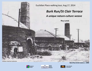
1. Burk Run brick ovens, ~1900
William Hatchel collection
Burk Run brick ovens c. 1900
Euclidian Place walking tour, Aug 17, 2014
Roy Larick
A unique nature-culture weave
Burk Run/St Clair Terrace
Euclid
History
Museum
Bluestone
Heights
City of Euclid
Recreation
2. lake plain
clay pit
wave cut Painesville Moraine
uncut Painesville MoraineHillandale
brickyard Bluestone Business Park
The streams then flow north
on the St. Clair Terrace to
join, farther north on the
lake plain.
At the Euclid-Wickliffe line,
two branches of Burk Run cut
north through the Painesville
Moraine to cross Euclid Ave.
Burk Run is Euclid’s largest yet least
known stream. It has an interesting
history and fairly good potential for
basing a green stream corridor.
Burk Run current geography
3. Arthur St. Clair (1737-1818) by Charles Peale
First governor of the Northwest Territory
Wikipedia
Burk Run on the St. Clair Terrace
East of Cleveland, the St. Clair Terrace rises subtly above
the glacial till-covered lake plain to the north. To the
south, at Euclid Ave, the terrace gives rise to the steep
Portage Escarpment.
Through the 1800s and early 1900s, the terrace was the
focus of East Side agricultural and industrial development.
Since the late 1960s the terrace has lost industry and
population. Now, the St. Clair Terrace may prove helpful
in revitalizing Cleveland’s eastern inner ring communities
around green space and urban forest landscapes.
6. Burk Run brickyard, view north across NKP tracks
Burk Run brickyard, 1898, dba Buckeye Brick
Wickliffe Historical Society
Burk Run brickyard, view east across the clay pit
Van Horn (1916)
In 1881, the Nickel Plate
Railroad set the stage
for area vineyards and a
brickyard. Wickliffe’s
brick downtown grew
quickly, as did Noble in
Euclid.
Burk Run brick ovens, ~1900
William Hatchel
In 1889, the Burk Run
brickyard opened on the
DeKalb Clay at the county
line.
1889 Cleveland Brick
1892 Buckeye Brick & Tile Works
1898 Buckeye Brick
1916 John Kline Brick
1922 McKay Brick
1932 Euclid Shale Brick
Firms at Burk Run
St. Clair Terrace
Burk Run brickyard
clay pit
brickyard
8. Euclid
History
Museum
Euclidian Place walking tour, Aug 14, 2014
Bluestone
Heights
City of Euclid Recreation
St. Clair Terrace
Burk Run wetlands
Now is time to create green
stream corridors in Euclid.
Burk Run’s course across the
St. Clair Terrace is a good
place to start.
Burk Tract
clay pit
brickyard
10. Burk Run brick ovens, ~1900
William Hatchel collection
Burk Run brick ovens c. 1900
Euclidian Place walking tour, Aug 17, 2014
Roy Larick
A unique nature-culture weave
Burk Run/St Clair Terrace
Euclid
History
Museum
Bluestone
Heights
City of Euclid
Recreation