The document discusses the lime industry that existed in the western San Fernando Valley in the 19th and early 20th centuries. Limekilns were located in Woolsey Canyon, Dayton Canyon, and Bell Canyon and produced lime that was used for construction at the Mission San Fernando and in Los Angeles. Recent archaeological findings uncovered two limekilns and an ash field at Dayton Canyon. The industry was operated by Native Americans and involved transporting quarried limestone to the kilns, heating it to produce quicklime, and transporting the product to market.
Chatsworth Hills Homesteaders Part 1
Homesteader Families in the Santa Susana Mountains, north of Chatsworth Street and west of Andora. Includes Dejeremias, Johnson, Graves, Williams, Iverson, Charlton
Chatsworth Hills Homesteaders Part 3, California
Homesteader Families in the Simi Hills, south of Plummer, west of Valley Circle, and north of Roscoe. Includes Schweikhard, Domec, Woolsey and Dayton.
Stoney Point is the most recognized landmark in Chatsworth, California.
Topics include:
Geology – The Chatsworth Formation
Prehistory – Momonga, and The Apeta Momonga Mission Trail
1871 – Earliest map with Stoney Point
1886 – Homesteader George Charlton and family arrives
1920’s residents – Driscoll, Turner, Haworth, Wilson, Johnson
The seven names of Stoney Point
Later residents at the Charlton Residence site
1948-50 – American Legion 4th of July Parade, Carnival and BBQ at Stoney Point
1974 – Los Angeles Historic-Cultural Monument # 132
1982 – Stoney Point is purchased and becomes a 22 acre City Park,
1999 – 52 acres added north of Stoney Point
2007 – The 5 acre Stoney Point Ranch is purchased by the City
Rock Climbing at Stoney Point
Films with Stoney Point
Chatsworth Stagecoach Trail -- The Old Santa Susana Stage Road was designated Los Angeles Historic-Cultural Monument #92 in 1972, and was added to the U.S. National Register of Historic Places in 1974. It is located in the Santa Susana Pass State Historic Park in Chatsworth, California
OSL: A history of its impact on the Wood River Valley, Idaho_part01The Community Library
History of the Oregon Short Line in the Wood River Valley, late 1800s, by John Lundin. Presentation given for the opening of "Railroad Ties," an exhibition at the Sun Valley Museum of History.
Frank Knapp Senior (1875-1952), his wife Maria, and their first three children (Mary, Frank and Alfonso) immigrated from the Tyrol region of Austria to the United States, in 1903.
There would eventually be eight siblings: six boys and two girls. By 1911 the family was established in the new community of Owensmouth, the core area of what would later become Canoga Park, in the west San Fernando Valley.
Frank Senior was a craftsman that worked in wood, stone, concrete, and plaster, and he did a considerable amount of work, much of it artistic, in those medium in the then just-beginning modern development of the west San Fernando Valley.
A presentation given for The Community Library on June 23, 2015, by John Lundin about Guyer Hot Springs resort and Hailey Hot Springs resort. This Power Point presentation uses old photographs and historic materials to discuss two of the hot springs resorts that brought legions of visitors into the Wood River Valley in the late 1800s and early 1900s. Both resorts required significant investment to develop, were actively promoted by the railroad, served both locals and tourists, and were important parts of the valley’s social calendar. The Hailey Hot Springs Resort, located in Croy Canyon, was developed by Robert E. Strahorn, a publicist for Union Pacific Railroad, who was instrumental in bringing the Oregon Short Line Railroad into the Wood River Valley. The resort hotel burned down in 1899, after being visited by dignitaries such as Jay Gould and others who traveled on their private railroad cars. Guyer Hot Springs Resort, located on Warm Springs Creek just west of the ski lift, was the center of Ketchum social activities in the 1890s and early 1900s. The resort ended in 1929, when its owner brought hot springs water to a newly constructed Bald Mountain Hot Springs Lodge on Main Street. The hot springs water was used for heating the Lodge’s units, and to fill its giant swimming pool, where many valley residents swam in the summer. The old Guyer Hot Springs Hotel was torn down in 1937, and used to build the St. Georg Hotel on Main Street, which became Ketchum’s finest. The St. Georg burned down in 1939.
Philadelphia Smelter: A Key Component of the 1880s Silver Rush in the Wood Ri...The Community Library
Presentation on the Philadelphia Smelter, an 1880s silver processing facility, to The Community Library, Regional History Department
by John W. Lundin, June 30, 2015. Pictures courtesy of The Community Library, Lundin Collection, and other sources.
This project is about Writing press releases and editorial. to help you to get some information for your school or university project.
This was a university project that I did with my friend, and I hop you fond it useful
Follow the path of California's first major water project that stretched from Mono Lake to Southern California, delivering the Owens River to support the growth & population of Los Angeles.
The History of the Bells of the El Camino Real. Focused on Chatsworth California history and the Mission Trail from the San Fernando Mission to the Simi House to Mission San Buenaventura.
Includes a clip: The Bells of El Camino Real Huell Howser
The Rockpointe Community in Chatsworth is comprised of 739 units, 4 pools and a clubhouse on 90 acres.
It is west of Valley Circle at Devonshire.
It borders Chatsworth Park South and the Santa Susana Pass State Historic Park to the east, Chatsworth Park North to the north, and Oakwood Cemetery to the south.
It was built in phases, from 1967 to 1971.
Rockpointe South of Devonshire –Ackerman, Shadwick, Longview Poultry, Rim Rock Ranch (Hutchinson, Haberfeld)
Rockpointe North of Devonshire –Dejeremias, Butler, Schepler, Roy Rogers Sports Center
Sullivan County Conservation District Watershed Specialist, Corey Richmond, gave this presentation to schools and involved them in testing on abandoned mines. He covered the history and location of old mines and the company towns.
Homesteaders Families in the Simi Hills
South of Chatsworth Street and North of Plummer
Names and dates of arrival:
Francisco Miranda (1880)
James Hill (1886)
Frank Ackerman (1888)
William Bannon (1891)
Ferdinand Tetzlaff (1893)
Swan Paulson (1895)
Alexander Butler (1896)
Cora Henry (1914)
This presentation will discuss and show three westerns filmed in Chatsworth
A 10 minute Western Spoof filmed in 1968, Blaze Glory
Two TV commercials of Mattel's "Blaze the Galloping Horse" filmed in 1961 and 1962
Episode 5 of the television show Fury, filmed in 1955, which introduces the Fury Barn at Iverson Movie Ranch.
The Santa Susana Pass State Historic Park is a California State Park of 670 acres.
Located in the city of Los Angeles, in Los Angeles County on the boundary between Ventura and Los Angeles counties, between the communities of Chatsworth and Simi Valley
The first six years, 1969 to 1974 - Jan Hinkston and the founding of the SSMPA and FPSSM
The next 23 years, 1975 to 1998 –Land acquisitions culminating in the State Park designation, and volunteer efforts to educate the public about the park.
1986-A short clip from the “Santa Susana Where the Past is Present” promotional video.
1998 –A short video trailer from the 1998 dedication video, and a short clip of Jan Hinkston speaking at the dedication.
The next 25 years, 1998 to 2023 –The drive for improvements, Educational materials created by State Parks, and Volunteer efforts, in coordination with California State Parks, to maintain the park, train volunteers, and lead hikes.
A listing of Educational Resources
Appendix 1 - A History of The SSMPA by Jan Hinkston (up to 1973)
Appendix 2 - Acquisition Summary by Parcel (670 acres)
This presentation will cover the following items.
Our focus tonight is on the 1948 and 1950 Superman movie serials starring Kirk Alyn. Twenty-nine of the 30 movie serial chapters have scenes filmed in Chatsworth.
A brief history of movie serials, aka “Cliffhangers”.
History of Superman from comics to radio to movie serials to TV to big budget movies.
Kirk Alyn photographs from the Jerry England collection
We have posted 58 clips of Superman episodes filmed in Chatsworth (under 5 minutes each) on our YouTube channel. We will share screenshots of some of the scenes, with shooting locations and rock descriptions provided by Dennis Liff.
Viewing of Chapter 1 of 1948 Superman, followed by the beginning of Chapter 2.
In 1921, on Valentine’s Day,
twenty-four women met to form the Chatsworth Women’s Club.
The meeting was held at the home of the founder,
Mrs. Grace Hageman.
This presentation was shared online on February 5 2022
as a part of the Simi Hills Naturalist/Hike Leader Training
• Contributors/Presenters
Dottie Acker
Teena Takata
Ann Vincent
Topics to be covered
•Native American History – The Burro Flats Painted Cave
•Rancho Simi History
•Eddie Maier ownership in 1910
•Henry and Max Silvernale and Bill Hall ownership as partners 1939 to 1954
•Movie History 1937-1954
•Santa Susana Field Lab History 1947 to today
•North American Aviation (NAA) History
•NAA leases land in the Simi Hills 1947, the first test stand was completed in 1949 (Area I)
•NAA purchased Burro Flats/Sky Valley in 1954. The Rocketdyne Division builds four test stand complexes (Area II). The Atomics International Division builds the Sodium Reactor Experiment (Area IV).
•Nuclear research ends 1988; Rocket testing ends in 2006, cleanup continues
Originally the Chatsworth Community Church,
located at 10051 Topanga Canyon Blvd, Chatsworth, California. The Church was built in 1903 with volunteer labor. In 1965, it was moved to Oakwood Memorial Park. Church services continue every Sunday at 10 am
This PowerPoint describes the important contribution made by Native Americans during the conquest of California, during the Mexican-American War of 1846-1848. The “Naval Battalion of Mounted Volunteer Riflemen,” or California Battalion, was one of the most remarkably diverse American military formations in the history of the “Wild West.” Although the California Battalion as a whole never fought a battle, it played a significant role in the conquest of what is now the western United States. And on January 13, 1847, the California Battalion was part of the United States Naval force that accepted the surrender of the last Mexican forces, in what is now the United States, at Campo de Cahuenga, in the San Fernando Valley.
Program presented by Albert Knight (Anthropology Department Associate at the Santa Barbara Museum of Natural History) and Ray Vincent (Historian Chatsworth Historical Society).
This presentation was first shown in November 2011. In addition to the history of the Nike Missile Base LA88 at Oat Mountain, Chatsworth, it featured two videos, “The Nike Hercules Story” (1959, 27 min.), and
“Duck and Cover” (1951, 9 min.). Both of these are available on
YouTube, by searching for the title and “chatsworthhistory1”.
• This presentation includes new history provided to us by Greg Brown, Nike Hercules Crewman LA 88, from 1968-1971.
• Greg also told us about a 1961 “Lassie” TV episode (1961, 21 min.) filmed at LA88 Chatsworth, that will be shown at the end of this presentation.
This presentation was prepared by Dennis Liff, Chatsworth Movie Historian.
This presentation shows examples of spectacular sets that were created at the Garden of the Gods, at Iverson Movie Ranch, during the silent movie era. It analyzes movie stills and publicity photos used from these early times, and discusses how the magnificent and unique silent movie sets were created.
It covers 4 silent movies, and includes silent movie scenes filmed in Chatsworth for the following three movies:
1923 Three Ages – Buster Keaton
1921 Man-Woman-Marriage
1926 Tell it to the Marines
This Presentation will document the filming of the 1917 silent movie Jack and the Beanstalk in today’s Santa Susana Pass State Historic Park (SSPSHP), at the Miranda Homestead in Chatsworth.
It encompasses four chapters:
1. Promotional photographs and identified filming locations of the movie, courtesy of Iverson Ranch and Chatsworth movie historian Dennis Liff.
2. A 1974 interview with Joe Bannon (son of the Chatsworth Park Quarry homesteader William Bannon), who played an integral part in the filming of the 1917 movie. He was interviewed by Jan Hinkston, who in 1970 founded the Santa Susana Mountain Park Association (SSMPA), which led to our current 670 acre SSPSHP in 1998.
3. The recent “rediscovery” of glass lantern slides from the Chatsworth Historical Society, made by Chatsworth Park School students circa 1917, of Jack and the Beanstalk.
4. A recently found 16 minute 4th reel of the previously lost movie, available from the Prelinger archives, that we will watch at the end of the presentation….
This presentation was inspired by the research of Chatsworth Movie Historian Dennis Liff, and his identification in August 2019 of the locations of the outdoor scenes for two groundbreaking movies released in 1914.
His blogpost is mostly reproduced in this presentation.
• The Squaw Man and Judith of Bethulia were both filmed in Chatsworth Lake Manor/Chatsworth Reservoir area
• This presentation will discuss some Hollywood history, identify the filming locations for each film, and show the movie scenes filmed in Chatsworth.
• Both movies are available for viewing on YouTube.
This presentation will cover the following items:
1. A brief history of movie serials, aka “Cliffhangers”
2. The movie history of “Nyoka Cliff” at Iverson Movie Ranch
3. A listing of the main characters, and plot summary, of the 15 chapter 1942 movie serial “Perils of Nyoka”
4. Viewing of two 16 minute chapters, Monster’s Clutch and Tuareg Vengeance, (which just happens to include the classic cliffhanger on Nyoka Cliff)
Topics to be covered
• By 1901 the Bannon family had homesteaded 160 acres, and purchased an additional 40 acres that same year. These 200 acres have four stories to tell:
• De la Ossa Adobe: The 1861 Stagecoach Trail Swing Station, La Cuesta, run by the De la Ossas from Encino (before Bannon)
• Dimension Stone: William Bannon’s contributions to Chatsworth and Southern California via Chatsworth Park Quarry dimension stone and road building projects 1892 to 1901.
• Breakwater Riprap: The Chatsworth Park Quarry supplying millions of tons of riprap sandstone to form the core of the San Pedro Breakwater (after Bannon sells his ranch and quarry in 1901 to the California Construction Company)
• Bannon returns: A final chapter, the Bannon family returns to
Chatsworth in 1906, and live in the Swing Station Adobe from 1912 to 1917.
1903 – The 133-acre Miranda Homestead Property land patent is issued. Their adobe is now a flower
shop in the Oakwood parking lot
• 1923 – Oakwood Cemetery is purchased by Merrick & Ruddick, real estate subdividers. Their Oakwood
Cemetery permit is approved despite protests in 1924.
• 1924 – Oakwood Cemetery Brochure
• 1926 – First Annual Valley-wide Memorial Day Services more than 1,000 people attend
• 1927 – 1
st Mausoleum built by Frank Knapp
• 1928 – St Francis Dam disaster
• 1930 – Fernando Septimo Lopez Moraga
• 1933 – Oakwood Office, Chapel and Crematorium are built
• 1947 – Oakwood Water Well, now in SSPSHP
• 1965 – The 1903 Pioneer church is moved to Oakwood
• 1970-79 – The Cryonics Society stores 9 bodies in an underground vault at Oakwood
• Homestead families buried at Oakwood
• 14 minute movie - “FAMOUS GRAVE TOUR - Oakwood”
Docia A. Conley Corporation was one of Chatsworth’s successful icons from 1915 -1979, located at 21032 Devonshire.
Known to most of us as The Paradise Gift Shop, it also had a Tea Room.
It has been said that The Paradise Tea Room was always a favorite destination to “motor” out to for a Sunday drive.
The family owned business, started by Docia and George Conley, combined a tea room garden setting surrounded by a variety of plants, trees and exotic birds.
1924 – Real Estate subdivider William George Loomis creates the Kadota Fig Farms in Chatsworth
1924 - WG Loomis plants 148 acres of figs at Devonshire and DeSoto
Background on WG Loomis and other Fig Acreage in California
1926 – Docia and George Conley buy a 2 acre fig farm in Chatsworth
Docia Conley has been processing/canning fruit since 1908
In 1915 Conley & Conley is incorporated, and a fruit preserving plant is built in Highland Park on Pasadena Ave.
In 1926 they build The Paradise Tea Room and Gift Shoppe, and a processing plant on their 2 acre fig farm.
20’s and 30’s events, including hosting visitors at the 1932 Summer Olympics
Private Labels for Roy Rogers, Major Dept Stores…
In 1979 the Paradise Gift shop closes and the land is developed.
The Hill-Palmer House, named to the National Register of Historic Places as the only remaining homestead cottage and surrounding gardens in the San Fernando Valley, was built about 1911 by James David and Rhoda Jane Enlow Hill.
In 1974 it was named Los Angeles Historic-Cultural Monument #133, and was added to the National Register of Historic Places in 1979.
Located within the Homestead Acre in Chatsworth Park South, the property is owned by the Los Angeles City Department of Recreation and Parks, with the Chatsworth Historical Society as conservators.
The house, gardens and Chatsworth Museum is open for tours from 1-4 p.m. the first Sunday of every month.
Topics to be covered:
1860’s to 1886 – The Hill family travels from Arkansas to Visalia Ca. to Los Angeles to Chatsworth
Family photographs
1886-1940’s The homesteading years
1950-60’s – the sale of their homestead property to Henry Berkenkamp, Aqua Sierra, and the Roy Roger’s Sports Center
1970’s – Chatsworth Historical Society conservators
Three homestead parcels were combined in the 1950’s and 60’s to create a 127 acre sports center at the west end of Devonshire, on what is today’s Chatsworth Park South and part of Rockpointe.
•There are multiple stories involved:
•The founding of the Aqua Sierra Sportsmans club in 1949, and the building of two skeet and trap stations by 1951/52, before Minnie Hill Palmer sold the Hill homestead.
•The expansion of Aqua Sierra after the 1956 purchase of the Hill homestead by Henry Berkenkamp of Oroweat Bakeries. By 1959, there were five skeet and trap stations, a 90 foot hi-tower, one nine-hole golf course, a driving range, and two trout lakes. In 1959 it is advertised as the Roy Rogers Sports Center.
• In 1961, three additional nine-hole golf courses were added on the adjacent 52 acre Butler/De Jeremias homestead parcels. This acreage was leased from the Scheplers.
•The decline of the sports center began in 1968, when Rockpointe began development on the Butler homestead parcel. In 1973 the City of Los Angeles purchased the 75 acre skeet/fishing/golf course site and it became today’s Chatsworth Park South.
Chatsworth Railroad History
A presentation of historical transportation routes in Chatsworth, focusing on the construction of the Montalvo cutoff completed in 1904
--1769 - El Camino Real
--1861-1895 – Stagecoach Trail
--1876 –San Fernando Tunnel connects Los Angeles to San Francisco and Northern California
--1893 – Southern Pacific Railroad completes Burbank Branch to Chatsworth
--1901 – Southern Pacific opens the Coast Line, linking Los Angeles and San Francisco via major coastal cities
--1904 – Southern Pacific Railroad completes the Montalvo cutoff, making Chatsworth a part of the Southern Pacific Coast Line
--Video clips of Movies filmed at the Chatsworth Tunnels and Depots
The History of the Chatsworth Historical Society, founded in 1963. The group successfully saved and moved the Pioneer Church in 1965. In 1978, they became conservators of the Homestead Acre, which includes the historic Minnie Hill Palmer House and the Chatsworth Museum. The rest is history.......
Palestine last event orientationfvgnh .pptxRaedMohamed3
An EFL lesson about the current events in Palestine. It is intended to be for intermediate students who wish to increase their listening skills through a short lesson in power point.
Honest Reviews of Tim Han LMA Course Program.pptxtimhan337
Personal development courses are widely available today, with each one promising life-changing outcomes. Tim Han’s Life Mastery Achievers (LMA) Course has drawn a lot of interest. In addition to offering my frank assessment of Success Insider’s LMA Course, this piece examines the course’s effects via a variety of Tim Han LMA course reviews and Success Insider comments.
A Strategic Approach: GenAI in EducationPeter Windle
Artificial Intelligence (AI) technologies such as Generative AI, Image Generators and Large Language Models have had a dramatic impact on teaching, learning and assessment over the past 18 months. The most immediate threat AI posed was to Academic Integrity with Higher Education Institutes (HEIs) focusing their efforts on combating the use of GenAI in assessment. Guidelines were developed for staff and students, policies put in place too. Innovative educators have forged paths in the use of Generative AI for teaching, learning and assessments leading to pockets of transformation springing up across HEIs, often with little or no top-down guidance, support or direction.
This Gasta posits a strategic approach to integrating AI into HEIs to prepare staff, students and the curriculum for an evolving world and workplace. We will highlight the advantages of working with these technologies beyond the realm of teaching, learning and assessment by considering prompt engineering skills, industry impact, curriculum changes, and the need for staff upskilling. In contrast, not engaging strategically with Generative AI poses risks, including falling behind peers, missed opportunities and failing to ensure our graduates remain employable. The rapid evolution of AI technologies necessitates a proactive and strategic approach if we are to remain relevant.
Embracing GenAI - A Strategic ImperativePeter Windle
Artificial Intelligence (AI) technologies such as Generative AI, Image Generators and Large Language Models have had a dramatic impact on teaching, learning and assessment over the past 18 months. The most immediate threat AI posed was to Academic Integrity with Higher Education Institutes (HEIs) focusing their efforts on combating the use of GenAI in assessment. Guidelines were developed for staff and students, policies put in place too. Innovative educators have forged paths in the use of Generative AI for teaching, learning and assessments leading to pockets of transformation springing up across HEIs, often with little or no top-down guidance, support or direction.
This Gasta posits a strategic approach to integrating AI into HEIs to prepare staff, students and the curriculum for an evolving world and workplace. We will highlight the advantages of working with these technologies beyond the realm of teaching, learning and assessment by considering prompt engineering skills, industry impact, curriculum changes, and the need for staff upskilling. In contrast, not engaging strategically with Generative AI poses risks, including falling behind peers, missed opportunities and failing to ensure our graduates remain employable. The rapid evolution of AI technologies necessitates a proactive and strategic approach if we are to remain relevant.
2024.06.01 Introducing a competency framework for languag learning materials ...Sandy Millin
http://sandymillin.wordpress.com/iateflwebinar2024
Published classroom materials form the basis of syllabuses, drive teacher professional development, and have a potentially huge influence on learners, teachers and education systems. All teachers also create their own materials, whether a few sentences on a blackboard, a highly-structured fully-realised online course, or anything in between. Despite this, the knowledge and skills needed to create effective language learning materials are rarely part of teacher training, and are mostly learnt by trial and error.
Knowledge and skills frameworks, generally called competency frameworks, for ELT teachers, trainers and managers have existed for a few years now. However, until I created one for my MA dissertation, there wasn’t one drawing together what we need to know and do to be able to effectively produce language learning materials.
This webinar will introduce you to my framework, highlighting the key competencies I identified from my research. It will also show how anybody involved in language teaching (any language, not just English!), teacher training, managing schools or developing language learning materials can benefit from using the framework.
Welcome to TechSoup New Member Orientation and Q&A (May 2024).pdfTechSoup
In this webinar you will learn how your organization can access TechSoup's wide variety of product discount and donation programs. From hardware to software, we'll give you a tour of the tools available to help your nonprofit with productivity, collaboration, financial management, donor tracking, security, and more.
The Roman Empire A Historical Colossus.pdfkaushalkr1407
The Roman Empire, a vast and enduring power, stands as one of history's most remarkable civilizations, leaving an indelible imprint on the world. It emerged from the Roman Republic, transitioning into an imperial powerhouse under the leadership of Augustus Caesar in 27 BCE. This transformation marked the beginning of an era defined by unprecedented territorial expansion, architectural marvels, and profound cultural influence.
The empire's roots lie in the city of Rome, founded, according to legend, by Romulus in 753 BCE. Over centuries, Rome evolved from a small settlement to a formidable republic, characterized by a complex political system with elected officials and checks on power. However, internal strife, class conflicts, and military ambitions paved the way for the end of the Republic. Julius Caesar’s dictatorship and subsequent assassination in 44 BCE created a power vacuum, leading to a civil war. Octavian, later Augustus, emerged victorious, heralding the Roman Empire’s birth.
Under Augustus, the empire experienced the Pax Romana, a 200-year period of relative peace and stability. Augustus reformed the military, established efficient administrative systems, and initiated grand construction projects. The empire's borders expanded, encompassing territories from Britain to Egypt and from Spain to the Euphrates. Roman legions, renowned for their discipline and engineering prowess, secured and maintained these vast territories, building roads, fortifications, and cities that facilitated control and integration.
The Roman Empire’s society was hierarchical, with a rigid class system. At the top were the patricians, wealthy elites who held significant political power. Below them were the plebeians, free citizens with limited political influence, and the vast numbers of slaves who formed the backbone of the economy. The family unit was central, governed by the paterfamilias, the male head who held absolute authority.
Culturally, the Romans were eclectic, absorbing and adapting elements from the civilizations they encountered, particularly the Greeks. Roman art, literature, and philosophy reflected this synthesis, creating a rich cultural tapestry. Latin, the Roman language, became the lingua franca of the Western world, influencing numerous modern languages.
Roman architecture and engineering achievements were monumental. They perfected the arch, vault, and dome, constructing enduring structures like the Colosseum, Pantheon, and aqueducts. These engineering marvels not only showcased Roman ingenuity but also served practical purposes, from public entertainment to water supply.
Instructions for Submissions thorugh G- Classroom.pptxJheel Barad
This presentation provides a briefing on how to upload submissions and documents in Google Classroom. It was prepared as part of an orientation for new Sainik School in-service teacher trainees. As a training officer, my goal is to ensure that you are comfortable and proficient with this essential tool for managing assignments and fostering student engagement.
The West San Fernando Valley Lime Industry and Native American History
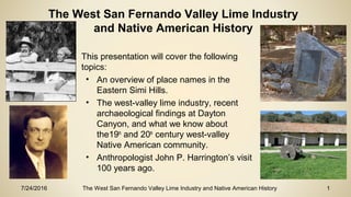
1. 7/24/2016 The West San Fernando Valley Lime Industry and Native American History 1
• This presentation will cover the following
topics:
• An overview of place names in the
Eastern Simi Hills.
• The west-valley lime industry, recent
archaeological findings at Dayton
Canyon, and what we know about
the19th
and 20th
century west-valley
Native American community.
• Anthropologist John P. Harrington’s visit
100 years ago.
The West San Fernando Valley Lime Industry
and Native American History
2. 7/24/2016 The West San Fernando Valley Lime Industry and Native American History 2
Reference Points:
1871 Map of the Ex-
Mission de San
Fernando to Eulogio
de Celis (source
Huntington Digital Library)
1
2
4
3
1 – San Fernando
Mission
2 – Rancho Los
Encinos
3 – Rancho El
Escorpion
4 – Eastern Simi Hills
3. 7/24/2016 The West San Fernando Valley Lime Industry and Native American History 3
1 El Escorpion de las Salinas
- Sitiptip (Chatsworth
Reservoir);
2 Dayton Canyon;
3 Bell Canyon – Huwam;
4 Stoney Point – Momonga; 5
Stagecoach Way Station at
Las Pilitas;
6 Sky Valley / Burro Flats
Village
Eastern Simi Hills 1871 – Overview and Place Names
4
1
Overland Stage
Road
3
5
2
6
4. 7/24/2016 The West San Fernando Valley Lime Industry and Native American History 4
The horizontal blue line is today’s Roscoe
Blvd. The southern half of ex-Mission
lands were sold to Lankershim & Van
Nuys in 1869; the northern half were sold
to McClay & Porter in 1873.
1 Woolsey Canyon; El Escorpion de las
Salinas, La Calera, Pierre Domec and
Maria Odón; Bernabel and Marcelina
Odón adobes
2 Dayton Canyon; house of Jose
Mascarel
3 Bell Canyon; Rancho El Escorpion
granted to Odón; Espiritu his daughter
married Miguel Leonis. Odón Chihuya
and his wife Eusabia were also at Bell
Canyon
Eastern Simi Hills 1871 – West Valley Limekiln Sites
1
3
2
5. 7/24/2016 The West San Fernando Valley Lime Industry and Native American History 5
The Old West Valley Lime Industry –
Summary
• Significant historic limestone processing operations existed at Woolsey, Dayton and Bell
canyons.
• It is generally believed that the earliest operations may have been built to supply mortar,
plaster, and other lime-based products for the Mission San Fernando complex (around
1806).
• There are several historic records concerning the lime kilns and lime works in both Bell
Canyon and Woolsey Canyon, but the kilns at Dayton Canyon, in the center of the prime
area for quality limestone bedrock, have never been described in detail.
• This presentation will describe and discuss all three of these operations, both in terms of
the important lime industry itself, but also because of the importance of the historic west
valley Native American community that operated them.
6. 7/24/2016 The West San Fernando Valley Lime Industry and Native American History 6
Buildings at the San Fernando Mission
• 1797 – First Church Building
• 1798 – Granary and weaving room
• 1799 – second Church Building and granary,
and a dwelling for the padres
• 1801 – six houses for the guards, apartment
for the single girls and women, more
granaries and store rooms
• 1804 – 70 adobe houses for the neophytes
• 1806 – The new church is built
• 1808 – A dam built of masonry, and an
aqueduct from the dam to the Mission
• 1810 – A new house for the fathers and a
new village ranchería consisting of 40
houses. Mission San Fernando Rey de España circa 1870
7. 7/24/2016 The West San Fernando Valley Lime Industry and Native American History 7
• In 1781, at the site of today’s LA Plaza,
the Spanish civilian pueblo “El Pueblo
de Nuestra Señora la Reina de los
Ángeles” was founded.
• As the town grew, pueblos and brick
buildings required a supply of lime for
mortar and plaster.
• The photo to the right shows an 1870’s
view of early Los Angeles as seen from
the Pico House. In the foreground is
the courtyard of the 1781 Spanish
Pueblo. To the left of this, a low white
adobe, is the bakery of Pierre Domec
and his Indian wife, who baked
sourdough French bread. (source LAPL
Photo Collection)
Buildings in early Los Angeles
8. 7/24/2016 The West San Fernando Valley Lime Industry and Native American History 8
The Old West Valley Lime Industry –
Limestone background
• Limestone is a sedimentary rock composed of the minerals calcite and aragonite (i.e.
calcium carbonate), and is largely made of skeletal fragments of marine organisms
including corals, diatoms, and shell materials from larger marine organisms.
• Limestones of various sorts make up about 10% of all of the sedimentary rocks on the
earth, and they are found in almost all parts of the world.
• Geologically, Chatsworth, as a part of the Pacific plate, was once 5,000 feet below sea
level. As the Pacific plate collided with the North American plate at what is today’s San
Andreas fault, the Pacific Plate rose to today’s 1,000 feet above sea level.
• A seam of limestone runs from Bell Canyon to the Woolsey Canyon area. The richest
limestone is in between the two sites in Dayton Canyon.
9. 7/24/2016 The West San Fernando Valley Lime Industry and Native American History 9
Limekilns (Caleras) in the San Fernando Valley
• In 1795, an exploration party searched for a place to establish a new mission, mid-
way between Mission San Gabriel and Mission San Buenaventura. During the
search, it was documented that limestone was already being stockpiled and a kiln
was being built at the site selected for the future 1797 San Fernando mission.
• Other limekilns close to the mission (such as Limekiln canyon north of today’s
Tampa) would have also supplied lime.
• The west valley limekilns (Bell, Dayton and Woolsey Canyon) probably date from
sometime during the mid-19th century, or perhaps even earlier; they may or may not
have supplied processed lime for the Mission San Fernando building complex.
10. 7/24/2016 The West San Fernando Valley Lime Industry and Native American History 10
2014 photo of the limekiln, known as La Calera at El Escorpion de las Salinas,
in Chatsworth Reservoir. Designated in 1975 as L.A. Historic Cultural
Monument 141
Pierre Domec and other
Frenchmen operated
limekilns at El Escorpion de
las Salinas/La Calera in the
1850s-60s. Lime had a ready
market in Los Angeles, for
mortar in brick construction,
for the process of tanning
cowhides, and in sanitation.
The limekiln can be seen today
looking east from the
intersection of Woolsey
Canyon Road and Valley
Circle Blvd.
Chatsworth Limekiln
11. 7/24/2016 The West San Fernando Valley Lime Industry and Native American History 11
Limekilns and how they work
Access arch of the Bell Canyon limekiln
1987 photo courtesy Leonis Adobe
The bricks in the access arch are not adobe bricks, but
fired bricks from the 1850s-60s American Period.
Chatsworth Reservoir limekiln (La Calera)
View of back wall, which is all that remains. This
kiln is built with hand-hewn sandstone blocks and is
over four feet thick; it is at least 18 feet deep
12. 7/24/2016 The West San Fernando Valley Lime Industry and Native American History 12
Limekilns and how they work
Cross section side-view of early pot kiln,
which is a circular structure typically built on
the side of a hill. Wood was layered beneath
layers of limestone and fired for 2 to 3 days,
then cooled for 3 days.
• Lime is generally made by heating
limestone . . . . to over 1,640° F. This drives
carbon dioxide from the rock, leaving
behind processed lime, commonly known
as quicklime or burnt lime.
• Pure lime is white, caustic, lighter in weight
than the original rock, and reacts violently
with water.
• It has many uses, but its principal historic
use was for making mortar and plaster.
When mixed with water and sand, it will
adhere to stone and brick.
• The process of making lime has been
known for thousands of years.
13. 7/24/2016 The West San Fernando Valley Lime Industry and Native American History 13
Limekilns and how they work
• Historically, quicklime was packed
into barrels to protect it from water
or exposure to the air until it was
used.
• There was a cooperage at El Zapo
(the Toad), which is in the foothills
about one mile south of Bell
Canyon.
• Quicklime was an important
resource material used in the
building of the Spanish Missions in
California.
Access arch of the Bell Canyon limekiln
1987 photo courtesy Leonis Adobe, Bob Edberg in photo
14. 7/24/2016 The West San Fernando Valley Lime Industry and Native American History 14
Limekilns and how they work
Natural Limestone on the left; Burnt (processed) quicklime on the right.
Quicklime is ground up to a powder and mixed with water to make plaster or mortar.
Quicklime must be stored in barrels to protect it from moisture.
Examples above are from La Calera at El Escorpion de las Salinas in the Chatsworth Reservoir,
courtesy Chatsworth Historical Society
15. 7/24/2016 The West San Fernando Valley Lime Industry and Native American History 15
West Valley Lime Industry
• This 1865 parcel map identifies a house
at Dayton Canyon as “House of
Mascarel”. Jose Mascarel probably
served as the seller/distributor of lime for
Pierre Domec in Los Angeles. And
Mascarel went to work for Louis Vignes
in 1845 as a cooper.
• In the 1850 census, Pierre Domec is
also identified as a cooper.
• The map also identifies a 160 acre
parcel, just south of Dayton Canyon, to
Charles Leboubon, who was Pierre
Domec’s partner in the lime business.
16. 7/24/2016 The West San Fernando Valley Lime Industry and Native American History 16
Limekiln Findings at Dayton Canyon
• In 2015, grading for the extension of Roscoe
Blvd west of Valley Circle Blvd. exposed two
pot limekilns and an associated ashfield.
• Photo at right - the radiating pattern of reddish
oxidation of the surrounding soil is evidence of
extreme heat.
17. 7/24/2016 The West San Fernando Valley Lime Industry and Native American History 17
Limekiln Findings at Dayton Canyon
• Photo looking north
• Grading for the
extension of Roscoe
Blvd west of Valley
Circle Blvd.
• Exposed two pot
limekilns and a large
associated ashfield to
the west.
18. 7/24/2016 The West San Fernando Valley Lime Industry and Native American History 18
Limekiln Findings at Dayton Canyon
• Photo looking west
• Grading for the extension
of Roscoe Blvd west of
Valley Circle Blvd.
• Exposed two pot limekilns
and a large associated
ashfield to the west.
• Note the long ashfield in
the distance to the west,
identifying other limekilns
in the area.
19. 7/24/2016 The West San Fernando Valley Lime Industry and Native American History 19
Limekiln Findings at Dayton Canyon
Width of kiln is identified in red circular
pattern, 25 feet wide by 20 feet deep
Ashfield to the west of kiln, 100 yards long by
25 yards wide.
20. 7/24/2016 The West San Fernando Valley Lime Industry and Native American History 20
Limekiln Findings at Dayton Canyon
Sideview of exposed Dayton Canyon Limekiln Vitrified Rock at Dayton Canyon Limekiln
21. 7/24/2016 The West San Fernando Valley Lime Industry and Native American History 21
Examples of Vitrified Rock and Oxidation at
Bell Canyon and Woolsey Canyon Limekilns
• Vitrified Rock: Heat over
1,800° F causes rocks
to melt and fuse
together
• Oxidation: Iron Oxides
in sand and stone turn
red as the result of
extreme heat.
Woolsey CanyonBell Canyon
22. 7/24/2016 The West San Fernando Valley Lime Industry and Native American History 22
Limekilns (Caleras) in the San Fernando Valley
• We also need to consider the logistics of
getting the quicklime to where it was
needed: "Because lime is much lighter in
weight than the rock it is made from, it
was easier to haul lime than rock.
Consequently, kilns were usually located
close to the source of the calcium
carbonate" (Perry, et al. 2007:16).
• In the early days of the west valley
operations, simple carretas would have
been used; at least several of these would
have been needed to move any
appreciable amount of product. In time,
wagons, of increasing size, would have
replaced the carretas.
Carreta at Mission La Purisima
23. 7/24/2016 The West San Fernando Valley Lime Industry and Native American History 23
Lime Kiln Plaque at Orcutt Park
Ancient Live Oaks And Old Mission Lime
Kilns 1797-1806
These venerable oak trees were topped by
the Franciscan Friars to furnish fuel for the
nearby lime kilns that provided mortar for the
building of the
Mission San Fernando Rey De Espana
These fused rocks were taken for their
preservation from the remains of the ancient
kilns in this vicinity
Dedicated in honor of
William W. Orcutt
October 2, 1948
Historical Society of Southern California and
California Centennials Commission
24. 7/24/2016 The West San Fernando Valley Lime Industry and Native American History 24
John Peabody Harrington
• John P. Harrington (1884-1961) was an American
linguist and ethnologist and a specialist in the native
peoples of California.
• Harrington’s exhaustive work earned him a position as a
permanent field ethnologist at the Smithsonian, a
position he held for 40 years.
• His field collections include information on placenames
and thousands of photographs, and he gathered more
than 1 million pages of phonetic notations on languages
spoken by tribes from Alaska to South America.
• Harrington devoted much of his life to an intense
examination of the few surviving Chumash people.
• His parents lived in Santa Barbara, and his brother
Robert lived on a small ranch in Simi Valley.
25. 7/24/2016 The West San Fernando Valley Lime Industry and Native American History 25
West Valley Lime Industry
In the 1850’s and 60’s, Frenchmen and Basques were operating
the west valley limekilns.
• Pierre Domec was identified as a limeburner in the 1860
census, and his 1861 and 1865 parcel maps included the
Limekiln 'La Calera'. By 1871 Pierre Domec had moved his
adobe (or had built a new one) slightly north at El Escorpion
de las Salinas, today’s Chatsworth Lake Manor.
• Domec established his relationship in this community by
marrying Maria Dolores, one of the three daughters of Odón
Chihuya, who was one of the three Chumash who were the
grantees of the Mexican Period El Escorpion land-grant,
today’s Bell Canyon. Their first daughter, Francesca, was
born in 1854.
• Maria Dolores and Pierre lived adjacent to La Calera in four
adobes with her brother Bernabel and older sister Marcelina.
Pierre Domec and wife Maria Dolores,
from the Leonis Adobe archives
26. 7/24/2016 The West San Fernando Valley Lime Industry and Native American History 26
The 1865 formal survey of the 1861 sketch by the
Deputy County Surveyor of Los Angeles County,
was for 160 acres.
The 1865 survey boundaries overlaid
on Google Earth in green. The white
outline is La Calera, Domec’s limekiln.
27. 7/24/2016 The West San Fernando Valley Lime Industry and Native American History 27
Miguel Leonis and Espiritu
• Miguel Leonis, a 35-year old French Basque, became a resident
of Rancho El Escorpion (Bell Canyon) in 1859. Leonis raised
sheep, and he was one of many French and French Basques
who came to California in the 1850s to work in that occupation.
The three owners of Rancho El Escorpion allowed Leonis to use
their land for his stock.
• In 1859 he married Espiritu, Odón Chihuya’s third daughter, and
in 1860 their daughter Marcelina was born.
• Leonis built several adobe houses on the north side of Bell
Canyon Creek. His countrymen from France occupied those
houses when they worked the limestone quarries.
• In the 1870’s their home was the Leonis Adobe in Calabasas.
Espiritu Chihuya
Miguel Leonis
28. 7/24/2016 The West San Fernando Valley Lime Industry and Native American History 28
• In 1917 John P. Harrington visited the area and
interviewed Espiritu's son Juan Menéndez (1857-1923),
and his wife Juana, and they visited El Escorpion de las
Salinas.
• Notes from Harrington, related to La Calera, include -
• "Lime pits of the Mission were there" (106-117:9:3)
• "Lime from La Calera was used in Los Angeles
even after the Santa Cruz lime began to be brought
in" (106-117:9:5)
• "Finally the Tehachapi lime was granted such low
rates by the railroads that all competition was
precluded" (106-117:9:6)
Juan and Juana Menéndez, Calabasas, 1917
JP Harrington Collection, Santa Barbara
Museum of Natural History
John P. Harrington’s visit 100 years ago
29. 7/24/2016 The West San Fernando Valley Lime Industry and Native American History 29
John P. Harrington’s visit 100 years ago
• Harrington also interviewed Fernando Sétimo Moraga (aka
Sétimo Moraga López) (1844-1930), and they also visited
El Escorpion de las Salinas.
• Sétimo was a key consultant, providing placenames for
west valley rancherías and many other places.
Sétimo Moraga López in 1916
Harrington Papers, National
Anthropological Archives, Smithsonian
Institution, 91-31239.
30. 7/24/2016 The West San Fernando Valley Lime Industry and Native American History 30
José Juan Olivas in 1916 at the ruins of the old adobe where his “aunts”, the daughters of Odón
Chihuya, lived, at El Escorpion de las Salinas.
Harrington Papers, National Anthropological Archives, Smithsonian Institution, 91-31231.
31. 7/24/2016 The West San Fernando Valley Lime Industry and Native American History 31
“The Final Chapter” on West Valley Quarrying Activities-
Bell Canyon Limestone Quarry
In 1939 to 1941, the limestone hilltop at
the mouth of Bell Canyon was used to
face the Sepulveda Dam Basin.
32. 7/24/2016 The West San Fernando Valley Lime Industry and Native American History 32
Sources/Acknowledgements
Chatsworth Historical Society, 2014, “Chatsworth Lake Manor”, PowerPoint presentation
Cohen, Chester, 1989, “El Escorpion”
Johnson, John, 1997, “Mission San Fernando Indians”
Johnson, John, 1999, Odón Genealogy – “Cultural Affiliation and Lineal Descent of Chumash Peoples”
Johnson, John, 2006, “Ethnohistoric Overview for the Santa Susana Pass State Historic Park Cultural
Resources Inventory Project”
Knight, Albert, 2012, Santa Barbara Museum of Natural History, “Three Chumash-Style Pictograph
Sites in Fernandeño Territory”, SCA Proceedings, Vol 26
Knight, Albert, 2016, “West Valley Lime Industry” (draft)
Prepared by Albert Knight, Santa Barbara Museum of Natural History Department of Anthropology, with
assistance from Bob Edberg, NARC (Northridge Archaelogical Resource Center), Michelle Covello of
the Leonis Adobe, and Ray Vincent of the Chatsworth Historical Society, July 2016