SlideShare a Scribd company logo
Bluestone
Heights
Looking west from the
bluestone cataract waterfall.
Friends of
Euclid Creek
for the
Photo: J. Danforth
Wednesday, August 6, 6:30 pm
264 Richmond Rd, Richmond Heights
© 2014
Bluestone Heights
Walk back in time
Look toward the Future
Greenwood Farm Ravine Preserve
Euclid Creek East Branch
216-524-6580 x 16 / CPosius@cuyahogaswcd.org
Mid Summer’s Night Social
Portage Escarpment nature and history
Photo: J. Danforth
for the
Bluestone
Heights
Friends of
Euclid Creek
Roy Larick and Claire Posius
Join us at Greenwood Farm
© 2014
Bluestone Heights
Presentations by
216-524-6580 x 16 / CPosius@cuyahogaswcd.org
Friends of Euclid Creek
Greenwood Farm Association
Highland Hts Green Task Force
Mid Summer’s Night Social
Looking west from the
bluestone cataract waterfall.
Greenwood Farm Ravine Preserve
Euclid Creek East Branch
Portage Escarpment nature and history
Bluestone
Heights
Friends of
Euclid Creek
for the
Photo: J. Danforth
© 2014
Bluestone Heights
August 6, 2014 brings Mid Summer’s Night Social, a joint meeting
of the Friends of Euclid Creek, the Highland Heights Green Task
Force, and the Greenwood Farm Association.
Greenwood Farm straddles Euclid Creek east branch, just below
the Euclid bluestone waterfall. At the meeting, we will hike the
east branch gorge in the area of the falls.
Greenwood Farm and the nearby Redstone Run Reserve are
models for conserving escarpment run (lake-direct) ravines in
Euclid and Richmond Heights.
Looking west from the
bluestone cataract waterfall.
Greenwood Farm Ravine Preserve
Euclid Creek East Branch
Portage Escarpment nature and history
USGS LiDAR elevations railsandtrails.com Google Earth aerial viewer
Euclid Creek’s east branch drains the Euclid
bluestone terrace of western Lake and
eastern Cuyahoga Counties.
At Greenwood Farm, the east branch cuts
through the hard bluestone to extend a
gorge in the underlying soft shale.
© 2014
Bluestone Heights
Southeast Berea ‘redstone’ massif
Highland
Reserve
Greenwood
Farm
Join us to walk the head of the gorge
With glacial retreat, 16,000 years ago,
rushing melt water generated many
streams along the Portage Escarpment.
Euclid Creek formed between the pre-
glacial Cuyahoga and Chagrin valleys.
Moraine
Euclid
Creek
watershed
© 2014
Bluestone Heights
The east branch gathers
headwaters forced
westward along the
Euclid Moraine.
Portage Escarpment
deglaciation
The main branch begins in high on
the escarpment to flow northward.
ChagrinValley
Cuyahoga
Valley
RichmondRd
Mayfield Rd
Greenwood
Farm
© 2014
Bluestone Heights
The Euclid Moraine & the East Branch
Portage Escarpment at Euclid
Creek east branch
Portage Escarpment nature and history
USGS LiDAR elevations railsandtrails.com Google Earth aerial viewer
Highland
Reserve
Greenwood
Farm
For a short time,
14,000 years ago, the
retreating ice stalled
on the escarpment
north edge and
dropped a ribbon of
fine debris.
This Euclid Moraine
extended from Euclid
Creek westward into
New York State.
The moraine forced
melt water westward,
thereby forming Euclid
Creek east branch.
Several north-flowing
streams, including
Stevenson Brook and
Claribel Creek, became
tributary to the east
branch.
RichmondRd
In early settler days,
Chardon Rd was set on
top of the moraine.
© 2014
Bluestone Heights
Euclid bluestone terrace
Portage Escarpment at Euclid Creek
east branch
As the east branch and
tributaries flow across the
terrace, each cuts a knick
point waterfall and gorge.
During the last 14,000 years,
the bluestone knick points
have migrated upstream
approximately one mile.
The east branch begins atop
the Euclid bluestone, a broad
expanse of hard fine
sandstone. The cap rock
resisted several Ice Age
episodes of glacial buldozing.
Now, the bluestone cap rock
forms the surface of a large
plain stretching from
Cleveland Heights eastward
to the Chagrin River—the
bluestone terrace.
D. Lawrence
Euclid bluestone cap, Redstone Run
Portage Escarpment nature and history
USGS LiDAR elevations railsandtrails.com Google Earth aerial viewer
Bluestone Knick Points
Highland
Reserve
Greenwood
Farm
RichmondRd
© 2014
Bluestone Heights
Greenwood Farm Ravine Preserve
Greenwood Farm
264 Richmond Rd, Richmond Heights, OH 44143
Euclid Creek east branch knick point waterfall
USGS LiDAR elevations railsandtrails.com Google Earth aerial viewer
Portage Escarpment at Euclid Creek east br.
Highland
Reserve
Greenwood
Farm
Greenwood Farm lies
where the east branch
falls over the Euclid
bluestone.
The Greenwood Farm
tour explores the falls
area, known geologically
as a ‘knick point’.
As with all Bluestone
Heights tours, the
Greenwood Farm hike
explores the unique
weave of nature and
culture at a special
place.
Greenwood
Farm
RichmondRd
In 1798, the Connecticut Land Co.
employed John Moss and others to
cut Girdled Rd west from the
Pennsylvania line to Euclid. The west
terminus route is currently found in
OH-84 and Bishop Rd (yellow).
In 1798, Moss bought 720 acres on
Euclid Township’s east line (blue).
Moss may have wanted to take
advantage of the crossroad and the
east branch bluestone knick point
waterfall.
In 1809, Abraham Bishop acquired
the knick point area and established
a grist mill.
In 1814, Jonathan and son Seth D.
Pelton bought the mill and operated
it for a number of years.
Knick Point History OutlineAlso in 1798, Moss bought
84 acres on Euclid’s
shoreline bulge.
The area still bears the
name, Moss Point.
A number of transactions followed until
1908, when George and Maude Phypers
bought 18.62 acres just below the knick
point. They named the parcel
Greenwood Farm (red).
RichmondRd
In 1828, Euclid Township trustees
established 10 school districts. District 6
centered on Peltons Corners.
Euclid Dist 6 ‘Beechnut’
schoolhouse, c. 1890 When the Phypers bought in 1908, the 18.62-
acre parcel held a mid-nineteenth century
farmhouse. The Phypers planned to enlarge
and update the house, but it burned in 1916.
Early settler farmhouse, burned 1916
In 1917, the Phypers decided to build a new
house. They contracted to have it built of
paving brick, probably from the Buckeye Brick
Co. in Eucliid.
At 3,796 sq ft, the house was by far the
largest in newly formed Richmond Heights.
The dwelling featured a finished attic and
large porch.
Phypers house under construction, 1917
Garrison et al. 2005
Phypers collection
Phypers collection
Euclid History Museum
Greenwood Farm basics
In 2004, the City of Richmond Heights purchased
17 remaining acres from the last residing Phypers
descendants.
Presently, the Greenwood Farm Historical,
Cultural & Arts Association, Inc is charged to
preserve the farm and grounds, and to promote
local arts, culture, education and history.
Greenwood Farm Historical, Cultural & Arts Association
http://www.richmondheightsohio.org/GreenwoodFarm.php
© 2014
Bluestone Heights
Escarpment Run Ravine Preserves
D. Lawrence
Euclid bluestone cap, Redstone Run
USGS LiDAR elevations railsandtrails.com Google Earth aerial viewer
Burk Run
Green Creek
Lilly Run
Babbitt Run
Bluestone knick points are
also found on the north side
of the Euclid Moraine, where
small escarpment runs drain
to Lake Erie.
The escarpment runs are
younger than the Euclid
Creek headwaters south of
the moraine. Below the knick
points, the channels cut
through moraine deposits,
not shale.
The ravines are short but
voluminious, with special
ecologies.
Four large escarpment
ravines are available for
conservation within Euclid
and Richmond Heights.
Now is the time to preserve
these ecological treasures.
Greenwood Farm and the nearby Redstone
Run Reserve are models for conserving
escarpment run (lake-direct) ravines in Euclid
and Richmond Heights.
Highland
Reserve
Portage Escarpment at Euclid Creek E br.
RichmondRd
Greenwood
Farm
© 2014
Bluestone Heights
Lilly Run Escarpment Ravine
Portage Escarpment at Euclid Creek east br.
The main Lilly Run
escarpment ravine is related
to Euclid Creek east branch.
The Lilly ravine is a near
mirror to the east branch.
Both ravines have bluestone
knick points opposite each
other on the Euclid Moraine.
The east branch flow
southwest along the
moraine. Lilly Run heads
northwest off the moraine
and continues down the
escarpment to the lake plain.
The Lilly ravine is nearly
hidden from public view. It is
covered by just a few parcels.
The ravine has the remains of
an irrigation pond.
The City of Euclid is
assembling foreclosed
parcels. Paul Kovalcik is
coordinating an ecological
inventory.
USGS LiDAR elevations railsandtrails.com Google Earth aerial viewer
Burk Run
Green Creek
Lilly Run
Babbitt Run
One possible escarpment ravine preserve
covering Euclid and Richmond Heights.
Highland
Reserve
RichmondRd
Bluestone
Heights
Looking west from the
bluestone cataract waterfall.
Friends of
Euclid Creek
for the
Photo: J. Danforth
Wednesday, August 6, 6:30 pm
264 Richmond Rd, Richmond Heights
© 2014
Bluestone Heights
Walk back in time
Look toward the Future
Greenwood Farm Ravine Preserve
Euclid Creek East Branch
216-524-6580 x 16 / CPosius@cuyahogaswcd.org
Mid Summer’s Night Social
Portage Escarpment nature and history

More Related Content

What's hot

Portage Escarpment Deep History
Portage Escarpment Deep HistoryPortage Escarpment Deep History
Portage Escarpment Deep History
Bluestone Heights
 
Doan Brook Parks Nature
Doan Brook Parks NatureDoan Brook Parks Nature
Doan Brook Parks Nature
Bluestone Heights
 
Dugway Brook West Br walking tour
Dugway Brook West Br walking tourDugway Brook West Br walking tour
Dugway Brook West Br walking tour
Bluestone Heights
 
Quilliams Creek walking tour
Quilliams Creek walking tourQuilliams Creek walking tour
Quilliams Creek walking tour
Bluestone Heights
 
Portage Escarpment Ravine Preserves in Euclid, OH
Portage Escarpment Ravine Preserves in Euclid, OHPortage Escarpment Ravine Preserves in Euclid, OH
Portage Escarpment Ravine Preserves in Euclid, OH
Bluestone Heights
 
Exploring Burk Run Terrace
Exploring Burk Run TerraceExploring Burk Run Terrace
Exploring Burk Run Terrace
Bluestone Heights
 
Quilliams Creek walk handout
Quilliams Creek walk handoutQuilliams Creek walk handout
Quilliams Creek walk handout
Bluestone Heights
 
Geomorphology Field Trip
Geomorphology Field TripGeomorphology Field Trip
Geomorphology Field TripJesse Jones
 
Geography 5 project
Geography 5 projectGeography 5 project
Geography 5 project112186
 
Field presentation lake tahoe
Field presentation lake tahoeField presentation lake tahoe
Field presentation lake tahoe
Hean Dyland
 
Cbac Feb 5 2009
Cbac Feb 5 2009Cbac Feb 5 2009
Cbac Feb 5 2009
guest431c62
 
Cop15 12 11 09 Ceswan Bellona Room 7
Cop15 12 11 09 Ceswan Bellona Room 7Cop15 12 11 09 Ceswan Bellona Room 7
Cop15 12 11 09 Ceswan Bellona Room 7
CESwan
 
Hiking rain equipment
Hiking rain equipmentHiking rain equipment
Hiking rain equipmentmoshezuma1
 
Lilly Creek-Arcadia Beach walking tour
Lilly Creek-Arcadia Beach walking tourLilly Creek-Arcadia Beach walking tour
Lilly Creek-Arcadia Beach walking tour
Bluestone Heights
 
Bob & wendy’s trip west part 1
Bob & wendy’s trip west part 1Bob & wendy’s trip west part 1
Bob & wendy’s trip west part 1WendyHedegore
 
Field trip[1]
Field trip[1]Field trip[1]
Field trip[1]ad2315
 

What's hot (19)

Portage Escarpment Deep History
Portage Escarpment Deep HistoryPortage Escarpment Deep History
Portage Escarpment Deep History
 
Doan Brook Parks Nature
Doan Brook Parks NatureDoan Brook Parks Nature
Doan Brook Parks Nature
 
Dugway Brook West Br walking tour
Dugway Brook West Br walking tourDugway Brook West Br walking tour
Dugway Brook West Br walking tour
 
Quilliams Creek walking tour
Quilliams Creek walking tourQuilliams Creek walking tour
Quilliams Creek walking tour
 
Portage Escarpment Ravine Preserves in Euclid, OH
Portage Escarpment Ravine Preserves in Euclid, OHPortage Escarpment Ravine Preserves in Euclid, OH
Portage Escarpment Ravine Preserves in Euclid, OH
 
Exploring Burk Run Terrace
Exploring Burk Run TerraceExploring Burk Run Terrace
Exploring Burk Run Terrace
 
Quilliams Creek walk handout
Quilliams Creek walk handoutQuilliams Creek walk handout
Quilliams Creek walk handout
 
Geomorphology Field Trip
Geomorphology Field TripGeomorphology Field Trip
Geomorphology Field Trip
 
Geography 5 project
Geography 5 projectGeography 5 project
Geography 5 project
 
Field presentation lake tahoe
Field presentation lake tahoeField presentation lake tahoe
Field presentation lake tahoe
 
Cbac Feb 5 2009
Cbac Feb 5 2009Cbac Feb 5 2009
Cbac Feb 5 2009
 
Cop15 12 11 09 Ceswan Bellona Room 7
Cop15 12 11 09 Ceswan Bellona Room 7Cop15 12 11 09 Ceswan Bellona Room 7
Cop15 12 11 09 Ceswan Bellona Room 7
 
Hiking rain equipment
Hiking rain equipmentHiking rain equipment
Hiking rain equipment
 
Lilly Creek-Arcadia Beach walking tour
Lilly Creek-Arcadia Beach walking tourLilly Creek-Arcadia Beach walking tour
Lilly Creek-Arcadia Beach walking tour
 
Death valley (USA)
Death valley (USA)Death valley (USA)
Death valley (USA)
 
Pikes peak
Pikes peakPikes peak
Pikes peak
 
Bob & wendy’s trip west part 1
Bob & wendy’s trip west part 1Bob & wendy’s trip west part 1
Bob & wendy’s trip west part 1
 
Field trip[1]
Field trip[1]Field trip[1]
Field trip[1]
 
Paradigms of Leadership
Paradigms of LeadershipParadigms of Leadership
Paradigms of Leadership
 

Similar to Euclid Creek east branch hike

Ohio & Erie Canal
Ohio & Erie Canal Ohio & Erie Canal
Ohio & Erie Canal
StarkParks
 
Van Tour 98 The Corps 2002
Van Tour 98 The Corps 2002Van Tour 98 The Corps 2002
Van Tour 98 The Corps 2002
How Gregg
 
Favorite Places on a US-33 Roadtrip
Favorite Places on a US-33 RoadtripFavorite Places on a US-33 Roadtrip
Favorite Places on a US-33 Roadtrip
Donald Dale Milne
 
West Creek Headwaters walking tour
West Creek Headwaters walking tourWest Creek Headwaters walking tour
West Creek Headwaters walking tour
Bluestone Heights
 
US-28 (US-126) - A Scenic Road Trip through the Cascade Range
US-28 (US-126) - A Scenic Road Trip through the Cascade RangeUS-28 (US-126) - A Scenic Road Trip through the Cascade Range
US-28 (US-126) - A Scenic Road Trip through the Cascade Range
Donald Dale Milne
 
NostalgicOutdoors™- Acadia National Park - Historic Hiking Trails
NostalgicOutdoors™- Acadia National Park - Historic Hiking TrailsNostalgicOutdoors™- Acadia National Park - Historic Hiking Trails
NostalgicOutdoors™- Acadia National Park - Historic Hiking Trails
NostalgicOutdoors™
 
Dugway Brook W br walk handout
Dugway Brook W br walk handoutDugway Brook W br walk handout
Dugway Brook W br walk handout
Bluestone Heights
 
Boc Feb 5 2009
Boc Feb 5 2009Boc Feb 5 2009
Boc Feb 5 2009
David Richardson
 
5 Postcards from a US-34 Roadtrip
5 Postcards from a US-34 Roadtrip5 Postcards from a US-34 Roadtrip
5 Postcards from a US-34 Roadtrip
Donald Dale Milne
 
Very Cool Michigan High Adventures 05 (Scouts)
Very Cool Michigan High Adventures 05 (Scouts)Very Cool Michigan High Adventures 05 (Scouts)
Very Cool Michigan High Adventures 05 (Scouts)
Steve Lagreca
 
Jordan river parkway
Jordan river parkwayJordan river parkway
Jordan river parkway
Mkejohnson7
 
Fogvg program april 2014
Fogvg program april 2014Fogvg program april 2014
Fogvg program april 2014
Joan Schumaker
 
Euclid Streams into Sewers
Euclid Streams into SewersEuclid Streams into Sewers
Euclid Streams into Sewers
Bluestone Heights
 
A Fisherman's Monument, The Drake
A Fisherman's Monument, The DrakeA Fisherman's Monument, The Drake
A Fisherman's Monument, The DrakeMark Menlove
 
Marcia rasmussen2015masccc
Marcia rasmussen2015mascccMarcia rasmussen2015masccc
Marcia rasmussen2015masccc
GWT
 
Slide Presentation from Public Update Meeting no.1 - A Story of the Park: Peo...
Slide Presentation from Public Update Meeting no.1 - A Story of the Park: Peo...Slide Presentation from Public Update Meeting no.1 - A Story of the Park: Peo...
Slide Presentation from Public Update Meeting no.1 - A Story of the Park: Peo...
MemParkTomorrow
 
Van Tour 90 Florida 2002
Van Tour 90 Florida 2002Van Tour 90 Florida 2002
Van Tour 90 Florida 2002
How Gregg
 

Similar to Euclid Creek east branch hike (20)

Ohio & Erie Canal
Ohio & Erie Canal Ohio & Erie Canal
Ohio & Erie Canal
 
Van Tour 98 The Corps 2002
Van Tour 98 The Corps 2002Van Tour 98 The Corps 2002
Van Tour 98 The Corps 2002
 
Favorite Places on a US-33 Roadtrip
Favorite Places on a US-33 RoadtripFavorite Places on a US-33 Roadtrip
Favorite Places on a US-33 Roadtrip
 
West Creek Headwaters walking tour
West Creek Headwaters walking tourWest Creek Headwaters walking tour
West Creek Headwaters walking tour
 
US-28 (US-126) - A Scenic Road Trip through the Cascade Range
US-28 (US-126) - A Scenic Road Trip through the Cascade RangeUS-28 (US-126) - A Scenic Road Trip through the Cascade Range
US-28 (US-126) - A Scenic Road Trip through the Cascade Range
 
NostalgicOutdoors™- Acadia National Park - Historic Hiking Trails
NostalgicOutdoors™- Acadia National Park - Historic Hiking TrailsNostalgicOutdoors™- Acadia National Park - Historic Hiking Trails
NostalgicOutdoors™- Acadia National Park - Historic Hiking Trails
 
Dugway Brook W br walk handout
Dugway Brook W br walk handoutDugway Brook W br walk handout
Dugway Brook W br walk handout
 
Boc Feb 5 2009
Boc Feb 5 2009Boc Feb 5 2009
Boc Feb 5 2009
 
5 Postcards from a US-34 Roadtrip
5 Postcards from a US-34 Roadtrip5 Postcards from a US-34 Roadtrip
5 Postcards from a US-34 Roadtrip
 
Very Cool Michigan High Adventures 05 (Scouts)
Very Cool Michigan High Adventures 05 (Scouts)Very Cool Michigan High Adventures 05 (Scouts)
Very Cool Michigan High Adventures 05 (Scouts)
 
Jordan river parkway
Jordan river parkwayJordan river parkway
Jordan river parkway
 
Ecomuseum
EcomuseumEcomuseum
Ecomuseum
 
Fogvg program april 2014
Fogvg program april 2014Fogvg program april 2014
Fogvg program april 2014
 
Euclid Streams into Sewers
Euclid Streams into SewersEuclid Streams into Sewers
Euclid Streams into Sewers
 
A Fisherman's Monument, The Drake
A Fisherman's Monument, The DrakeA Fisherman's Monument, The Drake
A Fisherman's Monument, The Drake
 
Marcia rasmussen2015masccc
Marcia rasmussen2015mascccMarcia rasmussen2015masccc
Marcia rasmussen2015masccc
 
Slide Presentation from Public Update Meeting no.1 - A Story of the Park: Peo...
Slide Presentation from Public Update Meeting no.1 - A Story of the Park: Peo...Slide Presentation from Public Update Meeting no.1 - A Story of the Park: Peo...
Slide Presentation from Public Update Meeting no.1 - A Story of the Park: Peo...
 
February25 2010 Wcb Board Meeting Final For Web
February25 2010 Wcb Board Meeting Final For WebFebruary25 2010 Wcb Board Meeting Final For Web
February25 2010 Wcb Board Meeting Final For Web
 
Van Tour 90 Florida 2002
Van Tour 90 Florida 2002Van Tour 90 Florida 2002
Van Tour 90 Florida 2002
 
pondtourbooklet
pondtourbookletpondtourbooklet
pondtourbooklet
 

More from Bluestone Heights

Rockefeller-on-Doan hike handout
Rockefeller-on-Doan hike handoutRockefeller-on-Doan hike handout
Rockefeller-on-Doan hike handout
Bluestone Heights
 
Restoring the Pulse handout
Restoring the Pulse handoutRestoring the Pulse handout
Restoring the Pulse handout
Bluestone Heights
 
Caves & Castles news 2015: genomics
Caves & Castles news 2015: genomicsCaves & Castles news 2015: genomics
Caves & Castles news 2015: genomics
Bluestone Heights
 
Caves & Castles news 2015: archaeology
Caves & Castles news 2015: archaeologyCaves & Castles news 2015: archaeology
Caves & Castles news 2015: archaeology
Bluestone Heights
 
Megaliths & Monuments news, 2016
Megaliths & Monuments news, 2016Megaliths & Monuments news, 2016
Megaliths & Monuments news, 2016
Bluestone Heights
 
Euclid Initial Green Solutions
Euclid Initial Green SolutionsEuclid Initial Green Solutions
Euclid Initial Green Solutions
Bluestone Heights
 
Euclid Green Integrated Planning
Euclid Green Integrated PlanningEuclid Green Integrated Planning
Euclid Green Integrated Planning
Bluestone Heights
 
Euclid Eco-Greenways
Euclid Eco-GreenwaysEuclid Eco-Greenways
Euclid Eco-Greenways
Bluestone Heights
 
CH2M Hill: Onondaga Co green stormwater solutions
CH2M Hill: Onondaga Co green stormwater solutionsCH2M Hill: Onondaga Co green stormwater solutions
CH2M Hill: Onondaga Co green stormwater solutions
Bluestone Heights
 
CH2M Hill: Euclid stormwater Integrated Planing
CH2M Hill: Euclid stormwater Integrated PlaningCH2M Hill: Euclid stormwater Integrated Planing
CH2M Hill: Euclid stormwater Integrated Planing
Bluestone Heights
 
Archaeology at the Alcazar
Archaeology at the AlcazarArchaeology at the Alcazar
Archaeology at the Alcazar
Bluestone Heights
 
Megaliths and Monuments study tour
Megaliths and Monuments study tourMegaliths and Monuments study tour
Megaliths and Monuments study tour
Bluestone Heights
 

More from Bluestone Heights (12)

Rockefeller-on-Doan hike handout
Rockefeller-on-Doan hike handoutRockefeller-on-Doan hike handout
Rockefeller-on-Doan hike handout
 
Restoring the Pulse handout
Restoring the Pulse handoutRestoring the Pulse handout
Restoring the Pulse handout
 
Caves & Castles news 2015: genomics
Caves & Castles news 2015: genomicsCaves & Castles news 2015: genomics
Caves & Castles news 2015: genomics
 
Caves & Castles news 2015: archaeology
Caves & Castles news 2015: archaeologyCaves & Castles news 2015: archaeology
Caves & Castles news 2015: archaeology
 
Megaliths & Monuments news, 2016
Megaliths & Monuments news, 2016Megaliths & Monuments news, 2016
Megaliths & Monuments news, 2016
 
Euclid Initial Green Solutions
Euclid Initial Green SolutionsEuclid Initial Green Solutions
Euclid Initial Green Solutions
 
Euclid Green Integrated Planning
Euclid Green Integrated PlanningEuclid Green Integrated Planning
Euclid Green Integrated Planning
 
Euclid Eco-Greenways
Euclid Eco-GreenwaysEuclid Eco-Greenways
Euclid Eco-Greenways
 
CH2M Hill: Onondaga Co green stormwater solutions
CH2M Hill: Onondaga Co green stormwater solutionsCH2M Hill: Onondaga Co green stormwater solutions
CH2M Hill: Onondaga Co green stormwater solutions
 
CH2M Hill: Euclid stormwater Integrated Planing
CH2M Hill: Euclid stormwater Integrated PlaningCH2M Hill: Euclid stormwater Integrated Planing
CH2M Hill: Euclid stormwater Integrated Planing
 
Archaeology at the Alcazar
Archaeology at the AlcazarArchaeology at the Alcazar
Archaeology at the Alcazar
 
Megaliths and Monuments study tour
Megaliths and Monuments study tourMegaliths and Monuments study tour
Megaliths and Monuments study tour
 

Euclid Creek east branch hike

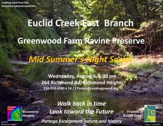
  • 1. Bluestone Heights Looking west from the bluestone cataract waterfall. Friends of Euclid Creek for the Photo: J. Danforth Wednesday, August 6, 6:30 pm 264 Richmond Rd, Richmond Heights © 2014 Bluestone Heights Walk back in time Look toward the Future Greenwood Farm Ravine Preserve Euclid Creek East Branch 216-524-6580 x 16 / CPosius@cuyahogaswcd.org Mid Summer’s Night Social Portage Escarpment nature and history
  • 2. Photo: J. Danforth for the Bluestone Heights Friends of Euclid Creek Roy Larick and Claire Posius Join us at Greenwood Farm © 2014 Bluestone Heights Presentations by 216-524-6580 x 16 / CPosius@cuyahogaswcd.org Friends of Euclid Creek Greenwood Farm Association Highland Hts Green Task Force Mid Summer’s Night Social Looking west from the bluestone cataract waterfall. Greenwood Farm Ravine Preserve Euclid Creek East Branch Portage Escarpment nature and history
  • 3. Bluestone Heights Friends of Euclid Creek for the Photo: J. Danforth © 2014 Bluestone Heights August 6, 2014 brings Mid Summer’s Night Social, a joint meeting of the Friends of Euclid Creek, the Highland Heights Green Task Force, and the Greenwood Farm Association. Greenwood Farm straddles Euclid Creek east branch, just below the Euclid bluestone waterfall. At the meeting, we will hike the east branch gorge in the area of the falls. Greenwood Farm and the nearby Redstone Run Reserve are models for conserving escarpment run (lake-direct) ravines in Euclid and Richmond Heights. Looking west from the bluestone cataract waterfall. Greenwood Farm Ravine Preserve Euclid Creek East Branch Portage Escarpment nature and history
  • 4. USGS LiDAR elevations railsandtrails.com Google Earth aerial viewer Euclid Creek’s east branch drains the Euclid bluestone terrace of western Lake and eastern Cuyahoga Counties. At Greenwood Farm, the east branch cuts through the hard bluestone to extend a gorge in the underlying soft shale. © 2014 Bluestone Heights Southeast Berea ‘redstone’ massif Highland Reserve Greenwood Farm Join us to walk the head of the gorge
  • 5. With glacial retreat, 16,000 years ago, rushing melt water generated many streams along the Portage Escarpment. Euclid Creek formed between the pre- glacial Cuyahoga and Chagrin valleys. Moraine Euclid Creek watershed © 2014 Bluestone Heights The east branch gathers headwaters forced westward along the Euclid Moraine. Portage Escarpment deglaciation The main branch begins in high on the escarpment to flow northward. ChagrinValley Cuyahoga Valley RichmondRd Mayfield Rd Greenwood Farm
  • 6. © 2014 Bluestone Heights The Euclid Moraine & the East Branch Portage Escarpment at Euclid Creek east branch Portage Escarpment nature and history USGS LiDAR elevations railsandtrails.com Google Earth aerial viewer Highland Reserve Greenwood Farm For a short time, 14,000 years ago, the retreating ice stalled on the escarpment north edge and dropped a ribbon of fine debris. This Euclid Moraine extended from Euclid Creek westward into New York State. The moraine forced melt water westward, thereby forming Euclid Creek east branch. Several north-flowing streams, including Stevenson Brook and Claribel Creek, became tributary to the east branch. RichmondRd In early settler days, Chardon Rd was set on top of the moraine.
  • 7. © 2014 Bluestone Heights Euclid bluestone terrace Portage Escarpment at Euclid Creek east branch As the east branch and tributaries flow across the terrace, each cuts a knick point waterfall and gorge. During the last 14,000 years, the bluestone knick points have migrated upstream approximately one mile. The east branch begins atop the Euclid bluestone, a broad expanse of hard fine sandstone. The cap rock resisted several Ice Age episodes of glacial buldozing. Now, the bluestone cap rock forms the surface of a large plain stretching from Cleveland Heights eastward to the Chagrin River—the bluestone terrace. D. Lawrence Euclid bluestone cap, Redstone Run Portage Escarpment nature and history USGS LiDAR elevations railsandtrails.com Google Earth aerial viewer Bluestone Knick Points Highland Reserve Greenwood Farm RichmondRd
  • 8. © 2014 Bluestone Heights Greenwood Farm Ravine Preserve Greenwood Farm 264 Richmond Rd, Richmond Heights, OH 44143 Euclid Creek east branch knick point waterfall USGS LiDAR elevations railsandtrails.com Google Earth aerial viewer Portage Escarpment at Euclid Creek east br. Highland Reserve Greenwood Farm Greenwood Farm lies where the east branch falls over the Euclid bluestone. The Greenwood Farm tour explores the falls area, known geologically as a ‘knick point’. As with all Bluestone Heights tours, the Greenwood Farm hike explores the unique weave of nature and culture at a special place. Greenwood Farm RichmondRd
  • 9. In 1798, the Connecticut Land Co. employed John Moss and others to cut Girdled Rd west from the Pennsylvania line to Euclid. The west terminus route is currently found in OH-84 and Bishop Rd (yellow). In 1798, Moss bought 720 acres on Euclid Township’s east line (blue). Moss may have wanted to take advantage of the crossroad and the east branch bluestone knick point waterfall. In 1809, Abraham Bishop acquired the knick point area and established a grist mill. In 1814, Jonathan and son Seth D. Pelton bought the mill and operated it for a number of years. Knick Point History OutlineAlso in 1798, Moss bought 84 acres on Euclid’s shoreline bulge. The area still bears the name, Moss Point. A number of transactions followed until 1908, when George and Maude Phypers bought 18.62 acres just below the knick point. They named the parcel Greenwood Farm (red). RichmondRd
  • 10. In 1828, Euclid Township trustees established 10 school districts. District 6 centered on Peltons Corners. Euclid Dist 6 ‘Beechnut’ schoolhouse, c. 1890 When the Phypers bought in 1908, the 18.62- acre parcel held a mid-nineteenth century farmhouse. The Phypers planned to enlarge and update the house, but it burned in 1916. Early settler farmhouse, burned 1916 In 1917, the Phypers decided to build a new house. They contracted to have it built of paving brick, probably from the Buckeye Brick Co. in Eucliid. At 3,796 sq ft, the house was by far the largest in newly formed Richmond Heights. The dwelling featured a finished attic and large porch. Phypers house under construction, 1917 Garrison et al. 2005 Phypers collection Phypers collection Euclid History Museum Greenwood Farm basics
  • 11. In 2004, the City of Richmond Heights purchased 17 remaining acres from the last residing Phypers descendants. Presently, the Greenwood Farm Historical, Cultural & Arts Association, Inc is charged to preserve the farm and grounds, and to promote local arts, culture, education and history. Greenwood Farm Historical, Cultural & Arts Association http://www.richmondheightsohio.org/GreenwoodFarm.php
  • 12. © 2014 Bluestone Heights Escarpment Run Ravine Preserves D. Lawrence Euclid bluestone cap, Redstone Run USGS LiDAR elevations railsandtrails.com Google Earth aerial viewer Burk Run Green Creek Lilly Run Babbitt Run Bluestone knick points are also found on the north side of the Euclid Moraine, where small escarpment runs drain to Lake Erie. The escarpment runs are younger than the Euclid Creek headwaters south of the moraine. Below the knick points, the channels cut through moraine deposits, not shale. The ravines are short but voluminious, with special ecologies. Four large escarpment ravines are available for conservation within Euclid and Richmond Heights. Now is the time to preserve these ecological treasures. Greenwood Farm and the nearby Redstone Run Reserve are models for conserving escarpment run (lake-direct) ravines in Euclid and Richmond Heights. Highland Reserve Portage Escarpment at Euclid Creek E br. RichmondRd Greenwood Farm
  • 13. © 2014 Bluestone Heights Lilly Run Escarpment Ravine Portage Escarpment at Euclid Creek east br. The main Lilly Run escarpment ravine is related to Euclid Creek east branch. The Lilly ravine is a near mirror to the east branch. Both ravines have bluestone knick points opposite each other on the Euclid Moraine. The east branch flow southwest along the moraine. Lilly Run heads northwest off the moraine and continues down the escarpment to the lake plain. The Lilly ravine is nearly hidden from public view. It is covered by just a few parcels. The ravine has the remains of an irrigation pond. The City of Euclid is assembling foreclosed parcels. Paul Kovalcik is coordinating an ecological inventory. USGS LiDAR elevations railsandtrails.com Google Earth aerial viewer Burk Run Green Creek Lilly Run Babbitt Run One possible escarpment ravine preserve covering Euclid and Richmond Heights. Highland Reserve RichmondRd
  • 14. Bluestone Heights Looking west from the bluestone cataract waterfall. Friends of Euclid Creek for the Photo: J. Danforth Wednesday, August 6, 6:30 pm 264 Richmond Rd, Richmond Heights © 2014 Bluestone Heights Walk back in time Look toward the Future Greenwood Farm Ravine Preserve Euclid Creek East Branch 216-524-6580 x 16 / CPosius@cuyahogaswcd.org Mid Summer’s Night Social Portage Escarpment nature and history