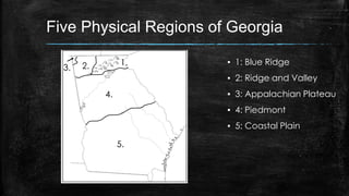
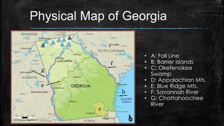
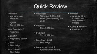
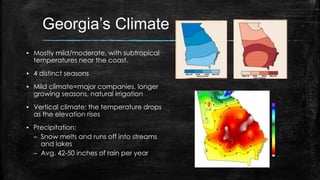
World Map Review
1. ______________________
2. ______________________
3. ______________________
4. ______________________
5. ______________________
6. ______________________
7. ______________________
8. ______________________
9. ______________________
10. ______________________
11. ______________________
The Southeast
g
f
h
e c a
b
d
i
j
a. ______________________
b. ______________________
c. ______________________
d. ______________________
e. ______________________
f. ______________________
g. ______________________
h. ______________________
i. ______________________
j. ______________________
k. ______________________
k
Hemispheres
▪ Hemi- half
▪ Sphere- solid circular figure
▪ In which two
hemispheres
is Georgia
located?
Continents
▪ On which
continent is
Georgia
located?
Nation
▪ To which nation
does Georgia
belong?
Region
▪ In which U.S.
region can
Georgia be
found?
Georgia's Location
Georgia is located in which two hemispheres?
Georgia is located on what continent?
Georgia is located in which nation?
Georgia is located in which region of the United
States?
Georgia’s Geography
Five Physical Regions of Georgia
▪ 1: Blue Ridge
▪ 2: Ridge and Valley
▪ 3: Appalachian Plateau
▪ 4: Piedmont
▪ 5: Coastal Plain
1.2.3.
4.
5.
Physical Map of Georgia
a
b
c
d
e
f
g
• A: Fall Line
• B: Barrier Islands
• C: Okefenokee
Swamp
• D: Appalachian Mts.
• E: Blue Ridge Mts.
• F: Savannah River
• G: Chattahoochee
River
In which region would you find these landforms?
Appalachian Plateau
▪ Location
– Farthest NW corner of GA
▪ Climate
– Mild summers; cooler winters due to higher
elevation; some snow and ice in winter
▪ Resources/Agriculture
– Not good for farming
– Some corn and soybeans grown here
▪ Features & Facts
– Smallest region
– Lookout Mountain & Cloudland Canyon
– Caving is popular
▪ Economics
– Most profitable industries are tourism and
forestry
– Coal, iron ore, and limestone mined here
In which region would you find these landforms?
Coastal Plains
▪ Location?
– Southern half of the state; largest region
– Stretches from east to west state
boundaries
▪ Climate?
– Humid and subtropical
– Long, hot summers and mild winters
▪ Resources/Agriculture
– Fertile soil; most of state’s crops
– Peanuts, Vidalia onions, pecans, soybeans,
cotton
– tourism
▪ Features & Facts
– Barrier islands & Okefenokee swamp
– Inner Plains (farmland) & Outer Plains (coast
& swampland)
▪ Economics
– Pulp & paper industry
– Commercial fishing
– Tourism near barrier islands
– Deepwater ports
In which region would you find these landforms?
Blue Ridge
▪ Location
– Northeast corner
– Southern Appalachian Mts.
▪ Climate
– Most rainfall. Savannah and
Chattahoochee rivers originate here
– Cooler due to higher elevation
▪ Resources/Agriculture
– Small farms in valleys produce apples, corn,
other vegetables
– Pastures home to large animals
▪ Features & Facts
– Brasstown Bald, Georgia’s highest peak
– Beginning of the Appalachian trail
– Dahlonega; 1st gold rush town
▪ Economics
– Harvesting timber
– Historically: mining gold
In which region would you find these landforms?
Piedmont
▪ Location
– North of Coastal Plains
– Stretches from east to west state
boundaries
▪ Climate
– Hot summers, mild winters
– Some snow possibility
▪ Resources/Agriculture
– A lot of agricultural production; cotton, soy,
wheat, poultry/eggs, hogs, cattle/beef,
peaches (along Fall Line)
▪ Features & Facts
– Gently rolling hills; “foot of the hills”
– Red clay
– Urban cities of Atlanta, Columbus, Augusta,
and Macon. Most populous region.
– Stone Mountain
▪ Economics
– A lot of manufacturing and large scale
farming
– National & international businesses
In which region would you find these landforms?
Ridge and Valley
▪ Location
– Northwest GA; east of Appalachian
Plateau
▪ Climate
– Similar to Appalachian Plateau
▪ Resources/Agriculture
– 4% of valley is used as pasture & farmland
– Corn, soybeans, wheat, cotton
– Pine timber
▪ Features & Facts
– Dalton, the carpet capital of the world
– Numerous caves
▪ Economics
– Textile & carpets
– Some mining
Quick Review
• Smallest?
• Appalachian
Plateau
• Largest?
• Coastal Plains
• Most Populated?
• Piedmont
• Carpets?
• Ridge and Valley
• Gold?
• Blue Ridge
• Most rainfall?
• Blue Ridge
• Peaches?
• Piedmont & Coastal
Plains (mostly along Fall
Line)
• Peanuts?
• Coastal Plains
• Swamp?
• Coastal Plains
• Brasstown Bald?
• Blue Ridge
• Lookout Mountain?
• Appalachian Plateau
• Mining?
• Appalachian
Plateau (and a
little Valley &
Ridge)
• Cattle & Poultry?
• Piedmont
Think About It
▪ Savannah was one
of Georgia’s first
permanent
settlements. Why do
you think colonists
chose this location
back in the 1700s?
Savannah River
▪ Forms the eastern border
between Georgia and South
Carolina
▪ Historically
– Explored by De Soto
– Good settlement location for
natives and first Georgians
▪ Today:
– Shipping
– Cooling nuclear power plants
– Hydroelectric power
– Drinking water
Chattahoochee River
▪ Partially forms Georgia’s
western border with
Alabama
▪ Historically used for…
– Transportation for Native
Americans (Too difficult to
use for transportation today
due to shallowness and
rocky waters)
▪ Currently used for…
– industry, drinking water
(especially for ATL), and
recreation
Barrier Islands
▪ A 100 mile line of islands.
▪ Called barrier islands
because they block land
from wind, sand, and water
erosion.
▪ Nationally protected parks
and seashores
▪ Historically used for missions,
forts, and plantations.
Okefenokee Swamp
▪ Largest freshwater
swamp in North
America (700 square
miles)
▪ War between colonists
and natives fought
here
▪ Used to be a source of
timber, until FDR turned
the swamp into a
wildlife refuge area.
The Fall Line
▪ Natural boundary between
the Coastal Plain and
Piedmont regions
▪ Significant drop in elevation,
creating a line of waterfalls
– Because it was the end of
navigable waters for early
settlers, many explorers set up
forts & towns along the Fall Line
▪ Used to be the location of the
Atlantic coast in the
Mesozoic era
▪ Used for mills and
hydroelectric power
Appalachian Mountains
▪ Found in northern regions of
the state
▪ Rounded and weathered,
after millions of years of
erosion
▪ Brasstown Bald – highest peak
in the state – found in Blue
Ridge region
▪ Gold found near Dahlonega in
1828 began the country’s gold
rush
What are the different ways Georgia utilizes
TRANSPORTAITON?
Georgia's Transportation Systems
▪ Economic impact
– Local impact: provide job
opportunities
– Helps the development of cities
– Brings tourists to the state
– Domestic and international trade
(exports and imports)
How did water affect Georgia’s development?
Historical Importance of Water
▪ Chattahoochee, Savannah, and
St. Mary’s rivers create natural
boundaries for Georgia
▪ Natives & early settlers used rivers
for food and transportation
▪ Water used for rice and cotton
farming
▪ Ports of Savannah & Brunswick
used for trade
▪ Rivers transported goods &
people as settlers expanded into
native lands
Georgia’s Climate
▪ Mostly mild/moderate, with subtropical
temperatures near the coast.
▪ 4 distinct seasons
▪ Mild climate=major companies, longer
growing seasons, natural irrigation
▪ Vertical climate: the temperature drops
as the elevation rises
▪ Precipitation:
– Snow melts and runs off into streams
and lakes
– Avg. 42-50 inches of rain per year

Georgia's geography ppt

  • 2.
    World Map Review 1.______________________ 2. ______________________ 3. ______________________ 4. ______________________ 5. ______________________ 6. ______________________ 7. ______________________ 8. ______________________ 9. ______________________ 10. ______________________ 11. ______________________
  • 3.
    The Southeast g f h e ca b d i j a. ______________________ b. ______________________ c. ______________________ d. ______________________ e. ______________________ f. ______________________ g. ______________________ h. ______________________ i. ______________________ j. ______________________ k. ______________________ k
  • 4.
    Hemispheres ▪ Hemi- half ▪Sphere- solid circular figure ▪ In which two hemispheres is Georgia located?
  • 5.
  • 6.
    Nation ▪ To whichnation does Georgia belong?
  • 7.
    Region ▪ In whichU.S. region can Georgia be found?
  • 8.
    Georgia's Location Georgia islocated in which two hemispheres? Georgia is located on what continent? Georgia is located in which nation? Georgia is located in which region of the United States?
  • 9.
  • 10.
    Five Physical Regionsof Georgia ▪ 1: Blue Ridge ▪ 2: Ridge and Valley ▪ 3: Appalachian Plateau ▪ 4: Piedmont ▪ 5: Coastal Plain 1.2.3. 4. 5.
  • 11.
    Physical Map ofGeorgia a b c d e f g • A: Fall Line • B: Barrier Islands • C: Okefenokee Swamp • D: Appalachian Mts. • E: Blue Ridge Mts. • F: Savannah River • G: Chattahoochee River
  • 12.
    In which regionwould you find these landforms?
  • 13.
    Appalachian Plateau ▪ Location –Farthest NW corner of GA ▪ Climate – Mild summers; cooler winters due to higher elevation; some snow and ice in winter ▪ Resources/Agriculture – Not good for farming – Some corn and soybeans grown here ▪ Features & Facts – Smallest region – Lookout Mountain & Cloudland Canyon – Caving is popular ▪ Economics – Most profitable industries are tourism and forestry – Coal, iron ore, and limestone mined here
  • 14.
    In which regionwould you find these landforms?
  • 15.
    Coastal Plains ▪ Location? –Southern half of the state; largest region – Stretches from east to west state boundaries ▪ Climate? – Humid and subtropical – Long, hot summers and mild winters ▪ Resources/Agriculture – Fertile soil; most of state’s crops – Peanuts, Vidalia onions, pecans, soybeans, cotton – tourism ▪ Features & Facts – Barrier islands & Okefenokee swamp – Inner Plains (farmland) & Outer Plains (coast & swampland) ▪ Economics – Pulp & paper industry – Commercial fishing – Tourism near barrier islands – Deepwater ports
  • 16.
    In which regionwould you find these landforms?
  • 17.
    Blue Ridge ▪ Location –Northeast corner – Southern Appalachian Mts. ▪ Climate – Most rainfall. Savannah and Chattahoochee rivers originate here – Cooler due to higher elevation ▪ Resources/Agriculture – Small farms in valleys produce apples, corn, other vegetables – Pastures home to large animals ▪ Features & Facts – Brasstown Bald, Georgia’s highest peak – Beginning of the Appalachian trail – Dahlonega; 1st gold rush town ▪ Economics – Harvesting timber – Historically: mining gold
  • 18.
    In which regionwould you find these landforms?
  • 19.
    Piedmont ▪ Location – Northof Coastal Plains – Stretches from east to west state boundaries ▪ Climate – Hot summers, mild winters – Some snow possibility ▪ Resources/Agriculture – A lot of agricultural production; cotton, soy, wheat, poultry/eggs, hogs, cattle/beef, peaches (along Fall Line) ▪ Features & Facts – Gently rolling hills; “foot of the hills” – Red clay – Urban cities of Atlanta, Columbus, Augusta, and Macon. Most populous region. – Stone Mountain ▪ Economics – A lot of manufacturing and large scale farming – National & international businesses
  • 20.
    In which regionwould you find these landforms?
  • 21.
    Ridge and Valley ▪Location – Northwest GA; east of Appalachian Plateau ▪ Climate – Similar to Appalachian Plateau ▪ Resources/Agriculture – 4% of valley is used as pasture & farmland – Corn, soybeans, wheat, cotton – Pine timber ▪ Features & Facts – Dalton, the carpet capital of the world – Numerous caves ▪ Economics – Textile & carpets – Some mining
  • 22.
    Quick Review • Smallest? •Appalachian Plateau • Largest? • Coastal Plains • Most Populated? • Piedmont • Carpets? • Ridge and Valley • Gold? • Blue Ridge • Most rainfall? • Blue Ridge • Peaches? • Piedmont & Coastal Plains (mostly along Fall Line) • Peanuts? • Coastal Plains • Swamp? • Coastal Plains • Brasstown Bald? • Blue Ridge • Lookout Mountain? • Appalachian Plateau • Mining? • Appalachian Plateau (and a little Valley & Ridge) • Cattle & Poultry? • Piedmont
  • 23.
    Think About It ▪Savannah was one of Georgia’s first permanent settlements. Why do you think colonists chose this location back in the 1700s?
  • 24.
    Savannah River ▪ Formsthe eastern border between Georgia and South Carolina ▪ Historically – Explored by De Soto – Good settlement location for natives and first Georgians ▪ Today: – Shipping – Cooling nuclear power plants – Hydroelectric power – Drinking water
  • 25.
    Chattahoochee River ▪ Partiallyforms Georgia’s western border with Alabama ▪ Historically used for… – Transportation for Native Americans (Too difficult to use for transportation today due to shallowness and rocky waters) ▪ Currently used for… – industry, drinking water (especially for ATL), and recreation
  • 26.
    Barrier Islands ▪ A100 mile line of islands. ▪ Called barrier islands because they block land from wind, sand, and water erosion. ▪ Nationally protected parks and seashores ▪ Historically used for missions, forts, and plantations.
  • 27.
    Okefenokee Swamp ▪ Largestfreshwater swamp in North America (700 square miles) ▪ War between colonists and natives fought here ▪ Used to be a source of timber, until FDR turned the swamp into a wildlife refuge area.
  • 28.
    The Fall Line ▪Natural boundary between the Coastal Plain and Piedmont regions ▪ Significant drop in elevation, creating a line of waterfalls – Because it was the end of navigable waters for early settlers, many explorers set up forts & towns along the Fall Line ▪ Used to be the location of the Atlantic coast in the Mesozoic era ▪ Used for mills and hydroelectric power
  • 29.
    Appalachian Mountains ▪ Foundin northern regions of the state ▪ Rounded and weathered, after millions of years of erosion ▪ Brasstown Bald – highest peak in the state – found in Blue Ridge region ▪ Gold found near Dahlonega in 1828 began the country’s gold rush
  • 30.
    What are thedifferent ways Georgia utilizes TRANSPORTAITON?
  • 31.
    Georgia's Transportation Systems ▪Economic impact – Local impact: provide job opportunities – Helps the development of cities – Brings tourists to the state – Domestic and international trade (exports and imports)
  • 32.
    How did wateraffect Georgia’s development?
  • 33.
    Historical Importance ofWater ▪ Chattahoochee, Savannah, and St. Mary’s rivers create natural boundaries for Georgia ▪ Natives & early settlers used rivers for food and transportation ▪ Water used for rice and cotton farming ▪ Ports of Savannah & Brunswick used for trade ▪ Rivers transported goods & people as settlers expanded into native lands
  • 34.
    Georgia’s Climate ▪ Mostlymild/moderate, with subtropical temperatures near the coast. ▪ 4 distinct seasons ▪ Mild climate=major companies, longer growing seasons, natural irrigation ▪ Vertical climate: the temperature drops as the elevation rises ▪ Precipitation: – Snow melts and runs off into streams and lakes – Avg. 42-50 inches of rain per year