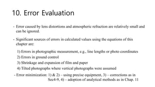
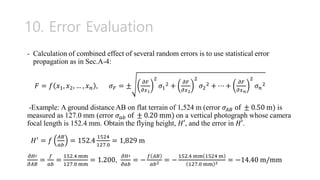
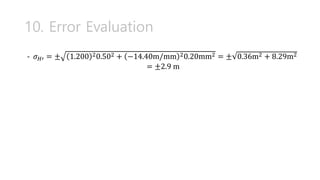
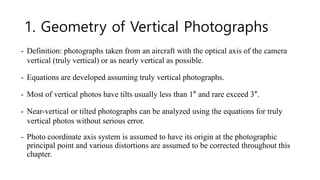
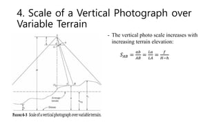
Chapter 6 discusses vertical photographs in photogrammetry and GIS applications, focusing on their geometry, scale determination, and the impact of terrain on photo scales. It presents methods for deriving ground coordinates, understanding relief displacement, and calculating flying heights while addressing potential sources of error in photogrammetric measurements. Various examples illustrate the concepts and equations necessary for accurate analysis in aerial photography.

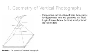
![3. Scale of a Vertical Photograph over
Flat Terrain
- The scale of a vertical photograph over
flat terrain is the ratio of photo distance
ab to ground distance AB, or of focal
length f to height H’:
𝑆 =
𝑎𝑏
𝐴𝐵
=
𝑓
𝐻′
[Example 6-1] A vertical aerial photo is
taken over flat terrain with 152.4 mm of
focal length and 1,830 m of height. Photo
scale?
𝑆 =
𝑓
𝐻′
=
0.1524
1830
= 1/12,000 = 1:12,000](https://image.slidesharecdn.com/05photogrammetry-ch6-verticalphotographs-240623132533-5c16c987/85/05_Photogrammetry-ch6-Vertical-Photographs-pdf-5-320.jpg)
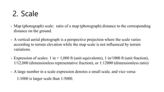
![5. Average Photo Scale
- Average scale is the scale at the average elevation of the terrain:
[Example 6-2] The highest terrain ℎ1, average terrain ℎ𝑎𝑣𝑔, and lowest terrain ℎ2
are 610, 460, 310 m above mean sea level, respectively. Calculate the maximum,
minimum, and average scales if flying height above mean sea level is 3000 m and
the camera focal length is 152.4 mm.
𝑆𝑚𝑎𝑥 =
0.1524
3000−610
= Τ
1
15,700 = 1: 15,700, 𝑆𝑚𝑖𝑛 =
0.1524
3000−310
= Τ
1
17,700 =
1: 17,700
𝑆𝑎𝑣𝑔 =
0.1524
3000−460
= Τ
1
16,700 = 1: 16,700
𝑆𝑎𝑣𝑔 =
𝑓
𝐻 − ℎ𝑎𝑣𝑔](https://image.slidesharecdn.com/05photogrammetry-ch6-verticalphotographs-240623132533-5c16c987/85/05_Photogrammetry-ch6-Vertical-Photographs-pdf-7-320.jpg)
![6. Other Methods of Determining Scale
of Vertical Photographs
- The scale can be simply determined by the ratio of the photo distance to the
ground distance.
[Example 6-3] The horizontal distance AB between the centers of two street
intersections was measured on the ground as 402 m. Corresponding line ab on a
vertical photograph was 95.8 mm. Photo scale of the line?
- The scale of a vertical aerial photograph can be determined if a map of the
corresponding area is available
𝑆 =
0.0958
402
=
1
4200
= 1: 4200
𝑆 =
photo distance
map distance
map scale](https://image.slidesharecdn.com/05photogrammetry-ch6-verticalphotographs-240623132533-5c16c987/85/05_Photogrammetry-ch6-Vertical-Photographs-pdf-8-320.jpg)
![6. Other Methods of Determining Scale
of Vertical Photographs
[Example 6-4] An airport runway measures 160 mm on a vertical photograph and
103 mm on a map whose scale is 1:24,000. Scale of the photograph?
𝑆 =
160
103
1
24,000
=1/15,400=1:15,400](https://image.slidesharecdn.com/05photogrammetry-ch6-verticalphotographs-240623132533-5c16c987/85/05_Photogrammetry-ch6-Vertical-Photographs-pdf-9-320.jpg)
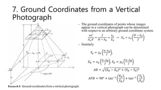
![7. Ground Coordinates from a Vertical
Photograph
[Example 6-6]](https://image.slidesharecdn.com/05photogrammetry-ch6-verticalphotographs-240623132533-5c16c987/85/05_Photogrammetry-ch6-Vertical-Photographs-pdf-11-320.jpg)
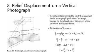
![8. Relief Displacement on a Vertical
Photograph
- Relief displacement occurs radially from the
center of the photograph (principal point).
[Example 6-7] A vertical photo taken from an
elevation of 535 m above mean sea level. The
elevation at the base of a tower in the photo is
259 m above MSL. The relief distance d of
the tower is 54.1 mm, and the radial distance
to the top of the tower from the photo center
was 121.7 mm. What is the height of the tower?
→𝐻 = 535 − 259 = 276 m
h =
𝑑𝐻
𝑟
=
54.1 276
121.7
= 123 m](https://image.slidesharecdn.com/05photogrammetry-ch6-verticalphotographs-240623132533-5c16c987/85/05_Photogrammetry-ch6-Vertical-Photographs-pdf-13-320.jpg)
![9. Flying height of a Vertical Photograph
- Flying height above datum is an important quantity for solving photogrammetric
equations such as in scale, ground coordinate, and relief displacement.
[Example 6-8] A section line whose length is 5,280 ft on fairly level terrain is
measured 94.0 mm on photograph. Find the flying height if the camera focal length
is 88.9 mm.
𝑆 =
𝑓
𝐻
→ 𝐻 =
𝑓
𝑆
=
88.9
94.0/5,280
= 4,993.5ft = 1,522 m](https://image.slidesharecdn.com/05photogrammetry-ch6-verticalphotographs-240623132533-5c16c987/85/05_Photogrammetry-ch6-Vertical-Photographs-pdf-14-320.jpg)
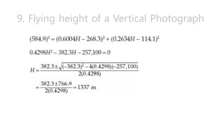
![9. Flying height of a Vertical Photograph
[Example 6-9] Ground point A and B have elevation 437.4 m and 445.3 m above sea
level, respectively, and the horizontal length of line AB is 584.9 m. The measured
photo coordinates of a and b which are images of A and B are 𝑥𝑎 = 18.21 mm, 𝑦𝑎 =
− 61.32 mm, 𝑥𝑏 = 109.65 mm, and 𝑦𝑏 = −21.21 mm. Calculate the flying height
of the photograph above sea level.](https://image.slidesharecdn.com/05photogrammetry-ch6-verticalphotographs-240623132533-5c16c987/85/05_Photogrammetry-ch6-Vertical-Photographs-pdf-15-320.jpg)