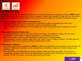
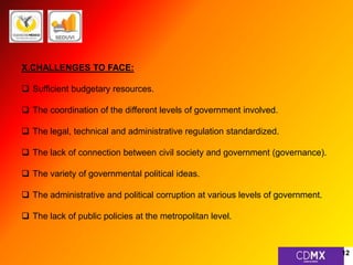
1 
GOVERNMENT OF THE FEDERAL DISTRICT
GOVERNMENT OF THE FEDERAL DISTRICT 
MEXICO CITY 
MINISTERY OF URBAN DEVELOPMENT AND HOUSING 
DIRECTION OF LAND USES (URBAN ADMINISTRATION) 
LUIS ANTONIO GARCÍA CALDERÓN 
2
MEXICO CITY, FEDERAL DISTRICT 
I.- HISTORY: 
Mexico City (hereinafter CDMX), capital of the Aztec Empire, was founded in 1325 by the Mexicas, with the name 
of Tenochtitlan. In 1521 the Spanish Empire, commanded by Hernán Cortés takes Mexico City, an event that 
marks the conquest of Mexico. In 1535 the viceroyalty of the New Spain was created and Mexico City, 
established over Tenochtitlan, was declared as the capital of the viceroyalty. 
On November 18th of 1824, in independent Mexico, Congress created a Federal District, as distinct from the other 
states of the Federation, to house the executive, legislative and judicial branches, a territory that did not belong to 
any state federal entity, thus avoiding the influence of one state over the other. Mexico City was designated the 
seat of the powers of the Union and capital of the United Mexican States. 
II.- POLITICAL STRUCTURE: 
Mexico City, kwon as Federal District (Mexico, D.F.), is currently the capital and seat of the federal powers of 
Mexico. It is a federal entity that, together with the remaining 31 states make up the Mexican federation, a 
federalized area being considered for hosting the federal powers and capital of the United Mexican States. 
Mexico City is part of the Metropolitan Area of the Valley of Mexico (hereinafter ZMVM), formed by 3 federative 
entities: Federal District (16 delegations/State of Mexico (59 municipalities) y the State of Hidalgo (1 municipality). 
3
4
III.- CHARACTERISTICS: 
Mexico City is a very significant metropolis, bringing together several features that make it unique: 
• It is a city 
• It is a federal state 
• It is part of the ZMVM 
• It is the capital of the United Mexican States (Mexico) 
• It is the largest conglomerate in the Americas (along with New York) 
• It is most populous Spanish-speaking city on earth 
• It is the 3rd largest urban agglomeration in the world 
IV.- GEOGRAPHY: 
Mexico City is located in the south of the Basin of Mexico in the Midwest, with an average altitude of 2,240 meters 
above sea level. Mexico City has an area of 1,495 km2, which represents 0.1% of the country. 
Mexico City is formed by 3 states and 76 municipalities: the Federal District (16 delegations), the State of Mexico 
(59 municipalities) and the State of Hidalgo (one municipality), with an area of 7,854 km2, of this 65.5% is of use 
urban and 34.5% rural. 
Federal District (16 delegations) 
State of Mexico (59 municipalities) 
State of Hidalgo (one municipality) 
5
6
V.- DEMOGRAPHY: 
Mexico City’s (CDMX) population is around 8.8 million, but as part of the ZMVM sum has a 
population of over 20 million inhabitants, being the world's 3rd largest urban agglomeration, only 
after Tokyo, Japan with 37.2 million and New Delhi, India with 22.7 million inhabitants, tied with 
New York, USA that has the same number of inhabitants. 
The ZMVM has: 20,116,842 2010 census (17.9% of the total population of Mexico) 
Federal District (8,851,080) (7.88% of total population) 
State of Mexico (11,168,301) (9.94% of total population) 
State of Hidalgo (97.461) (0.1% of total population) 
Mexico has had an accelerated transition, a constant population growth and urban sprawl, and has 
been changing the trend of population growth after changing from a predominantly rural country to 
an urban in the period of 1940-1980. In these 40 years, 55 cities accounted for 20% of the national 
population, they became 277 population centers with a concentration of 55%. By 2010 77% of the 
population lived in 384 cities by 2030 it is expected that the towns harbor 81% of the national 
population (CONAPO 2007). 
7
VI.- DENSITY: 
The population density of the ZMVM is 2559.8 inhabitants per km2. In 1960 Mexico had 12 metropolitan areas, by 
2010 there were 59 metropolitan areas in which they live 6 out of 10 Mexicans being the ZMVM conglomeration 
representing 17.9% of the total population, excluding the floating population. 
VII.- ECONOMY: 
Mexico City is the country's largest urban center, and the main political, academic, economic, financial, business 
and cultural center. Mexico City obtained a GDP in 2011 of 470 billion. While in 2012 had an average growth of 
3.5%, which increased its GDP to 486.5 billion. Billed as a global city, Mexico City is one of the most important 
business and cultural centers of America and the world. The growth of the city is one of the fastest in the world, 
and its economy is expected to triple by 2020. 
In between the main economic indicators are: 
The 29% of GDP is contributed by the ZMVM 
73% of the GDP of the ZMVM is provided by Mexico City 
Mexico City occupies 7th place in the Latin American ranking for business 
The 353 largest companies in the country are located in Mexico City (500) 
60% of Foreign Direct Investment (FDI) remains in Mexico City 
VIII.- URBAN STATUS: 
The territory of Mexico City presents a pattern of inefficient and inequitable disjointed occupation that has caused 
excessive consumption of resources, unequal distribution of equipment, infrastructure and urban services and 
underutilization, impairment and deterioration. 8
IX.- DIFFICULTIES: 
To understand the expansive phenomenon of Mexico City, we should analyze the metropolitan context as ZMVM together 
with the municipalities around Mexico City. The current pattern of growth and occupation of urban and non-urban areas of 
Mexico City has generated negative effects on their development; these effects are included in the following manner: 
A. Growth in extensive urban sprawl and dispersed form 
• The limits of Mexico City have been overran by the urban sprawl, creating marginalized peri-urban areas. 
• Mexico City’s growth was based on a horizontal, expansive and dispersed model. 
• Growth has been costly, impacting the environmental value of land, conservation areas and protection of natural 
areas. 
B. Metropolitan Functional Relationship 
• The relationship between Mexico City, State of Mexico and Hidalgo, has affected the quality of life and human 
development, as three quarters of regional employment is concentrated in this area. 
• Mexico City’s quality of life and human development is well above the other two entities. 
• The relationship is crossed in different fields, as for work, study or home, an effect of migration, overnight areas and 
underserved areas occurs, causing a growing and intense daily mobility. 
C. Demographic Explosion: 
• The largest concentrations of population of ZMVM is located in the delegations from the east and north of Mexico City 
(Gustavo A. Madero and Iztapalapa) and the mexiquenses municipalities in eastern and northern (Ecatepec and 
Nezahualcoyotl). 
• The legal, political and administrative coordination between entities that share responsibility for planning and 
managing the metropolis, have not led to the development and growth of urban infrastructure to serve the entire 
population through the provision of adequate public services and quality. 
9
D. Monocentric urban structure 
• The structure of land use in Mexico City is mainly dominated by mono-functional areas for 
housing and commercial / industrial uses or services. These zones must be multipurpose and 
multifunctional zones. 
• Urban sprawl tends to expand to rural areas and ecological preservation. 
• The central area of Mexico City is more attractive for diversity and mixed use. 
• The rest of the country does not allow multifunctionality to meet basic needs. 
E. Imbalance in provision of infrastructure, services and equipment 
• The concentrated growth territorial distribution, infrastructure and services has inhibited 
investment, employment, limiting access to economic, social, cultural and environmental rights. 
• The quality of life of the population has been diminished especially in the sectors under 
conditions of exclusion, marginalization and vulnerability that lie on the outskirts of the City. 
• The underutilization of equipment, inadequate infrastructure and basic services provided, and 
has led to the saturation deficiency in service delivery, especially in housing. 
10
# GREEN SPACES 3,306M2 
SOCIAL 
DIVERSITY 
TOTAL 8,851,080 
CHILDREN 22.40% 
TEENANGERS 25.46% 
(0 to 14 YEARS OLD)) 
ADULTS 44.19% 
(29 to 65 YEARS OLD) 
SENIORS 7.95% 
M2 OF 
GREENERY/ 
PER CAPITA 
HOUSING 3.61 
# POPULATION/ 
200,000 
28.7% LIVES IN AN 
APARTMENT 
681,818 KM. 
THE SUBWAY MOVES 
1,400 MILLIONS OF 
PASSENGERS 
ANNUALY 
ANNUAL HOUSING DEMAND 
8.4 
% 
UNEMPLOYMENT 
5.3% 
6.17% 
6.48% 
% TERTIARY 
ECONOMIC ACTIVITIES 
44.51% 
SELF 
O NO AFFILIATION 
% URBAN 
INDUSTRIAL SOIL 
IN THE FEDERAL 
DISTRICT 
2.83% 
11
X.CHALLENGES TO FACE: 
 Sufficient budgetary resources. 
 The coordination of the different levels of government involved. 
 The legal, technical and administrative regulation standardized. 
 The lack of connection between civil society and government (governance). 
 The variety of governmental political ideas. 
 The administrative and political corruption at various levels of government. 
 The lack of public policies at the metropolitan level. 
12
- Requires to build 48,000 homes a year and abate the 
historical lag of 200,000 
-Should reverse the deficit of public space 5m2 / 
inhabitant 
- Should increase the feasibility of 
water 
- Must expand the network of public transportation (only 38% of 
the population lives in the radius of the pedestrian) 
- Must relocate more than 800 irregular settlements in 
conservation land 
- Have to collect 12,500 tons of solid waste per day. 
13
IX.- GUIDING AXLES FOR A SUSTAINABLE URBAN DEVELOPMENT 
A social capital, where people enjoy their full rights and equal opportunities; where people in vulnerable situations 
is supported with dignity and is fair and inclusive; a city of freedoms and tolerance, where diversity becomes a 
social and human value, in which gender equality is fully respected; a safe city; a dynamic, compact, polycentric, 
competitive and sustainable city, to boost productive vocations and encourage investment; and a city of 
knowledge, digital and intelligent responsible, professional government, effective, transparent, participatory, and 
honest. 
A. Compact City 
C. Dynamic City 
B. Policentric City 
D. Equitable City 
14
A. Compact City: The core that keeps the ratio between the building density, the distribution of 
applications and the rate of green space in order to reduce consumption of land. 
B. Polycentric City: The city with a decentralized urban structure defined by paths, edges, nodes, 
landmarks and sectors distributed along the urban fabric, defining sectors that act as organizers 
nodes adjacent areas, through the ministry of housing, services and employment, constitutes a 
precondition for the harmonious and sustainable development, with different land uses for areas to 
avoid long commutes population, which affects the environment condition. 
C. Dynamic City: The city that undergoes constant change and transformation, adapting to the 
needs of population, housing, services, employment and transportation, but with sustainable growth 
that raises the quality of life of the population. 
D. Equitable: It's a city of freedoms, tolerance, with social and human value, where everyone has 
access to housing, services, employment and transportation. 
15
X.- PROPOSALS 
The institutional response requires proper planning and land management, as well as a consistent and standardized regulatory 
framework offering proper coordination within the interagency and intergovernmental framework, as well as between government, 
private and social actors, for which this is proposed: 
 Plan urban development under a sustainable, compact, polycentric, dynamic and fair context. 
 Update general programs, borough programs, subprograms and general management standards. 
 Propose public policies on housing, with criteria redensification, relocation, retraining and polycentricity. 
 Check the peri-urban land and natural boundaries of the conurbated areas. 
 Encourage rental properties in urban areas. 
 Controlling the induced growth of urban sprawl and traffic on the environmental impact. 
 Integrate (ejido land) “commons” to the metropolitan area that have become part of the metropolitan area. 
 Strengthen regulatory government agencies in urban matters. 
 Include in the National Development Plan, a specific and related to urban planning guiding principle. 
 Guide the implementation of the budget in urban renewal programs. 
 Financing sustainable development programs, housing, public transport and provision of public services. 
 Establish regulatory environmental measures for sustainable development. 16

[Urban Management Program City Paper : Mexico City, Mexico]

  • 1.
    1 GOVERNMENT OFTHE FEDERAL DISTRICT
  • 2.
    GOVERNMENT OF THEFEDERAL DISTRICT MEXICO CITY MINISTERY OF URBAN DEVELOPMENT AND HOUSING DIRECTION OF LAND USES (URBAN ADMINISTRATION) LUIS ANTONIO GARCÍA CALDERÓN 2
  • 3.
    MEXICO CITY, FEDERALDISTRICT I.- HISTORY: Mexico City (hereinafter CDMX), capital of the Aztec Empire, was founded in 1325 by the Mexicas, with the name of Tenochtitlan. In 1521 the Spanish Empire, commanded by Hernán Cortés takes Mexico City, an event that marks the conquest of Mexico. In 1535 the viceroyalty of the New Spain was created and Mexico City, established over Tenochtitlan, was declared as the capital of the viceroyalty. On November 18th of 1824, in independent Mexico, Congress created a Federal District, as distinct from the other states of the Federation, to house the executive, legislative and judicial branches, a territory that did not belong to any state federal entity, thus avoiding the influence of one state over the other. Mexico City was designated the seat of the powers of the Union and capital of the United Mexican States. II.- POLITICAL STRUCTURE: Mexico City, kwon as Federal District (Mexico, D.F.), is currently the capital and seat of the federal powers of Mexico. It is a federal entity that, together with the remaining 31 states make up the Mexican federation, a federalized area being considered for hosting the federal powers and capital of the United Mexican States. Mexico City is part of the Metropolitan Area of the Valley of Mexico (hereinafter ZMVM), formed by 3 federative entities: Federal District (16 delegations/State of Mexico (59 municipalities) y the State of Hidalgo (1 municipality). 3
  • 4.
  • 5.
    III.- CHARACTERISTICS: MexicoCity is a very significant metropolis, bringing together several features that make it unique: • It is a city • It is a federal state • It is part of the ZMVM • It is the capital of the United Mexican States (Mexico) • It is the largest conglomerate in the Americas (along with New York) • It is most populous Spanish-speaking city on earth • It is the 3rd largest urban agglomeration in the world IV.- GEOGRAPHY: Mexico City is located in the south of the Basin of Mexico in the Midwest, with an average altitude of 2,240 meters above sea level. Mexico City has an area of 1,495 km2, which represents 0.1% of the country. Mexico City is formed by 3 states and 76 municipalities: the Federal District (16 delegations), the State of Mexico (59 municipalities) and the State of Hidalgo (one municipality), with an area of 7,854 km2, of this 65.5% is of use urban and 34.5% rural. Federal District (16 delegations) State of Mexico (59 municipalities) State of Hidalgo (one municipality) 5
  • 6.
  • 7.
    V.- DEMOGRAPHY: MexicoCity’s (CDMX) population is around 8.8 million, but as part of the ZMVM sum has a population of over 20 million inhabitants, being the world's 3rd largest urban agglomeration, only after Tokyo, Japan with 37.2 million and New Delhi, India with 22.7 million inhabitants, tied with New York, USA that has the same number of inhabitants. The ZMVM has: 20,116,842 2010 census (17.9% of the total population of Mexico) Federal District (8,851,080) (7.88% of total population) State of Mexico (11,168,301) (9.94% of total population) State of Hidalgo (97.461) (0.1% of total population) Mexico has had an accelerated transition, a constant population growth and urban sprawl, and has been changing the trend of population growth after changing from a predominantly rural country to an urban in the period of 1940-1980. In these 40 years, 55 cities accounted for 20% of the national population, they became 277 population centers with a concentration of 55%. By 2010 77% of the population lived in 384 cities by 2030 it is expected that the towns harbor 81% of the national population (CONAPO 2007). 7
  • 8.
    VI.- DENSITY: Thepopulation density of the ZMVM is 2559.8 inhabitants per km2. In 1960 Mexico had 12 metropolitan areas, by 2010 there were 59 metropolitan areas in which they live 6 out of 10 Mexicans being the ZMVM conglomeration representing 17.9% of the total population, excluding the floating population. VII.- ECONOMY: Mexico City is the country's largest urban center, and the main political, academic, economic, financial, business and cultural center. Mexico City obtained a GDP in 2011 of 470 billion. While in 2012 had an average growth of 3.5%, which increased its GDP to 486.5 billion. Billed as a global city, Mexico City is one of the most important business and cultural centers of America and the world. The growth of the city is one of the fastest in the world, and its economy is expected to triple by 2020. In between the main economic indicators are: The 29% of GDP is contributed by the ZMVM 73% of the GDP of the ZMVM is provided by Mexico City Mexico City occupies 7th place in the Latin American ranking for business The 353 largest companies in the country are located in Mexico City (500) 60% of Foreign Direct Investment (FDI) remains in Mexico City VIII.- URBAN STATUS: The territory of Mexico City presents a pattern of inefficient and inequitable disjointed occupation that has caused excessive consumption of resources, unequal distribution of equipment, infrastructure and urban services and underutilization, impairment and deterioration. 8
  • 9.
    IX.- DIFFICULTIES: Tounderstand the expansive phenomenon of Mexico City, we should analyze the metropolitan context as ZMVM together with the municipalities around Mexico City. The current pattern of growth and occupation of urban and non-urban areas of Mexico City has generated negative effects on their development; these effects are included in the following manner: A. Growth in extensive urban sprawl and dispersed form • The limits of Mexico City have been overran by the urban sprawl, creating marginalized peri-urban areas. • Mexico City’s growth was based on a horizontal, expansive and dispersed model. • Growth has been costly, impacting the environmental value of land, conservation areas and protection of natural areas. B. Metropolitan Functional Relationship • The relationship between Mexico City, State of Mexico and Hidalgo, has affected the quality of life and human development, as three quarters of regional employment is concentrated in this area. • Mexico City’s quality of life and human development is well above the other two entities. • The relationship is crossed in different fields, as for work, study or home, an effect of migration, overnight areas and underserved areas occurs, causing a growing and intense daily mobility. C. Demographic Explosion: • The largest concentrations of population of ZMVM is located in the delegations from the east and north of Mexico City (Gustavo A. Madero and Iztapalapa) and the mexiquenses municipalities in eastern and northern (Ecatepec and Nezahualcoyotl). • The legal, political and administrative coordination between entities that share responsibility for planning and managing the metropolis, have not led to the development and growth of urban infrastructure to serve the entire population through the provision of adequate public services and quality. 9
  • 10.
    D. Monocentric urbanstructure • The structure of land use in Mexico City is mainly dominated by mono-functional areas for housing and commercial / industrial uses or services. These zones must be multipurpose and multifunctional zones. • Urban sprawl tends to expand to rural areas and ecological preservation. • The central area of Mexico City is more attractive for diversity and mixed use. • The rest of the country does not allow multifunctionality to meet basic needs. E. Imbalance in provision of infrastructure, services and equipment • The concentrated growth territorial distribution, infrastructure and services has inhibited investment, employment, limiting access to economic, social, cultural and environmental rights. • The quality of life of the population has been diminished especially in the sectors under conditions of exclusion, marginalization and vulnerability that lie on the outskirts of the City. • The underutilization of equipment, inadequate infrastructure and basic services provided, and has led to the saturation deficiency in service delivery, especially in housing. 10
  • 11.
    # GREEN SPACES3,306M2 SOCIAL DIVERSITY TOTAL 8,851,080 CHILDREN 22.40% TEENANGERS 25.46% (0 to 14 YEARS OLD)) ADULTS 44.19% (29 to 65 YEARS OLD) SENIORS 7.95% M2 OF GREENERY/ PER CAPITA HOUSING 3.61 # POPULATION/ 200,000 28.7% LIVES IN AN APARTMENT 681,818 KM. THE SUBWAY MOVES 1,400 MILLIONS OF PASSENGERS ANNUALY ANNUAL HOUSING DEMAND 8.4 % UNEMPLOYMENT 5.3% 6.17% 6.48% % TERTIARY ECONOMIC ACTIVITIES 44.51% SELF O NO AFFILIATION % URBAN INDUSTRIAL SOIL IN THE FEDERAL DISTRICT 2.83% 11
  • 12.
    X.CHALLENGES TO FACE:  Sufficient budgetary resources.  The coordination of the different levels of government involved.  The legal, technical and administrative regulation standardized.  The lack of connection between civil society and government (governance).  The variety of governmental political ideas.  The administrative and political corruption at various levels of government.  The lack of public policies at the metropolitan level. 12
  • 13.
    - Requires tobuild 48,000 homes a year and abate the historical lag of 200,000 -Should reverse the deficit of public space 5m2 / inhabitant - Should increase the feasibility of water - Must expand the network of public transportation (only 38% of the population lives in the radius of the pedestrian) - Must relocate more than 800 irregular settlements in conservation land - Have to collect 12,500 tons of solid waste per day. 13
  • 14.
    IX.- GUIDING AXLESFOR A SUSTAINABLE URBAN DEVELOPMENT A social capital, where people enjoy their full rights and equal opportunities; where people in vulnerable situations is supported with dignity and is fair and inclusive; a city of freedoms and tolerance, where diversity becomes a social and human value, in which gender equality is fully respected; a safe city; a dynamic, compact, polycentric, competitive and sustainable city, to boost productive vocations and encourage investment; and a city of knowledge, digital and intelligent responsible, professional government, effective, transparent, participatory, and honest. A. Compact City C. Dynamic City B. Policentric City D. Equitable City 14
  • 15.
    A. Compact City:The core that keeps the ratio between the building density, the distribution of applications and the rate of green space in order to reduce consumption of land. B. Polycentric City: The city with a decentralized urban structure defined by paths, edges, nodes, landmarks and sectors distributed along the urban fabric, defining sectors that act as organizers nodes adjacent areas, through the ministry of housing, services and employment, constitutes a precondition for the harmonious and sustainable development, with different land uses for areas to avoid long commutes population, which affects the environment condition. C. Dynamic City: The city that undergoes constant change and transformation, adapting to the needs of population, housing, services, employment and transportation, but with sustainable growth that raises the quality of life of the population. D. Equitable: It's a city of freedoms, tolerance, with social and human value, where everyone has access to housing, services, employment and transportation. 15
  • 16.
    X.- PROPOSALS Theinstitutional response requires proper planning and land management, as well as a consistent and standardized regulatory framework offering proper coordination within the interagency and intergovernmental framework, as well as between government, private and social actors, for which this is proposed:  Plan urban development under a sustainable, compact, polycentric, dynamic and fair context.  Update general programs, borough programs, subprograms and general management standards.  Propose public policies on housing, with criteria redensification, relocation, retraining and polycentricity.  Check the peri-urban land and natural boundaries of the conurbated areas.  Encourage rental properties in urban areas.  Controlling the induced growth of urban sprawl and traffic on the environmental impact.  Integrate (ejido land) “commons” to the metropolitan area that have become part of the metropolitan area.  Strengthen regulatory government agencies in urban matters.  Include in the National Development Plan, a specific and related to urban planning guiding principle.  Guide the implementation of the budget in urban renewal programs.  Financing sustainable development programs, housing, public transport and provision of public services.  Establish regulatory environmental measures for sustainable development. 16