SlideShare a Scribd company logo
1 of 3
1. WHAT IS GIS?
2. WHICH APPLICATION OFGIS?
3. WHAT IS GEOREFERENCING?
A geographic information system (GIS) is a framework
for gathering, managing, and analyzing data. Rooted in the
science of geography, GIS integrates many types of data. It
analyzes spatial location and organizes layers of information
into visualizations using maps and 3D scenes.
 GIS in Mapping
 Telecom and Network services
 Urban Planning
 Transportation Planning
 Environmental Impact Analysis
 Agricultural Applications
 Disaster Management and Mitigation
 Landslide Hazard Zonation using GIS
 Determine land use/land cover changes
 Flood damage estimation
 Natural Resources Management
 GIS Solutions in Banking Sector
 Soil Mapping
 Surveying
 GIS Applications in Geology
Georeferencingmeansthatthe internal
coordinate systemof amap or aerial photoimage
can be relatedtoa geographiccoordinate system.
The relevantcoordinate transformsare typically
storedwithinthe image file,thoughthere are many
possible mechanismsforimplementing
Georeferencing.
4. WHICH COMPONENTSOFGIS?
5. WHAT IS LAYERSTACK?
6. WHAT IS TOPOLOGY?
7. WHAT IS DATA ATTRIBUTE?
Attribute data is defined as information used to create control charts. This data can be used to create
many different chart systems, includingpercent charts, charts show casing the number of affected units,
count-per-unit charts, demerit charts, and quality score charts.
Working GIs integrates five key
components: hardware,software,data,people,
and methods.Hardware is the computer on which a GIS
operates. Today, GIS software runs on a wide range
of hardware types,from centralized computer servers to
desktop computers used in stand-alone or networked
configurations.
Layer stacking is a process for combining multiple images
into a single image. In order to do that the images should
have the same extent (number of rows and number of
columns), which means you will need to resample other
bands which have different spatial resolution to the target
resolution.
Topology is the mathematical study of the properties
that are preserved through deformations, twisting and
stretching of object. Tearing, However is not allowed. A
circle is topologically Equivalent to an Ellipse and a
sphere is Equivalent to ellipsoid. There are 5 types of
topology ----
 Mesh
 Star
 Bus
 Ring
 hybrid
8. HOW TO CRATE SHAPEFILFIN ARCMAP?
9. HOW TO SET COORDINATESYSTEMIN ARCMAP?
A shape fileis an Esri vector data storage
format for storing the location, shape, and
attributes of geographic features. It is stored as a
set of related files and contains one feature
class.
In geometry, a coordinate system is a system that
uses one or more numbers, or coordinates, to
uniquely determine the position of the points or
other geometric elements on a manifold such as
Euclidean space.
EX: INDIA Coordinate system 42 – 47◦N Degree

More Related Content

What's hot

Surfer software
Surfer softwareSurfer software
Surfer softwareAqib Ahmed
 
Lecture+12+topology+2013 (3)
Lecture+12+topology+2013 (3)Lecture+12+topology+2013 (3)
Lecture+12+topology+2013 (3)Mei Chi Lo
 
Geographical information system unit 2
Geographical information  system unit 2Geographical information  system unit 2
Geographical information system unit 2WE-IT TUTORIALS
 
Geographical information system unit 4
Geographical information  system unit 4Geographical information  system unit 4
Geographical information system unit 4WE-IT TUTORIALS
 
ePOM - Intro to Ocean Data Science - Raster and Vector Data Formats
ePOM - Intro to Ocean Data Science - Raster and Vector Data FormatsePOM - Intro to Ocean Data Science - Raster and Vector Data Formats
ePOM - Intro to Ocean Data Science - Raster and Vector Data FormatsGiuseppe Masetti
 
Create Fishnet_XTools
Create Fishnet_XToolsCreate Fishnet_XTools
Create Fishnet_XToolsAtiqa khan
 
5 spatial data editing
5 spatial data editing5 spatial data editing
5 spatial data editinganita bodke
 
Raster data analysis
Raster data analysisRaster data analysis
Raster data analysisAbdul Raziq
 
Geographic Information System unit 5
Geographic Information System   unit 5Geographic Information System   unit 5
Geographic Information System unit 5sridevi5983
 
Module for principles and application of precision agriculture
Module for principles and application of precision agricultureModule for principles and application of precision agriculture
Module for principles and application of precision agricultureJAWI Herbs Centre
 
Spatial analysis and modeling
Spatial analysis and modelingSpatial analysis and modeling
Spatial analysis and modelingTolasa_F
 
Data input techniques - GIS
Data input techniques - GISData input techniques - GIS
Data input techniques - GISVignesh LS
 
Geographical information system unit 5
Geographical information  system unit 5Geographical information  system unit 5
Geographical information system unit 5WE-IT TUTORIALS
 
Data input and transformation
Data input and transformationData input and transformation
Data input and transformationMohsin Siddique
 

What's hot (20)

Surfer software
Surfer softwareSurfer software
Surfer software
 
Lecture+12+topology+2013 (3)
Lecture+12+topology+2013 (3)Lecture+12+topology+2013 (3)
Lecture+12+topology+2013 (3)
 
Introduction to Maps
Introduction to MapsIntroduction to Maps
Introduction to Maps
 
Georeferencing
GeoreferencingGeoreferencing
Georeferencing
 
Geographical information system unit 2
Geographical information  system unit 2Geographical information  system unit 2
Geographical information system unit 2
 
Geographical information system unit 4
Geographical information  system unit 4Geographical information  system unit 4
Geographical information system unit 4
 
application of gis
application of gisapplication of gis
application of gis
 
Functions of GIS
Functions of GISFunctions of GIS
Functions of GIS
 
ePOM - Intro to Ocean Data Science - Raster and Vector Data Formats
ePOM - Intro to Ocean Data Science - Raster and Vector Data FormatsePOM - Intro to Ocean Data Science - Raster and Vector Data Formats
ePOM - Intro to Ocean Data Science - Raster and Vector Data Formats
 
TIN IN GIS
TIN IN GISTIN IN GIS
TIN IN GIS
 
Create Fishnet_XTools
Create Fishnet_XToolsCreate Fishnet_XTools
Create Fishnet_XTools
 
5 spatial data editing
5 spatial data editing5 spatial data editing
5 spatial data editing
 
Raster data analysis
Raster data analysisRaster data analysis
Raster data analysis
 
Geographic Information System unit 5
Geographic Information System   unit 5Geographic Information System   unit 5
Geographic Information System unit 5
 
Module for principles and application of precision agriculture
Module for principles and application of precision agricultureModule for principles and application of precision agriculture
Module for principles and application of precision agriculture
 
introduction to GIS
introduction to GIS introduction to GIS
introduction to GIS
 
Spatial analysis and modeling
Spatial analysis and modelingSpatial analysis and modeling
Spatial analysis and modeling
 
Data input techniques - GIS
Data input techniques - GISData input techniques - GIS
Data input techniques - GIS
 
Geographical information system unit 5
Geographical information  system unit 5Geographical information  system unit 5
Geographical information system unit 5
 
Data input and transformation
Data input and transformationData input and transformation
Data input and transformation
 

Similar to Geographical information system

Terminology and Basic Questions About GIS
Terminology and Basic Questions About GISTerminology and Basic Questions About GIS
Terminology and Basic Questions About GISMrinmoy Majumder
 
introduction to geographical information system
introduction to geographical information systemintroduction to geographical information system
introduction to geographical information systemDrVenkateswarluGogan1
 
How to empower community by using GIS lecture 1
How to empower community by using GIS lecture 1How to empower community by using GIS lecture 1
How to empower community by using GIS lecture 1wang yaohui
 
2-200305220204.pdf
2-200305220204.pdf2-200305220204.pdf
2-200305220204.pdfIIT Bombay
 
Introduction to GIS
Introduction to GISIntroduction to GIS
Introduction to GISKU Leuven
 
Intro to GIS and Remote Sensing
Intro to GIS and Remote SensingIntro to GIS and Remote Sensing
Intro to GIS and Remote SensingJohn Reiser
 
Geographic Information System for Bachelor in Agriculture Engineering
Geographic Information System for Bachelor in Agriculture EngineeringGeographic Information System for Bachelor in Agriculture Engineering
Geographic Information System for Bachelor in Agriculture EngineeringDinesh Bishwakarma
 
TYBSC IT PGIS Unit I Chapter I- Introduction to Geographic Information Systems
TYBSC IT PGIS Unit I  Chapter I- Introduction to Geographic Information SystemsTYBSC IT PGIS Unit I  Chapter I- Introduction to Geographic Information Systems
TYBSC IT PGIS Unit I Chapter I- Introduction to Geographic Information SystemsArti Parab Academics
 
GIS.INTRODUCTION TO GIS PACKAGES &GEOGRAPHIIC ANALYSIS
GIS.INTRODUCTION TO GIS PACKAGES &GEOGRAPHIIC ANALYSISGIS.INTRODUCTION TO GIS PACKAGES &GEOGRAPHIIC ANALYSIS
GIS.INTRODUCTION TO GIS PACKAGES &GEOGRAPHIIC ANALYSISTessaRaju
 
Principles of GIS unit 1
Principles of GIS unit 1Principles of GIS unit 1
Principles of GIS unit 1SanjanaKhemka1
 
Introduction and Application of GIS
Introduction and Application of GISIntroduction and Application of GIS
Introduction and Application of GISSatish Taji
 
Introduction to GIS systems
Introduction to GIS systemsIntroduction to GIS systems
Introduction to GIS systemsVivek Srivastava
 
Gis fandamentals -1
Gis fandamentals -1Gis fandamentals -1
Gis fandamentals -1RJRANJEET1
 
Introduction To Geographical Information System (GIS)
Introduction To Geographical Information System (GIS) Introduction To Geographical Information System (GIS)
Introduction To Geographical Information System (GIS) Ajay Singh Lodhi
 
Geographical Information System By Zewde Alemayehu Tilahun.pptx
Geographical Information System By Zewde Alemayehu Tilahun.pptxGeographical Information System By Zewde Alemayehu Tilahun.pptx
Geographical Information System By Zewde Alemayehu Tilahun.pptxzewde alemayehu
 
Geographical information system by zewde alemayehu tilahun
Geographical information system by zewde alemayehu tilahunGeographical information system by zewde alemayehu tilahun
Geographical information system by zewde alemayehu tilahunzewde alemayehu
 
Geographic information system
Geographic information systemGeographic information system
Geographic information systemOssamaElShanawany
 

Similar to Geographical information system (20)

Terminology and Basic Questions About GIS
Terminology and Basic Questions About GISTerminology and Basic Questions About GIS
Terminology and Basic Questions About GIS
 
introduction to geographical information system
introduction to geographical information systemintroduction to geographical information system
introduction to geographical information system
 
How to empower community by using GIS lecture 1
How to empower community by using GIS lecture 1How to empower community by using GIS lecture 1
How to empower community by using GIS lecture 1
 
2-200305220204.pdf
2-200305220204.pdf2-200305220204.pdf
2-200305220204.pdf
 
Introduction to GIS
Introduction to GISIntroduction to GIS
Introduction to GIS
 
Intro to GIS and Remote Sensing
Intro to GIS and Remote SensingIntro to GIS and Remote Sensing
Intro to GIS and Remote Sensing
 
Geographic Information System for Bachelor in Agriculture Engineering
Geographic Information System for Bachelor in Agriculture EngineeringGeographic Information System for Bachelor in Agriculture Engineering
Geographic Information System for Bachelor in Agriculture Engineering
 
TYBSC IT PGIS Unit I Chapter I- Introduction to Geographic Information Systems
TYBSC IT PGIS Unit I  Chapter I- Introduction to Geographic Information SystemsTYBSC IT PGIS Unit I  Chapter I- Introduction to Geographic Information Systems
TYBSC IT PGIS Unit I Chapter I- Introduction to Geographic Information Systems
 
Raster data and Vector data
Raster data and Vector dataRaster data and Vector data
Raster data and Vector data
 
GIS.INTRODUCTION TO GIS PACKAGES &GEOGRAPHIIC ANALYSIS
GIS.INTRODUCTION TO GIS PACKAGES &GEOGRAPHIIC ANALYSISGIS.INTRODUCTION TO GIS PACKAGES &GEOGRAPHIIC ANALYSIS
GIS.INTRODUCTION TO GIS PACKAGES &GEOGRAPHIIC ANALYSIS
 
Gis
GisGis
Gis
 
Principles of GIS unit 1
Principles of GIS unit 1Principles of GIS unit 1
Principles of GIS unit 1
 
Introduction and Application of GIS
Introduction and Application of GISIntroduction and Application of GIS
Introduction and Application of GIS
 
Introduction to GIS systems
Introduction to GIS systemsIntroduction to GIS systems
Introduction to GIS systems
 
Geographic information system
Geographic information systemGeographic information system
Geographic information system
 
Gis fandamentals -1
Gis fandamentals -1Gis fandamentals -1
Gis fandamentals -1
 
Introduction To Geographical Information System (GIS)
Introduction To Geographical Information System (GIS) Introduction To Geographical Information System (GIS)
Introduction To Geographical Information System (GIS)
 
Geographical Information System By Zewde Alemayehu Tilahun.pptx
Geographical Information System By Zewde Alemayehu Tilahun.pptxGeographical Information System By Zewde Alemayehu Tilahun.pptx
Geographical Information System By Zewde Alemayehu Tilahun.pptx
 
Geographical information system by zewde alemayehu tilahun
Geographical information system by zewde alemayehu tilahunGeographical information system by zewde alemayehu tilahun
Geographical information system by zewde alemayehu tilahun
 
Geographic information system
Geographic information systemGeographic information system
Geographic information system
 

Recently uploaded

BASLIQ CURRENT LOOKBOOK LOOKBOOK(1) (1).pdf
BASLIQ CURRENT LOOKBOOK  LOOKBOOK(1) (1).pdfBASLIQ CURRENT LOOKBOOK  LOOKBOOK(1) (1).pdf
BASLIQ CURRENT LOOKBOOK LOOKBOOK(1) (1).pdfSoniaTolstoy
 
Nutritional Needs Presentation - HLTH 104
Nutritional Needs Presentation - HLTH 104Nutritional Needs Presentation - HLTH 104
Nutritional Needs Presentation - HLTH 104misteraugie
 
Call Girls in Dwarka Mor Delhi Contact Us 9654467111
Call Girls in Dwarka Mor Delhi Contact Us 9654467111Call Girls in Dwarka Mor Delhi Contact Us 9654467111
Call Girls in Dwarka Mor Delhi Contact Us 9654467111Sapana Sha
 
Measures of Central Tendency: Mean, Median and Mode
Measures of Central Tendency: Mean, Median and ModeMeasures of Central Tendency: Mean, Median and Mode
Measures of Central Tendency: Mean, Median and ModeThiyagu K
 
Contemporary philippine arts from the regions_PPT_Module_12 [Autosaved] (1).pptx
Contemporary philippine arts from the regions_PPT_Module_12 [Autosaved] (1).pptxContemporary philippine arts from the regions_PPT_Module_12 [Autosaved] (1).pptx
Contemporary philippine arts from the regions_PPT_Module_12 [Autosaved] (1).pptxRoyAbrique
 
Accessible design: Minimum effort, maximum impact
Accessible design: Minimum effort, maximum impactAccessible design: Minimum effort, maximum impact
Accessible design: Minimum effort, maximum impactdawncurless
 
microwave assisted reaction. General introduction
microwave assisted reaction. General introductionmicrowave assisted reaction. General introduction
microwave assisted reaction. General introductionMaksud Ahmed
 
How to Make a Pirate ship Primary Education.pptx
How to Make a Pirate ship Primary Education.pptxHow to Make a Pirate ship Primary Education.pptx
How to Make a Pirate ship Primary Education.pptxmanuelaromero2013
 
1029 - Danh muc Sach Giao Khoa 10 . pdf
1029 -  Danh muc Sach Giao Khoa 10 . pdf1029 -  Danh muc Sach Giao Khoa 10 . pdf
1029 - Danh muc Sach Giao Khoa 10 . pdfQucHHunhnh
 
18-04-UA_REPORT_MEDIALITERAСY_INDEX-DM_23-1-final-eng.pdf
18-04-UA_REPORT_MEDIALITERAСY_INDEX-DM_23-1-final-eng.pdf18-04-UA_REPORT_MEDIALITERAСY_INDEX-DM_23-1-final-eng.pdf
18-04-UA_REPORT_MEDIALITERAСY_INDEX-DM_23-1-final-eng.pdfssuser54595a
 
CARE OF CHILD IN INCUBATOR..........pptx
CARE OF CHILD IN INCUBATOR..........pptxCARE OF CHILD IN INCUBATOR..........pptx
CARE OF CHILD IN INCUBATOR..........pptxGaneshChakor2
 
Beyond the EU: DORA and NIS 2 Directive's Global Impact
Beyond the EU: DORA and NIS 2 Directive's Global ImpactBeyond the EU: DORA and NIS 2 Directive's Global Impact
Beyond the EU: DORA and NIS 2 Directive's Global ImpactPECB
 
Kisan Call Centre - To harness potential of ICT in Agriculture by answer farm...
Kisan Call Centre - To harness potential of ICT in Agriculture by answer farm...Kisan Call Centre - To harness potential of ICT in Agriculture by answer farm...
Kisan Call Centre - To harness potential of ICT in Agriculture by answer farm...Krashi Coaching
 
Arihant handbook biology for class 11 .pdf
Arihant handbook biology for class 11 .pdfArihant handbook biology for class 11 .pdf
Arihant handbook biology for class 11 .pdfchloefrazer622
 
The basics of sentences session 2pptx copy.pptx
The basics of sentences session 2pptx copy.pptxThe basics of sentences session 2pptx copy.pptx
The basics of sentences session 2pptx copy.pptxheathfieldcps1
 
URLs and Routing in the Odoo 17 Website App
URLs and Routing in the Odoo 17 Website AppURLs and Routing in the Odoo 17 Website App
URLs and Routing in the Odoo 17 Website AppCeline George
 
Advanced Views - Calendar View in Odoo 17
Advanced Views - Calendar View in Odoo 17Advanced Views - Calendar View in Odoo 17
Advanced Views - Calendar View in Odoo 17Celine George
 

Recently uploaded (20)

BASLIQ CURRENT LOOKBOOK LOOKBOOK(1) (1).pdf
BASLIQ CURRENT LOOKBOOK  LOOKBOOK(1) (1).pdfBASLIQ CURRENT LOOKBOOK  LOOKBOOK(1) (1).pdf
BASLIQ CURRENT LOOKBOOK LOOKBOOK(1) (1).pdf
 
Nutritional Needs Presentation - HLTH 104
Nutritional Needs Presentation - HLTH 104Nutritional Needs Presentation - HLTH 104
Nutritional Needs Presentation - HLTH 104
 
Call Girls in Dwarka Mor Delhi Contact Us 9654467111
Call Girls in Dwarka Mor Delhi Contact Us 9654467111Call Girls in Dwarka Mor Delhi Contact Us 9654467111
Call Girls in Dwarka Mor Delhi Contact Us 9654467111
 
Measures of Central Tendency: Mean, Median and Mode
Measures of Central Tendency: Mean, Median and ModeMeasures of Central Tendency: Mean, Median and Mode
Measures of Central Tendency: Mean, Median and Mode
 
Contemporary philippine arts from the regions_PPT_Module_12 [Autosaved] (1).pptx
Contemporary philippine arts from the regions_PPT_Module_12 [Autosaved] (1).pptxContemporary philippine arts from the regions_PPT_Module_12 [Autosaved] (1).pptx
Contemporary philippine arts from the regions_PPT_Module_12 [Autosaved] (1).pptx
 
Accessible design: Minimum effort, maximum impact
Accessible design: Minimum effort, maximum impactAccessible design: Minimum effort, maximum impact
Accessible design: Minimum effort, maximum impact
 
microwave assisted reaction. General introduction
microwave assisted reaction. General introductionmicrowave assisted reaction. General introduction
microwave assisted reaction. General introduction
 
How to Make a Pirate ship Primary Education.pptx
How to Make a Pirate ship Primary Education.pptxHow to Make a Pirate ship Primary Education.pptx
How to Make a Pirate ship Primary Education.pptx
 
1029 - Danh muc Sach Giao Khoa 10 . pdf
1029 -  Danh muc Sach Giao Khoa 10 . pdf1029 -  Danh muc Sach Giao Khoa 10 . pdf
1029 - Danh muc Sach Giao Khoa 10 . pdf
 
18-04-UA_REPORT_MEDIALITERAСY_INDEX-DM_23-1-final-eng.pdf
18-04-UA_REPORT_MEDIALITERAСY_INDEX-DM_23-1-final-eng.pdf18-04-UA_REPORT_MEDIALITERAСY_INDEX-DM_23-1-final-eng.pdf
18-04-UA_REPORT_MEDIALITERAСY_INDEX-DM_23-1-final-eng.pdf
 
Staff of Color (SOC) Retention Efforts DDSD
Staff of Color (SOC) Retention Efforts DDSDStaff of Color (SOC) Retention Efforts DDSD
Staff of Color (SOC) Retention Efforts DDSD
 
CARE OF CHILD IN INCUBATOR..........pptx
CARE OF CHILD IN INCUBATOR..........pptxCARE OF CHILD IN INCUBATOR..........pptx
CARE OF CHILD IN INCUBATOR..........pptx
 
Código Creativo y Arte de Software | Unidad 1
Código Creativo y Arte de Software | Unidad 1Código Creativo y Arte de Software | Unidad 1
Código Creativo y Arte de Software | Unidad 1
 
Beyond the EU: DORA and NIS 2 Directive's Global Impact
Beyond the EU: DORA and NIS 2 Directive's Global ImpactBeyond the EU: DORA and NIS 2 Directive's Global Impact
Beyond the EU: DORA and NIS 2 Directive's Global Impact
 
Kisan Call Centre - To harness potential of ICT in Agriculture by answer farm...
Kisan Call Centre - To harness potential of ICT in Agriculture by answer farm...Kisan Call Centre - To harness potential of ICT in Agriculture by answer farm...
Kisan Call Centre - To harness potential of ICT in Agriculture by answer farm...
 
Arihant handbook biology for class 11 .pdf
Arihant handbook biology for class 11 .pdfArihant handbook biology for class 11 .pdf
Arihant handbook biology for class 11 .pdf
 
Mattingly "AI & Prompt Design: Structured Data, Assistants, & RAG"
Mattingly "AI & Prompt Design: Structured Data, Assistants, & RAG"Mattingly "AI & Prompt Design: Structured Data, Assistants, & RAG"
Mattingly "AI & Prompt Design: Structured Data, Assistants, & RAG"
 
The basics of sentences session 2pptx copy.pptx
The basics of sentences session 2pptx copy.pptxThe basics of sentences session 2pptx copy.pptx
The basics of sentences session 2pptx copy.pptx
 
URLs and Routing in the Odoo 17 Website App
URLs and Routing in the Odoo 17 Website AppURLs and Routing in the Odoo 17 Website App
URLs and Routing in the Odoo 17 Website App
 
Advanced Views - Calendar View in Odoo 17
Advanced Views - Calendar View in Odoo 17Advanced Views - Calendar View in Odoo 17
Advanced Views - Calendar View in Odoo 17
 

Geographical information system

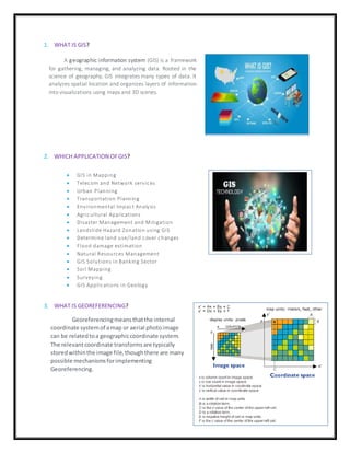
  • 1. 1. WHAT IS GIS? 2. WHICH APPLICATION OFGIS? 3. WHAT IS GEOREFERENCING? A geographic information system (GIS) is a framework for gathering, managing, and analyzing data. Rooted in the science of geography, GIS integrates many types of data. It analyzes spatial location and organizes layers of information into visualizations using maps and 3D scenes.  GIS in Mapping  Telecom and Network services  Urban Planning  Transportation Planning  Environmental Impact Analysis  Agricultural Applications  Disaster Management and Mitigation  Landslide Hazard Zonation using GIS  Determine land use/land cover changes  Flood damage estimation  Natural Resources Management  GIS Solutions in Banking Sector  Soil Mapping  Surveying  GIS Applications in Geology Georeferencingmeansthatthe internal coordinate systemof amap or aerial photoimage can be relatedtoa geographiccoordinate system. The relevantcoordinate transformsare typically storedwithinthe image file,thoughthere are many possible mechanismsforimplementing Georeferencing.
  • 2. 4. WHICH COMPONENTSOFGIS? 5. WHAT IS LAYERSTACK? 6. WHAT IS TOPOLOGY? 7. WHAT IS DATA ATTRIBUTE? Attribute data is defined as information used to create control charts. This data can be used to create many different chart systems, includingpercent charts, charts show casing the number of affected units, count-per-unit charts, demerit charts, and quality score charts. Working GIs integrates five key components: hardware,software,data,people, and methods.Hardware is the computer on which a GIS operates. Today, GIS software runs on a wide range of hardware types,from centralized computer servers to desktop computers used in stand-alone or networked configurations. Layer stacking is a process for combining multiple images into a single image. In order to do that the images should have the same extent (number of rows and number of columns), which means you will need to resample other bands which have different spatial resolution to the target resolution. Topology is the mathematical study of the properties that are preserved through deformations, twisting and stretching of object. Tearing, However is not allowed. A circle is topologically Equivalent to an Ellipse and a sphere is Equivalent to ellipsoid. There are 5 types of topology ----  Mesh  Star  Bus  Ring  hybrid
  • 3. 8. HOW TO CRATE SHAPEFILFIN ARCMAP? 9. HOW TO SET COORDINATESYSTEMIN ARCMAP? A shape fileis an Esri vector data storage format for storing the location, shape, and attributes of geographic features. It is stored as a set of related files and contains one feature class. In geometry, a coordinate system is a system that uses one or more numbers, or coordinates, to uniquely determine the position of the points or other geometric elements on a manifold such as Euclidean space. EX: INDIA Coordinate system 42 – 47◦N Degree