SlideShare a Scribd company logo
1 of 16
Download to read offline
RASTER AND VECTOR DATA FORMATS
GIUSEPPE MASETTI
ESCI 872 – APPLIED TOOLS FOR OCEAN MAPPING – INTRODUCTION TO OCEAN DATA SCIENCE
Durham, NH – September 10, 2019
V1
TWO WAYS TO REPRESENT THE WORLD
• Field Approach
• Continuous data without well-defined boundaries
• Data smoothly transition from one value to another
• Discrete-objects Approach
• Objects at fixed locations with distinct boundaries
• Data usually represented in vector format:
POINT LINE POLYGON
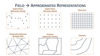
FIELD → APPROXIMATED REPRESENTATIONS
SAMPLE POINTS
(IRREGULARLY SPACED)
SAMPLE POINTS
(REGULARLY SPACED)
NODE CELLS
TRIANGULATED IRREGULAR
NETWORK (TIN)
POLYGONS
(IRREGULARLY SHAPED)
CONTOURS
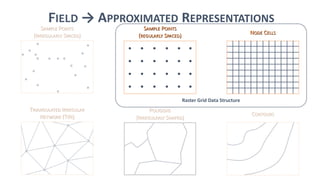
FIELD → APPROXIMATED REPRESENTATIONS
SAMPLE POINTS
(IRREGULARLY SPACED)
SAMPLE POINTS
(REGULARLY SPACED)
NODE CELLS
TRIANGULATED IRREGULAR
NETWORK (TIN)
POLYGONS
(IRREGULARLY SHAPED)
CONTOURS
Raster Grid Data Structure
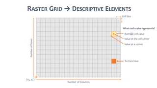
RASTER GRID → DESCRIPTIVE ELEMENTS
Number of Columns
NumberofRows
(𝑥0, 𝑦0)
Cell Size
Average cell value
No-Data Value
Value at the cell center
Value at a corner
What each value represents?
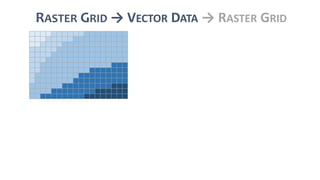
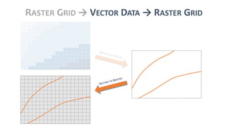
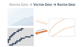
RASTER GRID → VECTOR DATA → RASTER GRID
GEOSPATIAL DATA FORMATS
RASTER VECTOR
BATHYMETRIC ATTRIBUTED GRID
ARC/INFO ASCII GRID
GEOTIFF
HDF5
GEOPACKAGE
GEOJSON
GML
IHO S57
KML
GPSBABEL
ARC/INFO BINARY GRID
CAD
ECW
ENVI
ORACLE SPATIAL GEORASTER
GMT COMPATIBLE NETCDF
GRASS RASTER
MBTILES
GEOSPATIAL PDF
RASTERLITE
XYZ
USGS ASCII DEM
MRSID
DWG
MICROSTATION DGN
ESRI FILEGDB
GPX
JML
GEORSS
GTM ASCII VECTORSGRASS VECTOR FORMAT
NETCDF
ESRI PERSONAL GEODATABASE
SPATIALITE
OSM ORACLE SPATIAL
MAPINFO TAB AND MIF/MID
SHAPEFILE
THE GEOSPATIAL DATA ABSTRACTION LIBRARY
• A translator library for raster and vector geospatial data formats
• 214+ raster formats*
• 80+ vector formats* (e.g., GeoJSON, GeoPackage, GML, IHO S57, KML, Shapefile)
• “It presents a single raster abstract data model and single vector
abstract data model to the calling application for all supported formats”
(GDAL documentation, 2019)
• C++ library with Python binding
* Values retrieved from GDAL v.2.4.1 on ePOM server.
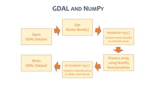
GDAL AND NUMPY
Open
GDAL Dataset
Get
Raster Band(s)
ReadAsArray()
Convert raster band(s)
to a NumPy array
Process array
using NumPy
functionalities
WriteAsArray()
Convert a NumPy array
to GDAL raster bands
Write
GDAL Dataset
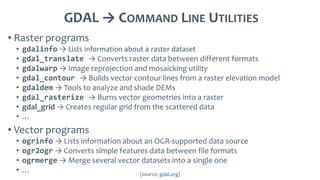
GDAL → COMMAND LINE UTILITIES
• Raster programs
• gdalinfo → Lists information about a raster dataset
• gdal_translate → Converts raster data between different formats
• gdalwarp → Image reprojection and mosaicking utility
• gdal_contour → Builds vector contour lines from a raster elevation model
• gdaldem → Tools to analyze and shade DEMs
• gdal_rasterize → Burns vector geometries into a raster
• gdal_grid → Creates regular grid from the scattered data
• …
• Vector programs
• ogrinfo → Lists information about an OGR-supported data source
• ogr2ogr → Converts simple features data between file formats
• ogrmerge → Merge several vector datasets into a single one
• … (source: gdal.org)
MODULE TASK → READ AND PLOT A BAG FILE
GO TO “INTRODUCTION TO GDAL” NOTEBOOK
QUESTIONS?
Contact me at: gmasetti@ccom.unh.edu

More Related Content

What's hot

Lect 5 data models-gis
Lect 5 data models-gisLect 5 data models-gis
Lect 5 data models-gisRehana Jamal
 
Components of Spatial Data Quality in GIS
Components of Spatial Data Quality in GISComponents of Spatial Data Quality in GIS
Components of Spatial Data Quality in GISKaium Chowdhury
 
Spatial data mining
Spatial data miningSpatial data mining
Spatial data miningMITS Gwalior
 
Geographical information system unit 3
Geographical information  system unit 3Geographical information  system unit 3
Geographical information system unit 3WE-IT TUTORIALS
 
geographic information system pdf
geographic information system pdfgeographic information system pdf
geographic information system pdfRolan Ben Lorono
 
Dmitriy Kolesov - GIS as an environment for integration and analysis of spati...
Dmitriy Kolesov - GIS as an environment for integration and analysis of spati...Dmitriy Kolesov - GIS as an environment for integration and analysis of spati...
Dmitriy Kolesov - GIS as an environment for integration and analysis of spati...AIST
 
Geographical information system unit 4
Geographical information  system unit 4Geographical information  system unit 4
Geographical information system unit 4WE-IT TUTORIALS
 
Spatial data analysis 1
Spatial data analysis 1Spatial data analysis 1
Spatial data analysis 1Johan Blomme
 
Assignment vector raster
Assignment vector rasterAssignment vector raster
Assignment vector rasterfredsk2006
 
Big Data and Geospatial with HPCC Systems
Big Data and Geospatial with HPCC SystemsBig Data and Geospatial with HPCC Systems
Big Data and Geospatial with HPCC SystemsHPCC Systems
 
4.2 spatial data mining
4.2 spatial data mining4.2 spatial data mining
4.2 spatial data miningKrish_ver2
 
Spatial Analysis and Geomatics
Spatial Analysis and GeomaticsSpatial Analysis and Geomatics
Spatial Analysis and GeomaticsRich Heimann
 

What's hot (20)

Lect 5 data models-gis
Lect 5 data models-gisLect 5 data models-gis
Lect 5 data models-gis
 
Components of Spatial Data Quality in GIS
Components of Spatial Data Quality in GISComponents of Spatial Data Quality in GIS
Components of Spatial Data Quality in GIS
 
Spatial data mining
Spatial data miningSpatial data mining
Spatial data mining
 
Geographical information system unit 3
Geographical information  system unit 3Geographical information  system unit 3
Geographical information system unit 3
 
geographic information system pdf
geographic information system pdfgeographic information system pdf
geographic information system pdf
 
Spatial databases
Spatial databasesSpatial databases
Spatial databases
 
What is gis
What is gisWhat is gis
What is gis
 
GIS Modeling
GIS ModelingGIS Modeling
GIS Modeling
 
Dmitriy Kolesov - GIS as an environment for integration and analysis of spati...
Dmitriy Kolesov - GIS as an environment for integration and analysis of spati...Dmitriy Kolesov - GIS as an environment for integration and analysis of spati...
Dmitriy Kolesov - GIS as an environment for integration and analysis of spati...
 
Georeferencing
GeoreferencingGeoreferencing
Georeferencing
 
Vector data model
Vector data modelVector data model
Vector data model
 
Spatial Data Model 2
Spatial Data Model 2Spatial Data Model 2
Spatial Data Model 2
 
GIS fundamentals - raster
GIS fundamentals - rasterGIS fundamentals - raster
GIS fundamentals - raster
 
Geographical information system unit 4
Geographical information  system unit 4Geographical information  system unit 4
Geographical information system unit 4
 
Data_Sources
Data_SourcesData_Sources
Data_Sources
 
Spatial data analysis 1
Spatial data analysis 1Spatial data analysis 1
Spatial data analysis 1
 
Assignment vector raster
Assignment vector rasterAssignment vector raster
Assignment vector raster
 
Big Data and Geospatial with HPCC Systems
Big Data and Geospatial with HPCC SystemsBig Data and Geospatial with HPCC Systems
Big Data and Geospatial with HPCC Systems
 
4.2 spatial data mining
4.2 spatial data mining4.2 spatial data mining
4.2 spatial data mining
 
Spatial Analysis and Geomatics
Spatial Analysis and GeomaticsSpatial Analysis and Geomatics
Spatial Analysis and Geomatics
 

Similar to ePOM - Intro to Ocean Data Science - Raster and Vector Data Formats

Vector data model
Vector data model Vector data model
Vector data model Pramoda Raj
 
Vector data model
Vector data modelVector data model
Vector data modelPramoda Raj
 
GRAPHITE: An Extensible Graph Traversal Framework for Relational Database Ma...
GRAPHITE:  An Extensible Graph Traversal Framework for Relational Database Ma...GRAPHITE:  An Extensible Graph Traversal Framework for Relational Database Ma...
GRAPHITE: An Extensible Graph Traversal Framework for Relational Database Ma...Marcus Paradies
 
High Dimensional Indexing using MongoDB (MongoSV 2012)
High Dimensional Indexing using MongoDB (MongoSV 2012)High Dimensional Indexing using MongoDB (MongoSV 2012)
High Dimensional Indexing using MongoDB (MongoSV 2012)Nicholas Knize, Ph.D., GISP
 
CEDAR & PRELIDA Preservation of Linked Socio-Historical Data
CEDAR & PRELIDA Preservation of Linked Socio-Historical DataCEDAR & PRELIDA Preservation of Linked Socio-Historical Data
CEDAR & PRELIDA Preservation of Linked Socio-Historical DataPRELIDA Project
 
02 Geographic scripting in uDig - halfway between user and developer
02 Geographic scripting in uDig - halfway between user and developer02 Geographic scripting in uDig - halfway between user and developer
02 Geographic scripting in uDig - halfway between user and developerAndrea Antonello
 
UG6thSem_major_GIS Data Structures.pptx DR P DAS.1.pptx
UG6thSem_major_GIS Data Structures.pptx DR P DAS.1.pptxUG6thSem_major_GIS Data Structures.pptx DR P DAS.1.pptx
UG6thSem_major_GIS Data Structures.pptx DR P DAS.1.pptxNancyVerma72
 
managing big data
managing big datamanaging big data
managing big dataSuveeksha
 
Gis and digital_map_fundamentals
Gis and digital_map_fundamentalsGis and digital_map_fundamentals
Gis and digital_map_fundamentalsSumant Diwakar
 
Follow the money with graphs
Follow the money with graphsFollow the money with graphs
Follow the money with graphsStanka Dalekova
 
Apdm 101 Arc Gis Pipeline Data Model (1)
Apdm 101 Arc Gis Pipeline Data Model  (1)Apdm 101 Arc Gis Pipeline Data Model  (1)
Apdm 101 Arc Gis Pipeline Data Model (1)David Nichter, GISP
 
Large Scale Machine Learning with Apache Spark
Large Scale Machine Learning with Apache SparkLarge Scale Machine Learning with Apache Spark
Large Scale Machine Learning with Apache SparkCloudera, Inc.
 
Covering the earth and the cloud the next generation of spatial in sql server...
Covering the earth and the cloud the next generation of spatial in sql server...Covering the earth and the cloud the next generation of spatial in sql server...
Covering the earth and the cloud the next generation of spatial in sql server...Texas Natural Resources Information System
 
DDGK: Learning Graph Representations for Deep Divergence Graph Kernels
DDGK: Learning Graph Representations for Deep Divergence Graph KernelsDDGK: Learning Graph Representations for Deep Divergence Graph Kernels
DDGK: Learning Graph Representations for Deep Divergence Graph Kernelsivaderivader
 
GIS_Whirlwind_Tour.ppt
GIS_Whirlwind_Tour.pptGIS_Whirlwind_Tour.ppt
GIS_Whirlwind_Tour.pptFatima891926
 
GIS_Whirlwind_Tour.ppt
GIS_Whirlwind_Tour.pptGIS_Whirlwind_Tour.ppt
GIS_Whirlwind_Tour.pptsafayetmim1
 
GIS_Whirlwind_Tour.ppt
GIS_Whirlwind_Tour.pptGIS_Whirlwind_Tour.ppt
GIS_Whirlwind_Tour.pptvikramvsu
 

Similar to ePOM - Intro to Ocean Data Science - Raster and Vector Data Formats (20)

Vector data model
Vector data model Vector data model
Vector data model
 
Vector data model
Vector data modelVector data model
Vector data model
 
GRAPHITE: An Extensible Graph Traversal Framework for Relational Database Ma...
GRAPHITE:  An Extensible Graph Traversal Framework for Relational Database Ma...GRAPHITE:  An Extensible Graph Traversal Framework for Relational Database Ma...
GRAPHITE: An Extensible Graph Traversal Framework for Relational Database Ma...
 
High Dimensional Indexing using MongoDB (MongoSV 2012)
High Dimensional Indexing using MongoDB (MongoSV 2012)High Dimensional Indexing using MongoDB (MongoSV 2012)
High Dimensional Indexing using MongoDB (MongoSV 2012)
 
CEDAR & PRELIDA Preservation of Linked Socio-Historical Data
CEDAR & PRELIDA Preservation of Linked Socio-Historical DataCEDAR & PRELIDA Preservation of Linked Socio-Historical Data
CEDAR & PRELIDA Preservation of Linked Socio-Historical Data
 
02 Geographic scripting in uDig - halfway between user and developer
02 Geographic scripting in uDig - halfway between user and developer02 Geographic scripting in uDig - halfway between user and developer
02 Geographic scripting in uDig - halfway between user and developer
 
UG6thSem_major_GIS Data Structures.pptx DR P DAS.1.pptx
UG6thSem_major_GIS Data Structures.pptx DR P DAS.1.pptxUG6thSem_major_GIS Data Structures.pptx DR P DAS.1.pptx
UG6thSem_major_GIS Data Structures.pptx DR P DAS.1.pptx
 
managing big data
managing big datamanaging big data
managing big data
 
Gis and digital_map_fundamentals
Gis and digital_map_fundamentalsGis and digital_map_fundamentals
Gis and digital_map_fundamentals
 
Follow the money with graphs
Follow the money with graphsFollow the money with graphs
Follow the money with graphs
 
Apdm 101 Arc Gis Pipeline Data Model (1)
Apdm 101 Arc Gis Pipeline Data Model  (1)Apdm 101 Arc Gis Pipeline Data Model  (1)
Apdm 101 Arc Gis Pipeline Data Model (1)
 
Large Scale Machine Learning with Apache Spark
Large Scale Machine Learning with Apache SparkLarge Scale Machine Learning with Apache Spark
Large Scale Machine Learning with Apache Spark
 
Covering the earth and the cloud the next generation of spatial in sql server...
Covering the earth and the cloud the next generation of spatial in sql server...Covering the earth and the cloud the next generation of spatial in sql server...
Covering the earth and the cloud the next generation of spatial in sql server...
 
Essentials of R
Essentials of REssentials of R
Essentials of R
 
DDGK: Learning Graph Representations for Deep Divergence Graph Kernels
DDGK: Learning Graph Representations for Deep Divergence Graph KernelsDDGK: Learning Graph Representations for Deep Divergence Graph Kernels
DDGK: Learning Graph Representations for Deep Divergence Graph Kernels
 
Advancing Scientific Data Support in ArcGIS
Advancing Scientific Data Support in ArcGISAdvancing Scientific Data Support in ArcGIS
Advancing Scientific Data Support in ArcGIS
 
GIS_Whirlwind_Tour.ppt
GIS_Whirlwind_Tour.pptGIS_Whirlwind_Tour.ppt
GIS_Whirlwind_Tour.ppt
 
GIS_Whirlwind_Tour.ppt
GIS_Whirlwind_Tour.pptGIS_Whirlwind_Tour.ppt
GIS_Whirlwind_Tour.ppt
 
GIS_Whirlwind_Tour.ppt
GIS_Whirlwind_Tour.pptGIS_Whirlwind_Tour.ppt
GIS_Whirlwind_Tour.ppt
 
GIS_Whirlwind_Tour.ppt
GIS_Whirlwind_Tour.pptGIS_Whirlwind_Tour.ppt
GIS_Whirlwind_Tour.ppt
 

More from Giuseppe Masetti

Open Backscatter Toolchain (OpenBST) Project - A Community-vetted Workflow fo...
Open Backscatter Toolchain (OpenBST) Project - A Community-vetted Workflow fo...Open Backscatter Toolchain (OpenBST) Project - A Community-vetted Workflow fo...
Open Backscatter Toolchain (OpenBST) Project - A Community-vetted Workflow fo...Giuseppe Masetti
 
e-learning Python for Ocean Mapping - Empowering the next generation of ocean...
e-learning Python for Ocean Mapping - Empowering the next generation of ocean...e-learning Python for Ocean Mapping - Empowering the next generation of ocean...
e-learning Python for Ocean Mapping - Empowering the next generation of ocean...Giuseppe Masetti
 
Leveraging Predictions from NOAA’s Oceanographic Forecast Models to Increase ...
Leveraging Predictions from NOAA’s Oceanographic Forecast Models to Increase ...Leveraging Predictions from NOAA’s Oceanographic Forecast Models to Increase ...
Leveraging Predictions from NOAA’s Oceanographic Forecast Models to Increase ...Giuseppe Masetti
 
ePOM - Fundamentals of Research Software Development - Code Version Control
ePOM - Fundamentals of Research Software Development - Code Version ControlePOM - Fundamentals of Research Software Development - Code Version Control
ePOM - Fundamentals of Research Software Development - Code Version ControlGiuseppe Masetti
 
ePOM - Fundamentals of Research Software Development - Integrated Development...
ePOM - Fundamentals of Research Software Development - Integrated Development...ePOM - Fundamentals of Research Software Development - Integrated Development...
ePOM - Fundamentals of Research Software Development - Integrated Development...Giuseppe Masetti
 
ePOM - Fundamentals of Research Software Development - Introduction
ePOM - Fundamentals of Research Software Development - IntroductionePOM - Fundamentals of Research Software Development - Introduction
ePOM - Fundamentals of Research Software Development - IntroductionGiuseppe Masetti
 
ePOM - Intro to Ocean Data Science - Object-Oriented Programming
ePOM - Intro to Ocean Data Science - Object-Oriented ProgrammingePOM - Intro to Ocean Data Science - Object-Oriented Programming
ePOM - Intro to Ocean Data Science - Object-Oriented ProgrammingGiuseppe Masetti
 
AusSeabed workshop - Pydro and Hydroffice - Days 2 and 3
AusSeabed workshop - Pydro and Hydroffice - Days 2 and 3AusSeabed workshop - Pydro and Hydroffice - Days 2 and 3
AusSeabed workshop - Pydro and Hydroffice - Days 2 and 3Giuseppe Masetti
 
AusSeabed workshop - Pydro and Hydroffice - Day 1
AusSeabed workshop - Pydro and Hydroffice - Day 1AusSeabed workshop - Pydro and Hydroffice - Day 1
AusSeabed workshop - Pydro and Hydroffice - Day 1Giuseppe Masetti
 
Hydrographic Survey Validation and Chart Adequacy Assessment Using Automated ...
Hydrographic Survey Validation and Chart Adequacy Assessment Using Automated ...Hydrographic Survey Validation and Chart Adequacy Assessment Using Automated ...
Hydrographic Survey Validation and Chart Adequacy Assessment Using Automated ...Giuseppe Masetti
 
The Open Backscatter Toolchain (OpenBST) project: towards an open-source and ...
The Open Backscatter Toolchain (OpenBST) project: towards an open-source and ...The Open Backscatter Toolchain (OpenBST) project: towards an open-source and ...
The Open Backscatter Toolchain (OpenBST) project: towards an open-source and ...Giuseppe Masetti
 
Pydro & HydrOffice: Open Tools for Ocean Mappers
Pydro & HydrOffice: Open Tools for Ocean MappersPydro & HydrOffice: Open Tools for Ocean Mappers
Pydro & HydrOffice: Open Tools for Ocean MappersGiuseppe Masetti
 
INMARTECH 2018 - G.Masetti & P.Johnson - Sound Speed Management and Environme...
INMARTECH 2018 - G.Masetti & P.Johnson - Sound Speed Management and Environme...INMARTECH 2018 - G.Masetti & P.Johnson - Sound Speed Management and Environme...
INMARTECH 2018 - G.Masetti & P.Johnson - Sound Speed Management and Environme...Giuseppe Masetti
 
Backscatter Working Group Software Inter-comparison Project Requesting and Co...
Backscatter Working Group Software Inter-comparison ProjectRequesting and Co...Backscatter Working Group Software Inter-comparison ProjectRequesting and Co...
Backscatter Working Group Software Inter-comparison Project Requesting and Co...Giuseppe Masetti
 
Shallow Survey 2018 - Applications of Sonar Detection Uncertainty for Survey ...
Shallow Survey 2018 - Applications of Sonar Detection Uncertainty for Survey ...Shallow Survey 2018 - Applications of Sonar Detection Uncertainty for Survey ...
Shallow Survey 2018 - Applications of Sonar Detection Uncertainty for Survey ...Giuseppe Masetti
 
Bathymetric Attributed Grid (BAG) format
Bathymetric Attributed Grid (BAG) formatBathymetric Attributed Grid (BAG) format
Bathymetric Attributed Grid (BAG) formatGiuseppe Masetti
 
Masetti et al. - Bathymetric and reflectivity-derived data fusion for Prelimi...
Masetti et al. - Bathymetric and reflectivity-derived data fusion for Prelimi...Masetti et al. - Bathymetric and reflectivity-derived data fusion for Prelimi...
Masetti et al. - Bathymetric and reflectivity-derived data fusion for Prelimi...Giuseppe Masetti
 
HydrOffice: past, present, and future.
HydrOffice: past, present, and future.HydrOffice: past, present, and future.
HydrOffice: past, present, and future.Giuseppe Masetti
 

More from Giuseppe Masetti (18)

Open Backscatter Toolchain (OpenBST) Project - A Community-vetted Workflow fo...
Open Backscatter Toolchain (OpenBST) Project - A Community-vetted Workflow fo...Open Backscatter Toolchain (OpenBST) Project - A Community-vetted Workflow fo...
Open Backscatter Toolchain (OpenBST) Project - A Community-vetted Workflow fo...
 
e-learning Python for Ocean Mapping - Empowering the next generation of ocean...
e-learning Python for Ocean Mapping - Empowering the next generation of ocean...e-learning Python for Ocean Mapping - Empowering the next generation of ocean...
e-learning Python for Ocean Mapping - Empowering the next generation of ocean...
 
Leveraging Predictions from NOAA’s Oceanographic Forecast Models to Increase ...
Leveraging Predictions from NOAA’s Oceanographic Forecast Models to Increase ...Leveraging Predictions from NOAA’s Oceanographic Forecast Models to Increase ...
Leveraging Predictions from NOAA’s Oceanographic Forecast Models to Increase ...
 
ePOM - Fundamentals of Research Software Development - Code Version Control
ePOM - Fundamentals of Research Software Development - Code Version ControlePOM - Fundamentals of Research Software Development - Code Version Control
ePOM - Fundamentals of Research Software Development - Code Version Control
 
ePOM - Fundamentals of Research Software Development - Integrated Development...
ePOM - Fundamentals of Research Software Development - Integrated Development...ePOM - Fundamentals of Research Software Development - Integrated Development...
ePOM - Fundamentals of Research Software Development - Integrated Development...
 
ePOM - Fundamentals of Research Software Development - Introduction
ePOM - Fundamentals of Research Software Development - IntroductionePOM - Fundamentals of Research Software Development - Introduction
ePOM - Fundamentals of Research Software Development - Introduction
 
ePOM - Intro to Ocean Data Science - Object-Oriented Programming
ePOM - Intro to Ocean Data Science - Object-Oriented ProgrammingePOM - Intro to Ocean Data Science - Object-Oriented Programming
ePOM - Intro to Ocean Data Science - Object-Oriented Programming
 
AusSeabed workshop - Pydro and Hydroffice - Days 2 and 3
AusSeabed workshop - Pydro and Hydroffice - Days 2 and 3AusSeabed workshop - Pydro and Hydroffice - Days 2 and 3
AusSeabed workshop - Pydro and Hydroffice - Days 2 and 3
 
AusSeabed workshop - Pydro and Hydroffice - Day 1
AusSeabed workshop - Pydro and Hydroffice - Day 1AusSeabed workshop - Pydro and Hydroffice - Day 1
AusSeabed workshop - Pydro and Hydroffice - Day 1
 
Hydrographic Survey Validation and Chart Adequacy Assessment Using Automated ...
Hydrographic Survey Validation and Chart Adequacy Assessment Using Automated ...Hydrographic Survey Validation and Chart Adequacy Assessment Using Automated ...
Hydrographic Survey Validation and Chart Adequacy Assessment Using Automated ...
 
The Open Backscatter Toolchain (OpenBST) project: towards an open-source and ...
The Open Backscatter Toolchain (OpenBST) project: towards an open-source and ...The Open Backscatter Toolchain (OpenBST) project: towards an open-source and ...
The Open Backscatter Toolchain (OpenBST) project: towards an open-source and ...
 
Pydro & HydrOffice: Open Tools for Ocean Mappers
Pydro & HydrOffice: Open Tools for Ocean MappersPydro & HydrOffice: Open Tools for Ocean Mappers
Pydro & HydrOffice: Open Tools for Ocean Mappers
 
INMARTECH 2018 - G.Masetti & P.Johnson - Sound Speed Management and Environme...
INMARTECH 2018 - G.Masetti & P.Johnson - Sound Speed Management and Environme...INMARTECH 2018 - G.Masetti & P.Johnson - Sound Speed Management and Environme...
INMARTECH 2018 - G.Masetti & P.Johnson - Sound Speed Management and Environme...
 
Backscatter Working Group Software Inter-comparison Project Requesting and Co...
Backscatter Working Group Software Inter-comparison ProjectRequesting and Co...Backscatter Working Group Software Inter-comparison ProjectRequesting and Co...
Backscatter Working Group Software Inter-comparison Project Requesting and Co...
 
Shallow Survey 2018 - Applications of Sonar Detection Uncertainty for Survey ...
Shallow Survey 2018 - Applications of Sonar Detection Uncertainty for Survey ...Shallow Survey 2018 - Applications of Sonar Detection Uncertainty for Survey ...
Shallow Survey 2018 - Applications of Sonar Detection Uncertainty for Survey ...
 
Bathymetric Attributed Grid (BAG) format
Bathymetric Attributed Grid (BAG) formatBathymetric Attributed Grid (BAG) format
Bathymetric Attributed Grid (BAG) format
 
Masetti et al. - Bathymetric and reflectivity-derived data fusion for Prelimi...
Masetti et al. - Bathymetric and reflectivity-derived data fusion for Prelimi...Masetti et al. - Bathymetric and reflectivity-derived data fusion for Prelimi...
Masetti et al. - Bathymetric and reflectivity-derived data fusion for Prelimi...
 
HydrOffice: past, present, and future.
HydrOffice: past, present, and future.HydrOffice: past, present, and future.
HydrOffice: past, present, and future.
 

Recently uploaded

Climate Change Impacts on Terrestrial and Aquatic Ecosystems.pptx
Climate Change Impacts on Terrestrial and Aquatic Ecosystems.pptxClimate Change Impacts on Terrestrial and Aquatic Ecosystems.pptx
Climate Change Impacts on Terrestrial and Aquatic Ecosystems.pptxDiariAli
 
COMPOSTING : types of compost, merits and demerits
COMPOSTING : types of compost, merits and demeritsCOMPOSTING : types of compost, merits and demerits
COMPOSTING : types of compost, merits and demeritsCherry
 
GBSN - Biochemistry (Unit 2) Basic concept of organic chemistry
GBSN - Biochemistry (Unit 2) Basic concept of organic chemistry GBSN - Biochemistry (Unit 2) Basic concept of organic chemistry
GBSN - Biochemistry (Unit 2) Basic concept of organic chemistry Areesha Ahmad
 
module for grade 9 for distance learning
module for grade 9 for distance learningmodule for grade 9 for distance learning
module for grade 9 for distance learninglevieagacer
 
Cyanide resistant respiration pathway.pptx
Cyanide resistant respiration pathway.pptxCyanide resistant respiration pathway.pptx
Cyanide resistant respiration pathway.pptxCherry
 
Understanding Partial Differential Equations: Types and Solution Methods
Understanding Partial Differential Equations: Types and Solution MethodsUnderstanding Partial Differential Equations: Types and Solution Methods
Understanding Partial Differential Equations: Types and Solution Methodsimroshankoirala
 
Genome sequencing,shotgun sequencing.pptx
Genome sequencing,shotgun sequencing.pptxGenome sequencing,shotgun sequencing.pptx
Genome sequencing,shotgun sequencing.pptxCherry
 
Porella : features, morphology, anatomy, reproduction etc.
Porella : features, morphology, anatomy, reproduction etc.Porella : features, morphology, anatomy, reproduction etc.
Porella : features, morphology, anatomy, reproduction etc.Cherry
 
Digital Dentistry.Digital Dentistryvv.pptx
Digital Dentistry.Digital Dentistryvv.pptxDigital Dentistry.Digital Dentistryvv.pptx
Digital Dentistry.Digital Dentistryvv.pptxMohamedFarag457087
 
Efficient spin-up of Earth System Models usingsequence acceleration
Efficient spin-up of Earth System Models usingsequence accelerationEfficient spin-up of Earth System Models usingsequence acceleration
Efficient spin-up of Earth System Models usingsequence accelerationSérgio Sacani
 
Module for Grade 9 for Asynchronous/Distance learning
Module for Grade 9 for Asynchronous/Distance learningModule for Grade 9 for Asynchronous/Distance learning
Module for Grade 9 for Asynchronous/Distance learninglevieagacer
 
Role of AI in seed science Predictive modelling and Beyond.pptx
Role of AI in seed science  Predictive modelling and  Beyond.pptxRole of AI in seed science  Predictive modelling and  Beyond.pptx
Role of AI in seed science Predictive modelling and Beyond.pptxArvind Kumar
 
The Mariana Trench remarkable geological features on Earth.pptx
The Mariana Trench remarkable geological features on Earth.pptxThe Mariana Trench remarkable geological features on Earth.pptx
The Mariana Trench remarkable geological features on Earth.pptxseri bangash
 
Human genetics..........................pptx
Human genetics..........................pptxHuman genetics..........................pptx
Human genetics..........................pptxCherry
 
Cot curve, melting temperature, unique and repetitive DNA
Cot curve, melting temperature, unique and repetitive DNACot curve, melting temperature, unique and repetitive DNA
Cot curve, melting temperature, unique and repetitive DNACherry
 
FS P2 COMBO MSTA LAST PUSH past exam papers.
FS P2 COMBO MSTA LAST PUSH past exam papers.FS P2 COMBO MSTA LAST PUSH past exam papers.
FS P2 COMBO MSTA LAST PUSH past exam papers.takadzanijustinmaime
 
CURRENT SCENARIO OF POULTRY PRODUCTION IN INDIA
CURRENT SCENARIO OF POULTRY PRODUCTION IN INDIACURRENT SCENARIO OF POULTRY PRODUCTION IN INDIA
CURRENT SCENARIO OF POULTRY PRODUCTION IN INDIADr. TATHAGAT KHOBRAGADE
 
Cyathodium bryophyte: morphology, anatomy, reproduction etc.
Cyathodium bryophyte: morphology, anatomy, reproduction etc.Cyathodium bryophyte: morphology, anatomy, reproduction etc.
Cyathodium bryophyte: morphology, anatomy, reproduction etc.Cherry
 
Use of mutants in understanding seedling development.pptx
Use of mutants in understanding seedling development.pptxUse of mutants in understanding seedling development.pptx
Use of mutants in understanding seedling development.pptxRenuJangid3
 

Recently uploaded (20)

Climate Change Impacts on Terrestrial and Aquatic Ecosystems.pptx
Climate Change Impacts on Terrestrial and Aquatic Ecosystems.pptxClimate Change Impacts on Terrestrial and Aquatic Ecosystems.pptx
Climate Change Impacts on Terrestrial and Aquatic Ecosystems.pptx
 
COMPOSTING : types of compost, merits and demerits
COMPOSTING : types of compost, merits and demeritsCOMPOSTING : types of compost, merits and demerits
COMPOSTING : types of compost, merits and demerits
 
GBSN - Biochemistry (Unit 2) Basic concept of organic chemistry
GBSN - Biochemistry (Unit 2) Basic concept of organic chemistry GBSN - Biochemistry (Unit 2) Basic concept of organic chemistry
GBSN - Biochemistry (Unit 2) Basic concept of organic chemistry
 
module for grade 9 for distance learning
module for grade 9 for distance learningmodule for grade 9 for distance learning
module for grade 9 for distance learning
 
Cyanide resistant respiration pathway.pptx
Cyanide resistant respiration pathway.pptxCyanide resistant respiration pathway.pptx
Cyanide resistant respiration pathway.pptx
 
Understanding Partial Differential Equations: Types and Solution Methods
Understanding Partial Differential Equations: Types and Solution MethodsUnderstanding Partial Differential Equations: Types and Solution Methods
Understanding Partial Differential Equations: Types and Solution Methods
 
Genome sequencing,shotgun sequencing.pptx
Genome sequencing,shotgun sequencing.pptxGenome sequencing,shotgun sequencing.pptx
Genome sequencing,shotgun sequencing.pptx
 
Porella : features, morphology, anatomy, reproduction etc.
Porella : features, morphology, anatomy, reproduction etc.Porella : features, morphology, anatomy, reproduction etc.
Porella : features, morphology, anatomy, reproduction etc.
 
ABHISHEK ANTIBIOTICS PPT MICROBIOLOGY // USES OF ANTIOBIOTICS TYPES OF ANTIB...
ABHISHEK ANTIBIOTICS PPT MICROBIOLOGY  // USES OF ANTIOBIOTICS TYPES OF ANTIB...ABHISHEK ANTIBIOTICS PPT MICROBIOLOGY  // USES OF ANTIOBIOTICS TYPES OF ANTIB...
ABHISHEK ANTIBIOTICS PPT MICROBIOLOGY // USES OF ANTIOBIOTICS TYPES OF ANTIB...
 
Digital Dentistry.Digital Dentistryvv.pptx
Digital Dentistry.Digital Dentistryvv.pptxDigital Dentistry.Digital Dentistryvv.pptx
Digital Dentistry.Digital Dentistryvv.pptx
 
Efficient spin-up of Earth System Models usingsequence acceleration
Efficient spin-up of Earth System Models usingsequence accelerationEfficient spin-up of Earth System Models usingsequence acceleration
Efficient spin-up of Earth System Models usingsequence acceleration
 
Module for Grade 9 for Asynchronous/Distance learning
Module for Grade 9 for Asynchronous/Distance learningModule for Grade 9 for Asynchronous/Distance learning
Module for Grade 9 for Asynchronous/Distance learning
 
Role of AI in seed science Predictive modelling and Beyond.pptx
Role of AI in seed science  Predictive modelling and  Beyond.pptxRole of AI in seed science  Predictive modelling and  Beyond.pptx
Role of AI in seed science Predictive modelling and Beyond.pptx
 
The Mariana Trench remarkable geological features on Earth.pptx
The Mariana Trench remarkable geological features on Earth.pptxThe Mariana Trench remarkable geological features on Earth.pptx
The Mariana Trench remarkable geological features on Earth.pptx
 
Human genetics..........................pptx
Human genetics..........................pptxHuman genetics..........................pptx
Human genetics..........................pptx
 
Cot curve, melting temperature, unique and repetitive DNA
Cot curve, melting temperature, unique and repetitive DNACot curve, melting temperature, unique and repetitive DNA
Cot curve, melting temperature, unique and repetitive DNA
 
FS P2 COMBO MSTA LAST PUSH past exam papers.
FS P2 COMBO MSTA LAST PUSH past exam papers.FS P2 COMBO MSTA LAST PUSH past exam papers.
FS P2 COMBO MSTA LAST PUSH past exam papers.
 
CURRENT SCENARIO OF POULTRY PRODUCTION IN INDIA
CURRENT SCENARIO OF POULTRY PRODUCTION IN INDIACURRENT SCENARIO OF POULTRY PRODUCTION IN INDIA
CURRENT SCENARIO OF POULTRY PRODUCTION IN INDIA
 
Cyathodium bryophyte: morphology, anatomy, reproduction etc.
Cyathodium bryophyte: morphology, anatomy, reproduction etc.Cyathodium bryophyte: morphology, anatomy, reproduction etc.
Cyathodium bryophyte: morphology, anatomy, reproduction etc.
 
Use of mutants in understanding seedling development.pptx
Use of mutants in understanding seedling development.pptxUse of mutants in understanding seedling development.pptx
Use of mutants in understanding seedling development.pptx
 

ePOM - Intro to Ocean Data Science - Raster and Vector Data Formats

  • 1. RASTER AND VECTOR DATA FORMATS GIUSEPPE MASETTI ESCI 872 – APPLIED TOOLS FOR OCEAN MAPPING – INTRODUCTION TO OCEAN DATA SCIENCE Durham, NH – September 10, 2019 V1
  • 2. TWO WAYS TO REPRESENT THE WORLD • Field Approach • Continuous data without well-defined boundaries • Data smoothly transition from one value to another • Discrete-objects Approach • Objects at fixed locations with distinct boundaries • Data usually represented in vector format: POINT LINE POLYGON
  • 3. FIELD → APPROXIMATED REPRESENTATIONS SAMPLE POINTS (IRREGULARLY SPACED) SAMPLE POINTS (REGULARLY SPACED) NODE CELLS TRIANGULATED IRREGULAR NETWORK (TIN) POLYGONS (IRREGULARLY SHAPED) CONTOURS
  • 4. FIELD → APPROXIMATED REPRESENTATIONS SAMPLE POINTS (IRREGULARLY SPACED) SAMPLE POINTS (REGULARLY SPACED) NODE CELLS TRIANGULATED IRREGULAR NETWORK (TIN) POLYGONS (IRREGULARLY SHAPED) CONTOURS Raster Grid Data Structure
  • 5. RASTER GRID → DESCRIPTIVE ELEMENTS Number of Columns NumberofRows (𝑥0, 𝑦0) Cell Size Average cell value No-Data Value Value at the cell center Value at a corner What each value represents?
  • 6. RASTER GRID → VECTOR DATA → RASTER GRID
  • 7. RASTER GRID → VECTOR DATA → RASTER GRID
  • 8. RASTER GRID → VECTOR DATA → RASTER GRID
  • 9. RASTER GRID → VECTOR DATA → RASTER GRID
  • 10. GEOSPATIAL DATA FORMATS RASTER VECTOR BATHYMETRIC ATTRIBUTED GRID ARC/INFO ASCII GRID GEOTIFF HDF5 GEOPACKAGE GEOJSON GML IHO S57 KML GPSBABEL ARC/INFO BINARY GRID CAD ECW ENVI ORACLE SPATIAL GEORASTER GMT COMPATIBLE NETCDF GRASS RASTER MBTILES GEOSPATIAL PDF RASTERLITE XYZ USGS ASCII DEM MRSID DWG MICROSTATION DGN ESRI FILEGDB GPX JML GEORSS GTM ASCII VECTORSGRASS VECTOR FORMAT NETCDF ESRI PERSONAL GEODATABASE SPATIALITE OSM ORACLE SPATIAL MAPINFO TAB AND MIF/MID SHAPEFILE
  • 11. THE GEOSPATIAL DATA ABSTRACTION LIBRARY • A translator library for raster and vector geospatial data formats • 214+ raster formats* • 80+ vector formats* (e.g., GeoJSON, GeoPackage, GML, IHO S57, KML, Shapefile) • “It presents a single raster abstract data model and single vector abstract data model to the calling application for all supported formats” (GDAL documentation, 2019) • C++ library with Python binding * Values retrieved from GDAL v.2.4.1 on ePOM server.
  • 12. GDAL AND NUMPY Open GDAL Dataset Get Raster Band(s) ReadAsArray() Convert raster band(s) to a NumPy array Process array using NumPy functionalities WriteAsArray() Convert a NumPy array to GDAL raster bands Write GDAL Dataset
  • 13. GDAL → COMMAND LINE UTILITIES • Raster programs • gdalinfo → Lists information about a raster dataset • gdal_translate → Converts raster data between different formats • gdalwarp → Image reprojection and mosaicking utility • gdal_contour → Builds vector contour lines from a raster elevation model • gdaldem → Tools to analyze and shade DEMs • gdal_rasterize → Burns vector geometries into a raster • gdal_grid → Creates regular grid from the scattered data • … • Vector programs • ogrinfo → Lists information about an OGR-supported data source • ogr2ogr → Converts simple features data between file formats • ogrmerge → Merge several vector datasets into a single one • … (source: gdal.org)
  • 14. MODULE TASK → READ AND PLOT A BAG FILE
  • 15. GO TO “INTRODUCTION TO GDAL” NOTEBOOK
  • 16. QUESTIONS? Contact me at: gmasetti@ccom.unh.edu