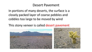
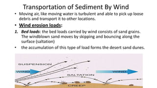
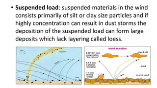
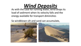
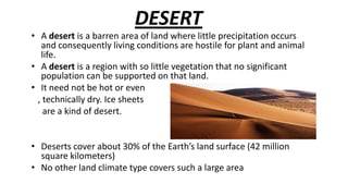
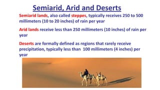
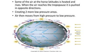
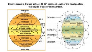
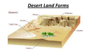
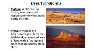
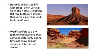
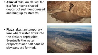
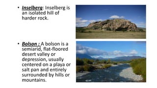
DESERT

‱ A desert is a barren area of land where little precipitation occurs
and consequently living conditions are hostile for plant and animal
life.
‱ A desert is a region with so little vegetation that no significant
population can be supported on that land.
‱ It need not be hot or even
, technically dry. Ice sheets
are a kind of desert.
‱ Deserts cover about 30% of the Earth’s land surface (42 million
square kilometers)
‱ No other land climate type covers such a large area
Semiarid, Arid and Deserts
Semiarid lands, also called steppes, typically receives 250 to 500
millimeters (10 to 20 inches) of rain per year
Arid lands receive less than 250 millimeters (10 inches) of rain per
year
Deserts are formally defined as regions that rarely receive
precipitation, typically less than 100 millimeters (4 inches) per
year
Within water deficient regions two climatic types are commonly
recognized.

DESERT

‱ Desert which is arid.
‱ A desert is a dry, often
sandy region of little
rainfall, extreme
temperatures, and sparse
vegetation.

STEPPE

‱ Steppe which is semiarid.
‱ The steppe is a marginal and
more humid variant of the desert
and is a transition zone that
surrounds the dessert and
separates it from bordering
humid climates.
Causes Of Natural Deserts
A variety of factors contribute to the formation
of desert, so desert come in several different
types , depending on their origins.

High surface temperature
2. Topography
1.
1. High surface temperature
‱ Most vegetation, under such conditions,
requires abundant rainfall and or slow
evaporation of what precipitation does fall.
‱ The availability of precipitation is governed, in
part by the Global Circulation Pattern.
‱ Warm air holds more moisture than cold.
‱ Global distribution of air pressure and wind is
cause of formation of deserts.
Global circulation pattern
‱ Some of the air at the horse latitudes is heated and
rises. When the air reaches the tropopause it is pushed
in opposite directions.
‱ Creating 2 more low pressure areas.
‱ Air then moves from high pressure to low pressure.
Global Circulation Pattern
‱ Solar radiations falls most directly on the earth near the
equator and consequently, solar heating of the
atmosphere and surface more intense there the sun
rays are most dispersed near the poles.
‱ The air over the equatorial regions would be warmer
than the air over the poles.
‱ Heated air rises creating low pressure at earth surface.
‱ Rising air hits the tropopause move pole ward begins to
cool.
‱ Falling air accumulates and create a high pressure
system.
‱ Some of this fallen air continues pole ward until it is
heated again and some of air returns.
‱ Warm air holds more moisture than cold. Similarly, when the
pressure on a mass of air is increased, the air can hold more
moisture.
‱ Air spreading outward from the equator at high altitudes is
chilled an at low pressure, since air pressure and temperature
decrease with increasing altitudes.
‱ Thus the air holds little moisture when that air circulates
downward, at about 30 degrees north and south latitudes, it is
warmed as it approaches the surface, and also subjected to
increasing pressure from the deepening column of air above
it. It can then hold considerably more water, so when it
reaches earth’s surface. It cause rapid evaporation.
‱ Thus many of the World’s major deserts fall in belts close to
these zones of sinking air at 30 degrees north and south of the
equator, these are the tropical/ latitudes deserts.
2.Topography
‱ Many desert in the middle latitudes are rains
shadow deserts. As moving air meats a mountain
barrier, it is forced to rise.
‱ Clouds and precipitation windward side often
result. Air descending the leeward side is much
drier. The mountains effectively cut the leeward
side off from the sources of moisture, producing a
rain shadow desert.
‱ The great basin desert is a rain shadow that covers
nearly all of Nevada and adjacent states.
‱

‱

‱

‱

On the other hand even coastal areas can have
desert under special circumstances.
If the land is hot and adjacent ocean cooled by
cold currents, the moist air coming off the ocean
will be cool and carry less moisture.
Then air over a warmer ocean as the cooler air
warms over the land and becomes capable of
holding still more moisture,
It causes rapid evaporation from the land rather
than precipitation.
This phenomenon is observed along portion of the
western coasts of Africa and south America.
Deserts occurs in 2 broad belts, at 20-30o north and south of the Equator, along
the Tropics of Cancer and Capricorn.
Types of Desert
1. TRADE WIND DESERT An area of very little rainfall and high
temperature that occurs where the trade winds or their
equivalent blow over land. (linear dune)
‱ The best examples are the Sahara and Kalahari deserts. The
trade winds blowing from higher latitudes are very drying,
and cloudiness is almost absent in these desert regions. (57
degrees)
2. Midlatitude deserts : Midlatitude deserts occur between 30° and
50° N. and S., pole ward of the subtropical high pressure
zones.These deserts are in interior drainage basins far from
oceans and have a wide range of annual temperatures.
‱ The Sonoran Desert of southwestern North America is a typical
midlatitude desert.(ripples, small blowouts)
3.Rain Shadow desert: Rain shadow deserts are formed
because tall mountain ranges prevent moisture-rich
clouds from reaching areas on the lee, or protected
side, of the range. As air rises over the mountain, water
is precipitated and the air loses its moisture content. A
desert is formed in the leeside "shadow" of the
range.(Tian Shan of China)
4. Coastal deserts: Coastal deserts generally are found on the western
edges of continents near the Tropics of Cancer and Capricorn. They
are affected by cold ocean currents that parallel the coast. Because
local wind systems dominate the trade winds, these deserts are less
stable than other deserts. Winter fogs, produced by upwelling cold
currents, frequently blanket coastal deserts and block solar radiation.
A coastal desert, the Atacama of South America, is the Earth's driest
desert.(Crescent-shaped dunes in Namib, Africa)
5. Monsoon desert : Monsoons develop in response to
temperature variations between continents and oceans. The
southeast trade winds of the Indian Ocean, for example,
provide heavy summer rains in India as they move onshore. As
the monsoon crosses India, it loses moisture on the eastern
slopes of the Aravalli Range.The Rajasthan Desert of India and
the Thar Desert of Pakistan are parts of a monsoon desert
region west of the range.(small patches of sand sheets)
6. Polar desert: Polar deserts can also be attributed to the
differences in moisture holding capacities between warm and
cold air. Air travelling from warmer latitudes to colder near
polar ones will tend to lose moisture by precipitation ,so less
remains to fall as snow near the poles, and the limited
evaporation from cold high latitudes oceans contributes little
additional moisture to enhance local precipitation. Thick polar
ice caps, then , reflect effective preservation of what snow
does fall, rather than heavy precipitation. sand dunes are not
prominent, but snow dunes occur in those areas where
precipitation is more abundant. (mostly bedrock or gravel
plains)
Desert Land Forms
Desert landforms
‱ Plateau: A plateau is a
broad, level, elevated
region commonly bounded
partly by cliffs.

‱ Mesa: A mesa is the
American English term for
tableland, an elevated area
of land with a flat top and
sides that are usually steep
cliffs.
‱ Butte: is an isolated hill
with steep, often vertical
sides and a small, relatively
flat top; buttes are smaller
than mesas, plateaus, and
table landforms.

‱ Wadi: It refers to a dry
(ephemeral) riverbed that
contains water only during
times of heavy rain or
simply an intermittent
stream.
‱ Alluvial fans: An alluvial fan
is a fan or cone-shaped
deposit of sediment crossed
and built up by streams.

‱ Playa lakes: an temporary
lake where water flows into
the dessert depression.
Eventually the water
evaporates and salt pans or
clay pans are formed.
‱ Inselberg: Inselberg is
an isolated hill of
harder rock.

‱ Bolson : A bolson is a
semiarid, flat-floored
desert valley or
depression, usually
centered on a playa or
salt pan and entirely
surrounded by hills or
mountains.
‱ Arch: is a natural rock
formation where a rock arch
forms, with an opening
underneath.

‱ Escarpment: An escarpment
is a steep slope or long cliff
that occurs from faulting and
resulting erosion and
separates two relatively level
areas of differing elevations.
‱ Oasis: is an isolated
area of vegetation
in a desert typically
surrounding a
spring or similar
water source. Oasis
also provide habitat
for animals and
even humans if the
area is big enough.
Processes affecting landform shapes
‱ weathering, erosion, and deposition are a main force behind
landscape types
‱ But they are not the only reason for a plain, plateau, and
mountain region to form.
‱ Other factors such as glaciation and tectonic activity lead to
landscape building
‱ the water cycle or hydrologic cycle is the driving force
‱ winds also help form the surface landscape
‱ But without gravity and the sun this whole process would
not occur.
‱ Erosion
Erosion is the process by which soil and
rock are removed from the Earth's
surface by exogenetic processes such as
wind or water flow, and then
transported and deposited in other
locations.
‱ Wind erosion: consists of Abrasion &
Deflation.
Wind abrasion: is the wearing away of a solid object by the
impact of particles carried by winds. It is a sort of natural sandblasting.
‱ Abrasion creates interestingly shaped stones called Ventifacts
and Yardangs.
‱ Vent facts: are rocks that are polished and shaped by sand
blasting (abrasion).
‱ Yardangs: Yardangs are usually small, wind
sculpted landforms that are aligned parallel with
the wind. Individual yardangs are generally small
features that stands less than 5 meters high and
no more than about 10 meters.
‱ Deflation : is the wholesale removal of loose sediments,
usually fine-grained sediment, by the wind.
‱ The resulting surface after deflation is called Desert
pavement and Blowouts.
‱ Desert pavement: consists of a closely packed veneer of
pebbles and cobbles that is only one or two stones thick.
Beneath the pavement is material containing a
significant proportion of finer particles.
‱ Blowouts: a blowout or deflation hollow is a

depression excavated by the wind in easily eroded
materials such as sand or silt deposits with little or
no moisture or vegetation content--vegetation
present in materials at the surface impedes deflation.
Desert Pavement
In portions of many deserts, the surface is a
closely packed layer of coarse pebbles and
cobbles too large to be moved by wind
This stony veneer is called desert pavement
Transportation of Sediment By Wind
‱ Moving air, like moving water is turbulent and able to pick up loose
debris and transport it to other locations.

‱ Wind erosion loads:
1. Bed loads: the bed loads carried by wind consists of sand grains.
The windblown sand moves by skipping and bouncing along the
surface (saltation)
‱ the accumulation of this type of load forms the desert sand dunes.
‱ Suspended load: suspended materials in the wind
consists primarily of silt or clay size particles and if
highly concentration can result in dust storms the
deposition of the suspended load can form large
deposits which lack layering called loess.
Wind Depositsdrops its
As with the case for running water, wind
load of sediment when its velocity falls and the
energy available for transport diminishes
So windblown silt and sand can accumulate,
forming distinctive geologic features.
Loess
A deposit of windblown dust is called loess
The fine dust in loess is typically only 0.01 to 0.06
millimeter (0.0004 to 0.0024 inch) in diameter

There are two primary sources for loess deposits:
Deserts

Glacial outwash deposits
Desert Loess in China
Homes, called yaodongs, are created by digging into the loess
In the dry desert, these structures can last for many centuries
Windblown Sand
Where sand is transported and later deposited by wind, the principle
depositional feature is called a dune (or sand dune)
Sand dunes form when there is
1. a ready supply of sand
2. a steady wind
3. an obstacle such as vegetation, rocks, or fences, to trap
some of the sand. Dunes migrate by erosion of sand by
the wind on the gentle upwind slope and deposition
and sliding on the slip face.
Types
Barchans Dunes:
‱ crescent-shaped dunes with the points of the crescents pointing
in the downwind direction, and a curved slip face on the
downwind side of the dune. They form in areas where there is a
hard ground surface, a moderate supply of sand, and a constant
wind direction.
Transverse Dunes
‱ Large fields of dunes that resemble sand ripples on a large scale. They
consist of ridges of sand with a steep face in the downwind side, and
form in areas where there is abundant supply of sand and a constant
wind direction.
Linear Dunes
‱ Long straight dunes that form in areas with a limited sand supply
and converging wind directions.
Star Dunes ‱ Are dunes with several arms and variable slip face directions that form in
areas where there is abundant sand and variable wind directions.
Dune Migration
Continued sand accumulation, combined with periodic slides down
the slip face, result in the slow migration of the dune in the
direction of the wind.
The Highest Dunes
The highest dunes in the world are located along the
southwest coast of Africa in the Namib Desert in the
country of Namibia.
For example, “Dune 7” is 383 meters (1245 feet) high.
Desertification
‱ Occurs as a result of climatic changes, such as changing positions of the
continents, or changes in ocean and air circulation patterns. Human
impacts, such as overgrazing, draining of land, and lowering of the
groundwater table, can also contribute to desertification. As vegetation
dies out, the soil is more easily eroded and may be lost so that other
vegetation becomes destabilized. Since soil can hold moisture, if the
soil erodes, the area may become arid, and the desert expands.
The change between day and night temperature
in deserts
Global Importance Of Desert
‱ The desert is important because it helps maintain biodiversity in
our planet. If were remove deserts, it will affect our
environment. Everything in our environment is linked and
interconnected.
‱ A lot of oil is often found under many deserts. Two thirds of the
world’s crude oil is found by drilling in deserts and they hold
great potential for solar and wind energy too.
Sources:
‱ http://pubs.usgs.gov/gip/deserts/types/
‱ http://www.docstoc.com/docs/77146811/2---Three-Cell-GlobalCirculationppt---firstclass-Support
‱ http://www.ask.com/question/why-is-the-desert-important
‱ http://library.thinkquest.org/26634/desert/formation.htm
‱ Environmental Geology (fifth edition) by Carla W. Montgomery
‱ Essentials of Geology (tenth edition) by Frederick K.Lutgens & Edward
J.Tarbuck
‱ http://en.wikipedia.org/wiki/Desert
‱ http://courses.missouristate.edu/emantei/creative/glg110/desertswind.html#page314
‱ Physical Geology(seventh edition) by Charles C. Plummer
‱ www.info.com/Desert +Dunes
Sources:
‱
‱
‱
‱
‱

www.kean.edu/.../Lecture%2016n%20Dry%20Climate.
www.elmhurst.edu/~richs/EC/102/Lectures/Deserts
www.duneguide.com/worldwide_dunes.htm
www.worldofteaching.com
users.unimi.it/ paleomag/ppt/E-Environs .Deserts.

Desert

  • 3.
    DESERT ‱ A desertis a barren area of land where little precipitation occurs and consequently living conditions are hostile for plant and animal life. ‱ A desert is a region with so little vegetation that no significant population can be supported on that land. ‱ It need not be hot or even , technically dry. Ice sheets are a kind of desert. ‱ Deserts cover about 30% of the Earth’s land surface (42 million square kilometers) ‱ No other land climate type covers such a large area
  • 4.
    Semiarid, Arid andDeserts Semiarid lands, also called steppes, typically receives 250 to 500 millimeters (10 to 20 inches) of rain per year Arid lands receive less than 250 millimeters (10 inches) of rain per year Deserts are formally defined as regions that rarely receive precipitation, typically less than 100 millimeters (4 inches) per year
  • 5.
    Within water deficientregions two climatic types are commonly recognized. DESERT ‱ Desert which is arid. ‱ A desert is a dry, often sandy region of little rainfall, extreme temperatures, and sparse vegetation. STEPPE ‱ Steppe which is semiarid. ‱ The steppe is a marginal and more humid variant of the desert and is a transition zone that surrounds the dessert and separates it from bordering humid climates.
  • 6.
    Causes Of NaturalDeserts A variety of factors contribute to the formation of desert, so desert come in several different types , depending on their origins. High surface temperature 2. Topography 1.
  • 7.
    1. High surfacetemperature ‱ Most vegetation, under such conditions, requires abundant rainfall and or slow evaporation of what precipitation does fall. ‱ The availability of precipitation is governed, in part by the Global Circulation Pattern. ‱ Warm air holds more moisture than cold. ‱ Global distribution of air pressure and wind is cause of formation of deserts.
  • 8.
  • 9.
    ‱ Some ofthe air at the horse latitudes is heated and rises. When the air reaches the tropopause it is pushed in opposite directions. ‱ Creating 2 more low pressure areas. ‱ Air then moves from high pressure to low pressure.
  • 10.
    Global Circulation Pattern ‱Solar radiations falls most directly on the earth near the equator and consequently, solar heating of the atmosphere and surface more intense there the sun rays are most dispersed near the poles. ‱ The air over the equatorial regions would be warmer than the air over the poles. ‱ Heated air rises creating low pressure at earth surface. ‱ Rising air hits the tropopause move pole ward begins to cool. ‱ Falling air accumulates and create a high pressure system. ‱ Some of this fallen air continues pole ward until it is heated again and some of air returns.
  • 11.
    ‱ Warm airholds more moisture than cold. Similarly, when the pressure on a mass of air is increased, the air can hold more moisture. ‱ Air spreading outward from the equator at high altitudes is chilled an at low pressure, since air pressure and temperature decrease with increasing altitudes. ‱ Thus the air holds little moisture when that air circulates downward, at about 30 degrees north and south latitudes, it is warmed as it approaches the surface, and also subjected to increasing pressure from the deepening column of air above it. It can then hold considerably more water, so when it reaches earth’s surface. It cause rapid evaporation. ‱ Thus many of the World’s major deserts fall in belts close to these zones of sinking air at 30 degrees north and south of the equator, these are the tropical/ latitudes deserts.
  • 12.
    2.Topography ‱ Many desertin the middle latitudes are rains shadow deserts. As moving air meats a mountain barrier, it is forced to rise. ‱ Clouds and precipitation windward side often result. Air descending the leeward side is much drier. The mountains effectively cut the leeward side off from the sources of moisture, producing a rain shadow desert. ‱ The great basin desert is a rain shadow that covers nearly all of Nevada and adjacent states.
  • 13.
    ‱ ‱ ‱ ‱ On the otherhand even coastal areas can have desert under special circumstances. If the land is hot and adjacent ocean cooled by cold currents, the moist air coming off the ocean will be cool and carry less moisture. Then air over a warmer ocean as the cooler air warms over the land and becomes capable of holding still more moisture, It causes rapid evaporation from the land rather than precipitation. This phenomenon is observed along portion of the western coasts of Africa and south America.
  • 14.
    Deserts occurs in2 broad belts, at 20-30o north and south of the Equator, along the Tropics of Cancer and Capricorn.
  • 15.
    Types of Desert 1.TRADE WIND DESERT An area of very little rainfall and high temperature that occurs where the trade winds or their equivalent blow over land. (linear dune) ‱ The best examples are the Sahara and Kalahari deserts. The trade winds blowing from higher latitudes are very drying, and cloudiness is almost absent in these desert regions. (57 degrees)
  • 16.
    2. Midlatitude deserts: Midlatitude deserts occur between 30° and 50° N. and S., pole ward of the subtropical high pressure zones.These deserts are in interior drainage basins far from oceans and have a wide range of annual temperatures. ‱ The Sonoran Desert of southwestern North America is a typical midlatitude desert.(ripples, small blowouts)
  • 17.
    3.Rain Shadow desert:Rain shadow deserts are formed because tall mountain ranges prevent moisture-rich clouds from reaching areas on the lee, or protected side, of the range. As air rises over the mountain, water is precipitated and the air loses its moisture content. A desert is formed in the leeside "shadow" of the range.(Tian Shan of China)
  • 18.
    4. Coastal deserts:Coastal deserts generally are found on the western edges of continents near the Tropics of Cancer and Capricorn. They are affected by cold ocean currents that parallel the coast. Because local wind systems dominate the trade winds, these deserts are less stable than other deserts. Winter fogs, produced by upwelling cold currents, frequently blanket coastal deserts and block solar radiation. A coastal desert, the Atacama of South America, is the Earth's driest desert.(Crescent-shaped dunes in Namib, Africa)
  • 19.
    5. Monsoon desert: Monsoons develop in response to temperature variations between continents and oceans. The southeast trade winds of the Indian Ocean, for example, provide heavy summer rains in India as they move onshore. As the monsoon crosses India, it loses moisture on the eastern slopes of the Aravalli Range.The Rajasthan Desert of India and the Thar Desert of Pakistan are parts of a monsoon desert region west of the range.(small patches of sand sheets)
  • 20.
    6. Polar desert:Polar deserts can also be attributed to the differences in moisture holding capacities between warm and cold air. Air travelling from warmer latitudes to colder near polar ones will tend to lose moisture by precipitation ,so less remains to fall as snow near the poles, and the limited evaporation from cold high latitudes oceans contributes little additional moisture to enhance local precipitation. Thick polar ice caps, then , reflect effective preservation of what snow does fall, rather than heavy precipitation. sand dunes are not prominent, but snow dunes occur in those areas where precipitation is more abundant. (mostly bedrock or gravel plains)
  • 21.
  • 22.
    Desert landforms ‱ Plateau:A plateau is a broad, level, elevated region commonly bounded partly by cliffs. ‱ Mesa: A mesa is the American English term for tableland, an elevated area of land with a flat top and sides that are usually steep cliffs.
  • 23.
    ‱ Butte: isan isolated hill with steep, often vertical sides and a small, relatively flat top; buttes are smaller than mesas, plateaus, and table landforms. ‱ Wadi: It refers to a dry (ephemeral) riverbed that contains water only during times of heavy rain or simply an intermittent stream.
  • 24.
    ‱ Alluvial fans:An alluvial fan is a fan or cone-shaped deposit of sediment crossed and built up by streams. ‱ Playa lakes: an temporary lake where water flows into the dessert depression. Eventually the water evaporates and salt pans or clay pans are formed.
  • 25.
    ‱ Inselberg: Inselbergis an isolated hill of harder rock. ‱ Bolson : A bolson is a semiarid, flat-floored desert valley or depression, usually centered on a playa or salt pan and entirely surrounded by hills or mountains.
  • 26.
    ‱ Arch: isa natural rock formation where a rock arch forms, with an opening underneath. ‱ Escarpment: An escarpment is a steep slope or long cliff that occurs from faulting and resulting erosion and separates two relatively level areas of differing elevations.
  • 27.
    ‱ Oasis: isan isolated area of vegetation in a desert typically surrounding a spring or similar water source. Oasis also provide habitat for animals and even humans if the area is big enough.
  • 28.
    Processes affecting landformshapes ‱ weathering, erosion, and deposition are a main force behind landscape types ‱ But they are not the only reason for a plain, plateau, and mountain region to form. ‱ Other factors such as glaciation and tectonic activity lead to landscape building ‱ the water cycle or hydrologic cycle is the driving force ‱ winds also help form the surface landscape ‱ But without gravity and the sun this whole process would not occur.
  • 29.
    ‱ Erosion Erosion isthe process by which soil and rock are removed from the Earth's surface by exogenetic processes such as wind or water flow, and then transported and deposited in other locations. ‱ Wind erosion: consists of Abrasion & Deflation.
  • 30.
    Wind abrasion: isthe wearing away of a solid object by the impact of particles carried by winds. It is a sort of natural sandblasting. ‱ Abrasion creates interestingly shaped stones called Ventifacts and Yardangs. ‱ Vent facts: are rocks that are polished and shaped by sand blasting (abrasion).
  • 31.
    ‱ Yardangs: Yardangsare usually small, wind sculpted landforms that are aligned parallel with the wind. Individual yardangs are generally small features that stands less than 5 meters high and no more than about 10 meters.
  • 32.
    ‱ Deflation :is the wholesale removal of loose sediments, usually fine-grained sediment, by the wind. ‱ The resulting surface after deflation is called Desert pavement and Blowouts. ‱ Desert pavement: consists of a closely packed veneer of pebbles and cobbles that is only one or two stones thick. Beneath the pavement is material containing a significant proportion of finer particles.
  • 33.
    ‱ Blowouts: ablowout or deflation hollow is a depression excavated by the wind in easily eroded materials such as sand or silt deposits with little or no moisture or vegetation content--vegetation present in materials at the surface impedes deflation.
  • 34.
    Desert Pavement In portionsof many deserts, the surface is a closely packed layer of coarse pebbles and cobbles too large to be moved by wind This stony veneer is called desert pavement
  • 35.
    Transportation of SedimentBy Wind ‱ Moving air, like moving water is turbulent and able to pick up loose debris and transport it to other locations. ‱ Wind erosion loads: 1. Bed loads: the bed loads carried by wind consists of sand grains. The windblown sand moves by skipping and bouncing along the surface (saltation) ‱ the accumulation of this type of load forms the desert sand dunes.
  • 36.
    ‱ Suspended load:suspended materials in the wind consists primarily of silt or clay size particles and if highly concentration can result in dust storms the deposition of the suspended load can form large deposits which lack layering called loess.
  • 37.
    Wind Depositsdrops its Aswith the case for running water, wind load of sediment when its velocity falls and the energy available for transport diminishes So windblown silt and sand can accumulate, forming distinctive geologic features.
  • 38.
    Loess A deposit ofwindblown dust is called loess The fine dust in loess is typically only 0.01 to 0.06 millimeter (0.0004 to 0.0024 inch) in diameter There are two primary sources for loess deposits: Deserts Glacial outwash deposits
  • 39.
    Desert Loess inChina Homes, called yaodongs, are created by digging into the loess In the dry desert, these structures can last for many centuries
  • 40.
    Windblown Sand Where sandis transported and later deposited by wind, the principle depositional feature is called a dune (or sand dune)
  • 41.
    Sand dunes formwhen there is 1. a ready supply of sand 2. a steady wind 3. an obstacle such as vegetation, rocks, or fences, to trap some of the sand. Dunes migrate by erosion of sand by the wind on the gentle upwind slope and deposition and sliding on the slip face.
  • 42.
    Types Barchans Dunes: ‱ crescent-shapeddunes with the points of the crescents pointing in the downwind direction, and a curved slip face on the downwind side of the dune. They form in areas where there is a hard ground surface, a moderate supply of sand, and a constant wind direction.
  • 43.
    Transverse Dunes ‱ Largefields of dunes that resemble sand ripples on a large scale. They consist of ridges of sand with a steep face in the downwind side, and form in areas where there is abundant supply of sand and a constant wind direction.
  • 44.
    Linear Dunes ‱ Longstraight dunes that form in areas with a limited sand supply and converging wind directions.
  • 45.
    Star Dunes ‱Are dunes with several arms and variable slip face directions that form in areas where there is abundant sand and variable wind directions.
  • 46.
    Dune Migration Continued sandaccumulation, combined with periodic slides down the slip face, result in the slow migration of the dune in the direction of the wind.
  • 47.
    The Highest Dunes Thehighest dunes in the world are located along the southwest coast of Africa in the Namib Desert in the country of Namibia. For example, “Dune 7” is 383 meters (1245 feet) high.
  • 48.
    Desertification ‱ Occurs asa result of climatic changes, such as changing positions of the continents, or changes in ocean and air circulation patterns. Human impacts, such as overgrazing, draining of land, and lowering of the groundwater table, can also contribute to desertification. As vegetation dies out, the soil is more easily eroded and may be lost so that other vegetation becomes destabilized. Since soil can hold moisture, if the soil erodes, the area may become arid, and the desert expands.
  • 49.
    The change betweenday and night temperature in deserts
  • 50.
    Global Importance OfDesert ‱ The desert is important because it helps maintain biodiversity in our planet. If were remove deserts, it will affect our environment. Everything in our environment is linked and interconnected. ‱ A lot of oil is often found under many deserts. Two thirds of the world’s crude oil is found by drilling in deserts and they hold great potential for solar and wind energy too.
  • 51.
    Sources: ‱ http://pubs.usgs.gov/gip/deserts/types/ ‱ http://www.docstoc.com/docs/77146811/2---Three-Cell-GlobalCirculationppt---firstclass-Support ‱http://www.ask.com/question/why-is-the-desert-important ‱ http://library.thinkquest.org/26634/desert/formation.htm ‱ Environmental Geology (fifth edition) by Carla W. Montgomery ‱ Essentials of Geology (tenth edition) by Frederick K.Lutgens & Edward J.Tarbuck ‱ http://en.wikipedia.org/wiki/Desert ‱ http://courses.missouristate.edu/emantei/creative/glg110/desertswind.html#page314 ‱ Physical Geology(seventh edition) by Charles C. Plummer ‱ www.info.com/Desert +Dunes
  • 52.