SlideShare a Scribd company logo
1 of 12
Download to read offline
The Structure of Geographic Data
• Geographic data come from a variety of sources, such as
digitized maps, aerial photography, GPS, and field data.
• Geographic information systems utilize two primary data
models to manipulate and structure geographic data:
-the raster data model
-he vector data model.
GIS
Md. Yousuf Gazi, Lecturer, Department of Geology, University of Dhaka (yousuf.geo@du.ac.bd)
❖ Raster data structures characterize continuous data (such as imagery).
❖ A raster image can vary in file format, color
representation, resolution (size of pixels/ number of
pixels per set area), and potential properties.
❖ Vector data structures characterize discrete data (such as
roads, pipelines and topographic features)
Vector Representation Raster Satellite Image
Md. Yousuf Gazi, Lecturer, Department of Geology, University of Dhaka (yousuf.geo@du.ac.bd)
GIS
Advantages and Disadvantages of Raster and Vector Data
❑ Raster data, for example, offer a truly simple
data structure that involves a grid of row and
column data. This simple grid structure allows
for easy raster image analysis, as well as analysis
among multiple images.
❑ Disadvantages to raster data include general
spatial inaccuracies and misrepresentations, low
resolution, and massive data sets that require
significant processing capability.
GIS
Md. Yousuf Gazi, Lecturer, Department of Geology, University of Dhaka (yousuf.geo@du.ac.bd)
• Vector data, for instance, are spatially accurate and
support a better, higher resolution than the raster data
model.
Advantages and Disadvantages of Raster and Vector Data
• Due to the complex data structure, vector data require a
greater and more powerful processing capability.
GIS
Md. Yousuf Gazi, Lecturer, Department of Geology, University of Dhaka (yousuf.geo@du.ac.bd)
Vector Feature Geometry
• Given the accurate, positional nature of vector data,
features are best represented by coordinates and geometry.
• Real-world objects can be represented as individual or a
group of geometric shapes called feature geometries.
• In any geospatial platform, there are three primary types
of feature geometries: points, lines, and polygons.
• As a subset of these three primary types there exists a
fourth geometric feature called a polyline.
GIS
Md. Yousuf Gazi, Lecturer, Department of Geology, University of Dhaka (yousuf.geo@du.ac.bd)
Raster Image Structures
➢ The nature of images, such as aerial photographs
and base maps, involves a continuous array of
data.
➢ A vector data representation of such an image
produces a complex and often massive image
structure.
➢ In brief, images are “rasterized” or digitally
transformed to raster data through a matrix of
pixels. Photographs are typically scanned with a
set image resolution defined by pixels per inch
(ppi), more commonly known as dots per inch
(dpi).
GIS
Md. Yousuf Gazi, Lecturer, Department of Geology, University of Dhaka (yousuf.geo@du.ac.bd)
❖ The rule of thumb is: The more pixels in the grid, the
higher the image resolution, quality, and dataset size; the
fewer pixels in the grid area, the lower the image
resolution, quality, and dataset size.
❖ Modifying the image’s resolution presents varying results
within the image.
❖ It is easy to transform of a high resolution raster into a
low resolution raster without desecrating image quality.
However, it is not always easy to reverse this
transformation.
GIS
Md. Yousuf Gazi, Lecturer, Department of Geology, University of Dhaka (yousuf.geo@du.ac.bd)
Topology
• Topology is the set of rules through which a GIS represents
features with the primary geometric shapes (i.e., point, line, and
polygon).
• The vector data model utilizes topology to organize spatial
relationships between discrete features.
In essence, the main functions of topology are to define:
(1) feature-to-feature locality or, simply, where a feature is in
relation to another feature,
(2) what is shared between different features, and
(3) how features are grouped or connected within a set.
In a GIS, topology establishes geometric harmony within a
geographic data set.
GIS
Md. Yousuf Gazi, Lecturer, Department of Geology, University of Dhaka (yousuf.geo@du.ac.bd)
❑ Topological relationships are defined in all types of feature files
and are generally categorized into the three primary functions of
topology (previously mentioned):
1. Feature-to-feature locality, called a complement;
2. What different features share, called an intersection;
3. How features are grouped, called a union.
GIS
Md. Yousuf Gazi, Lecturer, Department of Geology, University of Dhaka (yousuf.geo@du.ac.bd)
✓ Topology also helps to avoid repeating feature data, such
as shared boundaries and shared nodes (points).
✓ The data model stores a single line to represent a
boundary, as opposed to two lines with the same
coordinates.
✓ This topological quality control helps maintain a smaller
data set and vector feature file.
✓ These geometric monitoring techniques allow GIS to
control, query, and edit the topological coincidence
between geospatial features (objects).
✓ Topology introduces the notion of absolute feature
continuity, opening the door for numerous potential
software compatibilities, including complex mathematics
and engineering programs.
GIS
Md. Yousuf Gazi, Lecturer, Department of Geology, University of Dhaka (yousuf.geo@du.ac.bd)
GIS Attribute Tables and Indices
• Geospatial attribute tables, on the other
hand, drive the spatially enabled
database. There are various attribute field
data types to handle the multitude of
data, differentiated by a specific form of
data and the degree of precision.
• The following attribute field data types
are most common and are supported in
many major GIS environments:
GIS
Md. Yousuf Gazi, Lecturer, Department of Geology, University of Dhaka (yousuf.geo@du.ac.bd)
Double. A more complex form of the Float attribute type with one sign bit, seven exponent bits, and 56 mantissa bits. As
with the Long Integer, the Double attribute type holds greater precision than the Float attribute type.
Text. Contains varying forms of data, such as numbers, letters, and symbols. The Text attribute type is a character string that
can hold any amount of characters, but each character is stored using eight bits.
Date. Though not apparent from the attribute data type name, a Date type contains date and time data.
BLOB. Short for Binary Large Object. A BLOB is a complex (and large) object stored in the database that may include an
image, sound, video, or geometry.
GUID. Acronym for Globally Unique Identifier. A GUID is a unique 128-bit (16 byte) number that is produced to identify
a particular application, file, database entry, hardware, or user.
Short Integer. A basic attribute data type that includes one signed bit and 15 binary bits.
Long Integer. A more complex form of the basic attribute type that incorporates one signed bit and 31 binary bits. As you
can imagine, the Long Integer offers greater precision than the Short Integer.
Float. Contains one signed bit, seven exponent bits, and 24 mantissa bits.
GIS
Md. Yousuf Gazi, Lecturer, Department of Geology, University of Dhaka (yousuf.geo@du.ac.bd)

More Related Content

What's hot

Spatial analysis and modeling
Spatial analysis and modelingSpatial analysis and modeling
Spatial analysis and modeling
Tolasa_F
 
Arc gis introduction-ppt
Arc gis introduction-pptArc gis introduction-ppt
Arc gis introduction-ppt
Ashok Peddi
 
Data Models - GIS I
Data Models - GIS IData Models - GIS I
Data Models - GIS I
John Reiser
 

What's hot (20)

GIS Modeling
GIS ModelingGIS Modeling
GIS Modeling
 
INTRODUCTION GEOGRAPHIC INFORMATION SYSTEM
INTRODUCTION GEOGRAPHIC INFORMATION SYSTEMINTRODUCTION GEOGRAPHIC INFORMATION SYSTEM
INTRODUCTION GEOGRAPHIC INFORMATION SYSTEM
 
Supervised and unsupervised classification techniques for satellite imagery i...
Supervised and unsupervised classification techniques for satellite imagery i...Supervised and unsupervised classification techniques for satellite imagery i...
Supervised and unsupervised classification techniques for satellite imagery i...
 
Change detection using remote sensing and GIS
Change detection using remote sensing and GISChange detection using remote sensing and GIS
Change detection using remote sensing and GIS
 
Spatial analysis and modeling
Spatial analysis and modelingSpatial analysis and modeling
Spatial analysis and modeling
 
Digitalcartography
DigitalcartographyDigitalcartography
Digitalcartography
 
Spatial Data Models
Spatial Data Models Spatial Data Models
Spatial Data Models
 
Chap1 introduction to geographic information system (gis)
Chap1 introduction to geographic information system (gis)Chap1 introduction to geographic information system (gis)
Chap1 introduction to geographic information system (gis)
 
Arc gis introduction-ppt
Arc gis introduction-pptArc gis introduction-ppt
Arc gis introduction-ppt
 
Vector data model
Vector data modelVector data model
Vector data model
 
WHAT IS IMAGE INTERPRETATION?
WHAT IS IMAGE INTERPRETATION?WHAT IS IMAGE INTERPRETATION?
WHAT IS IMAGE INTERPRETATION?
 
Applications of gis
Applications of gisApplications of gis
Applications of gis
 
Geo referencing by Mashhood Arif
Geo referencing by Mashhood ArifGeo referencing by Mashhood Arif
Geo referencing by Mashhood Arif
 
Surface Analysis in GIS
Surface Analysis in GISSurface Analysis in GIS
Surface Analysis in GIS
 
A Spatial Decision Support System (SDSS) for Understanding and Reducing Long-...
A Spatial Decision Support System (SDSS) for Understanding and Reducing Long-...A Spatial Decision Support System (SDSS) for Understanding and Reducing Long-...
A Spatial Decision Support System (SDSS) for Understanding and Reducing Long-...
 
Geographical Information System
Geographical Information SystemGeographical Information System
Geographical Information System
 
GIS software
GIS softwareGIS software
GIS software
 
An introduction to geographic information systems (gis) m goulbourne 2007
An introduction to geographic information systems (gis)   m goulbourne 2007An introduction to geographic information systems (gis)   m goulbourne 2007
An introduction to geographic information systems (gis) m goulbourne 2007
 
Mobile gis
Mobile gisMobile gis
Mobile gis
 
Data Models - GIS I
Data Models - GIS IData Models - GIS I
Data Models - GIS I
 

Similar to Structure of geographic data

geographic information system pdf
geographic information system pdfgeographic information system pdf
geographic information system pdf
Rolan Ben Lorono
 
1505382049E-TextConceptsofGIS(includeerrorsinGIS.pdf
1505382049E-TextConceptsofGIS(includeerrorsinGIS.pdf1505382049E-TextConceptsofGIS(includeerrorsinGIS.pdf
1505382049E-TextConceptsofGIS(includeerrorsinGIS.pdf
VisheshDalwal
 
Difference between gis and cad
Difference between gis and cadDifference between gis and cad
Difference between gis and cad
Sumant Diwakar
 

Similar to Structure of geographic data (20)

Introductory GIS
Introductory GISIntroductory GIS
Introductory GIS
 
the title of this course is Entitles as GIS and Remote sensing
the title of this course is Entitles as GIS and Remote sensingthe title of this course is Entitles as GIS and Remote sensing
the title of this course is Entitles as GIS and Remote sensing
 
geographic information system pdf
geographic information system pdfgeographic information system pdf
geographic information system pdf
 
Data_Sources
Data_SourcesData_Sources
Data_Sources
 
1505382049E-TextConceptsofGIS(includeerrorsinGIS.pdf
1505382049E-TextConceptsofGIS(includeerrorsinGIS.pdf1505382049E-TextConceptsofGIS(includeerrorsinGIS.pdf
1505382049E-TextConceptsofGIS(includeerrorsinGIS.pdf
 
Intro to GIS and Remote Sensing
Intro to GIS and Remote SensingIntro to GIS and Remote Sensing
Intro to GIS and Remote Sensing
 
IEEE SIGHT Bombay section webinar talk on GIS & Remote Sensing-Introduction t...
IEEE SIGHT Bombay section webinar talk on GIS & Remote Sensing-Introduction t...IEEE SIGHT Bombay section webinar talk on GIS & Remote Sensing-Introduction t...
IEEE SIGHT Bombay section webinar talk on GIS & Remote Sensing-Introduction t...
 
Basic of gis concept and theories
Basic of gis concept and theoriesBasic of gis concept and theories
Basic of gis concept and theories
 
2-200305220204.pdf
2-200305220204.pdf2-200305220204.pdf
2-200305220204.pdf
 
Introduction to GIS
Introduction to GISIntroduction to GIS
Introduction to GIS
 
Geographical information system
Geographical information systemGeographical information system
Geographical information system
 
Introduction and Application of GIS
Introduction and Application of GISIntroduction and Application of GIS
Introduction and Application of GIS
 
Spatial Databases
Spatial DatabasesSpatial Databases
Spatial Databases
 
Seminar on gis analysis functions
Seminar on gis analysis functionsSeminar on gis analysis functions
Seminar on gis analysis functions
 
Difference between gis and cad
Difference between gis and cadDifference between gis and cad
Difference between gis and cad
 
introduction to geographical information system
introduction to geographical information systemintroduction to geographical information system
introduction to geographical information system
 
Geographic information system(GIS) and its applications in agriculture
Geographic information system(GIS) and its applications in agricultureGeographic information system(GIS) and its applications in agriculture
Geographic information system(GIS) and its applications in agriculture
 
Gis fandamentals -1
Gis fandamentals -1Gis fandamentals -1
Gis fandamentals -1
 
Geographical Information System (GIS)
Geographical Information System (GIS)Geographical Information System (GIS)
Geographical Information System (GIS)
 
Unit 4 Data Input and Analysis.pptx
Unit 4 Data Input and Analysis.pptxUnit 4 Data Input and Analysis.pptx
Unit 4 Data Input and Analysis.pptx
 

More from Md. Yousuf Gazi

More from Md. Yousuf Gazi (20)

Coastal biodiversity md. yousuf gazi
Coastal biodiversity md. yousuf gaziCoastal biodiversity md. yousuf gazi
Coastal biodiversity md. yousuf gazi
 
Coastal engineering md. yousuf gazi
Coastal engineering md. yousuf gaziCoastal engineering md. yousuf gazi
Coastal engineering md. yousuf gazi
 
Coastal economic resource md. yousuf gazi
Coastal economic resource md. yousuf gaziCoastal economic resource md. yousuf gazi
Coastal economic resource md. yousuf gazi
 
Coastal vulnerability md. yousuf gazi
Coastal vulnerability md. yousuf gaziCoastal vulnerability md. yousuf gazi
Coastal vulnerability md. yousuf gazi
 
Coastal physical processes md. yousuf gazi
Coastal physical processes md. yousuf gaziCoastal physical processes md. yousuf gazi
Coastal physical processes md. yousuf gazi
 
Coastal env. impact assessment md. yousuf gazi
Coastal env. impact assessment md. yousuf gaziCoastal env. impact assessment md. yousuf gazi
Coastal env. impact assessment md. yousuf gazi
 
Coastal hazards md. yousuf gazi
Coastal hazards md. yousuf gaziCoastal hazards md. yousuf gazi
Coastal hazards md. yousuf gazi
 
Integrated coastal zone management md. yousuf gazi
Integrated coastal zone management md. yousuf gaziIntegrated coastal zone management md. yousuf gazi
Integrated coastal zone management md. yousuf gazi
 
Thermal infrared remote sensing md. yousuf gazi
Thermal infrared remote sensing md. yousuf gaziThermal infrared remote sensing md. yousuf gazi
Thermal infrared remote sensing md. yousuf gazi
 
Map projection md. yousuf gazi
Map projection md. yousuf gaziMap projection md. yousuf gazi
Map projection md. yousuf gazi
 
Lidar remote sensing md. yousuf gazi
Lidar remote sensing md. yousuf gaziLidar remote sensing md. yousuf gazi
Lidar remote sensing md. yousuf gazi
 
Introduction to remote sensing md. yousuf gazi
Introduction to remote sensing md. yousuf gaziIntroduction to remote sensing md. yousuf gazi
Introduction to remote sensing md. yousuf gazi
 
Image information extraction techniques gazi
Image information extraction techniques gaziImage information extraction techniques gazi
Image information extraction techniques gazi
 
Image classification md. yousuf gazi
Image classification md. yousuf gaziImage classification md. yousuf gazi
Image classification md. yousuf gazi
 
Gis data source (geo spatial data) md. yousuf gazi
Gis data source (geo spatial data) md. yousuf gaziGis data source (geo spatial data) md. yousuf gazi
Gis data source (geo spatial data) md. yousuf gazi
 
Geodesy md. yousuf gazi
Geodesy md. yousuf gaziGeodesy md. yousuf gazi
Geodesy md. yousuf gazi
 
Application of gis Md. Yousuf Gazi
Application of gis Md. Yousuf GaziApplication of gis Md. Yousuf Gazi
Application of gis Md. Yousuf Gazi
 
Seismology & earthquake md. yousuf gazi
Seismology & earthquake md. yousuf gaziSeismology & earthquake md. yousuf gazi
Seismology & earthquake md. yousuf gazi
 
Plate tectonics md. yousuf gazi
Plate tectonics md. yousuf gaziPlate tectonics md. yousuf gazi
Plate tectonics md. yousuf gazi
 
Mountain building & volcanism md. yousuf gazi
Mountain building & volcanism md. yousuf gaziMountain building & volcanism md. yousuf gazi
Mountain building & volcanism md. yousuf gazi
 

Recently uploaded

The basics of sentences session 3pptx.pptx
The basics of sentences session 3pptx.pptxThe basics of sentences session 3pptx.pptx
The basics of sentences session 3pptx.pptx
heathfieldcps1
 
Activity 01 - Artificial Culture (1).pdf
Activity 01 - Artificial Culture (1).pdfActivity 01 - Artificial Culture (1).pdf
Activity 01 - Artificial Culture (1).pdf
ciinovamais
 
1029 - Danh muc Sach Giao Khoa 10 . pdf
1029 -  Danh muc Sach Giao Khoa 10 . pdf1029 -  Danh muc Sach Giao Khoa 10 . pdf
1029 - Danh muc Sach Giao Khoa 10 . pdf
QucHHunhnh
 

Recently uploaded (20)

Making communications land - Are they received and understood as intended? we...
Making communications land - Are they received and understood as intended? we...Making communications land - Are they received and understood as intended? we...
Making communications land - Are they received and understood as intended? we...
 
Basic Civil Engineering first year Notes- Chapter 4 Building.pptx
Basic Civil Engineering first year Notes- Chapter 4 Building.pptxBasic Civil Engineering first year Notes- Chapter 4 Building.pptx
Basic Civil Engineering first year Notes- Chapter 4 Building.pptx
 
The basics of sentences session 3pptx.pptx
The basics of sentences session 3pptx.pptxThe basics of sentences session 3pptx.pptx
The basics of sentences session 3pptx.pptx
 
On National Teacher Day, meet the 2024-25 Kenan Fellows
On National Teacher Day, meet the 2024-25 Kenan FellowsOn National Teacher Day, meet the 2024-25 Kenan Fellows
On National Teacher Day, meet the 2024-25 Kenan Fellows
 
Sociology 101 Demonstration of Learning Exhibit
Sociology 101 Demonstration of Learning ExhibitSociology 101 Demonstration of Learning Exhibit
Sociology 101 Demonstration of Learning Exhibit
 
Understanding Accommodations and Modifications
Understanding  Accommodations and ModificationsUnderstanding  Accommodations and Modifications
Understanding Accommodations and Modifications
 
UGC NET Paper 1 Mathematical Reasoning & Aptitude.pdf
UGC NET Paper 1 Mathematical Reasoning & Aptitude.pdfUGC NET Paper 1 Mathematical Reasoning & Aptitude.pdf
UGC NET Paper 1 Mathematical Reasoning & Aptitude.pdf
 
Introduction to Nonprofit Accounting: The Basics
Introduction to Nonprofit Accounting: The BasicsIntroduction to Nonprofit Accounting: The Basics
Introduction to Nonprofit Accounting: The Basics
 
ComPTIA Overview | Comptia Security+ Book SY0-701
ComPTIA Overview | Comptia Security+ Book SY0-701ComPTIA Overview | Comptia Security+ Book SY0-701
ComPTIA Overview | Comptia Security+ Book SY0-701
 
Activity 01 - Artificial Culture (1).pdf
Activity 01 - Artificial Culture (1).pdfActivity 01 - Artificial Culture (1).pdf
Activity 01 - Artificial Culture (1).pdf
 
Unit-IV- Pharma. Marketing Channels.pptx
Unit-IV- Pharma. Marketing Channels.pptxUnit-IV- Pharma. Marketing Channels.pptx
Unit-IV- Pharma. Marketing Channels.pptx
 
SKILL OF INTRODUCING THE LESSON MICRO SKILLS.pptx
SKILL OF INTRODUCING THE LESSON MICRO SKILLS.pptxSKILL OF INTRODUCING THE LESSON MICRO SKILLS.pptx
SKILL OF INTRODUCING THE LESSON MICRO SKILLS.pptx
 
How to Give a Domain for a Field in Odoo 17
How to Give a Domain for a Field in Odoo 17How to Give a Domain for a Field in Odoo 17
How to Give a Domain for a Field in Odoo 17
 
How to Create and Manage Wizard in Odoo 17
How to Create and Manage Wizard in Odoo 17How to Create and Manage Wizard in Odoo 17
How to Create and Manage Wizard in Odoo 17
 
Python Notes for mca i year students osmania university.docx
Python Notes for mca i year students osmania university.docxPython Notes for mca i year students osmania university.docx
Python Notes for mca i year students osmania university.docx
 
1029 - Danh muc Sach Giao Khoa 10 . pdf
1029 -  Danh muc Sach Giao Khoa 10 . pdf1029 -  Danh muc Sach Giao Khoa 10 . pdf
1029 - Danh muc Sach Giao Khoa 10 . pdf
 
Key note speaker Neum_Admir Softic_ENG.pdf
Key note speaker Neum_Admir Softic_ENG.pdfKey note speaker Neum_Admir Softic_ENG.pdf
Key note speaker Neum_Admir Softic_ENG.pdf
 
Holdier Curriculum Vitae (April 2024).pdf
Holdier Curriculum Vitae (April 2024).pdfHoldier Curriculum Vitae (April 2024).pdf
Holdier Curriculum Vitae (April 2024).pdf
 
Unit-V; Pricing (Pharma Marketing Management).pptx
Unit-V; Pricing (Pharma Marketing Management).pptxUnit-V; Pricing (Pharma Marketing Management).pptx
Unit-V; Pricing (Pharma Marketing Management).pptx
 
This PowerPoint helps students to consider the concept of infinity.
This PowerPoint helps students to consider the concept of infinity.This PowerPoint helps students to consider the concept of infinity.
This PowerPoint helps students to consider the concept of infinity.
 

Structure of geographic data

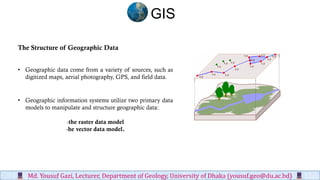
  • 1. The Structure of Geographic Data • Geographic data come from a variety of sources, such as digitized maps, aerial photography, GPS, and field data. • Geographic information systems utilize two primary data models to manipulate and structure geographic data: -the raster data model -he vector data model. GIS Md. Yousuf Gazi, Lecturer, Department of Geology, University of Dhaka (yousuf.geo@du.ac.bd)
  • 2. ❖ Raster data structures characterize continuous data (such as imagery). ❖ A raster image can vary in file format, color representation, resolution (size of pixels/ number of pixels per set area), and potential properties. ❖ Vector data structures characterize discrete data (such as roads, pipelines and topographic features) Vector Representation Raster Satellite Image Md. Yousuf Gazi, Lecturer, Department of Geology, University of Dhaka (yousuf.geo@du.ac.bd) GIS
  • 3. Advantages and Disadvantages of Raster and Vector Data ❑ Raster data, for example, offer a truly simple data structure that involves a grid of row and column data. This simple grid structure allows for easy raster image analysis, as well as analysis among multiple images. ❑ Disadvantages to raster data include general spatial inaccuracies and misrepresentations, low resolution, and massive data sets that require significant processing capability. GIS Md. Yousuf Gazi, Lecturer, Department of Geology, University of Dhaka (yousuf.geo@du.ac.bd)
  • 4. • Vector data, for instance, are spatially accurate and support a better, higher resolution than the raster data model. Advantages and Disadvantages of Raster and Vector Data • Due to the complex data structure, vector data require a greater and more powerful processing capability. GIS Md. Yousuf Gazi, Lecturer, Department of Geology, University of Dhaka (yousuf.geo@du.ac.bd)
  • 5. Vector Feature Geometry • Given the accurate, positional nature of vector data, features are best represented by coordinates and geometry. • Real-world objects can be represented as individual or a group of geometric shapes called feature geometries. • In any geospatial platform, there are three primary types of feature geometries: points, lines, and polygons. • As a subset of these three primary types there exists a fourth geometric feature called a polyline. GIS Md. Yousuf Gazi, Lecturer, Department of Geology, University of Dhaka (yousuf.geo@du.ac.bd)
  • 6. Raster Image Structures ➢ The nature of images, such as aerial photographs and base maps, involves a continuous array of data. ➢ A vector data representation of such an image produces a complex and often massive image structure. ➢ In brief, images are “rasterized” or digitally transformed to raster data through a matrix of pixels. Photographs are typically scanned with a set image resolution defined by pixels per inch (ppi), more commonly known as dots per inch (dpi). GIS Md. Yousuf Gazi, Lecturer, Department of Geology, University of Dhaka (yousuf.geo@du.ac.bd)
  • 7. ❖ The rule of thumb is: The more pixels in the grid, the higher the image resolution, quality, and dataset size; the fewer pixels in the grid area, the lower the image resolution, quality, and dataset size. ❖ Modifying the image’s resolution presents varying results within the image. ❖ It is easy to transform of a high resolution raster into a low resolution raster without desecrating image quality. However, it is not always easy to reverse this transformation. GIS Md. Yousuf Gazi, Lecturer, Department of Geology, University of Dhaka (yousuf.geo@du.ac.bd)
  • 8. Topology • Topology is the set of rules through which a GIS represents features with the primary geometric shapes (i.e., point, line, and polygon). • The vector data model utilizes topology to organize spatial relationships between discrete features. In essence, the main functions of topology are to define: (1) feature-to-feature locality or, simply, where a feature is in relation to another feature, (2) what is shared between different features, and (3) how features are grouped or connected within a set. In a GIS, topology establishes geometric harmony within a geographic data set. GIS Md. Yousuf Gazi, Lecturer, Department of Geology, University of Dhaka (yousuf.geo@du.ac.bd)
  • 9. ❑ Topological relationships are defined in all types of feature files and are generally categorized into the three primary functions of topology (previously mentioned): 1. Feature-to-feature locality, called a complement; 2. What different features share, called an intersection; 3. How features are grouped, called a union. GIS Md. Yousuf Gazi, Lecturer, Department of Geology, University of Dhaka (yousuf.geo@du.ac.bd)
  • 10. ✓ Topology also helps to avoid repeating feature data, such as shared boundaries and shared nodes (points). ✓ The data model stores a single line to represent a boundary, as opposed to two lines with the same coordinates. ✓ This topological quality control helps maintain a smaller data set and vector feature file. ✓ These geometric monitoring techniques allow GIS to control, query, and edit the topological coincidence between geospatial features (objects). ✓ Topology introduces the notion of absolute feature continuity, opening the door for numerous potential software compatibilities, including complex mathematics and engineering programs. GIS Md. Yousuf Gazi, Lecturer, Department of Geology, University of Dhaka (yousuf.geo@du.ac.bd)
  • 11. GIS Attribute Tables and Indices • Geospatial attribute tables, on the other hand, drive the spatially enabled database. There are various attribute field data types to handle the multitude of data, differentiated by a specific form of data and the degree of precision. • The following attribute field data types are most common and are supported in many major GIS environments: GIS Md. Yousuf Gazi, Lecturer, Department of Geology, University of Dhaka (yousuf.geo@du.ac.bd)
  • 12. Double. A more complex form of the Float attribute type with one sign bit, seven exponent bits, and 56 mantissa bits. As with the Long Integer, the Double attribute type holds greater precision than the Float attribute type. Text. Contains varying forms of data, such as numbers, letters, and symbols. The Text attribute type is a character string that can hold any amount of characters, but each character is stored using eight bits. Date. Though not apparent from the attribute data type name, a Date type contains date and time data. BLOB. Short for Binary Large Object. A BLOB is a complex (and large) object stored in the database that may include an image, sound, video, or geometry. GUID. Acronym for Globally Unique Identifier. A GUID is a unique 128-bit (16 byte) number that is produced to identify a particular application, file, database entry, hardware, or user. Short Integer. A basic attribute data type that includes one signed bit and 15 binary bits. Long Integer. A more complex form of the basic attribute type that incorporates one signed bit and 31 binary bits. As you can imagine, the Long Integer offers greater precision than the Short Integer. Float. Contains one signed bit, seven exponent bits, and 24 mantissa bits. GIS Md. Yousuf Gazi, Lecturer, Department of Geology, University of Dhaka (yousuf.geo@du.ac.bd)