
Recommended
Recommended
More Related Content
What's hot
What's hot (20)
Similar to Coastal Vulnerability Assessment Methods
Similar to Coastal Vulnerability Assessment Methods (20)
More from Md. Yousuf Gazi
More from Md. Yousuf Gazi (15)
Recently uploaded
Recently uploaded (20)
Coastal Vulnerability Assessment Methods
- 1. Coastal Vulnerability Md. Yousuf Gazi, Lecturer, Department of Geology, University of Dhaka (yousuf.geo@du.ac.bd)
- 2. • Risk Assessment • Local government interaction • Insurance industry involvement • Training on mitigation • Regional vulnerability atlas • Mitigation workshops • GIS as decision support tool Coastal Vulnerability Md. Yousuf Gazi, Lecturer, Department of Geology, University of Dhaka (yousuf.geo@du.ac.bd)
- 3. Coastal Hazard Mitigation • Multi-disciplinary efforts focusing on community risks and vulnerabilities and the true costs of hazards • Hazard Reduction – Altering the coastal environment (erosion control, beach nourishment) – Strengthening the built environment (wind proofing, elevating structures) • Hazard Avoidance Managing development in high hazard areas (land use planning, economic incentives, education) Prohibiting development in high hazard areas (zoning) Md. Yousuf Gazi, Lecturer, Department of Geology, University of Dhaka (yousuf.geo@du.ac.bd)
- 4. •Hazard Identification •Hazard Analysis •Critical Facilities Analysis •Societal Analysis •Economic Analysis •Environmental Analysis •Mitigation Opportunities Analysis ❑ Vulnerability Assessment Methodology Md. Yousuf Gazi, Lecturer, Department of Geology, University of Dhaka (yousuf.geo@du.ac.bd)
- 5. Hazard Identification: Storm Surge Wind Flood Tornado Earthquake Hazardous Spills Toxic Release Hazard Identification List of prioritized hazards for use in developing mitigation strategies and prioritizing mitigation projects. Input Output What hazards are you concerned about? How would you prioritize them? Md. Yousuf Gazi, Lecturer, Department of Geology, University of Dhaka (yousuf.geo@du.ac.bd)
- 6. • Data: Near-Real Time wave data (30 min-interval) transmitted to MMS used to validate forecasting models. • Period: 2012-2014 • End-users: fishermen venturing at sea Measuring Wave Energy Through Buoy: Md. Yousuf Gazi, Lecturer, Department of Geology, University of Dhaka (yousuf.geo@du.ac.bd)
- 7. Tsunami Warning System Through Buoy: Md. Yousuf Gazi, Lecturer, Department of Geology, University of Dhaka (yousuf.geo@du.ac.bd)
- 8. Communication Hardware PC Buoy Data Monitoring/Presentation Software Database Central Repository Communication Software Data Visualisation via Web-based Interface Configuration SoftwareSatellite/GSM/Radio Communication Receiving Station Md. Yousuf Gazi, Lecturer, Department of Geology, University of Dhaka (yousuf.geo@du.ac.bd)
- 9. Acquisition of satellite/aerial images Digitalize aerial photos Geo-reference and rectify images using GIS software Calculating shoreline change Shoreline Change: Determining the Coastal Vulnerability Index (CVI): Md. Yousuf Gazi, Lecturer, Department of Geology, University of Dhaka (yousuf.geo@du.ac.bd)
- 10. Service 2-2: Coastal Area Management Computation of Coastal Vulnerability Index Md. Yousuf Gazi, Lecturer, Department of Geology, University of Dhaka (yousuf.geo@du.ac.bd)
- 11. ▪ Determining the Coastal Vulnerability Index (CVI) (Sandwip Island) ▪ Satellite Imagery (Landsat) of study area during the year of (a) 1979, (b) 1989, (c) 1999, (d) 2004, (e) 2009, and (f) 2014. ▪ Location of the study area, the aerial extent of the present Sandwip Island has been taken from the recent satellite image (Landsat 8 OLI & TIRS) dated 11 December, 2014. Md. Yousuf Gazi, Lecturer, Department of Geology, University of Dhaka (yousuf.geo@du.ac.bd)
- 12. ▪ Displays vulnerable classes according to (a) Geomorphology; (b) Coastal slope; (c) Shoreline change rate; (d) Rate of sea level change; (e) Mean tide range; (f) Bathymetry. Md. Yousuf Gazi, Lecturer, Department of Geology, University of Dhaka (yousuf.geo@du.ac.bd)
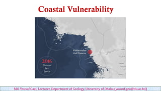
- 13. Eventual CVI Output: Md. Yousuf Gazi, Lecturer, Department of Geology, University of Dhaka (yousuf.geo@du.ac.bd)
- 14. ▪ The study area extends over thirteen districts of the coastal region and is located under three physiographic divisions namely, Tidal Delta, Active Delta and Inactive Delta. GALDIT: Determination of Salt water intrusion in GIS Environment ▪ Aquifer occurrence (type of aquifer) (G) ▪ Aquifer hydraulic conductivity (A) ▪ Height of groundwater level above sea level (L) ▪ Distance from the shore/high tide (D) ▪ Impact of Existing Status of Saltwater Intrusion (I) ▪ Aquifer thickness (T) Md. Yousuf Gazi, Lecturer, Department of Geology, University of Dhaka (yousuf.geo@du.ac.bd)
- 15. Methodology flow chart for GALDIT model: Md. Yousuf Gazi, Lecturer, Department of Geology, University of Dhaka (yousuf.geo@du.ac.bd)
- 16. ▪ Spatial distribution of aquifer type (G) for GALDIT model of the Ganges deltaic coast: (a) first aquifer (b) second aquifer and (c) third aquifer. Aquifer occurrence (type of aquifer) (G) Md. Yousuf Gazi, Lecturer, Department of Geology, University of Dhaka (yousuf.geo@du.ac.bd)
- 17. ▪ Spatial distribution of aquifer hydraulic conductivity (A) for GALDIT model of the Ganges deltaic coast: (a) first aquifer (b) second aquifer and (c) third aquifer. Aquifer hydraulic conductivity (A) Md. Yousuf Gazi, Lecturer, Department of Geology, University of Dhaka (yousuf.geo@du.ac.bd)
- 18. Height of groundwater level above sea level (L) ▪ Spatial distribution of water level (L) i.e., wet season for GALDIT model of the Ganges deltaic coast: (a) first aquifer (b) second aquifer and (c) third aquifer. Md. Yousuf Gazi, Lecturer, Department of Geology, University of Dhaka (yousuf.geo@du.ac.bd)
- 19. Distance from the shore/high tide (D) ▪ Spatial distribution of shoreline distance (D) for GALDIT model of the Ganges deltaic coast: (a) first aquifer (b) second aquifer and (c) third aquifer. Md. Yousuf Gazi, Lecturer, Department of Geology, University of Dhaka (yousuf.geo@du.ac.bd)
- 20. Impact of Existing Status of Saltwater Intrusion (I) ▪ Spatial distribution of sea water existence potential (L) i.e., wet season for GALDIT model of the Ganges deltaic coast: (a) first aquifer (b) second aquifer and (c) third aquifer. Md. Yousuf Gazi, Lecturer, Department of Geology, University of Dhaka (yousuf.geo@du.ac.bd)
- 21. Aquifer thickness (T) ▪ Spatial distribution of aquifer thickness (L) for GALDIT model of the Ganges deltaic coast: (a) first aquifer (b) second aquifer and (c) third aquifer. Md. Yousuf Gazi, Lecturer, Department of Geology, University of Dhaka (yousuf.geo@du.ac.bd)
- 22. ▪ Vulnerability map of wet season for the aquifer systems, (a) first aquifer (b) second aquifer and (c) third aquifer in the study area. Md. Yousuf Gazi, Lecturer, Department of Geology, University of Dhaka (yousuf.geo@du.ac.bd)
- 23. Md. Yousuf Gazi, Lecturer, Department of Geology, University of Dhaka (yousuf.geo@du.ac.bd)