
Recommended

Recommended
More Related Content
What's hot
What's hot (20)
Similar to Amelia Island
Similar to Amelia Island (20)
More from Arc Surveying & Mapping, Inc.
More from Arc Surveying & Mapping, Inc. (15)
Recently uploaded
Recently uploaded (20)
Amelia Island
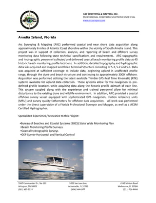
- 1. ARC SURVEYING & MAPPING, INC. PROFESSIONAL SURVEYING SOLUTIONS SINCE 1986 www.arcsurveyors.com 5567 Commander Dr., Ste 101 5202 San Juan Ave 4160 Minton Road Arlington, TN 38002 Jacksonville, FL 32210 Melbourne, FL 32904 (901) 867-5333 (904) 384-8377 (321) 728-8688 Amelia Island, Florida Arc Surveying & Mapping (ARC) performed coastal and near shore data acquisition along approximately 6 miles of Atlantic Coast shoreline within the vicinity of South Amelia Island. This project was in support of collection, analysis, and reporting of beach and offshore survey monitoring data following state technical specifications and requirements. ARC topographic and hydrographic personnel collected and delivered coastal beach monitoring profile data at 40 historic beach monitoring profile locations. In addition, detailed topography and hydrographic data was acquired and mapped and three Terminal Structure consisting of S-1, S-2 and S-3. Data was acquired at sufficient coverage to include data, beginning upland in unaffected profile range, through the dune and beach structure and continuing to approximately 3000’ offshore. Acquisition was performed utilizing the latest available Trimble GPS Real Time Kinematic (RTK) systems available for upland data collection. These systems allow for the navigation to pre- defined profile locations while acquiring data along the historic profile azimuth of each line. This system coupled along with the experience and trained personnel allow for minimal disturbance to the existing dune and wildlife environment. In addition, ARC provided a coastal offshore survey vessel equipped with sophisticated GPS navigation, motion reference units (MRU) and survey quality fathometers for offshore data acquisition. All work was performed under the direct supervision of a Florida Professional Surveyor and Mapper, as well as a ACSM Certified Hydrographer. Specialized Experience/Relevance to this Project: ▪Bureau of Beaches and Coastal Systems (BBCS) State Wide Monitoring Plan ▪Beach Monitoring Profile Surveys ▪Coastal Hydrographic Surveys ▪DEP Survey Horizontal and Vertical Control