
Recommended

Recommended
More Related Content
Viewers also liked
Similar to Streambank Erosion
Similar to Streambank Erosion (20)
More from Arc Surveying & Mapping, Inc.
More from Arc Surveying & Mapping, Inc. (9)
Recently uploaded
Recently uploaded (20)
Streambank Erosion
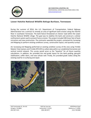
- 1. ARC SURVEYING & MAPPING, INC. PROFESSIONAL SURVEYING SOLUTIONS SINCE 1986 www.arcsurveyors.com 5567 Commander Dr., Ste 101 5202 San Juan Ave 4160 Minton Road Arlington, TN 38002 Jacksonville, FL 32210 Melbourne, FL 32904 (901) 867-5333 (904) 384-8377 (321) 728-8688 Lower Hatchie National Wildlife Refuge Burlison, Tennessee During the summer of 2014, the U.S. Department of Transportation, Federal Highway Administration let a contract to remedy an area of significant bank erosion along the Hatchie River in southwest Tennessee. The bank failure threatened an interior road within the Lower Hatchie National Wildlife refuge. The goal was to stabilize the bank and construct a cellular confinement system wall to prevent future erosion. The project included 500 linear feet of bank correction and new construction. The contractor awarded the project, contacted Arc Surveying and Mapping to perform existing conditions survey, construction layout, and quantity surveys. Arc Surveying and Mapping performed an existing condition survey of the area using Trimble Robotic Total stations and Trimble RTK GPS to collect data within our established horizontal and vertical control network. This survey would serve as the “baseline” for all future quantity calculations. In addition, Arc provided line and grade layout for the bank grading, geo-grid stabilization, coffer dams, and new cellular wall. Finally, Arc provided grade stakes along the existing road for re-surfacing and repair.