Professional Surveyors Map Lake Okeechobee for Dike Project
•
0 likes•105 views

Arc Surveying & Mapping was tasked by the Jacksonville District Corp of Engineers to acquire multibeam hydrographic data of over 25 square miles of Lake Okeechobee along 22 miles of shoreline. Arc employed a Reson Corporation 7101 Multibeam sonar system, Coda F-180 IMU, and Trimble RTK GPS to map the lake bottom. The data was collected and processed using HYPACK and HYSWEEP software. The results provided a baseline data set to analyze changes from future surveys assessing the rehabilitation of the Herbert Hoover Dike within Lake Okeechobee.

Recommended
More Related Content
Similar to Professional Surveyors Map Lake Okeechobee for Dike Project
Similar to Professional Surveyors Map Lake Okeechobee for Dike Project (20)
More from Arc Surveying & Mapping, Inc.
More from Arc Surveying & Mapping, Inc. (18)
Recently uploaded
Recently uploaded (20)
Professional Surveyors Map Lake Okeechobee for Dike Project
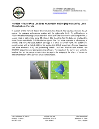
- 1. ARC SURVEYING & MAPPING, INC. PROFESSIONAL SURVEYING SOLUTIONS SINCE 1986 www.arcsurveyors.com 5567 Commander Dr., Ste 101 5202 San Juan Ave 4160 Minton Road Arlington, TN 38002 Jacksonville, FL 32210 Melbourne, FL 32904 (901) 867-5333 (904) 384-8377 (321) 728-8688 Herbert Hoover Dike Lakeside Multibeam Hydrographic Survey Lake Okeechobee, Florida In support of the Herbert Hoover Dike Rehabilitation Project, Arc was tasked under its A/E contract for surveying and mapping services with the Jacksonville District Corp of Engineers to acquire Multibeam Hydrographic data within Reach 1 of Lake Okeechobee consisting of over 25 square miles of bathymetry along 22 miles of dike shoreline. For this task, Arc employed its Reson Corporation Model 7101 Multibeam system. The 7101 sonar operates at a frequency of 240 kHz and allows for 100% bottom coverage at 7 times the water depth. The system was complimented with a Coda F-180 Inertial Motion Unit (IMU), as well as a Trimble Navigation Real Time Kinematic (RTK) GPS positioning system. Data was acquired with HYPACK and HYSWEEP acquisition and post processing software. The results of the survey was utilized a baseline data set for comparisons to future surveys in the analysis of the effects of the recent dike rehabilitation within portions of Lake Okeechobee.