
Recommended
Recommended
More Related Content
What's hot
What's hot (20)
Similar to urban studies NASHIK by GB
Similar to urban studies NASHIK by GB (20)
Recently uploaded
Recently uploaded (20)
urban studies NASHIK by GB
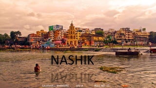
- 1. NASHIK GAJANAN J. BHAMARE DIV-A ROLL NO- 11
- 2. The entire Nashik district is underlain by the basaltic lava flows. These flows are normally horizontally disposed over a wide stretch and give rise to table land type of topography also known a plateau TOPOGRAPHY Nashik is an ancient holy city in the northern region of the Indian state of Maharashtra. Situated on the banks of river Godavari, Nasik is well known for being one of Hindu pilgrimage sites, that of Kumbh Mela which is held every 12 years. It is the fourth largest city in Maharashtra after Mumbai, Pune and Nagpur. The city located about 190 km north of state capital Mumbai, is called the "Wine Capital of India" as half of India’s vineyards and wineries are located in Nashik. ETYMOLOGY As per Ramayana, Nashik is the location on the banks of Godavari river where Laxman, by the wish of Lord Rama, cut the nose of Shurpanakha and thus this city was named as "Nashik".
- 3. SOIL TYPE IN NASHIK REGION • Although soil has a profound effect on agriculture it is a derived factor of rocks, climate, vegetation and time together. Soil • is the fundamental medium for crops. It acts as a bond or link between biotic and a biotic components. Soil has certain physical chemical and. • In order to make efficient landuse as soil provides basic nutrients to plants for longer than chemical fertilizers. The forest in distric falls into three different types 1) Deciduous forest tending towards monster type, found in western and north-western parts of the district. 2) The Evergreen type forest observed along the terraces of the Western Ghats and 3) The Dry deciduous forest . The total forest area in the district is 928.9 square km. situated below the ghat region. The remaining forest cover observed on the ghat tract with three distinct ranges of hills running in an easterly direction. These three ranges of hills are intensively cultivated and populous basin of the Girna and the Godavari rivers VEGETATION
- 4. STATISTICAL DATA POPULATION GROWTH RATE DIVISEX RATIO LITERACY
- 6. LAND USE MAP Nashik is the third-largest city in Maharashtra and one of the fastest growing cities in India.
- 7. LAND USE MAP Objectives of Nashik Master Plan 2036 • To ensure proper utilization of the land and to guide the future development in disciplined and orderly manner • Plan and provide the most efficient traffic-transportation network so as to improve connectivity • To make the provision for social and physical infrastructure by minimizing the personal inequality • To make provisions in the DP and DCPR to create more housing stock in the market and try to bring it within the reach of common man. • Make provisions for redevelopment for slums, The vision of Nashik Master Plan 2036 is as follows: “To achieve planned, comprehensive, participative, stakeholder friendly, rational, sustainable and growth driven development of Nashik City and make citizen oriented policies, so that Nashik city should emerge as an orderly developed city on the map of India.” EXISTING PROPOSED SOURCE: Nashik Master Plan 2036
- 8. HISTORICAL EVOLUTION MUNCIPAL LIMITS HISTORICAL TRANSFORMATION
- 9. GROWTH RATE IN LAST 40-50 YEARS POPULATION DENSITY ACCORDING TO SECTORS DIVISION Nashik’s Population Projection
- 10. • The population of Nashik is expected to grow from 1.08 million to 1.75, 2.6 and 3.75 million by 2011, 2021 & 2031 respectively. • Notably there are variations in population projections in various studies and DPRs. This variation in population projection has serious implications for future planning. • The population of Nashik city grew from 0.15 millions in 1951 to 1.49 million in 2011 GROWTH & PRESENTPOPULATION
- 11. CITY GOVERNANACE Government • Type Municipal Corporation • Mayor Satish Kulkarni • Guardian Minister Chhagan Bhujbal • Municipal Commissioner Radhakrishna Game • Commissioner of Police Vishwas Nangare Patil
- 12. HEALTH AND EDUCATION • There are in all 352 primary schools with total number of 1,53,644 students and 154 high school with total number of 1,17,381 students in the corporation area. • Also there are numberous of colleges for higher education
- 13. • The hospitals are mainly concentrated around main road, market yard and panchavati. The sector no. I and ii have low concentration of hospitals because this is unavailable land area and have lower population concentration • There are 4 hospitals which are run by the Government, having total capacity of 750 beds. in total and 20 dispensaries. • There are 293 private or public trust hospitals with total 6507 beds capacity, 59 maternity homes with 615 beds capacity and 775 dispensaries. HEALTH AND EDUCATION SOME OF THE MAJOR INSTITUTES IN NASHIK
- 14. RECREATIONAL AREA • The commercial facilities such as agricultural produce market committee yard, whole sale / retail grain markets, vegetable markets, mutton markets, ghass markets exist in the developed part of the corporation area. • There are other commercial establishments like, shopping mall, departmental store company showrooms etc, and so many retail shops. • There are in all 144 gardens and 32 playgrounds in the city having total area of 98.87 hectares and 64.21 hectares respectively. COMMERCIAL FACILITIES
- 15. Language: • The primary language spoken in Nashik is Marathi. It is the native language of the city and state, and originates from Sanskrit. • English and Hindi are also widely spoken by the population. SOCIO- CULTURAL ASPECTS CULTURE AND FESTIVAL • Rath Yatra is major attraction of the festival called Janmotsav which is celebrated at Sansthan Shri Kalaram Mandir of Panchvati in which two raths Shri Ram and Garuda Raths travels through the Nashik city. • Kumbh mela is largest , sacred and most important Hindu spriitual gathering in Trimbakeshwar. • Nashik being a major producer of wine is a renowed tourist destination of wine tourism. • Sula fest is held in Sula Vineyards. • Ganesh Chaturthi also known as Vinayak Chaturthi is one of the most important, electrifying enthusiasm Hindu festival. • Dasara is celebrated as the victory of Lord Rama over Demon Lord Ravana and alspo as the triumph of Goddess Durga over the buffalo Demon Mahishasura. The festival is also known as Vijayadashmi or Dussehra. Festivals
- 16. • THE INDUSTRIES ARE MAINLY CONCENTRATED IN MIDC, SATPUR, AMBAD, CIDCO AREA THE PRESENT INDUSTRIES IN THE MIDC AREA ARE PHARMACEUTICALS, CHEMICAL, ENGINEERING AND OTHERS • DAL MILLS, OIL MILLS INDUSTRIES BASED ON FRUITS AND VEGETABLES GINNING AND PRESSING • NASHIK IS LARGEST PRODUCER OF GRAPES, POMEGRANATES, TOMETOES AND ONIONS IN INDIA
- 17. INDUSTRY AND WORKFORCE AGRICULTURE • Nashik valley wines are specially protected under the patent of the geographical indicator in india for the region of nashik district in maharashtra, india, where it is produced from several vineyards and the sula wine is one of the major producer of wines in nashik. • The wine is produced in two types: red and white. • The district has 29 wineries in operation and consequently nashik is occasionally known by the epithet "the wine capital of india“. • Nashik had been growing very fast industrially, during the last few decades. • There are some major industrial activities on the out skirt of Nashik city, such as Hindustan Aeronautics Ltd. at Ozar, Thermal power station at Eklahare, Sinnar M.I.D.C
- 18. HERITAGE Trimbakeshwar Temple • Trimbakeshwar is an ancient Hindu temple in the town of Trimbak near Nashik. • It is areligious center having one of the twelve Jyotirlingas. Pandav Leni Caves • The caves, also known as Trirashmi Buddhist Caves • The group of 24 caves was cut in a long line on the north face of a hill called Trirasmi. Anjneri Fort • Anjaneri is the birthplace of Hanuman, and is named after Hanuman's mother, Anjani. • 108 Jain caves are found here belonging to 12th century. Tranquil Ghats • Ghats form an integral part of Godavari riverbank. • Ahilya Devi Holkar constructed them to facilitate the religious rituals. Trimbakeshwar temple, around 30 kilometers west of nashik, is particularly revered and popular with pilgrims.. Most of the action of the nashik kumbh mela happens in the vicinity of temple. Hiking, brahmagiri hill is worth the climb. The source of the holy godavari river is in the brahmagiri range. Victoria bridge is one of the oldest bridge in nashik constructed in 18th centuri which connects upper and lower part of heritage in nashik In the heart of nashik's old city, ramkund ghat attracts both pilgrims and tourists to its holy waters. Lord ram bathed and performed the death rituals of his father there. Ramkund Brahmagiri Trimbak Victori bridge
- 19. HOUSING HISTORICAL WADAS MARKET CENTRE Due to increasing population in nashik as well as industry community housing is the need that’s why many open plots are adopted by builders for future housing development as per mastered plan 2036.
- 20. TRAFFIC AND TRANSPORTATION AIR • The nearest one is at Ozar Airport (domestic military) which is located about 24km from the city center. RAIL • The Nashik Road Railway Station is located about 10 kms from Nashik city. ROAD • The existing road pattern of the Nashik Corporation Area is almost radial one. The National Highway No.3, Mumbai-Agra Road passes through the Nashik city, while National Highway No.50 i.e. Pune - Nashik Road meets Mumbai-Agra Road in the central part of the city near Dwarka point. TRAFFIC&TRANSPORTATION • TrafficandTransportationuse comprisesof roads,railwaylines andstation, truck terminus, bus terminus, bridges and flyovers, airport andparking lots/area existingin thecity. • the total area under this useis1388.67 hectares which is16.66percent of the total developedareaand9.75 percent of the total municipal areaof thecity. • Theexistingareaunder this category islessthan the prescribed norm of 15 to18 percent for the metrocities.
- 21. ENVIRONMENT • Nashik has a mild climate for most of the year from March to Mid June. • The City has a Semi-Arid climate. • The city Experiences a Mid-Winter from Nov. to Feb,with warm & cool nights • although • cold waves can Dip temp. Max. temp = 44.8⁰ C • Hottest Month May (30 °C avg) • Coldest Month January (24 °C avg) • Wettest Month July (386.7 mm avg) • Windiest Month July (16 km/h avg) • Annual Rainfall 1191.0 mm (per year)
- 22. SERVICES SEWAGE DISPOSAL PLAN • Wards 1, 2, 8, 10, 11, 12 and 13 continue disposing the sewage through open drains • The highest proportion of sewage (30%) being let into open drains is from Ward 10 Wards disposing 60%or more than 60%of sewage through sewer line Wards disposing more than 40%of sewage through septic tanks Wards disposing sewage through Open Drain Source – Sanitory Nashik.pdf Distribution of Toilet Facility Access To Toilets - Urban Poor
- 23. 120% 100% 80% 60% 40% 20% 0% -20% 1 3 5 7 9 11 13 15 17 19 21 23 25 27 29 31 33 35 37 39 41 43 45 47 49 51 53 55 57 59 61 63 65 67 69 71 73 75 77 79 81 83 85 87 89 91 93 95 97 99 101 103 105 107 Toilets in house Open Defecation Community Toilet Complexes Common for 2 or morehouses SERVICES AND OPEN DEFECATION AREA IN NASHIK WARDS Open-defecation-prone areas in the city SERVICES
- 24. NATURAL DRAINAGE NETWORK IN NASHIK CIDCO DIVISION 3 1 7 2 6 4 5 21 25 8 23 PANCHAWATI DIVISION 9 13 12 11 10 24 51 22 26 20 19 18 17 16 27 14 28 50 NASHIK WEST DIVISION45 48 46 47 15 29 44 30 49 59 52 60 31 58 62 40 6357 SATPUR DIVISION 54 53 55 81 56 32 82 78 33 79 64 39 87 NASHIK EAST65 DIVISION 80 37 34 88 36 35 77 89 86 38 90 68 76 6984 104 85 103 105 92 91 106 67 93 102 73107 75 108 NASHIKR72 OAD DIVISION 71 74 70 100 101 94 97 95 96 99 98 WALDEVI RIVER WALDEVI RIVER GODAVARI RIVER 43 42 GODAVARI RIVER 41 61 GODAVARI RIVER NASARDI RIVER NASARDI RIVER NASARDI RIVER 83 DARNA RIVER Devlali C6 a6 ntonment Area MILITARY AREA MILITARY AREA Covered Open Underground PartialCovered No Gutters 19 1311 21 1 Figure : Slums with various types of gutters NMC Groundwate r 0.2 % 98.3 % 0.1 % 1.4 % Pvt Tanker Other Source of WaterSupply Water supply in slums No.ofSlumshaving handpumps No.ofslumshaving public stand post No.ofslumswithout any individual connections No.ofslumshaving 100% individual connections. . 9 1 0 1 6 5 7 NASHIK SLUM
- 25. IDENTIFICATION OF PROBLEM AND SOLUTION • Nashik city has got a great importance through heritage structures but due to modern era this structures are getting affected that should be controlled under gov dept. • Historical incidents also have shaped the social, economical and physical aspects of Nashik. • It is observed that total lang reserved for various purpose in sanctioned DP is 692.44H. It means that only 22% of the land could be acquired under various tools available for acquisition of reserved sites. • Slum population in the Nashik city is remarkable. These slum dwellers need to be provided proper accomodation and amenities. • The residential and other develpoment is taking place all over the city. • There is inadequate and un-coordinated traffic transportation network. • Other than Mumbai-Agra highway flyover there is necessity of other bypass road to link National and State highway. • Public parling is required at the place like C.B.S., M.G. Road, Main road, Canada corner, College Road, Gangapur Road, Dwarka Junction, Bytco Point etc. • While making Nashik a Smart City government should make sure that the natural and historical heritage should not be affected. • Slums area should get developed under smart city project. • Certain facilities should get provided for increasing population in nashik .
- 26. SOURCE • Draft Master Plan Nashik 2011–2036.pdf • Sanitory in Nashik.pdf • Adsem6final.pdf • 08_Chapter-02.pdf • www.Google.com. • Nashik district- Wikipedia. • https://www.researchgate.in/Nashikcity.pdf. • Slide share- Nashik as a city with cultural asthetics