The Street Tree Effect and Driver Safety
`
For more information, Please see websites below:
`
Organic Edible Schoolyards & Gardening with Children
http://scribd.com/doc/239851214
`
Double Food Production from your School Garden with Organic Tech
http://scribd.com/doc/239851079
`
Free School Gardening Art Posters
http://scribd.com/doc/239851159`
`
Increase Food Production with Companion Planting in your School Garden
http://scribd.com/doc/239851159
`
Healthy Foods Dramatically Improves Student Academic Success
http://scribd.com/doc/239851348
`
City Chickens for your Organic School Garden
http://scribd.com/doc/239850440
`
Simple Square Foot Gardening for Schools - Teacher Guide
http://scribd.com/doc/239851110
StreetSeen: Factors Influencing the Desirability of a Street for BicyclingJennifer Evans-Cowley
In what is one of the first visual preference surveys using Google Street View through a free tool StreetSeen (http://streetseen.osu.edu), adult students viewed a series of paired slides of image of city streets. Participants were asked to choose which image from the pair they preferred based on which street they would prefer to ride a bicycle. Subsequent analyses showed that differences in continent of the respondent impact preferences. This research demonstrates the extent to which certain segment-level factors such as presence of trees along the street, width of the street, presence of sidewalks, and other features are preferred using discrete choice models. The models reveal that increasing vehicle traffic, number of lanes, streetscapes with dense trees, and presence of parking lots decrease the probability of being chosen. Having sidewalks, presence of pedestrians, trees set back from the street, and traffic calming devices are positively associated with respondents’ preferences. The results related to trees may relate to perceptions of safety. For example, dense trees close to a street may limit visibility along a roadway. The models also reveal significant differences in preferences based on respondents’ locations. We conclude that this method is effective in capturing information about bicycling preferences. The survey methodology and analysis techniques introduced in this study can help city planners design streets that are preferred by bicyclists.
Commuters’ Perception of Legibility and Complexity with Respect to Path Choic...drboon
The effect of environmental factors on walking behavior needs to be considered based on the purpose of walking trip; whether walking for transport or walking for recreational purposes. Since everybody walks on his/her daily transport, studying walking behavior of those who walk for transport would contribute to maintain the minimum rate of physical activity. Commuters are the major group of those who walk for transport. It was found that the path choice of pedestrians can be considered to examine the effects of environmental factors on walking behavior. Introducing two environmental factors of perceived legibility and perceived complexity, it is demonstrated that the theoretical and empirical relationship between these factors and walking behavior as well as the path choice criteria, leads to define these two factors in accordance with commuter’s specifications. Accordingly, both perceived legibility and perceived complexity are two important path choice criteria of commuters in CBD of Kuala Lumpur.
Although the street was once a multi-use space, the rise of vehicles has resulted in the street being regarded as a place for motorists with the primary purpose of moving vehicles quickly. Home zone represents an opportunity to restore the role of streets as a shared space to be used by pedestrians and cyclists as well as motorists with the privilege of pedestrians over the other road users. The most important aim of a Home Zone is to improve the quality of life in residential streets by making them
places for people not for vehicles. Research conducted on residents’ feelings about their neighbourhoods before and after implementing Home Zone show, if principles of Home Zone design are fully implemented, Home Zones can be safe, secure, pleasant, and attractive areas which not only decrease through traffic and vehicles’ speed but also improve social interactions and residents’ quality of life.
Kittelson's Brian Ray and special guest Dr. John M. Mason, PhD presented this topic at a workshop on 4/15/10. It focused on how industry trends in performance based design can support practical design-based project solutions. Brian and John provided a summary of current and emerging tools that can aid professionals in evaluating, screening, and selecting project alternative concepts. For more information contact Brian 800-878-5230.
This is a presentation for use in Japan on the context of the Crop Trust in the international realm as well as the Japanese national system in context with the international system on the conservation and use of crop diversity.
Get the details about diwali diya manufacturers and suppliers with there complete details. We have a large list of manufacturers and exporters from india.
10 Productivity Tips From Hootsuite & EvernoteHootsuite
As a social media marketer, you are constantly on the lookout for new tools that can make you more productive online! Today’s smart businesses know that time is of the essence and improving your social media engagement can feel like a never ending task—but it doesn’t have to.
Our experts at Hootsuite and Evernote are constantly making sure there is an easier way to work smarter online!
Watch the webinar here:
https://www.youtube.com/watch?v=FSSRqAijkOM
Sign up today for a free 30 day trial and receive custom training from our team of product experts! https://hootsuite.com/plans/pro
Pedestrian Conflict Risk Model at Unsignalized Locations on a Community Streetcoreconferences
Crossing a street at unsignalized location can be dangerous to pedestrians, especially the elderly. This paper evaluate the pedestrianvehicle collision risk on specific roads to identify that the degree of Pedestrian safety requires pedestrian intervention such as road improvement. First, age was a significant variable in that older people tend to be at greater risk than the non-elder people. There was an insignificant difference between the PSM of approaching vehicles that were traveling at speeds less than 30 km/h and those traveling at speeds in the range of 30-50 km/h. Interestingly, conflicts when the speed of the vehicles exceeded 50 km/h, the risk of conflict risk was higher than it was for vehicles traveling at speeds below 30km/h. The ratio of conflict risk for crossing gradient topography road was about 21.7 times greater than that for the non-gradient topography area. Regarding safety facilities, the 30 km/h speed limit sign influenced the risk situation of conflict. The ratio of conflict risk for a road with the safety facility was about 0.395 times lower than that for an unmarked road.
International Refereed Journal of Engineering and Science (IRJES)irjes
The core of the vision IRJES is to disseminate new knowledge and technology for the benefit of all, ranging from academic research and professional communities to industry professionals in a range of topics in computer science and engineering. It also provides a place for high-caliber researchers, practitioners and PhD students to present ongoing research and development in these areas.
Awareness on Road Signs and Markings of Drivers and Passengers along Maharlik...IJAEMSJORNAL
Road signs and markings are an integral part of the transportation systems which are logically designed and employed to provide essential road information for commuters’ safety and protection. The study is an evaluation of drivers and passengers’ awareness regarding road signs and markings along Maharlika Highway in the Province of Nueva Ecija particularly between the cities of San Jose and Cabanatuan. While drivers understanding and perception of road signs and markings were very substantial in the study, the perceptions of common passengers wereadded, because they are generally the victims of road accidents. A total of 100 drivers and passengers from the locality were surveyed based on a 4-point Likert scale ranging from strongly disagree (1) to strongly agree (4). The findings showed thatdrivers were aware and knowledgeable about road signs and markings but did not strictly abide by it. Passengers, on the other hand, were not very much aware of road safety features like road signs and markings and relied heavily on the capability of drivers since they believe that drivers were following rules and regulations onroad signs and markings.
Analyzing the indicators walkability of cities, in order to improving urban v...IJMER
Urban design is a technique and knowledge seeking to organize and improve urban qualities
and increase the quality of citizenship life. Based on the perspectives and objectives of urban design, the
dominant intention in all urbanism activities is to reach high humanistic and social dimensions. In fact,
what give meaning to a city are the social aspects raised in recent urban activities, in addition to the
physical and visual body of it. Over the past decade the quality of the walking environment has become
a significant factor in transportation planning and design in developed countries. It is argued that the
pedestrians’ environment has been ignored in favors of automobile. The purpose of this study was to
examine the effects of walkability on property values and investment returns. Research method is
descriptive. The method of collected data is field. Also, were used questionnaire tools in order to
collecting data. On the other hand, was referred to municipality 9 region due to, studied area was
located in this urban region.
In continue, was used SWOT technique in order to analyzing questionnaire. At finally, proposed
strategies in order to improving urban space qualify.
Analyzing the indicators walkability of cities, in order to improving urban ...IJMER
Urban design is a technique and knowledge seeking to organize and improve urban qualities and increase the quality of citizenship life. Based on the perspectives and objectives of urban design, the dominant intention in all urbanism activities is to reach high humanistic and social dimensions. In fact, what give meaning to a city are the social aspects raised in recent urban activities, in addition to the physical and visual body of it. Over the past decade the quality of the walking environment has become
a significant factor in transportation planning and design in developed countries. It is argued that the pedestrians’ environment has been ignored in favors of automobile. The purpose of this study was to examine the effects of walkability on property values and investment returns. Research method is descriptive. The method of collected data is field. Also, were used questionnaire tools in order to
collecting data. On the other hand, was referred to municipality 9 region due to, studied area was located in this urban region. In continue, was used SWOT technique in order to analyzing questionnaire. At finally, proposed
strategies in order to improving urban space qualif
A B S T R A C T
The study aimed to answer the question of how pedestrianisation can influence walkability to increasing physical activity vitality and livability of urban spaces. Therefore, after the theoretical understanding of the framework of the research, the study will focus on experimental research on the Salamis rode of Famagusta to assess the problems of walkability in the street to propose a sustainable and human friendly solution for this area. The main aim of the research is to find what is the interrelation between pedestrianisation in public urban spaces and walkability? Therefore, it concludes that walkability as a part of pedestrianisation scheme will lead to increase the quality of the urban environment by increasing safety and organization in urban infra-instructors.
CONTEMPORARY URBAN AFFAIRS (2018) 2(1), 102-112. Doi: 10.25034/ijcua.2018.3666
www.ijcua.com
Evaluation of Pedestrian Safety and Road Crossing Behavior at Midblock Crosswalkshrikrishna kesharwani
This report is made by shrikrishna kesharwani
student of M.Tech, 1st year transportation engineering
NIT WARANGAL,
FOR MORE INFORMATION CONTACT ME THROUGH INSTAGRAM
FOLLOW ME ON INSTAGRAM - @SHRIKRISHNAKESHARWANI
Similar to The Street Tree Effect and Driver Safety (20)
We all have good and bad thoughts from time to time and situation to situation. We are bombarded daily with spiraling thoughts(both negative and positive) creating all-consuming feel , making us difficult to manage with associated suffering. Good thoughts are like our Mob Signal (Positive thought) amidst noise(negative thought) in the atmosphere. Negative thoughts like noise outweigh positive thoughts. These thoughts often create unwanted confusion, trouble, stress and frustration in our mind as well as chaos in our physical world. Negative thoughts are also known as “distorted thinking”.
Read| The latest issue of The Challenger is here! We are thrilled to announce that our school paper has qualified for the NATIONAL SCHOOLS PRESS CONFERENCE (NSPC) 2024. Thank you for your unwavering support and trust. Dive into the stories that made us stand out!
Palestine last event orientationfvgnh .pptxRaedMohamed3
An EFL lesson about the current events in Palestine. It is intended to be for intermediate students who wish to increase their listening skills through a short lesson in power point.
How to Make a Field invisible in Odoo 17Celine George
It is possible to hide or invisible some fields in odoo. Commonly using “invisible” attribute in the field definition to invisible the fields. This slide will show how to make a field invisible in odoo 17.
The Roman Empire A Historical Colossus.pdfkaushalkr1407
The Roman Empire, a vast and enduring power, stands as one of history's most remarkable civilizations, leaving an indelible imprint on the world. It emerged from the Roman Republic, transitioning into an imperial powerhouse under the leadership of Augustus Caesar in 27 BCE. This transformation marked the beginning of an era defined by unprecedented territorial expansion, architectural marvels, and profound cultural influence.
The empire's roots lie in the city of Rome, founded, according to legend, by Romulus in 753 BCE. Over centuries, Rome evolved from a small settlement to a formidable republic, characterized by a complex political system with elected officials and checks on power. However, internal strife, class conflicts, and military ambitions paved the way for the end of the Republic. Julius Caesar’s dictatorship and subsequent assassination in 44 BCE created a power vacuum, leading to a civil war. Octavian, later Augustus, emerged victorious, heralding the Roman Empire’s birth.
Under Augustus, the empire experienced the Pax Romana, a 200-year period of relative peace and stability. Augustus reformed the military, established efficient administrative systems, and initiated grand construction projects. The empire's borders expanded, encompassing territories from Britain to Egypt and from Spain to the Euphrates. Roman legions, renowned for their discipline and engineering prowess, secured and maintained these vast territories, building roads, fortifications, and cities that facilitated control and integration.
The Roman Empire’s society was hierarchical, with a rigid class system. At the top were the patricians, wealthy elites who held significant political power. Below them were the plebeians, free citizens with limited political influence, and the vast numbers of slaves who formed the backbone of the economy. The family unit was central, governed by the paterfamilias, the male head who held absolute authority.
Culturally, the Romans were eclectic, absorbing and adapting elements from the civilizations they encountered, particularly the Greeks. Roman art, literature, and philosophy reflected this synthesis, creating a rich cultural tapestry. Latin, the Roman language, became the lingua franca of the Western world, influencing numerous modern languages.
Roman architecture and engineering achievements were monumental. They perfected the arch, vault, and dome, constructing enduring structures like the Colosseum, Pantheon, and aqueducts. These engineering marvels not only showcased Roman ingenuity but also served practical purposes, from public entertainment to water supply.
2024.06.01 Introducing a competency framework for languag learning materials ...Sandy Millin
http://sandymillin.wordpress.com/iateflwebinar2024
Published classroom materials form the basis of syllabuses, drive teacher professional development, and have a potentially huge influence on learners, teachers and education systems. All teachers also create their own materials, whether a few sentences on a blackboard, a highly-structured fully-realised online course, or anything in between. Despite this, the knowledge and skills needed to create effective language learning materials are rarely part of teacher training, and are mostly learnt by trial and error.
Knowledge and skills frameworks, generally called competency frameworks, for ELT teachers, trainers and managers have existed for a few years now. However, until I created one for my MA dissertation, there wasn’t one drawing together what we need to know and do to be able to effectively produce language learning materials.
This webinar will introduce you to my framework, highlighting the key competencies I identified from my research. It will also show how anybody involved in language teaching (any language, not just English!), teacher training, managing schools or developing language learning materials can benefit from using the framework.
Ethnobotany and Ethnopharmacology:
Ethnobotany in herbal drug evaluation,
Impact of Ethnobotany in traditional medicine,
New development in herbals,
Bio-prospecting tools for drug discovery,
Role of Ethnopharmacology in drug evaluation,
Reverse Pharmacology.
How to Split Bills in the Odoo 17 POS ModuleCeline George
Bills have a main role in point of sale procedure. It will help to track sales, handling payments and giving receipts to customers. Bill splitting also has an important role in POS. For example, If some friends come together for dinner and if they want to divide the bill then it is possible by POS bill splitting. This slide will show how to split bills in odoo 17 POS.
1. ITE Journal on the web / February 2008 69
By JODY ROSENBLATT NADERI, BYOUNG SUK KWEON, Ph.D. AND PRAVEEN MAGHELAL
This pilot presents empirical findings on street trees and their effect on driving behavior, safety perception and speed. The experiment investigated the effect of trees on perception of safety and driving speeds in urban or suburban settings. Tree-lined streets were perceived to be safer in both urban and suburban conditions. Individual driving speeds were significantly reduced in the suburban settings with trees.
The Street Tree Effect and Driver Safety
INTRODUCTION
Street trees are dangerous, difficult to install and expensive to maintain, but there is not a transportation engineer who has not had to negotiate tree planting or tree preservation to reach project completion. Engineering design and transportation planning guidelines consider street trees obstacles in the roadside environment. Transportation research related to street trees in the United States focuses on fatal off-road crashes. Although much of this research is highway focused, it impacts the roadside environment of arterials and collectors as well.
Although there is an historical aversion to invest in the installation and maintenance of street trees from an operational perspective, the multimodal traveling public loves them. U.S. National Cooperative Highway Research Program Project 17- 18(3) summarizes the street tree issue facing transportation engineers: “A complicating factor in addressing fatal tree crashes is the widespread interest and indeed promotion of tree-planting and preservation associated with highways.” 1 This is even more true with the local network.
In the United States, the “no trees” guidelines are housed primarily with the American Association of State Highway and Transportation Officials and reiterated in municipal manuals and standards.2 The objective is to improve road safety by prohibiting obstacles that drivers running off the road might encounter during a crash event, reducing the severity of the event. The only roadside features permitted in the clear zone are ones that contribute positively to the safe performance of drivers and/or road operations. Recent research into the effect of street trees calls for re- examining these standards as they pertain to streetscape, suggesting that the aesthetic effect may provide safety benefits to road operation, safety and pedestrian use.3,4
Links between pedestrian modalities and physical activity underscore the importance of roadside environment to public health.5 The public participation and project review process in North America has evolved recently to produce the Institute of Transportation Engineers’ (ITE) Context Sensitive Solutions in Designing Major Urban Thoroughfares for Walkable Communities: An ITE Recommended Practice and the Federal Highway Administration’s Flexibility in Highway Design.6,7 In Europe, transportation psychologists are challenging the premise suggesting safer behavior is generated by altering the landscape to include streetscape treatments.
Researchers Dumbaugh, Topp, Rosenblatt and Bronfman-Bahar and Mok revealed that streetscape had a positive effect on reducing the frequency and severity of crashes.8–11 These streetscape improvements, which included street trees, were installed in response to environmental mitigation or economic development pressure. The safety effect measured in these studies was incidental or coincidental and not an original intention.
Design standards that incorporate the safety benefit of street trees on drivers and other users of the roadway must be performance-based and tested. This pilot study sought a proof of concept that there is a positive street tree effect on safer driver behavior.
THEORETICAL FRAMEWORK
The fields of experimental psychology and urban design suggested a respected paradigm to explore the effect of roadside landscape on behavior. The measure developed for use in simulation was derived from Berlyne’s theory of visual complexity in the field of environmental psychology and Lynch’s work in the aesthetic dimensions of city legibility. Findings from these seminal authors were used to develop a framework for the inquiry.
Street trees can be visually understood by
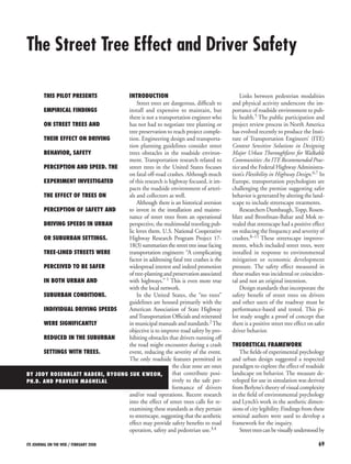
2. 70 ITE Journal on the web / February 2008
measuring their color, texture, line and form throughout the seasons. Driver perception is manipulated by the edge of the visual environment affecting the scale, proportion and rhythm of the driving experience. Berlyne observed how different levels of visual complexity affect attention and alertness.12
When “on alert,” movements through space tend to be more careful. The street tree may be defining the edge of space by providing a diverse visual edge that also is repetitively simple in color, texture and form. According to Berlyne, optimum levels of complexity that maximize attentiveness fall within this mean: a visual landscape that is diverse but not overwhelmingly so; simple but not to the point of boring.
According to Lynch, spatial edge acts as a structural reference allowing people to find their way and feel “at home.”13 The tree-lined street may present an edge to the driver between the travel way and the contextual environment. Lynch theorizes that “edge” contributes to the legibility of the city, engendering a feeling of familiarity and comfort. The resultant comfort and reduction in stress could have a positive effect on drivers. Lower stress is known to have a positive effect on human performance.
Based on these theories, a starting point in the inquiry was to measure attributes of the street tree effect on perception of safety and edge related to driver performance. To isolate the street tree effect, both self-reported and kinesthetic behavior were measured and analyzed in driving environments simulated both with and without curbside trees.
RESEARCH METHOD
Simulated Landscape Tool
To control for the multiple variables that affect driver perception in the roadway and, thereby, accurately test the isolated effect of curbside street trees on driver performance, a simulation environment was employed. This study utilized a real-time, three-dimensional simulation in an interactive driving simulator known as Drive Safety (DS), which uses “tiles” of standard transportation corridor configurations that are combined into “smart” virtual landscapes.
Participants in the experiments “drove” a four-door sedan while viewing the passing landscape projected onto three surround screens that encompassed 160 degrees of their horizontal field of view. This simulator tool is commonly used in transportation research for design of safety features and evaluation of driver behavior. Eye movement; facial expression; use of brake and accelerator; and position in the driving lane were recorded digitally during the experience.
Research Design and Participants
This was a four-cell within-group design testing driver perception. Speed of travel also was evaluated. In the four-cell within-group design, two factors were evaluated: city form and landscape type. The four worlds built for this experiment utilized existing landscape tiles from within the DS library of corridor standards.
Two landscapes were developed: suburban and urban. The suburban and urban landscapes were duplicated and street trees were added to the second version (see Figure 1). The duplicate landscapes were designed with a typical single row of 20-year-old curbside deciduous street trees. The blocks in the urban environment were shorter than in the suburban environment.
Two important concepts measured were sense of safety and sense of edge as perceived by the participants. Sense of safety was measured on a five-point scale where 1 = very poor and 5 = very good; sense of edge was a four-point scale where 1 = very ill defined and 4 = very well defined. Based on the environment, participants were asked to evaluate their safety and the edge as they perceived them.
Thirty-one participants ranged from 19 to 51 years old with a mean age of 29.6. There were 21 males and 10 females. The volunteers responded to a call for participants sent out by e-mail and word of mouth through the transportation research institute.
Procedure
Preliminary questions were presented to identify participants’ predisposition to the positive or negative effect of certain roadside features on perceptions of safety, particularly street trees. Initial questions were designed to identify any biases toward safety and roadside facilities. The participants’ answers to these questions revealed their overall sense of the safety of the roads they drive; the characteristics of environment that decrease their sense of safety; and the features they would recommend increasing or decreasing to improve their sense of safety.
Each participant then drove through the four landscapes in random order (Russian square to remove order effect). The entire driving time in the simulator did not exceed 15 minutes. They filled out responses to the same set of questions at the end of each of the four driving sequences. Participants were asked about the overall safety of the road they just drove, perception of edge conditions and perception of safety. Parallel speed data were collected from the sedan along the entire length of the driving experiences. Each participant was debriefed.
Figure 1. The center pane of the simulation pairs used for the drive-through shows the difference with and without curbside street trees.
3. ITE Journal on the web / February 2008 71
RESULTS
Each section of the written surveys and digital speed data collected generated a unique set of results. Each of these results is presented sequentially in three parts: predisposition, survey questions and speed data.
Results of Predisposition Toward Existing Sense of Safety
From the pre-trial questions, the participants generally ranked the overall safety of the roads they drove in the study area with a mean of 2.33 on a scale where 1 = excellent and 6 = very poor. This rating is consistent with the safety rating of the Texas roadway system: less than national average.
Results of Survey Questions
The following inferential analyses examined three questions used in the measure:
1. Do landscape types (trees or no trees) and/or different city forms (suburban or urban) influence people’s perception of safety?
2. Do different city form and landscape types influence people’s perception of edge?
3. How are perception of safety and edge related to each other?
Means indicated that people perceived suburban streets with trees (M = 4.45) as the most safe streets and urban streets without trees (M = 3.38) as the least safe streets (see Table 1). In terms of edge definition, suburban streets with trees were perceived as the streets with the most defined edges (M = 3.45); urban streets with no trees (M = 2.79) were perceived as the streets with the least defined edges.
Perception of spatial edge had a stronger correlation with perception of safety in the city form without trees compared to the one with trees (see Table 2). This may be due to the consistently low rating of both safety and edge on urban and suburban landscapes without trees.
The first set of inferential analyses tested whether different city forms (suburban or urban) and landscape types (trees or no trees) influenced people’s perception of safety. In an analysis of variance for within subjects, both city forms (F (1, 28) = 14.39, p = .0007) and landscape types (F (1, 28) = 19.77, p = .0001) influenced the participants’ perception of safety (see Table 3). However, there is no significant interaction between the two variables.
Regarding a sense of spatial edge, the presence or absence of street trees (F (1, 28) = 14.56, p = .001) had a stronger effect on perception of safety than the surrounding land use (see Table 4).
Results of Speed Data Collection
Speed data were collected in meters per second. The shorter blocks confounded data generated in the urban condition, and cruising speeds were not able to be cleanly determined. For the suburban landscape, the presence of trees significantly dropped the cruising speed of drivers by an average of 4.87 kilometers per hour (3.02 miles per hour). Faster drivers and slower drivers both drove slower with the presence of trees (see Figure 2).
Table 1. Mean and standard deviation scores for safety and edge.
Suburban
U
rban
Tree mean (SD)
N
o tree mean (SD)
Tree mean (SD)
N
o tree mean (SD)
Safety
4.55 (.63)
4.10 (.98)
4.14 (.74)
3.38 (.90)
Edge
3.45 (.63)
3.10 (.79)
3.24 (.69)
2.79 (.77)
Table 2. Inter-correlation between safety and edge for different city forms and landscape types.
Suburban
U
rban
Tree
.52 (.003)
.35 (.06)
No tree
.89 (<.0001)
.68 (<.0001)
Note: Values enclosed in parentheses represent p-values.
Table 3. Repeated measure of analysis of variance for safety.
Source
df
F
η
Power
B
etween subjects
Subject
28
(.96)
W
ithin subjects
City form (CF)
1
14.39**
.97
Landscape type (LT)
1
19.77***
1.00
CF X LT
1
.89
.14
Error
28
(.62)
Note: Value enclosed in parentheses represents a mean square error.
**p<.001 ***p < .0001
Table 4. Repeated measures of analysis of variance for the edge condition.
Source
df
F
η
Power
B
etween subjects
Subject
28
(.60)
W
ithin subjects
City form (CF)
1
2.23
.28
Landscape type (LT)
1
14.56**
.97
CF X LT
1
.02
.05
Error
28
(.46)
Note: Value enclosed in parentheses represents a mean square error.
**p<.001
4. 72 ITE Journal on the web / February 2008
DISCUSSION
This pilot study yielded a proof of concept for a positive street tree effect on collector roads. Increases in driver perception of safety had a significant relationship with increases in driver perception of edge. The addition of curbside trees significantly increased driver perception of spatial edge.
Rules generated from the pilot indicate that if curbside trees are present, results can include a positive effect on driver perception of safety regardless of contextual environment; a reduction in driving speed in suburban landscapes for both faster and slower drivers; and a more significant increase in driver perception of safety in urban landscapes than in suburban (urban landscape was perceived as less safe than suburban).
The sample size in the pilot was too small to make general conclusions but did identify some of the possible positive effects that street trees might have on driver behavior. Further study with a larger sample size is warranted.
The self-reports indicate that trees contribute to a sense of safety. The significant reduction in driver speeds in the suburban condition indicates that street trees may provide positive operational values. Although collisions with trees are horribly fatal, there may be fewer crashes overall. This may partially explain reductions in severity and frequency of crashes on streets that have streetscape enhancements, as noted by Dumbaugh and Rosenblatt and Bronfman-Bahar.
The pilot identified measures related to street tree performance and generated a replicable method for future study. The simulation method contributed empirical data to the growing body of knowledge assessing streetscape and street tree design proposals on driver behavior. As a tool in the development and testing of safety standards, the driving simulator was able to be successfully used to identify street tree effect without placing individual drivers at risk.
Besides the small sample size, a limitation in the pilot was the short block and distance, leaving out the possible effect of landscape variation over a longer duration of exposure. Additionally, street tree pattern and type are regionally specific and results may vary accordingly.
C
ONCLUSIONS
In this pilot study, the results from the driving trials in the simulator indicated that the street tree effect may provide positive safety benefits for drivers.
Confronted with public demand for street trees, a workable set of engineer- friendly, evidence-based design guidelines that consider the positive effects of street trees on road operations is needed. Design standards regarding placement, tree species, the size and spacing of underground “soil ducts,” city “floor” detailing and many others needed to protect necessary public investment should reflect a consideration of the safety effect. This requires development of regionally specific guidelines with input from the traveler, the arborist and the transportation engineer. A national process needs to be developed to facilitate this multi-disciplinary input that considers the positive effects of street trees on the transportation network.
Communities striving for healthy neighborhoods and economic vibrancy identify numerous positive values of the street tree effect. If this constituency can be efficiently directed to address safety benefits from trees, hard data can be generated to enable improved investment and design decisions site-specifically. In this way, projects can achieve the safest possible outcome from the street tree effect.
ACKNOWLEDGMENTS
This project was supported in part by the South West Region University Transportation Center (2004-SWUTC/04/167722-1) through the Texas Transportation Institute and the U.S. Department of Agriculture’s Forest Service (2003-CA-11062764-638) on recommendation by the National Urban and Community Forestry Advisory Council. n
References
1. “Implementation of the American Association of State Highway and Transportation Officials Strategic Highway Plan, Initial Draft of a Compendium of Strategies.” National Cooperative Highway Research Program (NCHRP) Project 17-18(3). Washington, DC, USA: NCHRP, 2000.
2. A Policy on Geometric Design of Highways and Streets. Washington, DC: American Association of State Highway and Transportation Officials, 2001.
3. Dumbaugh, E. “Safe Streets, Livable Streets.” Journal of the American Planning Association, Vol. 71, No. 3 (2005).
4. Naderi, J.R. “Landscape Design in the Clear Zone: Effect of Landscape Variables on Pedestrian Health and Driver Safety.” Transportation Research Record, Vol. 1851 (November 2003): 119–130.
5. Lee, C. and A.V. Moudon. “Physical Activity and Environment Research in the Health Field: Implications for Urban and Transportation Planning, Practice and Research.” Journal of Planning Literature, Vol. 19, No. 2 (November 2004).
6. Flexibility in Highway Design. Washington, DC: Federal Highway Administration, 1997.
7. Context Sensitive Solutions in Designing Major Urban Thoroughfares for Walkable Communities: An ITE Recommended Practice. Washington, DC: Institute of Transportation Engineers, 2006.
8. Topp, H.H. “Traffic Safety, Usability and Streetscape Effects of New Design Principles for Major Urban Roads.” Transportation, Vol. 16 (1990): 297–310.
9. Rosenblatt, J. and G. Bronfman-Bahar. “Impact of Environmental Mitigation on Trans16.
51717.51818.519Conditions Mean Velocity Suburban w TreesSuburban w/o Trees
Figure 2. Comparison of mean velocity for all participants in units of meters per second.
5. ITE Journal on the web / February 2008 73
portation Safety: Five Toronto Case Studies.” International Road Federation, World Conference Proceedings, 1999.
10. Mok, J., and H.C. Landphair. “Parkways and Freeways: Safety Performance Linked to Corridor Landscape Type.” Proceedings of the 82nd Transportation Research Board Annual Meeting. Washington, DC: Transportation Research Board, 2003.
11. Dumbaugh, note 3 above.
12. Berlyne, D.E. Aesthetics and Psychobiology. New York, NY, USA: Appleton Century Crofts, 1971.
13. Lynch, K. The Image of the City. Cambridge, MA, USA: MIT Press, 1960.
Jody Rosenblatt Naderi
graduated from Harvard University with a master’s in landscape architecture. She has been a registered landscape architect in Florida for more than 20 years and has practiced as an Ontario, Canada, registered landscape architect in Toronto for more than a decade. She is currently conducting research and teaching on the graduate faculty at Texas A&M’s Department of Landscape Architecture and Urban Planning. Much of her research interest in the pedestrian environment and the safety effect of street trees is conducted from the Texas Transportation Institute. She is a fellow at both the Center for Health Systems and Design and the Hazards Reduction and Recovery Center, where she conducts service learning and research projects that focus on health, sustainability and walking environments.
Byoung-Suk Kweon,
Ph.D., is an assistant professor in the Department of Landscape Architecture and Urban Planning at Texas A&M University. She also is a faculty fellow for the Center for Health Systems and Design and Texas Transportation Institute at Texas A&M University. Her research interests include environmental perception, the human-environment relationship, environmental behavior and landscape architecture.
Praveen Maghelal
is a doctoral candidate in the Urban and Regional Sciences Program in the Department of Landscape Architecture and Urban Planning. His education and professional background include civil engineering, architecture and urban planning. His research interests include urban transportation; sustainable community design; built-form and physical activity; and applied geographic information system research. He is a recipient of the Active Living Research Dissertation Grant from the Robert Wood Johnson Foundation. He is currently a graduate assistant at the Environmental Planning and Sustainability Research Unit in the Hazard Reduction and Recovery Center.