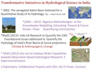
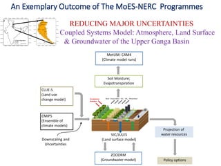
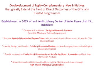
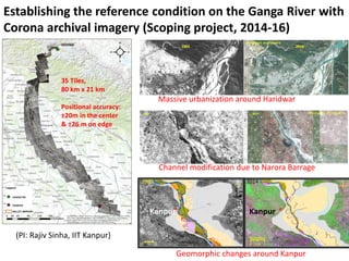
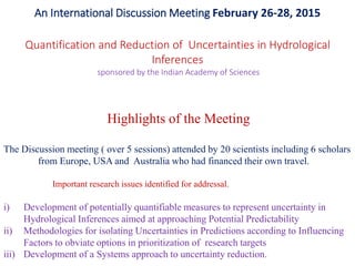
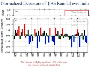
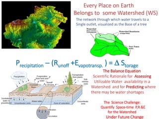
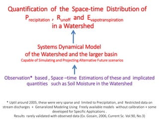
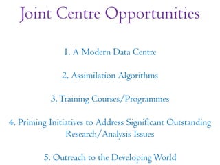
Application of GIS and MODFLOW to Ground Water Hydrology- A ReviewIJERA Editor
Groundwater is one of the most valuable natural resources, which supports human health, economic
development and ecological diversity. Due to over exploitation, the ground water systems are affected and
require management to maintain the conditions of ground water resources within acceptable limits. With the
development of computers and advances in information technology, efficient techniques for water management
has evolved. The main intent of the paper is to present a comprehensive review on application of GIS
(Geographic Information System) followed by coupling with MODFLOW package for ground water
management and development. Two major areas are discussed stating GIS applications in ground water
hydrology. (i) GIS based subsurface flow and pollution modelling (ii) Selection of artificial recharge sites.
Although the use of these techniques in groundwater studies has rapidly increased since last decade the sucess
rate is very limited. Based on this review , it is concluded that integation of GIS and MODFLOW have great
potential to revolutionize the monitoring and management of vital ground water resources in the future.
Presented by Birhanu Zemadim (IWMI) and Emily Schmidt (IFPRI) at the Nile Basin Development Challenge (NBDC) Science Workshop, Addis Ababa, Ethiopia, 9–10 July 2013
Assessing the ability of SWAT as a water quality model in the Lake Victoria b...Timo Brussée
There is a need for a water quality model for use in the Lake Victoria basin countries in East-Africa. The
region is characterised by data scarcity, a tropical climate and riverine, lacustrine tidal wetlands which form
an important buffer to riverine pollution of the lake. These characteristics of the basin form a challenge for
water quality models. The objective is to state the strengths and weaknesses of a potential water quality
model under these challenging conditions. This objective is executed with the soil water assessment tool
(SWAT) in a catchment of the Lake Victoria Basin as pilot area. The pilot area of the Mara river basin is
hydrologically complex containing tropical and plantation forest, savanna, grasslands, bi-annual agriculture,
shrublands and wetlands. It has varied soil types and bi-annual rain seasons
The study consist of literature research and flow simulation of the transboundary Mara river basin. The
model study aims to characterise the hydrology in the pilot area. The study includes a thorough analysis of
rainfall, stage and flow data. Model preparation steps include the use of weighted-area rainfall estimation
methods, climate model data and empirical derivation of soil input parameters. Discharge calibration
methods include multi-site calibration, by making use of an alternative objective function statistic for the
commonly used Nash-Sutcliffe Efficiency (NSE) called the Kling-Gupta Efficiency (KGE). The literature study
targets previous flow and water quality studies done in tropical or wetland areas, thereby looking to see how
these studies adapted to hydrological modelling with SWAT in tropical or wetland areas, and why theses
adaptions were made. The literature research also includes a comparison of wetland processes in SWAT
with the physical, biological and chemical processes as described in previous studies.
The Mara river basin flow simulation gave a satisfactory model performance for two out of three calibration
sites, thereby being able to give preliminary outputs on water-balance and other flow characteristics. During
research, a number of model, knowledge and data gaps were found to be critical for better understanding
the hydrological and water quality system workings in the Lake Victoria and Mara river basin. From the
model and literature study it is concluded that several issues on data scarcity and hydrological model
processes in the tropics can be overcome. These do not necessarily decrease model performance or
uncertainty in the SWAT model. However, wetland processes are oversimplified in SWAT. Modification and
coupled SWAT models yet have not been able to provide an alternative to the default model that adequately
represents the main flow, sediment and nutrients processes and fluxes that are present in Mara’s wetlands.
Water-Body Area Extraction From High Resolution Satellite Images-An Introduct...CSCJournals
Water resources play an important role in region planning, natural disaster, industrial and agricultural production and so on. Surveying of water-bodies and delineate its features properly is very first step for any planning, especially for places like India, where the land-cover is dominated by water-bodies. Recording images, such as from satellite, sometimes does not reflect the distinguished characteristics of water with non-water features, e.g. shadows of super structures. Image of water body is confused easily with the shadow of skyscraper, since calm water surface induces mirror reflection when it gives birth to echo wave. Over the past decade, a significant amount of research been conducted to extract the water body information from multi-resolution satellite image. The objective of this paper is to review methodologies applied for water body extraction using satellite remote sensing. First, studies on water body detection are treated. Methodological issues related to the use of these methods were summarized. Results from empirical studies, applying water-body extraction techniques are collected and discussed. Important issues for future research are also identified and discussed.
Scale-dependency and Sensitivity of Hydrological Estimations to Land Use and ...Beniamino Murgante
Scale-dependency and Sensitivity of Hydrological Estimations to Land Use and Topography for a Coastal Watershed in Mississippi - Vladimir J. Alarcon and Charles G. O’Hara
Using Computer-simulated hydrological model (SWAT) to estimate the ground-wat...Dhiraj Jhunjhunwala
This work is the result of a project-based course, Water Resources Engineering. The project is about the estimation of ground-water recharge due to rainfall in a US-based watershed. The semi-distributed hydrological model(SWAT) has been used to simulate the monthly input and output sub-basin-wise streamflow values,which have been used to compute the total infiltration. The results have been depicted in th form of various monthy and yearly infilration values
Catchment classification: multivariate statistical analyses for physiographic...IJERA Editor
The objective of this study was to determine physiographic similarity, as indicator of hydrologic similarity
between catchments located in the Upper Niger Basin, and to derive the dominant factors controlling each group
singularity. We utilized a dataset of 9 catchments described by 16 physical and climatic properties distributed
across a wide region with strong environmental gradients. Catchments attributes were first standardized before
they underwent an integrated exploratory data analysis composed by Principal Component Analysis (PCA)
followed by Hierarchical Clustering. Results showed a clear distribution into 2 major clusters: a group of
easterly flat catchments and another of westerly hilly catchments. This nomenclature came from the
interpretation of the main factors, topography and longitude, that seem to control the most important variability
between both clusters. In addition, the hilly catchments were designated to be dominated by forest and
ACRISOL soil type, two additional drivers of similarity. The outcome of this study can help understanding
catchment functioning and provide a support for regionalization of hydrological information.
APPLICATION OF GENE EXPRESSION PROGRAMMING IN FLOOD FREQUENCY ANALYSISMohd Danish
Flood frequency and its magnitude are essential for the proper design of hydraulics structures such as bridges, spillways, culverts, waterways, roads, railways, flood control structures and urban drainage systems. Since, flood is a very complex natural event depending upon characteristics of catchment, rainfall conditions and various other factors, thus its analytical modelling is very difficult to pursue. Recently, artificial intelligence techniques such as gene expression programming (GEP), artificial neural network (ANN) etc. have been found to be efficient in modelling complex problems in hydraulic engineering. The performance of GEP model has been reported to be better than that of the ANN. Moreover, GEP provides mathematical equation which makes it more superior over other soft computing techniques that do not give any analytical mathematical equation. Therefore, in present study, GEP is implemented in flood frequency analysis for typical Indian river gauging station. The results obtained in the present study are highly promising and suggest that GEP modelling is a versatile technique and represents an improved alternative to the more conventional approach for the flood frequency analysis.
Presentation highlights the potential of satellite data products, modeling tools and Smart-ICT platform to assist flood-based farming to enable rural people to overcome poverty and improve food productivity while reducing water consumption.
The project demonstrates for the last two flood seasons how satellite data can detect the extent and duration of flooding in various irrigation block and the authorities can make use of such information to know when and where the flood waters are reaching the farm fields and how many days it got inundated. We have also showcased how flood forecasting tools can help downstream authorities to make operational planning including maintenance of irrigation blocks and early warning for local communities.
Contributions of Satellite Images in the Diachronic Study of the Stanley-Pool...INFOGAIN PUBLICATION
With increased population now days, there is a marked change in morphology of the land when it comes the analysis of space images (satellite) using remote sensing. This study covers a sample application of the use of spatial imagery for mapping land cover in the Stanley-Pool (Congo - Brazzaville). The approach used here is based on confrontation of satellite data acquired on different dates (2001-2005). These images were chosen because of realization a demographic growth during this period. The results of this study show a great advance in land occupation which affected the whole of the autonomous port of Brazzaville.
DEEP PERCOLATION CHARACTERTISTICS VIA SOIL MOISTURE SENSOR APPROACH IN SAIGON...IAEME Publication
As a critical factor of the groundwater balance, the deeper percolation rate plays
an essential role in determining sustainable yields for groundwater resources,
especially in water managements for consecutive drought years. Although, there are
many methods to estimate deeper percolation, investigation of deeper percolation
somehow remains a challenging task. Hence, the paper focused on to explore deep
percolation characteristics of three soil type utilizing Richard’s function (Hydrus 1D)
and observed soil moisture via field moisture sensors. The maximum deep percolation
rate of sand clay loam, sand clay, and clay are estimated to be 4.5 mm/day, 3.5
mm/day, and 2.4 mm/day, respectively. The annual percolation ratios of sand clay
loam, sand clay, and clay are 0.34, 0.27 and 0.04, respectively. The average monthly
percolation rates of sand clay loam, sand clay, and clay vary 2-4.5 mm/day, 1.5-3.5
mm/day, and 0.5-2 mm/day, respectively with the rainfall intensity of 4-14 mm/day.
The experiment gave an insight on deeper percolation characteristics as well as
potential land recharge from rainfall utilizing soil moisture approach for future
groundwater balance evaluation
A REVIEW ON RESERVOIR SEDIMENTATION STUDIES USING SATELLITE REMOTE SENSING TE...ijiert bestjournal
Sedimentation in the reservoir gradually reduces it s storage capacity. By keeping a check on the sedimentation and by providing control measures for the same,the reservoir life can be maintained. Uj jani dam was constructed for irrigation,water supply an d power generation schemes. It lies in Solapur dist rict which is a drought prone area. This makes Ujjani a socially and economically significant project for t he state. In the present study,reservoir sedimentatio n for Ujjani reservoir is assessed for monitoring p urpose. Two techniques namely Satellite Remote Sensing Tech nique (SRST) and mathematical modeling using HEC RAS,were used in the study for estimating sedi mentation. Owing to advantages like low cost,time saving,less manpower requirement,accuracy in esti mation and capability of carrying out past surveys,the Satellite Remote Sensing Technique is gaining impor tance over the time consuming and high cost conventional hydrographic surveys. The water spread areas for different reservoir levels were delineat ed from the satellite images of Ujjain Reservoir using ARC GIS software. Volume between two water levels was calculated using prismoidul formula. The presen t volume of reservoir was compared with the initial volume during impoundment of reservoir. This gave t he loss of volume which was due to sedimentation.
A novel fuzzy rule based system for assessment of ground water potability: A ...IOSR Journals
Abstract: Groundwater is an important water resource for domestic, irrigation, and industrial needs. The most
widely exploited use of this resource is for consumption. Assessment of potability of any ground water samples
is a non-trivial task. A new fuzzy rule based system has been proposed to assess the quality of ground-water
samples collected from the bore-wells across 24 districts of Karnataka (South India). Eight groundwater quality
salts parameters are selected for water quality analysis. A membership function for the fuzzy rule based system
for each salt is developed and the weights for each parameter was calculated using Analytic Hierarchy Process
(AHP) that relies on pair wise comparison. The system showed that out of 24 districts of Karnataka state,
ground water from 51.78% bore-wells was not feasible for consumption.
Keywords: Groundwater quality, Fuzzy rule based system
Nel seminario viene descritta una piattaforma informatica integrata, basata su tecnologie GIS, generatori di griglia, simulatori numerici e visualizzatori, finalizzata ad indagare l'impatto sulla qualità delle acque derivante da fonti di inquinamento localizzate e diffuse e a quantificare l'incertezza nell'applicazione dei modelli.
DSD-INT 2016 Regional groundwater flow systems in the Kenya Rift Valley - Mur...Deltares
Presentation by Patrick Murunga Wakhungu (University of Twente) at the iMOD International User Day, during Delft Software Days 2016. Tuesday 1 November 2016, Delft.
Presented by Charlotte MacAlister, Birhanu Zemadim, Teklu Erkossa, Amare Haileslassie, Dan Fuka, Tammo Steenhuis, Solomon Seyoum, Holger Hoff, Kinde Getnet, and Nancy Johnson to the Nile Basin Development ChallengeScience and Reflection Workshop, Addis Ababa, 4-6 May 2011
Groundwater models are simplified representation of large and real hydrogeologic systems like river basins or watersheds. GWM is attempted to analyse the mechanisms which control the occurrence and movement of groundwater and to evaluate the policies, actions and designs which may affect the systems. These models are less complex prototypes of complex hydrogeologic systems developed using spatially varying aquifer parameters, hydrologic properties, geologic boundary conditions and positions of withdrawal wells or recharging structures. These are designed to compute how pumping or recharge might affect the local or regional groundwater levels.
Remote sensing to estimate the mean discharge of rivers from the Himalayan Foreland.
Kumar Gaurav (Indian Institute of Science Education and Research Bhopal Madhya Pradesh)
Artificial Reefs by Kuddle Life Foundation - May 2024punit537210
Situated in Pondicherry, India, Kuddle Life Foundation is a charitable, non-profit and non-governmental organization (NGO) dedicated to improving the living standards of coastal communities and simultaneously placing a strong emphasis on the protection of marine ecosystems.
One of the key areas we work in is Artificial Reefs. This presentation captures our journey so far and our learnings. We hope you get as excited about marine conservation and artificial reefs as we are.
Please visit our website: https://kuddlelife.org
Our Instagram channel:
@kuddlelifefoundation
Our Linkedin Page:
https://www.linkedin.com/company/kuddlelifefoundation/
and write to us if you have any questions:
info@kuddlelife.org
UNDERSTANDING WHAT GREEN WASHING IS!.pdfJulietMogola
Many companies today use green washing to lure the public into thinking they are conserving the environment but in real sense they are doing more harm. There have been such several cases from very big companies here in Kenya and also globally. This ranges from various sectors from manufacturing and goes to consumer products. Educating people on greenwashing will enable people to make better choices based on their analysis and not on what they see on marketing sites.
WRI’s brand new “Food Service Playbook for Promoting Sustainable Food Choices” gives food service operators the very latest strategies for creating dining environments that empower consumers to choose sustainable, plant-rich dishes. This research builds off our first guide for food service, now with industry experience and insights from nearly 350 academic trials.
Characterization and the Kinetics of drying at the drying oven and with micro...Open Access Research Paper
The objective of this work is to contribute to valorization de Nephelium lappaceum by the characterization of kinetics of drying of seeds of Nephelium lappaceum. The seeds were dehydrated until a constant mass respectively in a drying oven and a microwawe oven. The temperatures and the powers of drying are respectively: 50, 60 and 70°C and 140, 280 and 420 W. The results show that the curves of drying of seeds of Nephelium lappaceum do not present a phase of constant kinetics. The coefficients of diffusion vary between 2.09.10-8 to 2.98. 10-8m-2/s in the interval of 50°C at 70°C and between 4.83×10-07 at 9.04×10-07 m-8/s for the powers going of 140 W with 420 W the relation between Arrhenius and a value of energy of activation of 16.49 kJ. mol-1 expressed the effect of the temperature on effective diffusivity.
Diabetes is a rapidly and serious health problem in Pakistan. This chronic condition is associated with serious long-term complications, including higher risk of heart disease and stroke. Aggressive treatment of hypertension and hyperlipideamia can result in a substantial reduction in cardiovascular events in patients with diabetes 1. Consequently pharmacist-led diabetes cardiovascular risk (DCVR) clinics have been established in both primary and secondary care sites in NHS Lothian during the past five years. An audit of the pharmaceutical care delivery at the clinics was conducted in order to evaluate practice and to standardize the pharmacists’ documentation of outcomes. Pharmaceutical care issues (PCI) and patient details were collected both prospectively and retrospectively from three DCVR clinics. The PCI`s were categorized according to a triangularised system consisting of multiple categories. These were ‘checks’, ‘changes’ (‘change in drug therapy process’ and ‘change in drug therapy’), ‘drug therapy problems’ and ‘quality assurance descriptors’ (‘timer perspective’ and ‘degree of change’). A verified medication assessment tool (MAT) for patients with chronic cardiovascular disease was applied to the patients from one of the clinics. The tool was used to quantify PCI`s and pharmacist actions that were centered on implementing or enforcing clinical guideline standards. A database was developed to be used as an assessment tool and to standardize the documentation of achievement of outcomes. Feedback on the audit of the pharmaceutical care delivery and the database was received from the DCVR clinic pharmacist at a focus group meeting.
"Understanding the Carbon Cycle: Processes, Human Impacts, and Strategies for...MMariSelvam4
The carbon cycle is a critical component of Earth's environmental system, governing the movement and transformation of carbon through various reservoirs, including the atmosphere, oceans, soil, and living organisms. This complex cycle involves several key processes such as photosynthesis, respiration, decomposition, and carbon sequestration, each contributing to the regulation of carbon levels on the planet.
Human activities, particularly fossil fuel combustion and deforestation, have significantly altered the natural carbon cycle, leading to increased atmospheric carbon dioxide concentrations and driving climate change. Understanding the intricacies of the carbon cycle is essential for assessing the impacts of these changes and developing effective mitigation strategies.
By studying the carbon cycle, scientists can identify carbon sources and sinks, measure carbon fluxes, and predict future trends. This knowledge is crucial for crafting policies aimed at reducing carbon emissions, enhancing carbon storage, and promoting sustainable practices. The carbon cycle's interplay with climate systems, ecosystems, and human activities underscores its importance in maintaining a stable and healthy planet.
In-depth exploration of the carbon cycle reveals the delicate balance required to sustain life and the urgent need to address anthropogenic influences. Through research, education, and policy, we can work towards restoring equilibrium in the carbon cycle and ensuring a sustainable future for generations to come.
Micro RNA genes and their likely influence in rice (Oryza sativa L.) dynamic ...Open Access Research Paper
Micro RNAs (miRNAs) are small non-coding RNAs molecules having approximately 18-25 nucleotides, they are present in both plants and animals genomes. MiRNAs have diverse spatial expression patterns and regulate various developmental metabolisms, stress responses and other physiological processes. The dynamic gene expression playing major roles in phenotypic differences in organisms are believed to be controlled by miRNAs. Mutations in regions of regulatory factors, such as miRNA genes or transcription factors (TF) necessitated by dynamic environmental factors or pathogen infections, have tremendous effects on structure and expression of genes. The resultant novel gene products presents potential explanations for constant evolving desirable traits that have long been bred using conventional means, biotechnology or genetic engineering. Rice grain quality, yield, disease tolerance, climate-resilience and palatability properties are not exceptional to miRN Asmutations effects. There are new insights courtesy of high-throughput sequencing and improved proteomic techniques that organisms’ complexity and adaptations are highly contributed by miRNAs containing regulatory networks. This article aims to expound on how rice miRNAs could be driving evolution of traits and highlight the latest miRNA research progress. Moreover, the review accentuates miRNAs grey areas to be addressed and gives recommendations for further studies.
2. * 2002: The variegated Kabini Basin Selected for a
Quantitative Study of its Hydrology: IISc – Indo French Cell
Transformative Initiatives in Hydrological Science in India
*(2005 – 2012) Rigorous Methodologies at IISc:
Groundwater Modelling, Estimating Present & Future
Stream Flows Quantifiying Uncertainties
*MoES (2012): Indo-UK Research to Quantify the CWC
Foundational Issues addressed to Quantify the
Hydrology of India’s River Basins & future projections:
Climate & Anthropogenic Change
* MoES (2012) sets out to Catalyze Wider Capabilities
towards Observation Based Hydrological Research: 3
Experimental basins
2 Exploratory Collaborative Projects with CEH, UK ( E-Flows, Cosmos)
3. REDUCING MAJOR UNCERTAINTIES
A Coupled Systems Model: Atmosphere, Land Surface
& Groundwater of the Upper Ganga Basin
VIC/JULES
(Land surface model)
ZOODRM
(Groundwater model)
CMIP5
(Ensemble of
climate models)
MetUM: CAM4
(Climate model runs)
Projection of
water resources
Policy options
Downscaling and
Uncertainties
Soil Moisture;
Evapotranspiration
CLUE-S
(Land use
change model)
An Exemplary Outcome of The MoES-NERC Programmes
4. New Endeavours on the Anvil
standing on the shoulders of
Recent accomplishments: Two Examples
*A systems Dynamical Model of the Kaveri Basin by upscaling the
models constructed for the variegated Hydrological Response Units of
the Kabini Basin
* A systems Dynamical Model with coupled anthropogenic response, of
the Gandak sub-basin in the Ganga basin by incorporating the
knowledge gained during the conduct of the recently concluded CWC
project
5. Co-development of highly Complementary New Initiatives
that greatly Extend the Field of Direct Outcomes of the Officially
funded Programmes
Establishment in 2015, of an Interdisciplinary Centre of Water Research at IISc,
Bangalore
* Catalyze Articulation of Farsighted Research Problems
(Scientific Meetings/ Training Programmes)
* Produce Rigorously Researched Reports/Papers on Important Issues of Concern to Society (Ex: The
Chennai Flood)
* Identify, Design, and Conduct Scholarly Discussion Meetings on New Emerging Issues in Hydrological
Science and Practice
* Special emphasis on Production & Dissemination of Socially significant Knowledge and Real time
Information Products
* Attract International Attention to address cutting Edge Research Issues through
high Impact Intellectual Collaboration
6. 35 Tiles,
80 km x 21 km
Positional accuracy:
±20m in the center
& ±26 m on edge
Establishing the reference condition on the Ganga River with
Corona archival imagery (Scoping project, 2014-16)
Massive urbanization around Haridwar
Channel modification due to Narora Barrage
Kanpur Kanpur
Geomorphic changes around Kanpur
(PI: Rajiv Sinha, IIT Kanpur)
1965 2014
7. An International Discussion Meeting February 26-28, 2015
Quantification and Reduction of Uncertainties in Hydrological
Inferences
sponsored by the Indian Academy of Sciences
Highlights of the Meeting
The Discussion meeting ( over 5 sessions) attended by 20 scientists including 6 scholars
from Europe, USA and Australia who had financed their own travel.
Important research issues identified for addressal.
i) Development of potentially quantifiable measures to represent uncertainty in
Hydrological Inferences aimed at approaching Potential Predictability
ii) Methodologies for isolating Uncertainties in Predictions according to Influencing
Factors to obviate options in prioritization of research targets
iii) Development of a Systems approach to uncertainty reduction.
8. Normalized Departure of JJAS Rainfall over India
The Decreasing Trend of the multi-Decadal Variability since 1955
The Decrease is Highly significant, 7% of the mean
and extensive in time, 6 decades long
10. Eddy Covariance and Cosmos Site at IIT Kanpur
Jointly with the Centre for Ecology & Hydrology, UK
11. Soil moisture products From
Space:
The Challenge: To merge them into A
Better Estimate
Spatialresolution(m)
10 20 30
102
103
104
105
MAPSM
Temporal resolution (days)
RISAT-1
MAPSM
Passive (SMOS & SMAP)
Spatial res. --> ~25/10 km
Temporal res. --> ~3 days
Active (RADARSAT-2)
(RISAT-1)
Spatial res. --> ~100m
Temporal res. --> ~24 days
MAPSM: Merged Active and Passive Soil Moisture
SMOS/
SMAP
Spatial res. --> ~500 m
Temporal res. --> ~3 days
11
12. Evapotranspiration
Modeling
Validation of ET derived from Space Data, at 5 sites
with > 200 clear sky images , during 2009-12.
The figure shows ET, using S-SEBI and Triangle methods
from the Terra and Aqua, Compared with those calculated
from ground observations by the BREB tower of SAC, ISRO.
0
50
100
150
200
250
300
350
400
0 50 100 150 200 250 300 350 400
LatentHeatfromSatelite(Wm-2)
LatentHeat fromAMS towers (Wm-2)
Madhya Pradesh
Dehradun
Karnataka
Rajasthan
WestBengal
R2 = 0.57
RMSE = 46 Wm-2
Bias = 24 Wm-2
MAE = 38 Wm-2
BREB Tower
at Berambadi 12
15. Precipitation (Runoff +Evapotransp. ) = Storage
The Balance Equation
Scientific Rationale for Assessing
Utilizable Water availability in a
Watershed and for Predicting where
there may be water shortages
The Science Challenge:
Quantify Space-time P,R &E
for the Watershed
Under Future Change
Every Place on Earth
Belongs to some Watershed (WS)
The network through which water travels to a
Single outlet, visualized as the Base of a tree
16. Observation* based , Space –time Estimations of these and implicated
quantities such as Soil Moisture in the Watershed
Quantification of the Space-time Distribution of
Precipitation , Runoff and Evapotranspiration
in a Watershed
Systems Dynamical Model
of the Watershed and the larger basin
Capable of Simulating and Projecting Alternative Future scenarios
* Uptil around 2005, these were very sparse and limited to Precipitation, and Restricted data on
stream discharges + Genaralized Modeling Using Freely available models without calibration + some
developed for Specific Applications .
Results rarely validated with observed data (Ex. Gosain, 2006, Current Sc. Vol.90, No.3)
17. Joint Centre Opportunities
1. A Modern Data Centre
2. Assimilation Algorithms
3.Training Courses/Programmes
4. Priming Initiatives to Address Significant Outstanding
Research/Analysis Issues
5. Outreach to the DevelopingWorld
18. The Next Stage Research Challenges
A continuing endeavour to improve our understanding of the Hydrology-Climate –Human System
and Decision support
1.Scale Issues in Hydrology
Process understanding at smaller watershed scales for upscaling to river basin scales; Downscaling of global datasets (including Projections) to watershed
scales; Nested scale modeling (interactive models at various spatial and time scales).
2. Quantification and reduction of uncertainties (Aleatory & Epistemic)
Relating to: model (process understanding), parameter, data, lack of knowledge, subjectivity, imprecision, spatial and time scales etc.
3. Refinement and Fusion of Retreival Algorithms of hydrologic variables
e.g., Soil Moisture and Evapo-transpiration from Satellite Products.
4. Applications of microvave and hypersepctral Remote Sensing in hydrology
5. Modeling non-stationarity in hydrologic processes, particularly of Extremes under climate change
6. Contaminant transport in surface and groundwater systems.
7. Hydrologic regionalisation of the country with climatic inputs
And, Test of the Hypothesis that the Hydrologic Regionalisation may be Affected by Climate Change
8.Two way feedbacks from land surface processes to climate and back
Providing an understanding of the Hydrometeorology of Floods and Droughts at different Space – Time Scales
9. Application areas, for Informed Decisions Making on water management
Systems models at river basin/watershed/aquifer scales; Conjucntive use (of surface and groundwater); Simulation at Management Scales; Converting flood
waters into a resource, by innovative groundwater recharge/ surface storage methods (d) Use of advanced technologies (e.g., sensor, communication, satellite -
) for monitoring ‘Hydrologic Fluxes (e) Intergated water resource management (including estimation of Environmental flows, Use for irrigation, Hydropower,
flood control etc) at riverbasin/watershed scales