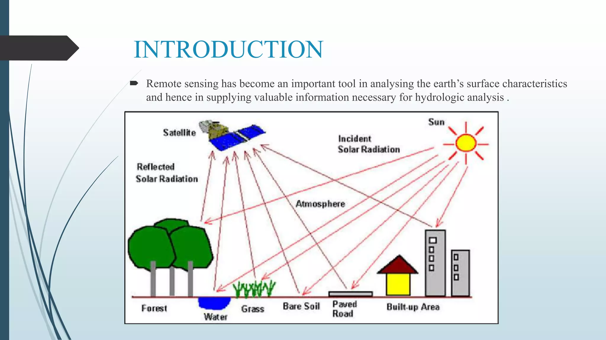
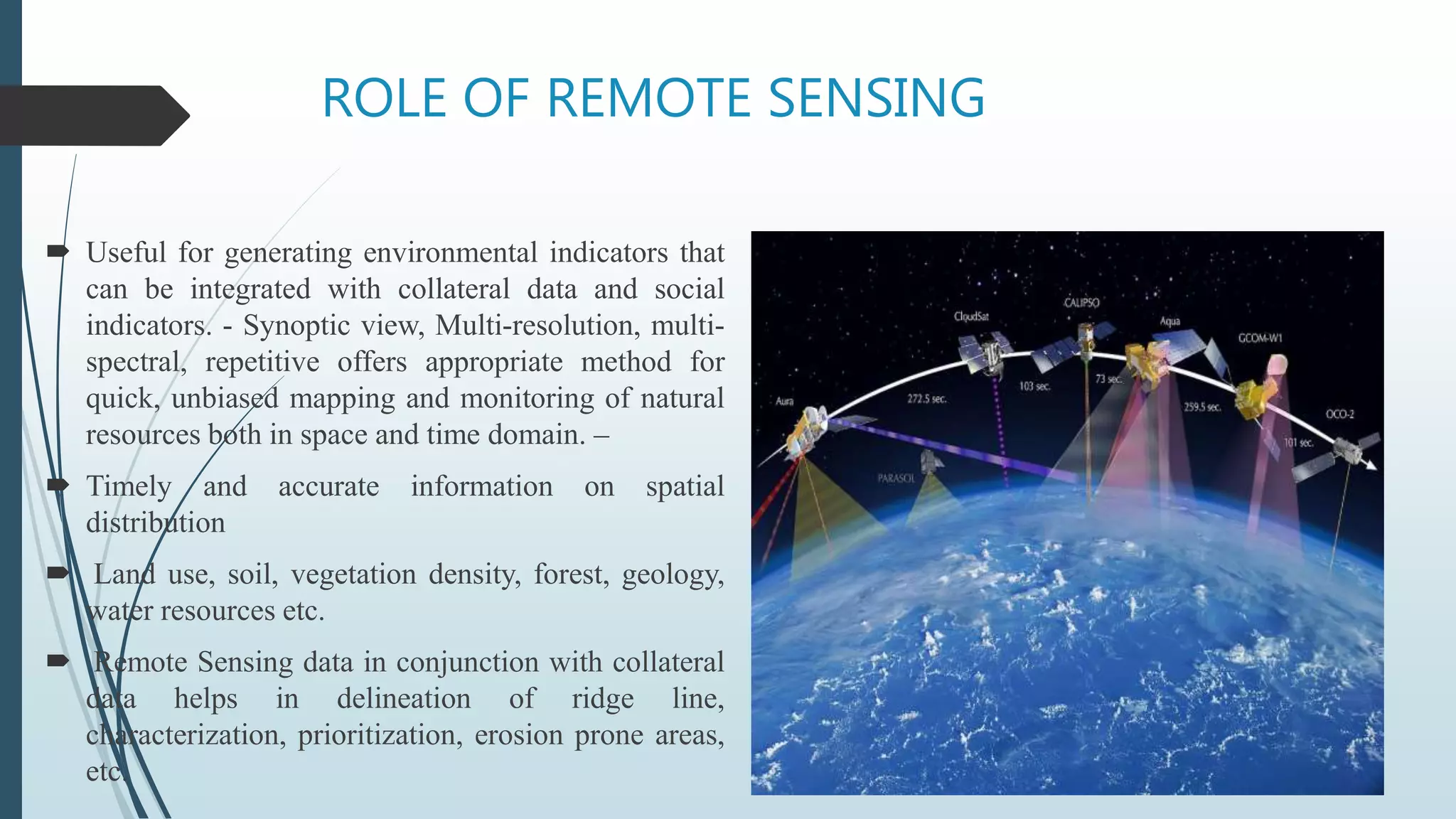
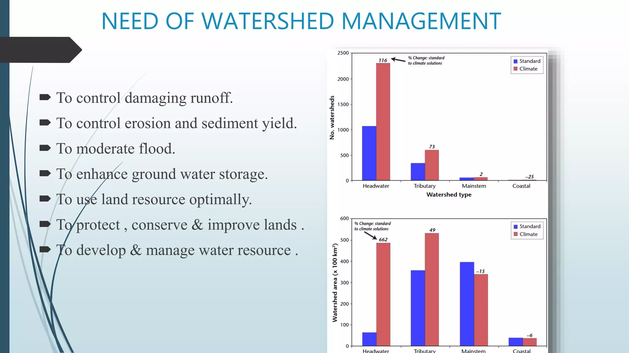
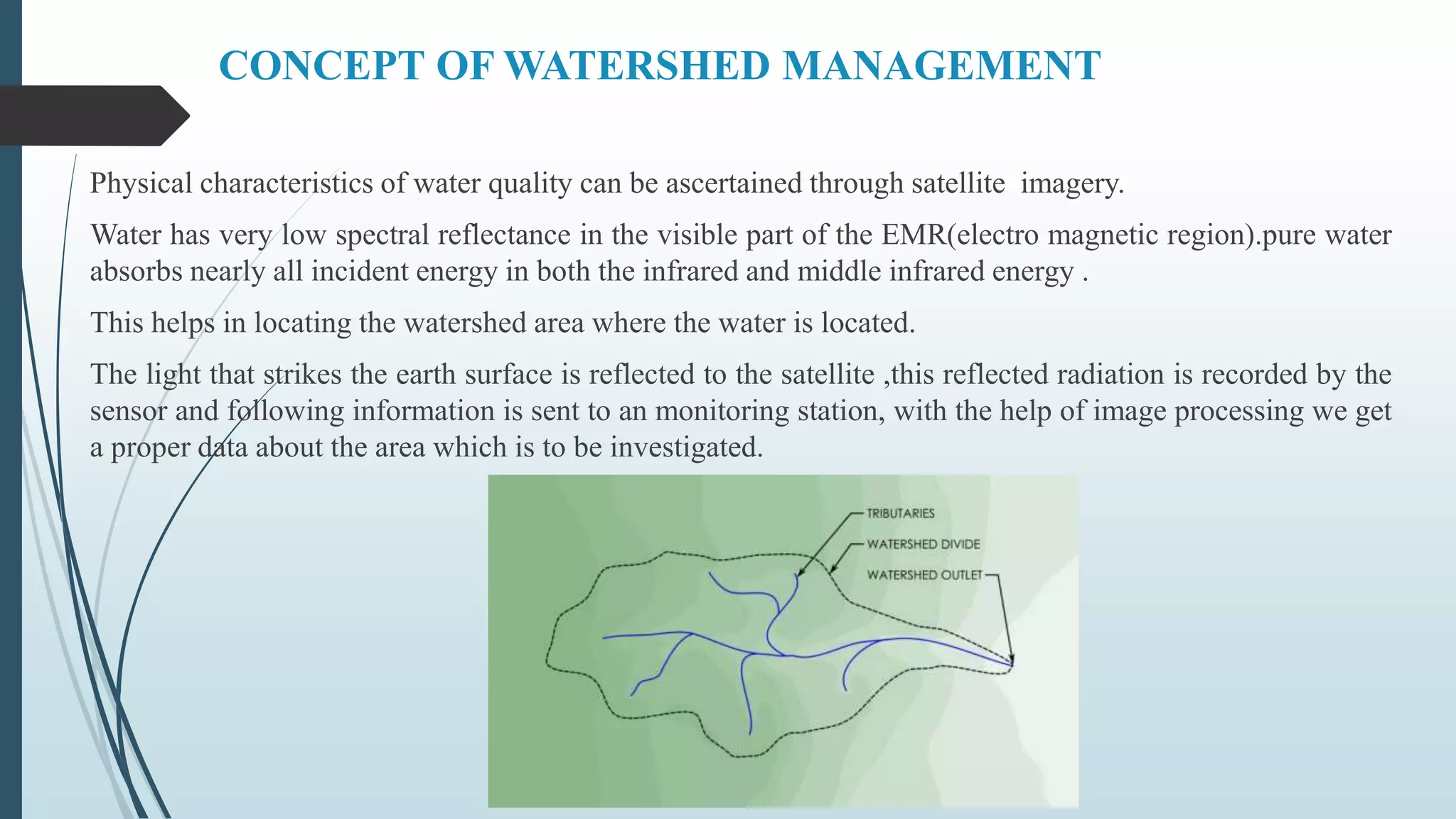
 WATERSHED MANAGEMENT BY REMOTE SENSING AND GIS
WATERSHED MANAGEMENT
BY REMOTE SENSING
Presented By : Harshali Sanjay Deore
Seat No : T150760032
From : T.E. (CIVIL) DIV : A
Seminar Guide : Prof I . J . Bathe
CONTENT
 Introduction
 Role of remote sensing
 Need of watershed management
 Objectives
 Concept of watershed management
 Importance of watershed management in present scenario
 Watershed characteristics
 Benefits derived from watershed management
 Applications
 Conclusion
INTRODUCTION
 Remote sensing has become an important tool in analysing the earth’s surface characteristics
and hence in supplying valuable information necessary for hydrologic analysis .
WATERSHED MANAGEMENT
 Watershed Management
 This is the PROCESS of GUIDING & ORGANISING, Land and Other Resource Usage
in a Watershed Ensuring the Sustenance of the Environment (Mainly the Soil and Water
Resources) i.e., need to recognize the interrelationships between, LAND USE, SOIL-
WATER, and SLOPE OF TERAIN
 Unifying Focus in watershed management is in how various human activities affect the
relationship between water and other natural resources
 Provides a basis for actions concerning the development and Conservation
ROLE OF REMOTE SENSING
 Useful for generating environmental indicators that
can be integrated with collateral data and social
indicators. - Synoptic view, Multi-resolution, multi-
spectral, repetitive offers appropriate method for
quick, unbiased mapping and monitoring of natural
resources both in space and time domain. –
 Timely and accurate information on spatial
distribution
 Land use, soil, vegetation density, forest, geology,
water resources etc.
 Remote Sensing data in conjunction with collateral
data helps in delineation of ridge line,
characterization, prioritization, erosion prone areas,
etc.
NEED OF WATERSHED MANAGEMENT
 To control damaging runoff.
 To control erosion and sediment yield.
 To moderate flood.
 To enhance ground water storage.
 To use land resource optimally.
 To protect , conserve & improve lands .
 To develop & manage water resource .
OBJECTIVES
 • Conservation of Soil and Water
 • Improved ability of land to hold water
 • Maintaining adequate vegetative cover for controlling soil erosion
 • Rain water harvesting and ground water recharging
 Benefits :
 Promotes economic and social development of community
 Employment generation and other income generation
 Ecological balance
CONCEPT OF WATERSHED MANAGEMENT
Physical characteristics of water quality can be ascertained through satellite imagery.
Water has very low spectral reflectance in the visible part of the EMR(electro magnetic region).pure water
absorbs nearly all incident energy in both the infrared and middle infrared energy .
This helps in locating the watershed area where the water is located.
The light that strikes the earth surface is reflected to the satellite ,this reflected radiation is recorded by the
sensor and following information is sent to an monitoring station, with the help of image processing we get
a proper data about the area which is to be investigated.
WATERSHED CODIFICATION
 Alpha-Numeric symbolic codes consisting alternative Arabic numbers and English
alphabet letters are used to designate different stages of delineation.
 In the eighth stage of delineation small letter English alphabet has been used by KSRSAC
to indicate the least area of the watershed.
 WRR’s are assigned Arabic number 1,2,3,…..
 Basins are assigned alphabet capital letters A,B,C,…..
 Catchments are assigned Arabic numbers 1,2,3,…..
 Sub-catchments are assigned alphabet capitol letters A,B,C,…..
 Watersheds are assigned Arabic number 1,2,3,…..
 Sub-watersheds are assigned alphabet capital letters A,B,C,….
 Mini-watersheds are assigned Arabic number 1,2,3,…..
 Micro-watersheds are assigned alphabet small letters a,b,c,…. Example,
 Sub-watershed will have the code 4D3D6A Mini-watershed will have the code
4D3D6A1 Micro-watershed will have the code 4D3D6A1a
IMPORTANCE OF WATERSHED
MANAGEMENT IN PRESENT SCENARIO
 Watershed management or protection implies the proper use of all
the water resource efficiently.
 One of the biggest concern for water based resources in the future is
the sustainability of current and even future water reasource
allocation.
 Watershed management is thus an integral part of any water
reasouse project . The prioritization of watershed i.e which needs to
be paid attension is based on sediment yield potential so that the
treatment would result in minimizing sediment load into reservoir.
WATERSHED CHARACTERISTIC USING
REMOTE SENSING
 SIZE: It helps in computing parameters like precipitation received, retained,
drained off.
 SHAPE: Different shapes based on morphological parameters like geology and
structure, e.g. pear, elongated etc.
 PHISIOGRAPHY: Lands altitude and physical disposition. SLOPE: It controls
the rainfall distribution and movement:
 CLIMATE: It decides the quantitative approach.
 DRAINAGE: It determines the flow characteristics and so the erosion behavior.
 VEGETATION: Information of species gives a sure ground for selection
plants and crops.
 GEOLOGY AND SOILS: Their nature determines size, shape,
physiographic, drainage and groundwater conditions. Soils, derivative of
rocks are the basic to greenery
 HYDROLOGY: Basic to final goal of growing greenery in a watershed.
It helps in quantification of water available.
 HYDROGEOLOGY: Availability of groundwater.
 SOCIOECONOMICS: Statistics on people and their health, hygiene,
wants and wishes are important in managing water.
Benefits derived from Watershed
Methodology
 The crop yield has increased by in dry land farming
 The soil loss due to erosion was brought down
 Large extents of barren hill slopes were covered by vegetation.
 Large tracts of marginal lands brought under dry land Horticulture
 Development of Agro-Horti and Agro-Forestry systems.
 Water resources were harvested through nala bunds, farm ponds, gully
embankments
 Regeneration of grass lands for more fodder and grass.
 The income of farmers increased considerably.
APPLICATION OF WATER REASOURCES
MANAGEMENT IN REMOTE SENSING
 FLOOD MANAGEMENT
 FOREST FIRE
CONCLUSION
 Remote sensing techniques and the data derived using the remote sensing
methods have multidimensional applications in water resources studies.
 Applications of the remote sensing to water resources range from the simple
resource mapping to the complex decision making related to the watershed
characterization and prioritization.
 Remote sensing data used in hydrologic studies are derived from different
passive and active sensors onboard various satellites
 An overview of the remote sensing applications in different fields of water
resources shows the potential of the remote sensing data in water resources
management.
 One of the major advantages of the remote sensing application is the better
spatial and temporal coverage that can be easily obtained to represent the
dynamic nature of the hydrological and meteorological state variables
THANK YOU !

Watershed management by remote sensing

  • 1.
     WATERSHED MANAGEMENTBY REMOTE SENSING AND GIS
  • 2.
    WATERSHED MANAGEMENT BY REMOTESENSING Presented By : Harshali Sanjay Deore Seat No : T150760032 From : T.E. (CIVIL) DIV : A Seminar Guide : Prof I . J . Bathe
  • 3.
    CONTENT  Introduction  Roleof remote sensing  Need of watershed management  Objectives  Concept of watershed management  Importance of watershed management in present scenario  Watershed characteristics  Benefits derived from watershed management  Applications  Conclusion
  • 4.
    INTRODUCTION  Remote sensinghas become an important tool in analysing the earth’s surface characteristics and hence in supplying valuable information necessary for hydrologic analysis .
  • 5.
  • 6.
     Watershed Management This is the PROCESS of GUIDING & ORGANISING, Land and Other Resource Usage in a Watershed Ensuring the Sustenance of the Environment (Mainly the Soil and Water Resources) i.e., need to recognize the interrelationships between, LAND USE, SOIL- WATER, and SLOPE OF TERAIN  Unifying Focus in watershed management is in how various human activities affect the relationship between water and other natural resources  Provides a basis for actions concerning the development and Conservation
  • 7.
    ROLE OF REMOTESENSING  Useful for generating environmental indicators that can be integrated with collateral data and social indicators. - Synoptic view, Multi-resolution, multi- spectral, repetitive offers appropriate method for quick, unbiased mapping and monitoring of natural resources both in space and time domain. –  Timely and accurate information on spatial distribution  Land use, soil, vegetation density, forest, geology, water resources etc.  Remote Sensing data in conjunction with collateral data helps in delineation of ridge line, characterization, prioritization, erosion prone areas, etc.
  • 8.
    NEED OF WATERSHEDMANAGEMENT  To control damaging runoff.  To control erosion and sediment yield.  To moderate flood.  To enhance ground water storage.  To use land resource optimally.  To protect , conserve & improve lands .  To develop & manage water resource .
  • 9.
    OBJECTIVES  • Conservationof Soil and Water  • Improved ability of land to hold water  • Maintaining adequate vegetative cover for controlling soil erosion  • Rain water harvesting and ground water recharging  Benefits :  Promotes economic and social development of community  Employment generation and other income generation  Ecological balance
  • 10.
    CONCEPT OF WATERSHEDMANAGEMENT Physical characteristics of water quality can be ascertained through satellite imagery. Water has very low spectral reflectance in the visible part of the EMR(electro magnetic region).pure water absorbs nearly all incident energy in both the infrared and middle infrared energy . This helps in locating the watershed area where the water is located. The light that strikes the earth surface is reflected to the satellite ,this reflected radiation is recorded by the sensor and following information is sent to an monitoring station, with the help of image processing we get a proper data about the area which is to be investigated.
  • 11.
    WATERSHED CODIFICATION  Alpha-Numericsymbolic codes consisting alternative Arabic numbers and English alphabet letters are used to designate different stages of delineation.  In the eighth stage of delineation small letter English alphabet has been used by KSRSAC to indicate the least area of the watershed.  WRR’s are assigned Arabic number 1,2,3,…..  Basins are assigned alphabet capital letters A,B,C,…..  Catchments are assigned Arabic numbers 1,2,3,…..  Sub-catchments are assigned alphabet capitol letters A,B,C,…..  Watersheds are assigned Arabic number 1,2,3,…..  Sub-watersheds are assigned alphabet capital letters A,B,C,….  Mini-watersheds are assigned Arabic number 1,2,3,…..  Micro-watersheds are assigned alphabet small letters a,b,c,…. Example,  Sub-watershed will have the code 4D3D6A Mini-watershed will have the code 4D3D6A1 Micro-watershed will have the code 4D3D6A1a
  • 13.
    IMPORTANCE OF WATERSHED MANAGEMENTIN PRESENT SCENARIO  Watershed management or protection implies the proper use of all the water resource efficiently.  One of the biggest concern for water based resources in the future is the sustainability of current and even future water reasource allocation.  Watershed management is thus an integral part of any water reasouse project . The prioritization of watershed i.e which needs to be paid attension is based on sediment yield potential so that the treatment would result in minimizing sediment load into reservoir.
  • 14.
    WATERSHED CHARACTERISTIC USING REMOTESENSING  SIZE: It helps in computing parameters like precipitation received, retained, drained off.  SHAPE: Different shapes based on morphological parameters like geology and structure, e.g. pear, elongated etc.  PHISIOGRAPHY: Lands altitude and physical disposition. SLOPE: It controls the rainfall distribution and movement:  CLIMATE: It decides the quantitative approach.  DRAINAGE: It determines the flow characteristics and so the erosion behavior.
  • 15.
     VEGETATION: Informationof species gives a sure ground for selection plants and crops.  GEOLOGY AND SOILS: Their nature determines size, shape, physiographic, drainage and groundwater conditions. Soils, derivative of rocks are the basic to greenery  HYDROLOGY: Basic to final goal of growing greenery in a watershed. It helps in quantification of water available.  HYDROGEOLOGY: Availability of groundwater.  SOCIOECONOMICS: Statistics on people and their health, hygiene, wants and wishes are important in managing water.
  • 16.
    Benefits derived fromWatershed Methodology  The crop yield has increased by in dry land farming  The soil loss due to erosion was brought down  Large extents of barren hill slopes were covered by vegetation.  Large tracts of marginal lands brought under dry land Horticulture  Development of Agro-Horti and Agro-Forestry systems.  Water resources were harvested through nala bunds, farm ponds, gully embankments  Regeneration of grass lands for more fodder and grass.  The income of farmers increased considerably.
  • 17.
    APPLICATION OF WATERREASOURCES MANAGEMENT IN REMOTE SENSING  FLOOD MANAGEMENT
  • 19.
  • 20.
    CONCLUSION  Remote sensingtechniques and the data derived using the remote sensing methods have multidimensional applications in water resources studies.  Applications of the remote sensing to water resources range from the simple resource mapping to the complex decision making related to the watershed characterization and prioritization.  Remote sensing data used in hydrologic studies are derived from different passive and active sensors onboard various satellites  An overview of the remote sensing applications in different fields of water resources shows the potential of the remote sensing data in water resources management.  One of the major advantages of the remote sensing application is the better spatial and temporal coverage that can be easily obtained to represent the dynamic nature of the hydrological and meteorological state variables
  • 21.