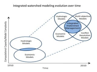
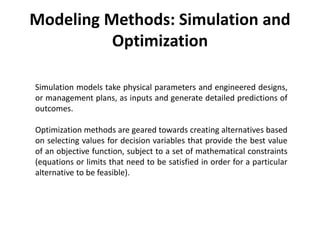
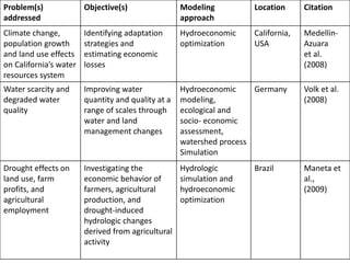
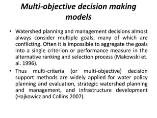
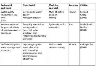
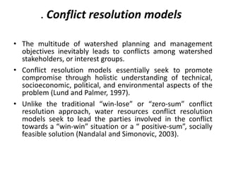
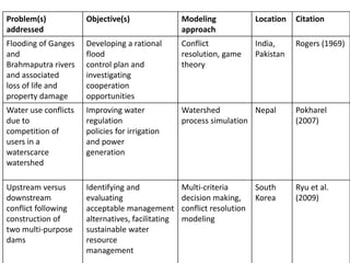
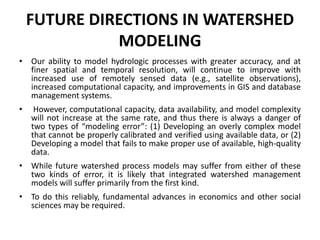
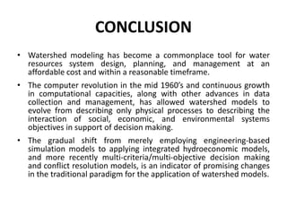
Modernization and Advancement of
Technology for Watershed Planning
and Management in India
By
UPMA SHARMA
RESEARCH SCHOLAR
College of Technology and Engineering, Udaipur (Raj)
Introduction
• Watershed is that area from which all
precipitation flows to a single stream.
Synonyms are “catchment area” and
“drainage basin”.
• The main objective of watershed management
is the "proper use of all the available
resources of a watershed for optimizing
productivity with minimum hazards to natural
resources".
History of Watershed Programmes in
India
• About 60 per cent of total arable land (142 million ha) in India is rain-fed,
characterized by low productivity, low income, low employment with high
incidence of poverty and a bulk of fragile and marginal land (Joshi et al.
2008).
• Watershed development projects in the country has been sponsored and
implemented by Government of India from early 1970s onwards. (Wani et
al. 2005 and 2006).
• Various watershed development programs like Drought Prone Area
Program (DPAP), Desert Development Program (DDP), River Valley Project
(RVP), National Watershed Development Project for Rain-fed Areas
(NWDPRA) and Integrated Wasteland Development Program (IWDP) were
launched subsequently in various hydro-ecological regions, those were
consistently being affected by water stress and draught like situations.
Major Problems of Watershed
Development Programmes Gosain idt
• a “closed” or no-runoff condition
• Widening the gap between the rich and poor.
• contributing to inequitable distribution and use of resources.
• the ownership of water effectively transferred from communal to
private owners.
• are doing little to benefit the poor - and little to achieve the basic
objectives of the programme.
• fixation of the money on per unit area basis being made available to
the PIAs (Project Implementation Agencies).
• ignoring all requirements such as providing transparency, enhancing
accountability, bringing in scientific basis, making evaluation and
tracking improvements to the livelihoods of the poor.
Need for Advanced and Augmented Techniques
for Watershed Management 97833
• The major gap in the evolving watershed management concept at macro or micro level is due
to very limited distribution and exchange of information and datasets caused by different
norms, policies, institutional and organizational factors.
• Technologies are available to solve many watershed problems (irrigation scheduling, water
release cycles in canal command area, etc.).
• Technologies need to be demonstrated in an effective way for easy accomplishment of planes
and Information System for Integrated Watershed Management implementations by the
users.
• the physically based hydrological models are very complex and have lots of input parameters
and, as previously explained, the major problem is being related to availability of adequate
database.
• It was found that technologies alone are not producing the expected results to facilitate
sustainable development and natural resource management. It is vital to carry out further
studies, research and analysis on the concepts and approaches of watershed management.
Studies are required on what has been accomplished with existing ones and how these can
be made even better.
• New concepts and approaches should be developed to reduce the rate of watershed
degradation and to improve agriculture development.
• As watershed management process not only include data related to spatial
and temporal attributes but also includes data related with surface water
storage, ground water recharge and ground water management, hydrology
climatology, agriculture, topography, environmental and socio-economic
aspects.
• Thus, development of entire watershed management decision support
and information system is needed to integrate the Agriculture–Water–
Soil–Climate constituents to accomplish the natural resources
management and, in turn, sustainable development.
• There is a need of appropriate modelling and application of modern
techniques to integrate Agriculture–Water–Soil–Climate environments to
optimize and allocate the land and water resources properly.
• Suitable measures, data, and modern techniques such as GIS, Remote
Sensing and soft computing tools that could be utilized to manage
watersheds imply appropriate technologies at the farmer level and
provide watershed services for upstream and downstream areas.
Role of Geographic Information System (GIS)
and Remote Sensing (RS) in Watershed Management
97833
• A Geographical Information System (GIS) can be defined as a
system, which facilitates the storage and intelligent use of
geographic data and human activities (Srivastava 2003).
• GIS is a tool that allow for the processing of spatial data into
information (Samarakoon 2005).
• Many GIS-based watershed applications have been developed since
the early 1990s due to advances in desktop GIS capabilities,
programming languages, and data availability (Strager et al. 2010).
• GIS offers technologically suitable method for land resource
assessment, delineating different land use patterns, flood
management, irrigation water management, and assessment and
monitoring of environmental impact of watershed projects.
• Remote sensing is the non-contact recording of
information from various electro-magnetic
spectrum regions by means of instruments such
as cameras, scanners, lasers, linear arrays and/or
area arrays located on the ground or arial
platforms (Jensen 2007)
• Remote sensing, with or without GIS technology,
has emerged as an indispensable scientific tool
for mapping and planning of natural resources
(Vittala et al. 2008; Mahajan and Panwar 2005;
Bryan et al. 2011; Burkhard et al. 2012).
THE NEED FOR WATERSHED
MODELING
• In recent years, watershed management practices
that were once praised for their broad benefits
to society have become the focus of harsh
criticisms for their adverse and unexpected
environmental or socioeconomic impacts..
• Watershed models help us predict future
impacts of projects and management policies,
which in turn contributes to improved water
resources system design, planning, and
operation, and thus more sustainable water
resources management
Integrated watershed modeling evolution over time
Modeling Methods: Simulation and
Optimization
Simulation models take physical parameters and engineered designs,
or management plans, as inputs and generate detailed predictions of
outcomes.
Optimization methods are geared towards creating alternatives based
on selecting values for decision variables that provide the best value
of an objective function, subject to a set of mathematical constraints
(equations or limits that need to be satisfied in order for a particular
alternative to be feasible).
Simulation Model Optimization Model
Suitable for “What if” questions “What’s best” questions
Development effort Low High
Computational efficiency High Low
Transparency/ acceptability to
the stakeholders
High Low
Modeling Approaches
• Watershed process models
• Hydroeconomic watershed models
• Multi-objective decision making models
• Conflict resolution models
Watershed process models
• Watershed process simulation models are used for quantitative
analysis, or prediction, of natural processes occurring at the
watershed scale, to understand watersheds’ natural behavior or
their response to human- engineered alterations (Singh and
Woolhiser, 2002).
• Engineering-based watershed process models are frequently
applied in watershed planning and management to help raise the
decision makers’ awareness of technical nuances of proposed
design alternatives, and predict the potential impacts of projects
prior to their implementation.
• Watershed process models have been used in a wide range of
studies, including rainfall-runoff prediction, flood mitigation design,
water supply development, safety assessment of water
infrastructure, land use planning, irrigation planning, hydropower
operations, and surface and groundwater quality protection.
Problem(s)
addressed
Objective(s) Modeling
approach
Location Citation
Water quality
degradation due to
runoff and sediment
transport
Addressing non-point
source pollution
issues
Watershed process
modeling,
phosphorus
loading estimation
Iowa,
USA
Abaci and
Papanicola
ou (2007)
Water quality
deterioration driven
by agricultural
practices
Evaluating the effects
of landscape
characteristics (e.g.
land use, soil type,
and slope) on surface
water quality
Watershed process
simulation
Taiwan Chang et
al. (2008)
Water
overabundance and
scarcity;
flash flooding
followed by periods
of low stream flows
Evaluating impacts of
meteorological
events, land use
change and urban
development on
stream flows
Watershed process
simulation
Mexico Habarth
and
Barkdoll
(2009)
Hydroeconomic watershed models
• Hydroeconomic models, often based on
optimization methods, possess the advantage of
facilitatin economic studies by maximizing or
minimizing some specified economic objective
function subject to a series of constraints.
• Harou et al. (2009) describe hydroeconomic
watershed models as solution-oriented tools that
foster formulation of new strategies to promote
water-use efficiency and transparency of decision
making, thus contributing to integrated water
resources management.
Problem(s)
addressed
Objective(s) Modeling
approach
Location Citation
Climate change,
population growth
and land use effects
on California’s water
resources system
Identifying adaptation
strategies and
estimating economic
losses
Hydroeconomic
optimization
California,
USA
Medellin-
Azuara
et al.
(2008)
Water scarcity and
degraded water
quality
Improving water
quantity and quality at a
range of scales through
water and land
management changes
Hydroeconomic
modeling,
ecological and
socio- economic
assessment,
watershed process
Simulation
Germany Volk et al.
(2008)
Drought effects on
land use, farm
profits, and
agricultural
employment
Investigating the
economic behavior of
farmers, agricultural
production, and
drought-induced
hydrologic changes
derived from agricultural
activity
Hydrologic
simulation and
hydroeconomic
optimization
Brazil Maneta et
al.,
(2009)
Multi-objective decision making
models
• Watershed planning and management decisions almost
always consider multiple goals, many of which are
conflicting. Often it is impossible to aggregate the goals
into a single criterion or performance measure in the
alternative ranking and selection process (Makowski et.
al. 1996).
• Thus multi-criteria (or multi-objective) decision
support methods are widely applied for water policy
planning and evaluation, strategic watershed planning
and management, and infrastructure development
(Hajkowicz and Collins 2007).
Problem(s)
addressed
Objective(s) Modeling
approach
Location Citation
Water quality
impairments in a
river
basin
Developing a water
quality
management plan
Multi-objective
decision
making
Taiwan Lee and
Chang
(2005)
Water scarcity and
long-term impacts
of transbasin water
diversions
Analyzing interactions
among various
drivers of water
shortages and
recommend sustainable
strategies
System dynamics
simulation
Iran Madani and
Marino
(2009)
Inefficient irrigation
water management
strategies
Improving irrigation
water allocation
with respect to
socioeconomic and
environmental
objectives
Multi-criteria
decision making
Greece Latinopoulos
(2009)
. Conflict resolution models
• The multitude of watershed planning and management
objectives inevitably leads to conflicts among watershed
stakeholders, or interest groups.
• Conflict resolution models essentially seek to promote
compromise through holistic understanding of technical,
socioeconomic, political, and environmental aspects of the
problem (Lund and Palmer, 1997).
• Unlike the traditional “win-lose” or “zero-sum” conflict
resolution approach, water resources conflict resolution
models seek to lead the parties involved in the conflict
towards a “win-win” situation or a “ positive-sum”, socially
feasible solution (Nandalal and Simonovic, 2003).
Problem(s)
addressed
Objective(s) Modeling
approach
Location Citation
Flooding of Ganges
and
Brahmaputra rivers
and associated
loss of life and
property damage
Developing a rational
flood
control plan and
investigating
cooperation
opportunities
Conflict
resolution, game
theory
India,
Pakistan
Rogers (1969)
Water use conflicts
due to
competition of
users in a
waterscarce
watershed
Improving water
regulation
policies for irrigation
and power
generation
Watershed
process simulation
Nepal Pokharel
(2007)
Upstream versus
downstream
conflict following
construction of
two multi-purpose
dams
Identifying and
evaluating
acceptable management
alternatives, facilitating
sustainable water
resource
management
Multi-criteria
decision making,
conflict resolution
modeling
South
Korea
Ryu et al.
(2009)
FUTURE DIRECTIONS IN WATERSHED
MODELING
• Our ability to model hydrologic processes with greater accuracy, and at
finer spatial and temporal resolution, will continue to improve with
increased use of remotely sensed data (e.g., satellite observations),
increased computational capacity, and improvements in GIS and database
management systems.
• However, computational capacity, data availability, and model complexity
will not increase at the same rate, and thus there is always a danger of
two types of “modeling error”: (1) Developing an overly complex model
that cannot be properly calibrated and verified using available data, or (2)
Developing a model that fails to make proper use of available, high-quality
data.
• While future watershed process models may suffer from either of these
two kinds of error, it is likely that integrated watershed management
models will suffer primarily from the first kind.
• To do this reliably, fundamental advances in economics and other social
sciences may be required.
CONCLUSION
• Watershed modeling has become a commonplace tool for water
resources system design, planning, and management at an
affordable cost and within a reasonable timeframe.
• The computer revolution in the mid 1960’s and continuous growth
in computational capacities, along with other advances in data
collection and management, has allowed watershed models to
evolve from describing only physical processes to describing the
interaction of social, economic, and environmental systems
objectives in support of decision making.
• The gradual shift from merely employing engineering-based
simulation models to applying integrated hydroeconomic models,
and more recently multi-criteria/multi-objective decision making
and conflict resolution models, is an indicator of promising changes
in the traditional paradigm for the application of watershed models.
References
• Abaci, O. & Papanicolaou, A. N. 2007. Identifying the equilibrium conditions for an agricultural Iowa
catchment using the Water Erosion Prediction Project (WEPP) model.Proceeding of ASCE World
Environmental and Water Resources Congress: Restoring
• Our Natural Habitat, Tampa, Florida.
• Aher P. D., Adinarayana J. , Gorantiwar S. D. , and Sawant S. A. 2014. Information System for Integrated
Watershed Management Using Remote Sensing and GIS, Remote Sensing Applications in Environmental
Research, Springer International Publishing Switzerland .pp 1-19.
• Bryan B. A., King D., Ward J.R. 2011. Modelling and mapping agricultural opportunity costs to guide
landscape planning for natural resource management. Ecol Ind 11(1):199–208
• Burkhard B, Kroll F, Nedkov S, Müller F. 2012. Mapping ecosystem service supply, demand and budgets.
Ecol Ind 21:17–29
• Gosain, A.k. Fallacies in Indian Watershed Management Programme Professor of Civil Engineering
Indian Institute of Technology, Delhi, India .pp. 1-14.
• Hajkowicz, S. & Collins, K. 2007. A review of multiple criteria analysis for water resources planning and
management. Water Resources Management, 21, 1553-1566.
• Habarth, M. L. & Barkdoll, B. 2009. Hydrologic modeling and flood frequency analysis of the Sonora
River Watershed in Sonora, Northwest Mexico. Proceeding of World
• Environmental and Water Resources Congress: Great Rivers, Kansas City, Missouri.
• Harou, J. J., Pulido-Velazquez, M. A., Rosenberg, D. E., Medellin-Azuara, J., Lund, J. R. & Howitt, R. (2009).
Hydro-economic models: concepts, design, applications and future prospects. J. of Hydrol., 375, 334-
350.
• Jensen JR (2007) Remote sensing of the environment: an earth resource perspective, 2nd edn. Prentice
Hall, New Jersey
• Madani, K. & Mariño, M. A. 2009. System dynamics analysis for managing Iran’s Zayandeh-Rud river basin. Water
Resour Manage, 23(11), 2163-2187, doi: 10.1007/s11269-008-9376-z.
• Mahajan S, Panwar P (2005) Land use changes in Ashwani Khad watershed using GIS techniques. J Indian Soc Remote
Sens 33(2):227–232
• Makowski, M., Somlyody, L. & Watkins, D. (1996). Multiple criteria analysis for water quality management in the Nitra
Basin. Water Resources Bulletin, 32, 937–947.
• Maneta, M. P., Torres, M. O., Wallender, W. W., Vosti, S. Howitt, R., Rodrigues, L., Bassoi, L. H. & Panday, S. 2009. A
spatially distributed hydroeconomic model to assess the effects of drought on land use, farm profits, and agricultural
employment. Water Resources Research, 45, 1-19.
• Medellin-Azuara, J., Harou, J. J., Olivares, M. A., Madani, K., Lund, J. R., Howitt, R. E., Tanaka, S. K., Jenkins, M. W. &
Zhu, T. 2008. Adaptability and Adaptations of California’s Water Supply System to Dry Climate Warming. Climatic
Change 87 (Suppl 1), S75-S90.
• Pokharel, S. (2007). Water use opportunities and conflicts in a small watershed - A case study. Renewable and
Sustainable Energy Reviews, 11(6), 1288-1299.
• Rogers, P. 1969. A game theory approach to the problems of international river basins. Water Resources Research,
5(4), 749-760.
• Ryu, J. H., Palmer, R. N., Jeong, S., Lee, J. & Kim, Y. 2009. Sustainable water resources management in the conflict
resolution framework. Journal of the American Water Resources Association, 45(2), 485-499.
• Samarakoon L . 2005. Basic geographic information system (GIS) vector/raster model. ISPRS workshop on remote
sensing and GIS for watershed management, Laos, 2–5 Dec
• Singh, V. P. & Woolhiser, D. A. 2002. Mathematical modeling of watershed hydrology. J. Hydrol. Eng., 7(4), 270-292.
• Srivastava V.K .2003 Role of GIS in natural resources management. In: Thakur B (ed) Perspectives in resource
management in developing countries. Concept Publishing Company, New Delhi, pp 479–484
• Strager MP, Fletcher JJ, Strager JM, Yuill CB, Eli RN, Todd PJ, Lamont SJ. 2010. Watershed analysis with GIS: the
watershed characterization and modeling system software application. Comput Geosci 36(7):970–976
• Vittala SS, Govindaiah S, Gowda HH. 2008 Prioritization of sub-watersheds for sustainable development and
management of natural resources: an integrated approach using remote sensing, GIS and socio-economic data. Curr
Sci 95(3):345–354

Modernization.pptx

  • 1.
    Modernization and Advancementof Technology for Watershed Planning and Management in India By UPMA SHARMA RESEARCH SCHOLAR College of Technology and Engineering, Udaipur (Raj)
  • 2.
    Introduction • Watershed isthat area from which all precipitation flows to a single stream. Synonyms are “catchment area” and “drainage basin”. • The main objective of watershed management is the "proper use of all the available resources of a watershed for optimizing productivity with minimum hazards to natural resources".
  • 3.
    History of WatershedProgrammes in India • About 60 per cent of total arable land (142 million ha) in India is rain-fed, characterized by low productivity, low income, low employment with high incidence of poverty and a bulk of fragile and marginal land (Joshi et al. 2008). • Watershed development projects in the country has been sponsored and implemented by Government of India from early 1970s onwards. (Wani et al. 2005 and 2006). • Various watershed development programs like Drought Prone Area Program (DPAP), Desert Development Program (DDP), River Valley Project (RVP), National Watershed Development Project for Rain-fed Areas (NWDPRA) and Integrated Wasteland Development Program (IWDP) were launched subsequently in various hydro-ecological regions, those were consistently being affected by water stress and draught like situations.
  • 5.
    Major Problems ofWatershed Development Programmes Gosain idt • a “closed” or no-runoff condition • Widening the gap between the rich and poor. • contributing to inequitable distribution and use of resources. • the ownership of water effectively transferred from communal to private owners. • are doing little to benefit the poor - and little to achieve the basic objectives of the programme. • fixation of the money on per unit area basis being made available to the PIAs (Project Implementation Agencies). • ignoring all requirements such as providing transparency, enhancing accountability, bringing in scientific basis, making evaluation and tracking improvements to the livelihoods of the poor.
  • 6.
    Need for Advancedand Augmented Techniques for Watershed Management 97833 • The major gap in the evolving watershed management concept at macro or micro level is due to very limited distribution and exchange of information and datasets caused by different norms, policies, institutional and organizational factors. • Technologies are available to solve many watershed problems (irrigation scheduling, water release cycles in canal command area, etc.). • Technologies need to be demonstrated in an effective way for easy accomplishment of planes and Information System for Integrated Watershed Management implementations by the users. • the physically based hydrological models are very complex and have lots of input parameters and, as previously explained, the major problem is being related to availability of adequate database. • It was found that technologies alone are not producing the expected results to facilitate sustainable development and natural resource management. It is vital to carry out further studies, research and analysis on the concepts and approaches of watershed management. Studies are required on what has been accomplished with existing ones and how these can be made even better. • New concepts and approaches should be developed to reduce the rate of watershed degradation and to improve agriculture development.
  • 7.
    • As watershedmanagement process not only include data related to spatial and temporal attributes but also includes data related with surface water storage, ground water recharge and ground water management, hydrology climatology, agriculture, topography, environmental and socio-economic aspects. • Thus, development of entire watershed management decision support and information system is needed to integrate the Agriculture–Water– Soil–Climate constituents to accomplish the natural resources management and, in turn, sustainable development. • There is a need of appropriate modelling and application of modern techniques to integrate Agriculture–Water–Soil–Climate environments to optimize and allocate the land and water resources properly. • Suitable measures, data, and modern techniques such as GIS, Remote Sensing and soft computing tools that could be utilized to manage watersheds imply appropriate technologies at the farmer level and provide watershed services for upstream and downstream areas.
  • 8.
    Role of GeographicInformation System (GIS) and Remote Sensing (RS) in Watershed Management 97833 • A Geographical Information System (GIS) can be defined as a system, which facilitates the storage and intelligent use of geographic data and human activities (Srivastava 2003). • GIS is a tool that allow for the processing of spatial data into information (Samarakoon 2005). • Many GIS-based watershed applications have been developed since the early 1990s due to advances in desktop GIS capabilities, programming languages, and data availability (Strager et al. 2010). • GIS offers technologically suitable method for land resource assessment, delineating different land use patterns, flood management, irrigation water management, and assessment and monitoring of environmental impact of watershed projects.
  • 9.
    • Remote sensingis the non-contact recording of information from various electro-magnetic spectrum regions by means of instruments such as cameras, scanners, lasers, linear arrays and/or area arrays located on the ground or arial platforms (Jensen 2007) • Remote sensing, with or without GIS technology, has emerged as an indispensable scientific tool for mapping and planning of natural resources (Vittala et al. 2008; Mahajan and Panwar 2005; Bryan et al. 2011; Burkhard et al. 2012).
  • 10.
    THE NEED FORWATERSHED MODELING • In recent years, watershed management practices that were once praised for their broad benefits to society have become the focus of harsh criticisms for their adverse and unexpected environmental or socioeconomic impacts.. • Watershed models help us predict future impacts of projects and management policies, which in turn contributes to improved water resources system design, planning, and operation, and thus more sustainable water resources management
  • 11.
    Integrated watershed modelingevolution over time
  • 12.
    Modeling Methods: Simulationand Optimization Simulation models take physical parameters and engineered designs, or management plans, as inputs and generate detailed predictions of outcomes. Optimization methods are geared towards creating alternatives based on selecting values for decision variables that provide the best value of an objective function, subject to a set of mathematical constraints (equations or limits that need to be satisfied in order for a particular alternative to be feasible).
  • 13.
    Simulation Model OptimizationModel Suitable for “What if” questions “What’s best” questions Development effort Low High Computational efficiency High Low Transparency/ acceptability to the stakeholders High Low
  • 14.
    Modeling Approaches • Watershedprocess models • Hydroeconomic watershed models • Multi-objective decision making models • Conflict resolution models
  • 15.
    Watershed process models •Watershed process simulation models are used for quantitative analysis, or prediction, of natural processes occurring at the watershed scale, to understand watersheds’ natural behavior or their response to human- engineered alterations (Singh and Woolhiser, 2002). • Engineering-based watershed process models are frequently applied in watershed planning and management to help raise the decision makers’ awareness of technical nuances of proposed design alternatives, and predict the potential impacts of projects prior to their implementation. • Watershed process models have been used in a wide range of studies, including rainfall-runoff prediction, flood mitigation design, water supply development, safety assessment of water infrastructure, land use planning, irrigation planning, hydropower operations, and surface and groundwater quality protection.
  • 16.
    Problem(s) addressed Objective(s) Modeling approach Location Citation Waterquality degradation due to runoff and sediment transport Addressing non-point source pollution issues Watershed process modeling, phosphorus loading estimation Iowa, USA Abaci and Papanicola ou (2007) Water quality deterioration driven by agricultural practices Evaluating the effects of landscape characteristics (e.g. land use, soil type, and slope) on surface water quality Watershed process simulation Taiwan Chang et al. (2008) Water overabundance and scarcity; flash flooding followed by periods of low stream flows Evaluating impacts of meteorological events, land use change and urban development on stream flows Watershed process simulation Mexico Habarth and Barkdoll (2009)
  • 17.
    Hydroeconomic watershed models •Hydroeconomic models, often based on optimization methods, possess the advantage of facilitatin economic studies by maximizing or minimizing some specified economic objective function subject to a series of constraints. • Harou et al. (2009) describe hydroeconomic watershed models as solution-oriented tools that foster formulation of new strategies to promote water-use efficiency and transparency of decision making, thus contributing to integrated water resources management.
  • 18.
    Problem(s) addressed Objective(s) Modeling approach Location Citation Climatechange, population growth and land use effects on California’s water resources system Identifying adaptation strategies and estimating economic losses Hydroeconomic optimization California, USA Medellin- Azuara et al. (2008) Water scarcity and degraded water quality Improving water quantity and quality at a range of scales through water and land management changes Hydroeconomic modeling, ecological and socio- economic assessment, watershed process Simulation Germany Volk et al. (2008) Drought effects on land use, farm profits, and agricultural employment Investigating the economic behavior of farmers, agricultural production, and drought-induced hydrologic changes derived from agricultural activity Hydrologic simulation and hydroeconomic optimization Brazil Maneta et al., (2009)
  • 19.
    Multi-objective decision making models •Watershed planning and management decisions almost always consider multiple goals, many of which are conflicting. Often it is impossible to aggregate the goals into a single criterion or performance measure in the alternative ranking and selection process (Makowski et. al. 1996). • Thus multi-criteria (or multi-objective) decision support methods are widely applied for water policy planning and evaluation, strategic watershed planning and management, and infrastructure development (Hajkowicz and Collins 2007).
  • 20.
    Problem(s) addressed Objective(s) Modeling approach Location Citation Waterquality impairments in a river basin Developing a water quality management plan Multi-objective decision making Taiwan Lee and Chang (2005) Water scarcity and long-term impacts of transbasin water diversions Analyzing interactions among various drivers of water shortages and recommend sustainable strategies System dynamics simulation Iran Madani and Marino (2009) Inefficient irrigation water management strategies Improving irrigation water allocation with respect to socioeconomic and environmental objectives Multi-criteria decision making Greece Latinopoulos (2009)
  • 21.
    . Conflict resolutionmodels • The multitude of watershed planning and management objectives inevitably leads to conflicts among watershed stakeholders, or interest groups. • Conflict resolution models essentially seek to promote compromise through holistic understanding of technical, socioeconomic, political, and environmental aspects of the problem (Lund and Palmer, 1997). • Unlike the traditional “win-lose” or “zero-sum” conflict resolution approach, water resources conflict resolution models seek to lead the parties involved in the conflict towards a “win-win” situation or a “ positive-sum”, socially feasible solution (Nandalal and Simonovic, 2003).
  • 22.
    Problem(s) addressed Objective(s) Modeling approach Location Citation Floodingof Ganges and Brahmaputra rivers and associated loss of life and property damage Developing a rational flood control plan and investigating cooperation opportunities Conflict resolution, game theory India, Pakistan Rogers (1969) Water use conflicts due to competition of users in a waterscarce watershed Improving water regulation policies for irrigation and power generation Watershed process simulation Nepal Pokharel (2007) Upstream versus downstream conflict following construction of two multi-purpose dams Identifying and evaluating acceptable management alternatives, facilitating sustainable water resource management Multi-criteria decision making, conflict resolution modeling South Korea Ryu et al. (2009)
  • 23.
    FUTURE DIRECTIONS INWATERSHED MODELING • Our ability to model hydrologic processes with greater accuracy, and at finer spatial and temporal resolution, will continue to improve with increased use of remotely sensed data (e.g., satellite observations), increased computational capacity, and improvements in GIS and database management systems. • However, computational capacity, data availability, and model complexity will not increase at the same rate, and thus there is always a danger of two types of “modeling error”: (1) Developing an overly complex model that cannot be properly calibrated and verified using available data, or (2) Developing a model that fails to make proper use of available, high-quality data. • While future watershed process models may suffer from either of these two kinds of error, it is likely that integrated watershed management models will suffer primarily from the first kind. • To do this reliably, fundamental advances in economics and other social sciences may be required.
  • 24.
    CONCLUSION • Watershed modelinghas become a commonplace tool for water resources system design, planning, and management at an affordable cost and within a reasonable timeframe. • The computer revolution in the mid 1960’s and continuous growth in computational capacities, along with other advances in data collection and management, has allowed watershed models to evolve from describing only physical processes to describing the interaction of social, economic, and environmental systems objectives in support of decision making. • The gradual shift from merely employing engineering-based simulation models to applying integrated hydroeconomic models, and more recently multi-criteria/multi-objective decision making and conflict resolution models, is an indicator of promising changes in the traditional paradigm for the application of watershed models.
  • 25.
    References • Abaci, O.& Papanicolaou, A. N. 2007. Identifying the equilibrium conditions for an agricultural Iowa catchment using the Water Erosion Prediction Project (WEPP) model.Proceeding of ASCE World Environmental and Water Resources Congress: Restoring • Our Natural Habitat, Tampa, Florida. • Aher P. D., Adinarayana J. , Gorantiwar S. D. , and Sawant S. A. 2014. Information System for Integrated Watershed Management Using Remote Sensing and GIS, Remote Sensing Applications in Environmental Research, Springer International Publishing Switzerland .pp 1-19. • Bryan B. A., King D., Ward J.R. 2011. Modelling and mapping agricultural opportunity costs to guide landscape planning for natural resource management. Ecol Ind 11(1):199–208 • Burkhard B, Kroll F, Nedkov S, Müller F. 2012. Mapping ecosystem service supply, demand and budgets. Ecol Ind 21:17–29 • Gosain, A.k. Fallacies in Indian Watershed Management Programme Professor of Civil Engineering Indian Institute of Technology, Delhi, India .pp. 1-14. • Hajkowicz, S. & Collins, K. 2007. A review of multiple criteria analysis for water resources planning and management. Water Resources Management, 21, 1553-1566. • Habarth, M. L. & Barkdoll, B. 2009. Hydrologic modeling and flood frequency analysis of the Sonora River Watershed in Sonora, Northwest Mexico. Proceeding of World • Environmental and Water Resources Congress: Great Rivers, Kansas City, Missouri. • Harou, J. J., Pulido-Velazquez, M. A., Rosenberg, D. E., Medellin-Azuara, J., Lund, J. R. & Howitt, R. (2009). Hydro-economic models: concepts, design, applications and future prospects. J. of Hydrol., 375, 334- 350. • Jensen JR (2007) Remote sensing of the environment: an earth resource perspective, 2nd edn. Prentice Hall, New Jersey
  • 26.
    • Madani, K.& Mariño, M. A. 2009. System dynamics analysis for managing Iran’s Zayandeh-Rud river basin. Water Resour Manage, 23(11), 2163-2187, doi: 10.1007/s11269-008-9376-z. • Mahajan S, Panwar P (2005) Land use changes in Ashwani Khad watershed using GIS techniques. J Indian Soc Remote Sens 33(2):227–232 • Makowski, M., Somlyody, L. & Watkins, D. (1996). Multiple criteria analysis for water quality management in the Nitra Basin. Water Resources Bulletin, 32, 937–947. • Maneta, M. P., Torres, M. O., Wallender, W. W., Vosti, S. Howitt, R., Rodrigues, L., Bassoi, L. H. & Panday, S. 2009. A spatially distributed hydroeconomic model to assess the effects of drought on land use, farm profits, and agricultural employment. Water Resources Research, 45, 1-19. • Medellin-Azuara, J., Harou, J. J., Olivares, M. A., Madani, K., Lund, J. R., Howitt, R. E., Tanaka, S. K., Jenkins, M. W. & Zhu, T. 2008. Adaptability and Adaptations of California’s Water Supply System to Dry Climate Warming. Climatic Change 87 (Suppl 1), S75-S90. • Pokharel, S. (2007). Water use opportunities and conflicts in a small watershed - A case study. Renewable and Sustainable Energy Reviews, 11(6), 1288-1299. • Rogers, P. 1969. A game theory approach to the problems of international river basins. Water Resources Research, 5(4), 749-760. • Ryu, J. H., Palmer, R. N., Jeong, S., Lee, J. & Kim, Y. 2009. Sustainable water resources management in the conflict resolution framework. Journal of the American Water Resources Association, 45(2), 485-499. • Samarakoon L . 2005. Basic geographic information system (GIS) vector/raster model. ISPRS workshop on remote sensing and GIS for watershed management, Laos, 2–5 Dec • Singh, V. P. & Woolhiser, D. A. 2002. Mathematical modeling of watershed hydrology. J. Hydrol. Eng., 7(4), 270-292. • Srivastava V.K .2003 Role of GIS in natural resources management. In: Thakur B (ed) Perspectives in resource management in developing countries. Concept Publishing Company, New Delhi, pp 479–484 • Strager MP, Fletcher JJ, Strager JM, Yuill CB, Eli RN, Todd PJ, Lamont SJ. 2010. Watershed analysis with GIS: the watershed characterization and modeling system software application. Comput Geosci 36(7):970–976 • Vittala SS, Govindaiah S, Gowda HH. 2008 Prioritization of sub-watersheds for sustainable development and management of natural resources: an integrated approach using remote sensing, GIS and socio-economic data. Curr Sci 95(3):345–354