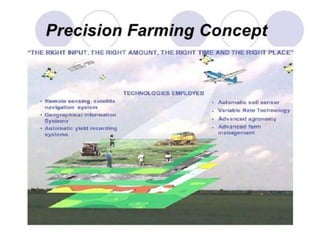
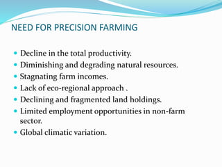
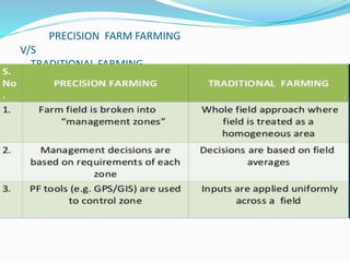
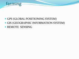
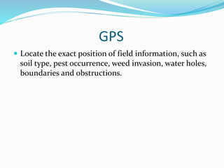
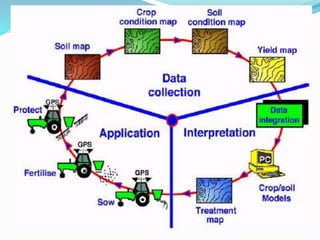
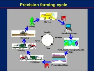
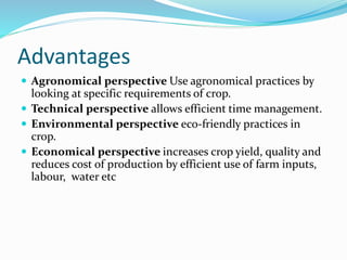
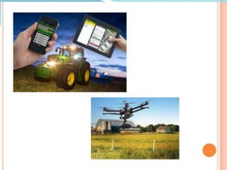
SUMITTED BY
AAKASH
B.TECH AG. ENGINEERING
PRECISION FARMING
 Precision agriculture refers to the precise application of
agricultural inputs with respect to soil, weather and crop
need in order to improve productivity, quality, and
profitability in agriculture.
 It is a modern agriculture practice involving the use of
technology in agriculture like remote sensing, GPS and
GIS for improving productivity and profitability.
 It enables farmers to use crop inputs more efficiently
including pesticides fertilizers, tillage and irrigation
water.
 More effective utilization of inputs will bring in more crop
yield and quality without polluting the environment and
will result in sustainable agriculture and sustainable
development.
 Hence precision agriculture is about doing the right thing,
in the right place, in the right way at the right time.
NEED FOR PRECISION FARMING
 Decline in the total productivity.
 Diminishing and degrading natural resources.
 Stagnating farm incomes.
 Lack of eco-regional approach .
 Declining and fragmented land holdings.
 Limited employment opportunities in non-farm
sector.
 Global climatic variation.
PRECISION FARM FARMING
V/S
TRADITIONAL FARMING
farming
 GPS (GLOBAL POSITIONING SYSTEM)
 GIS (GEOGRAPHIC INFORMATION SYSTEM)
 REMOTE SENSING
GPS
 Locate the exact position of field information, such as
soil type, pest occurrence, weed invasion, water holes,
boundaries and obstructions.
GIS
 SPATIAL DATA GIS COMPUTER
 A geographic information system is a computer system
capable of capturing , storing , manipulating, and
displaying spatially information. Intermediate step because
it combine the data collected based on sampling regimes,
to develop the process models, expert system, etc.
 Weed control
 Pest control site- specific fertilizer application
 Drought monitoring
 Yield estimation
 Pest infestation monitoring and forecasting
Remote Sensing
 Remote sensing has been used in soil mapping, terrain
analysis, crop stress, yield mapping and estimation of
soil organic matter, but on a scale larger than what is
required for precision agriculture.
The specific application of remote sensing techniques can be used
for -
i) Detection
ii) Identification
iii) Measurement
iv) Monitoring of agricultural phenomena
Applicable to crop survey
1. Crop identification 7. Actual yield
2. Crop acreage 8. soil fertility
3. Crop density 9.effects of fertilizes
4. Crop maturity 10. soil toxicity
5. Growth rates 12. soil moisture
6. Yield forecasting 13 water quality
7. Irrigation requirement 14 water availability location
Sensor technologies
 Used to measure humidity, vegetation temperature,
texture, structure, physical character, humidity
nutrient level vapour, air etc
Advantages
 Agronomical perspective Use agronomical practices by
looking at specific requirements of crop.
 Technical perspective allows efficient time management.
 Environmental perspective eco-friendly practices in
crop.
 Economical perspective increases crop yield, quality and
reduces cost of production by efficient use of farm inputs,
labour, water etc
Limitation
 Small farms size.
 Heterogeneity of cropping system.
 High cost of obtaining site-specific data.
 Complexity of tools and techniques requiring new skills.
 Infrastructure and institutional constraints including
market imperfections.
 PF as new story to Indian farmers needs demonstrated
impacts on yields.
 High initial investment.
Conclusion
 PF can immensely help in reducing cost of production and
increase profits and marginal returns.
 It can enable optimal use of input through site-specific
application and precise land leveling by LASER LAND
LEVELER.
 Application of GPS, GIS, Remote sensing and VRT in
finding out crop performance in relation to productivity
liked soil parameters and weather forecasting specially
monsoon.
PRECISION FARMING

PRECISION FARMING

  • 1.
  • 2.
    PRECISION FARMING  Precisionagriculture refers to the precise application of agricultural inputs with respect to soil, weather and crop need in order to improve productivity, quality, and profitability in agriculture.  It is a modern agriculture practice involving the use of technology in agriculture like remote sensing, GPS and GIS for improving productivity and profitability.  It enables farmers to use crop inputs more efficiently including pesticides fertilizers, tillage and irrigation water.
  • 3.
     More effectiveutilization of inputs will bring in more crop yield and quality without polluting the environment and will result in sustainable agriculture and sustainable development.  Hence precision agriculture is about doing the right thing, in the right place, in the right way at the right time.
  • 5.
    NEED FOR PRECISIONFARMING  Decline in the total productivity.  Diminishing and degrading natural resources.  Stagnating farm incomes.  Lack of eco-regional approach .  Declining and fragmented land holdings.  Limited employment opportunities in non-farm sector.  Global climatic variation.
  • 6.
  • 7.
    farming  GPS (GLOBALPOSITIONING SYSTEM)  GIS (GEOGRAPHIC INFORMATION SYSTEM)  REMOTE SENSING
  • 8.
    GPS  Locate theexact position of field information, such as soil type, pest occurrence, weed invasion, water holes, boundaries and obstructions.
  • 9.
    GIS  SPATIAL DATAGIS COMPUTER  A geographic information system is a computer system capable of capturing , storing , manipulating, and displaying spatially information. Intermediate step because it combine the data collected based on sampling regimes, to develop the process models, expert system, etc.  Weed control  Pest control site- specific fertilizer application  Drought monitoring  Yield estimation  Pest infestation monitoring and forecasting
  • 11.
    Remote Sensing  Remotesensing has been used in soil mapping, terrain analysis, crop stress, yield mapping and estimation of soil organic matter, but on a scale larger than what is required for precision agriculture.
  • 12.
    The specific applicationof remote sensing techniques can be used for - i) Detection ii) Identification iii) Measurement iv) Monitoring of agricultural phenomena Applicable to crop survey 1. Crop identification 7. Actual yield 2. Crop acreage 8. soil fertility 3. Crop density 9.effects of fertilizes 4. Crop maturity 10. soil toxicity 5. Growth rates 12. soil moisture 6. Yield forecasting 13 water quality 7. Irrigation requirement 14 water availability location
  • 13.
    Sensor technologies  Usedto measure humidity, vegetation temperature, texture, structure, physical character, humidity nutrient level vapour, air etc
  • 16.
    Advantages  Agronomical perspectiveUse agronomical practices by looking at specific requirements of crop.  Technical perspective allows efficient time management.  Environmental perspective eco-friendly practices in crop.  Economical perspective increases crop yield, quality and reduces cost of production by efficient use of farm inputs, labour, water etc
  • 17.
    Limitation  Small farmssize.  Heterogeneity of cropping system.  High cost of obtaining site-specific data.  Complexity of tools and techniques requiring new skills.  Infrastructure and institutional constraints including market imperfections.  PF as new story to Indian farmers needs demonstrated impacts on yields.  High initial investment.
  • 18.
    Conclusion  PF canimmensely help in reducing cost of production and increase profits and marginal returns.  It can enable optimal use of input through site-specific application and precise land leveling by LASER LAND LEVELER.  Application of GPS, GIS, Remote sensing and VRT in finding out crop performance in relation to productivity liked soil parameters and weather forecasting specially monsoon.