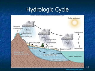
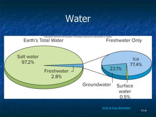
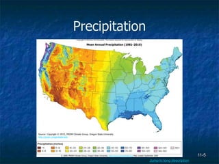
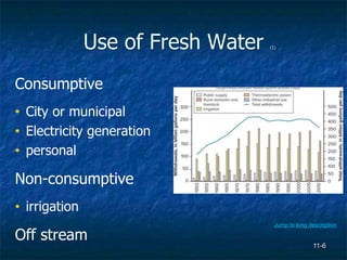
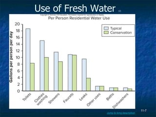
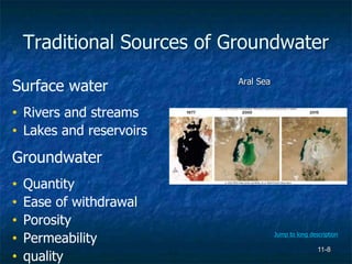
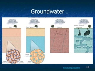
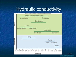
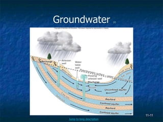
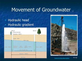
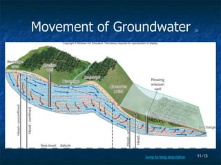
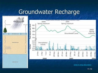
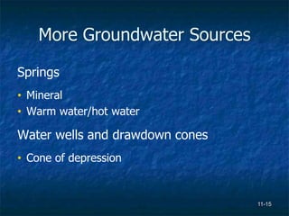
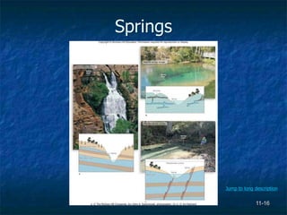
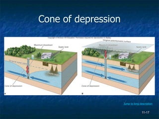
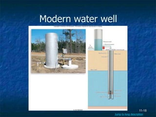
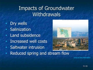
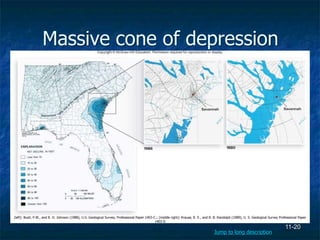
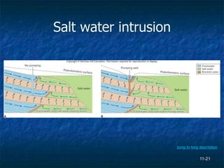
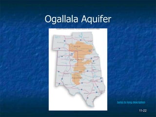
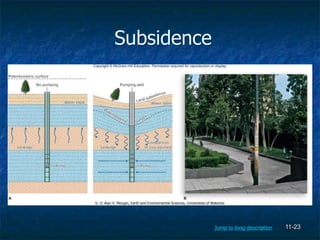
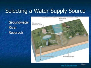
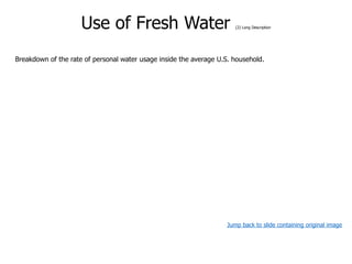
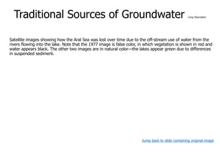
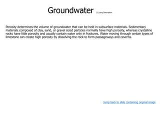
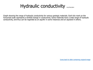
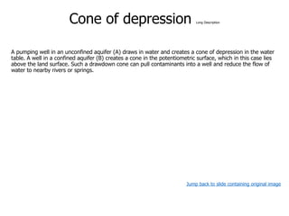
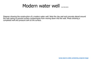
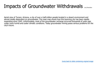
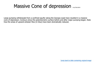
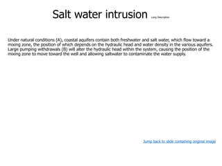
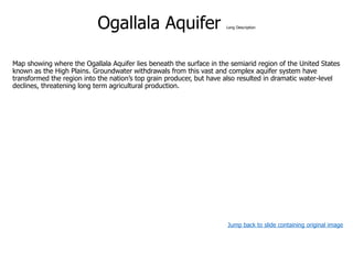
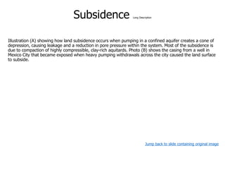
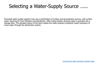
11-1
Environmental
Geology
James Reichard
Copyright © The McGraw-Hill Companies, Inc. Permission required for reproduction or display.
11-2
Chapter 11
Water Resources
Tim McCabe, USDA Natural Resources Conservation Service
11-3
Hydrologic Cycle
Jump to long description
11-4
Water
Jump to long description
11-5
Precipitation
Mean Annual Precipitation (1981-2010)
Source: Copyright © 2015, PRISM Climate Group, Oregon State University
http://prism.oregonstate.edu
© 2009, PRISM Climate Group, Oregon State University, http://www.prismclimate.org Map created September 2009
Jump to long description
11-6
Use of Fresh Water (1)
Consumptive
• City or municipal
• Electricity generation
• personal
Non-consumptive
• irrigation
Off stream
Jump to long description
11-7
Use of Fresh Water (2)
Jump to long description
11-8
Traditional Sources of Groundwater
Surface water
• Rivers and streams
• Lakes and reservoirs
Groundwater
• Quantity
• Ease of withdrawal
• Porosity
• Permeability
• quality
Aral Sea
a: USGS EROS Data Center and NASA; (b-c): NASA’S Earth Observatory
Jump to long description
11-9
Groundwater (1)
Jump to long description
11-10
Hydraulic conductivity
Jump to long description
11-11
Groundwater (2)
Jump to long description
11-12
Movement of Groundwater (1)
• Hydraulic head
• Hydraulic gradient
Alfonso Rivera, Geological Survey of Canada
Jump to long description
11-13
Movement of Groundwater (2)
Jump to long description
11-14
Groundwater Recharge
Jump to long description
11-15
More Groundwater Sources
Springs
• Mineral
• Warm water/hot water
Water wells and drawdown cones
• Cone of depression
11-16
Springs
a: © The McGraw-Hill Companies. Inc./John A. Karachewski, photographer; (b-c): © Jim Reichard
Jump to long description
11-17
Cone of depression
Jump to long description
11-18
Modern water well
© Jim Reichard
Jump to long description
11-19
Impacts of Groundwater
Withdrawals
• Dry wells
• Salinization
• Land subsidence
• Increased well costs
• Saltwater intrusion
• Reduced spring and stream flow
© Richard T. Nowitz/Corbis
Jump to long description
11-20
Massive cone of depression
(left): Bush, P.W., and R. H. Johnson (1988), U.S. Geological Survey, Professional Paper 1403-C.; (middle right): Krause, R. E., and R. B. Randolph (1989), U. S. Geological Survey Professional Paper
1403-D
Jump to long description
11-21
Salt water intrusion
Jump to long description
11-22
Ogallala Aquifer
Jump to long description
11-23
Subsidence
b: © Alan V. Morgan, Earth and Environmental Sciences, Universities of Waterloo
Jump to long description
11-24
Selecting a Water-Supply Source
• Groundwater
• River
• Reservoir
Jump to long description
11-25
Alternative Sources (1)
Desalinization
• Distillation
• Reverse osmosis
Reclaimed/recycled
• Municipal wastewater recycling
• Industrial and domestic recycling
© IDE Technologies
Jump to long description
11-26
Alternative Sources (2)
Aquifer storage and recovery
Rain water harvesting
© Rainwater Services, LLC
Conservation
• Domestic and commercial users
• Agriculture
• Municipal supply systems
Jump to long description
11-27
Irrigation systems
a: © Don Tremain/Getty Images; b: © Clark Dunbar/Corbis
Jeff Vanuga, Natural Resources Conservation Service, US Dept of Agriculture
Jump to long description
11-28
Xeriscaping
A Phoenix, Arizona
B Las Vegas, Nevada
a: © Desert Crest, LLC; b: USDA
Jump to long description
Appendix of Image Long
Descriptions
Hydrologic Cycle Long Description
The hydrologic cycle describes the cyclic movement of water through the Earth system. The cycle is driven
by solar energy that causes water to evaporate from the oceans and land surface and allows for plant
transpiration. Evaporation of seawater produces large quantities of freshwater, which is vital for humans and
the terrestrial biosphere. Humans’ primary sources of freshwater are streams, lakes, and groundwater
systems. Note that groundwater is found in fractured igneous and metamorphic rocks, but the vast majority
occurs in porous sedimentary material.
Jump back to slide containing original image
Water Long Description
Breakdown of the water in Earth’s hydrosphere.
Jump back to slide containing original image
Precipitation Long Description
Average annual precipitation varies widely across the United States, resulting in significant differences in the
availability of freshwater supplies.
Jump back to slide containing original image
Use of Fresh Water (1) Long Description
Total water withdrawals in the United States between 1950 and 2010.
Jump back to slide containing original image
Use of Fresh Water (2) Long Description
Breakdown of the rate of personal water usage inside the average U.S. household.
Jump back to slide containing original image
Traditional Sources of Groundwater Long Description
Satellite images showing how the Aral Sea was lost over time due to the off-stream use of water from the
rivers flowing into the lake. Note that the 1977 image is false color, in which vegetation is shown in red and
water appears black. The other two images are in natural color—the lakes appear green due to differences
in suspended sediment.
Jump back to slide containing original image
Groundwater (1) Long Description
Porosity determines the volume of groundwater that can be held in subsurface materials. Sedimentary
materials composed of clay, sand, or gravel sized particles normally have high porosity, whereas crystalline
rocks have little porosity and usually contain water only in fractures. Water moving through certain types of
limestone can create high porosity by dissolving the rock to form passageways and caverns.
Jump back to slide containing original image
Hydraulic conductivity Long Description
Graph showing the range of hydraulic conductivity for various geologic materials. Each tick mark on the
horizontal scale represents a tenfold change in conductivity. Some materials have a wide range of hydraulic
conductivity, and thus can be regarded as an aquifer in some instances and an aquitard in others.
Jump back to slide containing original image
Groundwater (2) Long Description
An unconfined aquifer is open to the surface environment and has a water table that marks the top of the
saturated zone. A confined aquifer has an overlying aquitard that limits the vertical movement of water,
causing the aquifer to become pressurized. When a well penetrates an aquitard, water rises to the
potentiometric surface, which represents the amount of pressure within the confined aquifer.
Jump back to slide containing original image
Movement of Groundwater (1) Long Description
Illustration showing how hydraulic head and hydraulic gradient in an unconfined aquifer are
determined by measuring the depth of the water in two wells. Note that groundwater flow is
always in the direction of the hydraulic gradient.
A free-flowing artesian well occurs when the potentiometric surface of a confined aquifer is higher
than the land surface, allowing pressurized water to rise above the surface.
Jump back to slide containing original image
Movement of Groundwater(2) Long Description
Water travels between different aquifers by the process of leakage. Downward leakage occurs when the
water table is higher than the potentiometric surface of a confined aquifer. When the potentiometric surface
is higher, leakage is upward.
Jump back to slide containing original image
Groundwater Recharge Long Description
Groundwater recharge occurs when soil moisture builds to the point where water begins to drain
due to gravity. Recharge is less common during hot summer months since most of the water
entering the soil zone is quickly returned to the atmosphere by evaporation and transpiration.
Graph showing how the groundwater level in a semiconfined aquifer in Georgia rises and falls
with the seasons. Between 2000 and 2001 the system was in balance as recharge replaced most
of the water lost due to discharge. Drought conditions in 2002 disrupted the system’s natural
equilibrium, causing the groundwater level to fall. Groundwater levels will return to their normal
maximum provided there is a wet year or series of years with enough recharge to make up for
the water deficit in
the system.
Jump back to slide containing original image
SpringsLong Description
Springs occur where groundwater discharges at the surface in a localized area. The geology of the site
determines the depth of the groundwater source, which in turn influences the spring’s salinity, temperature,
and consistency of flow. The spring in (A) forms when water becomes trapped in the unsaturated zone,
then flows laterally until discharging along a hillside. In (B) the spring discharges from a solution
passageway in limestone. Example (C) illustrates how water from deeper aquifers can flow to the surface
along faults or fractures.
Jump back to slide containing original image
Cone of depression Long Description
A pumping well in an unconfined aquifer (A) draws in water and creates a cone of depression in the water
table. A well in a confined aquifer (B) creates a cone in the potentiometric surface, which in this case lies
above the land surface. Such a drawdown cone can pull contaminants into a well and reduce the flow of
water to nearby rivers or springs.
Jump back to slide containing original image
Modern water well Long Description
Diagram showing the construction of a modern water well. Note the clay seal and concrete placed around
the well casing to prevent surface contaminants from moving down into the well. Photo showing a
completed well and pressure tank at the surface.
Jump back to slide containing original image
Impacts of Groundwater Withdrawals Long Description
Aerial view of Tucson, Arizona, a city of over a half-million people located in a desert environment and
almost totally dependent on groundwater. The inset map shows how this booming city has been rapidly
expanding since 1945. Unfortunately, most of the groundwater recharge occurred thousands of years ago
under more humid and cooler climatic conditions. Today groundwater mining poses serious problems for the
city’s future.
Jump back to slide containing original image
Massive Cone of depression Long Description
Large pumping withdrawals from a confined aquifer along the Georgia coast have resulted in a massive
cone of depression. Contours show the potentiometric surface before and after major pumping began. Note
how the areas of upward artesian flow (in blue) have been dramatically reduced.
Jump back to slide containing original image
Salt water intrusion Long Description
Under natural conditions (A), coastal aquifers contain both freshwater and salt water, which flow toward a
mixing zone, the position of which depends on the hydraulic head and water density in the various aquifers.
Large pumping withdrawals (B) will alter the hydraulic head within the system, causing the position of the
mixing zone to move toward the well and allowing saltwater to contaminate the water supply.
Jump back to slide containing original image
Ogallala Aquifer Long Description
Map showing where the Ogallala Aquifer lies beneath the surface in the semiarid region of the United States
known as the High Plains. Groundwater withdrawals from this vast and complex aquifer system have
transformed the region into the nation’s top grain producer, but have also resulted in dramatic water-level
declines, threatening long term agricultural production.
Jump back to slide containing original image
Subsidence Long Description
Illustration (A) showing how land subsidence occurs when pumping in a confined aquifer creates a cone of
depression, causing leakage and a reduction in pore pressure within the system. Most of the subsidence is
due to compaction of highly compressible, clay-rich aquitards. Photo (B) shows the casing from a well in
Mexico City that became exposed when heavy pumping withdrawals across the city caused the land surface
to subside.
Jump back to slide containing original image
Selecting a Water-Supply Source Long Description
Municipal water-supply systems may use a combination of surface and groundwater sources, with surface
water requiring far more filtration and disinfection. After being treated, drinking water is pumped into a
storage tank. The elevated nature of the tank creates the water pressure (hydraulic head) necessary to
move water through the distribution system.
Jump back to slide containing original image
Alternative Sources (1) Long Description
Aerial view showing Israel’s reverse osmosis plant at Ashkelon, which is one of the largest in the world.
Plants such as this produce highly saline wastewater, which can disrupt marine ecosystems if discharged
directly into the ocean.
Jump back to slide containing original image
Alternative Sources (2) Long Description
Rainwater harvesting systems involve collecting rainwater from a roof, then storing it either above or below
ground in a tank called a cistern. With modifications to a building’s plumbing system, cistern water can be
used in place of drinking water for certain applications.
Jump back to slide containing original image
Irrigation systems Long Description
In older irrigation systems (A) as much as 30% of the water evaporates and never reaches the
ground. Systems can be retrofitted (B) so that water is directed toward the ground, which greatly
reduces evaporative
losses.
Drip-irrigation systems, like this one in a vineyard in New Mexico, are the most efficient as water
is applied only to the root zone of each plant. However, irrigating in this manner is labor-intensive
and involves considerable material costs.
Jump back to slide containing original image
Xeriscaping Long Description
Large reductions in home water use can be realized through landscaping changes. Xeriscaping involves
using native plants (A) rather than nonnative vegetation (B) that requires extensive irrigation.
Jump back to slide containing original image

ENV 101 Ch11 lecture ppt_a

  • 1.
    11-1 Environmental Geology James Reichard Copyright ©The McGraw-Hill Companies, Inc. Permission required for reproduction or display.
  • 2.
    11-2 Chapter 11 Water Resources TimMcCabe, USDA Natural Resources Conservation Service
  • 3.
  • 4.
  • 5.
    11-5 Precipitation Mean Annual Precipitation(1981-2010) Source: Copyright © 2015, PRISM Climate Group, Oregon State University http://prism.oregonstate.edu © 2009, PRISM Climate Group, Oregon State University, http://www.prismclimate.org Map created September 2009 Jump to long description
  • 6.
    11-6 Use of FreshWater (1) Consumptive • City or municipal • Electricity generation • personal Non-consumptive • irrigation Off stream Jump to long description
  • 7.
    11-7 Use of FreshWater (2) Jump to long description
  • 8.
    11-8 Traditional Sources ofGroundwater Surface water • Rivers and streams • Lakes and reservoirs Groundwater • Quantity • Ease of withdrawal • Porosity • Permeability • quality Aral Sea a: USGS EROS Data Center and NASA; (b-c): NASA’S Earth Observatory Jump to long description
  • 9.
  • 10.
  • 11.
  • 12.
    11-12 Movement of Groundwater(1) • Hydraulic head • Hydraulic gradient Alfonso Rivera, Geological Survey of Canada Jump to long description
  • 13.
    11-13 Movement of Groundwater(2) Jump to long description
  • 14.
  • 15.
    11-15 More Groundwater Sources Springs •Mineral • Warm water/hot water Water wells and drawdown cones • Cone of depression
  • 16.
    11-16 Springs a: © TheMcGraw-Hill Companies. Inc./John A. Karachewski, photographer; (b-c): © Jim Reichard Jump to long description
  • 17.
    11-17 Cone of depression Jumpto long description
  • 18.
    11-18 Modern water well ©Jim Reichard Jump to long description
  • 19.
    11-19 Impacts of Groundwater Withdrawals •Dry wells • Salinization • Land subsidence • Increased well costs • Saltwater intrusion • Reduced spring and stream flow © Richard T. Nowitz/Corbis Jump to long description
  • 20.
    11-20 Massive cone ofdepression (left): Bush, P.W., and R. H. Johnson (1988), U.S. Geological Survey, Professional Paper 1403-C.; (middle right): Krause, R. E., and R. B. Randolph (1989), U. S. Geological Survey Professional Paper 1403-D Jump to long description
  • 21.
  • 22.
  • 23.
    11-23 Subsidence b: © AlanV. Morgan, Earth and Environmental Sciences, Universities of Waterloo Jump to long description
  • 24.
    11-24 Selecting a Water-SupplySource • Groundwater • River • Reservoir Jump to long description
  • 25.
    11-25 Alternative Sources (1) Desalinization •Distillation • Reverse osmosis Reclaimed/recycled • Municipal wastewater recycling • Industrial and domestic recycling © IDE Technologies Jump to long description
  • 26.
    11-26 Alternative Sources (2) Aquiferstorage and recovery Rain water harvesting © Rainwater Services, LLC Conservation • Domestic and commercial users • Agriculture • Municipal supply systems Jump to long description
  • 27.
    11-27 Irrigation systems a: ©Don Tremain/Getty Images; b: © Clark Dunbar/Corbis Jeff Vanuga, Natural Resources Conservation Service, US Dept of Agriculture Jump to long description
  • 28.
    11-28 Xeriscaping A Phoenix, Arizona BLas Vegas, Nevada a: © Desert Crest, LLC; b: USDA Jump to long description
  • 29.
    Appendix of ImageLong Descriptions
  • 30.
    Hydrologic Cycle LongDescription The hydrologic cycle describes the cyclic movement of water through the Earth system. The cycle is driven by solar energy that causes water to evaporate from the oceans and land surface and allows for plant transpiration. Evaporation of seawater produces large quantities of freshwater, which is vital for humans and the terrestrial biosphere. Humans’ primary sources of freshwater are streams, lakes, and groundwater systems. Note that groundwater is found in fractured igneous and metamorphic rocks, but the vast majority occurs in porous sedimentary material. Jump back to slide containing original image
  • 31.
    Water Long Description Breakdownof the water in Earth’s hydrosphere. Jump back to slide containing original image
  • 32.
    Precipitation Long Description Averageannual precipitation varies widely across the United States, resulting in significant differences in the availability of freshwater supplies. Jump back to slide containing original image
  • 33.
    Use of FreshWater (1) Long Description Total water withdrawals in the United States between 1950 and 2010. Jump back to slide containing original image
  • 34.
    Use of FreshWater (2) Long Description Breakdown of the rate of personal water usage inside the average U.S. household. Jump back to slide containing original image
  • 35.
    Traditional Sources ofGroundwater Long Description Satellite images showing how the Aral Sea was lost over time due to the off-stream use of water from the rivers flowing into the lake. Note that the 1977 image is false color, in which vegetation is shown in red and water appears black. The other two images are in natural color—the lakes appear green due to differences in suspended sediment. Jump back to slide containing original image
  • 36.
    Groundwater (1) LongDescription Porosity determines the volume of groundwater that can be held in subsurface materials. Sedimentary materials composed of clay, sand, or gravel sized particles normally have high porosity, whereas crystalline rocks have little porosity and usually contain water only in fractures. Water moving through certain types of limestone can create high porosity by dissolving the rock to form passageways and caverns. Jump back to slide containing original image
  • 37.
    Hydraulic conductivity LongDescription Graph showing the range of hydraulic conductivity for various geologic materials. Each tick mark on the horizontal scale represents a tenfold change in conductivity. Some materials have a wide range of hydraulic conductivity, and thus can be regarded as an aquifer in some instances and an aquitard in others. Jump back to slide containing original image
  • 38.
    Groundwater (2) LongDescription An unconfined aquifer is open to the surface environment and has a water table that marks the top of the saturated zone. A confined aquifer has an overlying aquitard that limits the vertical movement of water, causing the aquifer to become pressurized. When a well penetrates an aquitard, water rises to the potentiometric surface, which represents the amount of pressure within the confined aquifer. Jump back to slide containing original image
  • 39.
    Movement of Groundwater(1) Long Description Illustration showing how hydraulic head and hydraulic gradient in an unconfined aquifer are determined by measuring the depth of the water in two wells. Note that groundwater flow is always in the direction of the hydraulic gradient. A free-flowing artesian well occurs when the potentiometric surface of a confined aquifer is higher than the land surface, allowing pressurized water to rise above the surface. Jump back to slide containing original image
  • 40.
    Movement of Groundwater(2)Long Description Water travels between different aquifers by the process of leakage. Downward leakage occurs when the water table is higher than the potentiometric surface of a confined aquifer. When the potentiometric surface is higher, leakage is upward. Jump back to slide containing original image
  • 41.
    Groundwater Recharge LongDescription Groundwater recharge occurs when soil moisture builds to the point where water begins to drain due to gravity. Recharge is less common during hot summer months since most of the water entering the soil zone is quickly returned to the atmosphere by evaporation and transpiration. Graph showing how the groundwater level in a semiconfined aquifer in Georgia rises and falls with the seasons. Between 2000 and 2001 the system was in balance as recharge replaced most of the water lost due to discharge. Drought conditions in 2002 disrupted the system’s natural equilibrium, causing the groundwater level to fall. Groundwater levels will return to their normal maximum provided there is a wet year or series of years with enough recharge to make up for the water deficit in the system. Jump back to slide containing original image
  • 42.
    SpringsLong Description Springs occurwhere groundwater discharges at the surface in a localized area. The geology of the site determines the depth of the groundwater source, which in turn influences the spring’s salinity, temperature, and consistency of flow. The spring in (A) forms when water becomes trapped in the unsaturated zone, then flows laterally until discharging along a hillside. In (B) the spring discharges from a solution passageway in limestone. Example (C) illustrates how water from deeper aquifers can flow to the surface along faults or fractures. Jump back to slide containing original image
  • 43.
    Cone of depressionLong Description A pumping well in an unconfined aquifer (A) draws in water and creates a cone of depression in the water table. A well in a confined aquifer (B) creates a cone in the potentiometric surface, which in this case lies above the land surface. Such a drawdown cone can pull contaminants into a well and reduce the flow of water to nearby rivers or springs. Jump back to slide containing original image
  • 44.
    Modern water wellLong Description Diagram showing the construction of a modern water well. Note the clay seal and concrete placed around the well casing to prevent surface contaminants from moving down into the well. Photo showing a completed well and pressure tank at the surface. Jump back to slide containing original image
  • 45.
    Impacts of GroundwaterWithdrawals Long Description Aerial view of Tucson, Arizona, a city of over a half-million people located in a desert environment and almost totally dependent on groundwater. The inset map shows how this booming city has been rapidly expanding since 1945. Unfortunately, most of the groundwater recharge occurred thousands of years ago under more humid and cooler climatic conditions. Today groundwater mining poses serious problems for the city’s future. Jump back to slide containing original image
  • 46.
    Massive Cone ofdepression Long Description Large pumping withdrawals from a confined aquifer along the Georgia coast have resulted in a massive cone of depression. Contours show the potentiometric surface before and after major pumping began. Note how the areas of upward artesian flow (in blue) have been dramatically reduced. Jump back to slide containing original image
  • 47.
    Salt water intrusionLong Description Under natural conditions (A), coastal aquifers contain both freshwater and salt water, which flow toward a mixing zone, the position of which depends on the hydraulic head and water density in the various aquifers. Large pumping withdrawals (B) will alter the hydraulic head within the system, causing the position of the mixing zone to move toward the well and allowing saltwater to contaminate the water supply. Jump back to slide containing original image
  • 48.
    Ogallala Aquifer LongDescription Map showing where the Ogallala Aquifer lies beneath the surface in the semiarid region of the United States known as the High Plains. Groundwater withdrawals from this vast and complex aquifer system have transformed the region into the nation’s top grain producer, but have also resulted in dramatic water-level declines, threatening long term agricultural production. Jump back to slide containing original image
  • 49.
    Subsidence Long Description Illustration(A) showing how land subsidence occurs when pumping in a confined aquifer creates a cone of depression, causing leakage and a reduction in pore pressure within the system. Most of the subsidence is due to compaction of highly compressible, clay-rich aquitards. Photo (B) shows the casing from a well in Mexico City that became exposed when heavy pumping withdrawals across the city caused the land surface to subside. Jump back to slide containing original image
  • 50.
    Selecting a Water-SupplySource Long Description Municipal water-supply systems may use a combination of surface and groundwater sources, with surface water requiring far more filtration and disinfection. After being treated, drinking water is pumped into a storage tank. The elevated nature of the tank creates the water pressure (hydraulic head) necessary to move water through the distribution system. Jump back to slide containing original image
  • 51.
    Alternative Sources (1)Long Description Aerial view showing Israel’s reverse osmosis plant at Ashkelon, which is one of the largest in the world. Plants such as this produce highly saline wastewater, which can disrupt marine ecosystems if discharged directly into the ocean. Jump back to slide containing original image
  • 52.
    Alternative Sources (2)Long Description Rainwater harvesting systems involve collecting rainwater from a roof, then storing it either above or below ground in a tank called a cistern. With modifications to a building’s plumbing system, cistern water can be used in place of drinking water for certain applications. Jump back to slide containing original image
  • 53.
    Irrigation systems LongDescription In older irrigation systems (A) as much as 30% of the water evaporates and never reaches the ground. Systems can be retrofitted (B) so that water is directed toward the ground, which greatly reduces evaporative losses. Drip-irrigation systems, like this one in a vineyard in New Mexico, are the most efficient as water is applied only to the root zone of each plant. However, irrigating in this manner is labor-intensive and involves considerable material costs. Jump back to slide containing original image
  • 54.
    Xeriscaping Long Description Largereductions in home water use can be realized through landscaping changes. Xeriscaping involves using native plants (A) rather than nonnative vegetation (B) that requires extensive irrigation. Jump back to slide containing original image