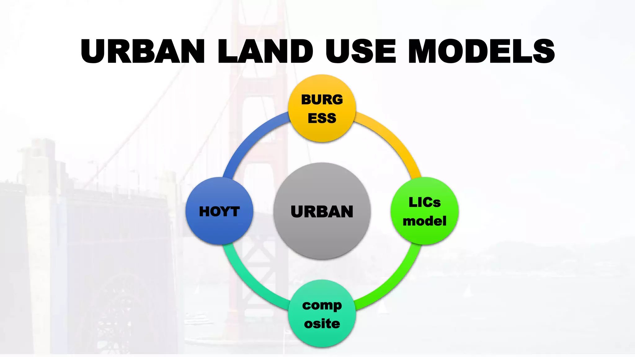
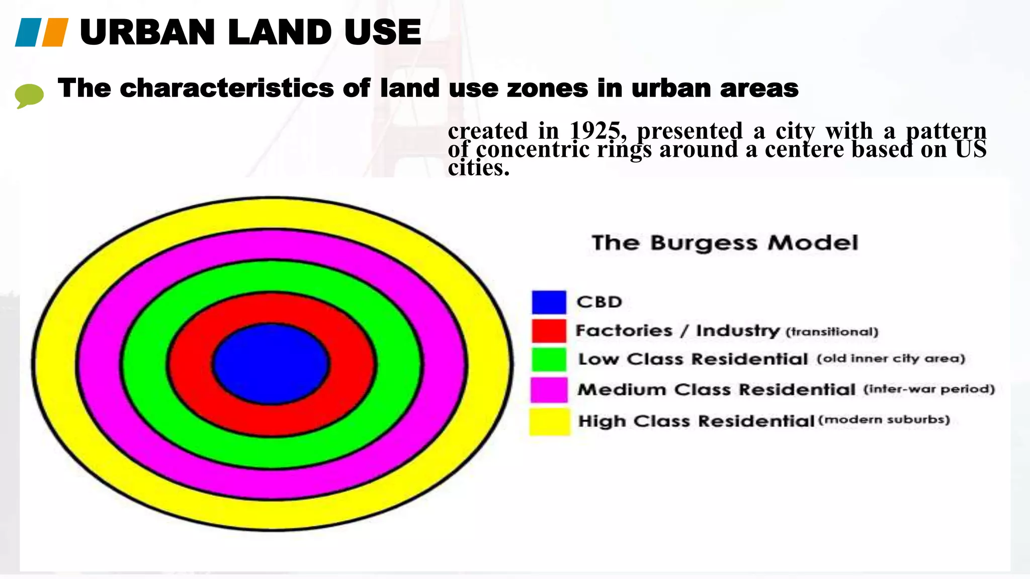
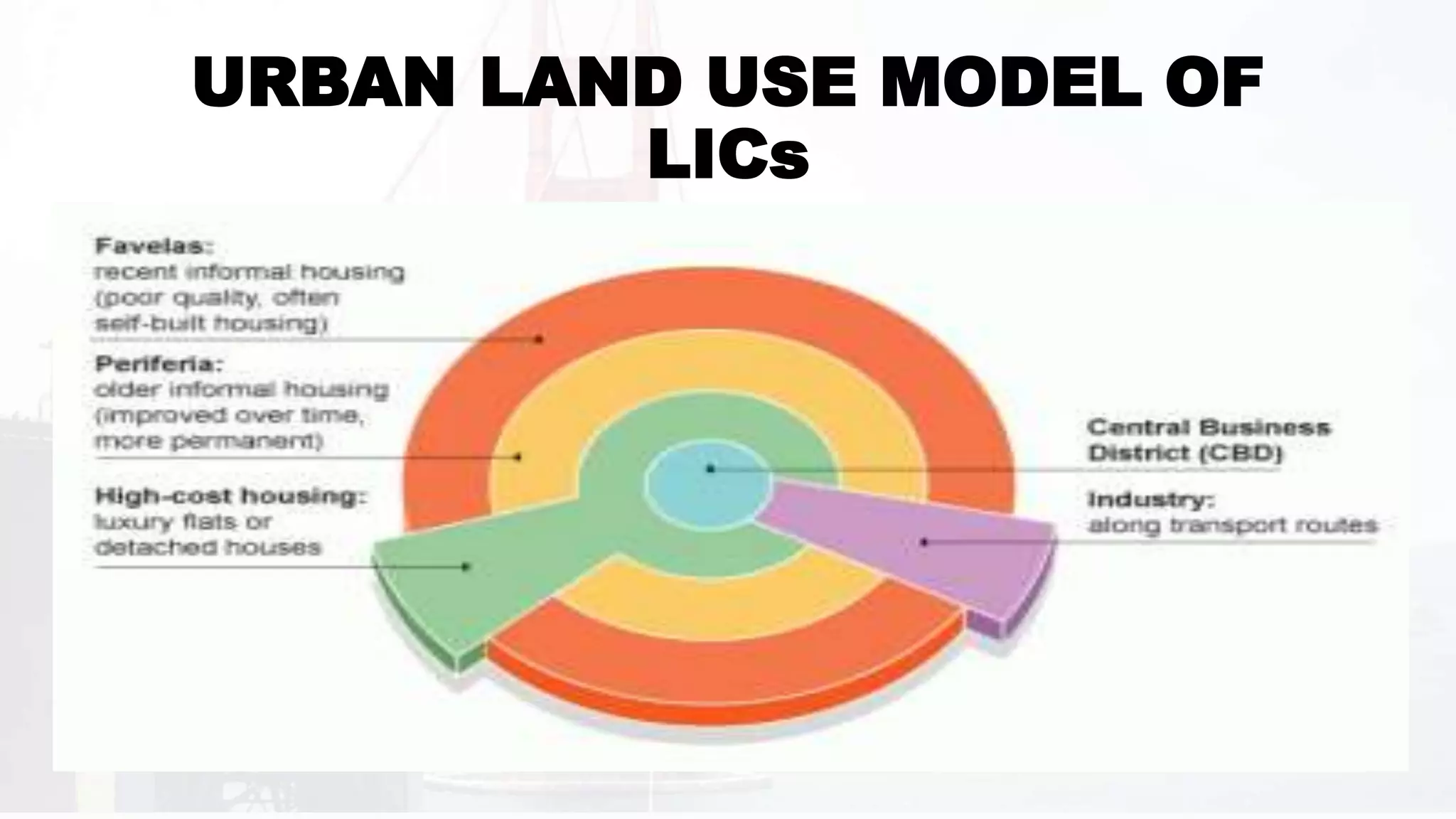
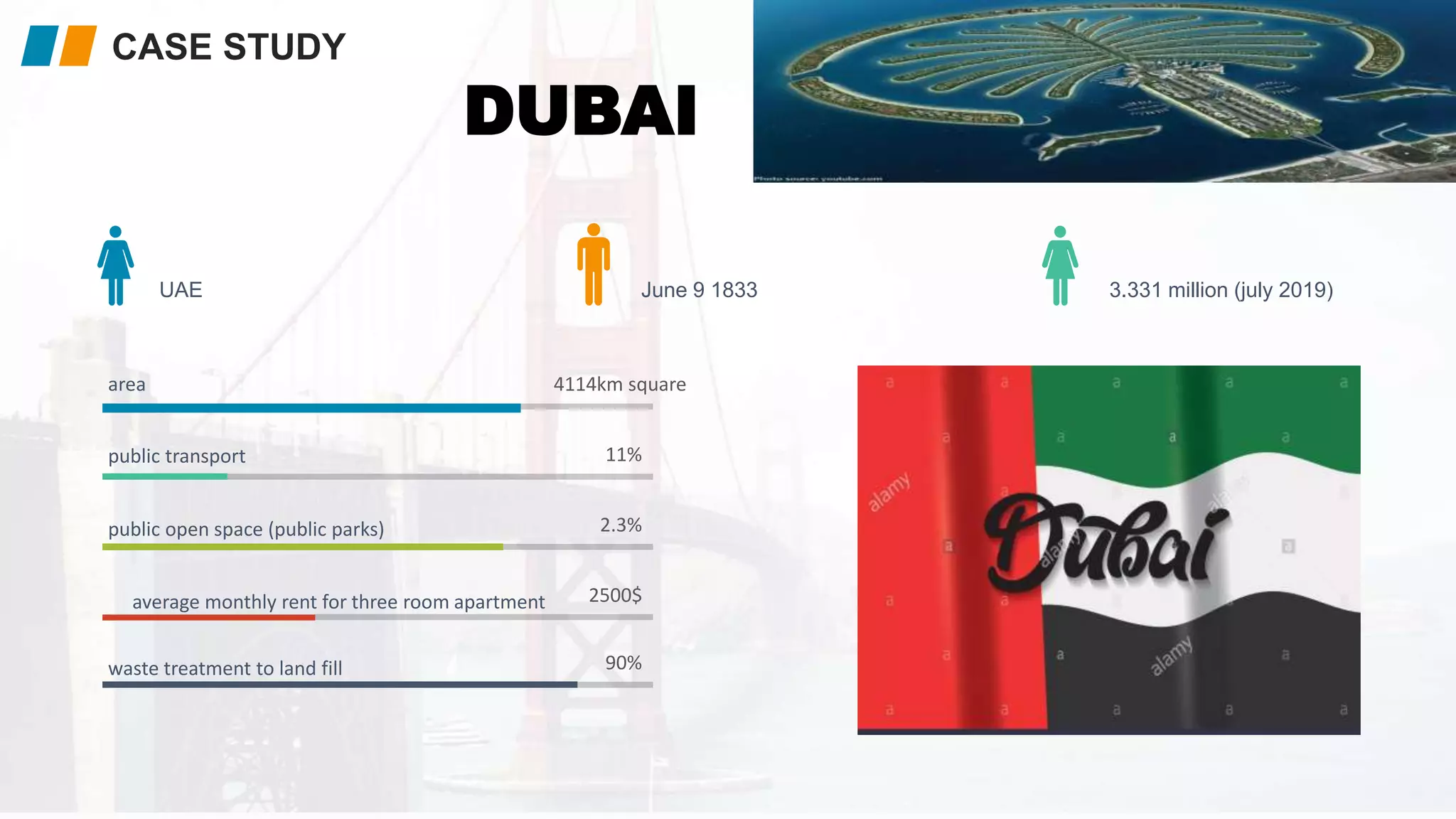
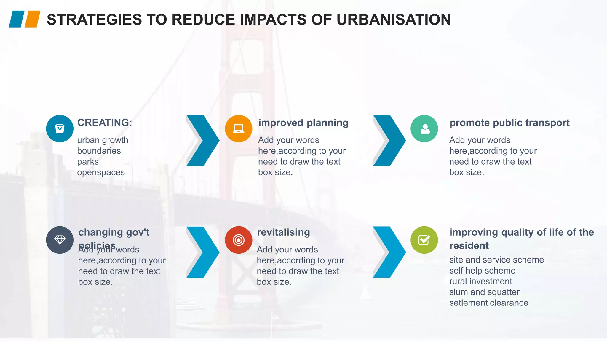
Levels, Patterns and Trends of Urbanization (World)ShreemoyeeSaha1
1. What is Urbanization?
2. Levels of Urbanization in the World
3. Patterns of Urbanization in the World : Demographic Changes, Economic Development, Consumption Pattern, Urban Footprint.
4. Patterns of Urbanization in Asia.
5. Trends of Urbanization in the World : Past, Recent and Future Trends.
6. Timeline of Urbanization in the World (1950- 2050)
7. Projected Urban and Rural Population.
8. Urbanization and Sustainability.
In context of India n comparing it with the world. The presentation defines these concepts with apt case studies from various countries and India as well..
Definition,meaning, scope,approach, and aim of urban-geographyKamrul Islam Karim
What is Urban Geography?
It can be considered a sub-discipline of the larger field of human geography with overlaps of content with that of Cultural Geography
Definition of Urban Geography.
Urban geography is the study of urban places with reference to their geographical environment.
Urban geography is the sub discipline of geography which concentrates on those parts of the Earth's surface that have a high concentration of buildings and infrastructure
.
It is that branch of science, which deals with the study of urban areas, in terms of concentration, infrastructure, economy, and environmental impacts.
Griffith Taylor- Urban Geography includes the site revolution pattern and classification of towns.
Dudley Stamp- Urban Geography is infecting the intensive study of town and their development in all their geographical aspects.
Meaning of an Urban Place
UN Demographic Year Book concludes: “There is no point in the continuum from large agglomerations to small clusters or scattered dwellings where urbanity disappears and rurality begins the division between urban and rural populations is necessarily arbitrary.”
A review of the problems of rural and urban centres as revealed by the Census Reports of various countries identifies a few bases for reckoning a place as urban.
Difference between rural and urban depends upon their nature of work – the former being engaged in agricultural operations and the latter in non-agricultural activities.
Criteria of an Urban Place
(1) A place designated by administrative status;
(2) A minimum population;
(3) A minimum population density;
(4) A concept of contiguity to include or exclude under suburban area or loosely scattered settlement;
(5) A proportion engaged in non-agricultural occupations; and
(6) A functional character.
Attributes of Urban Geography
Scope/nature/theme of Urban Geography
Methods or Approaches of Urban Places
Aim of urban geography
I’m professional presentation maker . These presentations are for sale for 20$ each, if required you can contact me on my gmail id bestpptmaker@gmail.com and you can also suggest me topics for your required presentations
Geographic Regions: by definition There three types of regions Formal regions are areas where a certain characteristic is found throughout. Functional regions consist of a central place and the surrounding places affected by it. Perceptual regions are defined by people’s attitudes and feelings about areas. 4.
Von thunen’s model of agricultural land useThe Urban Unit
This presentation is based on a agricultural land use model around the city. This is the theory of urban Geography it describe the agricultural pattern and how should the agricultural activities perform around the city. basically this Model was put forwarded before industrialization and when there was no roads networks and this Model is not applicable in real word but is gives great ideas for developing new towns and cities.
My presentation on Urban Sprawl for Sustainability Information Solutions weekly call.
Urban Sprawl is a situation where large stores, groups of houses, etc. are built in an area around a city that formerly had a few people living in it.
Indian Options for Managing Global Warming Through Ruralisation and Rationali...JIT KUMAR GUPTA
Paper looks at the option of adopting dual strategy , revolving round not only rationalising the development of cities but also promoting ruralisation through effective planning. New option will look at making villages more self-contained, self-sufficient, providing basic amenities and services besides generating employment for the rural inhabitants, creation of synergy between rural and urban settlements, rationalising planning, promoting accessibility, minimising mobility, planning for people not for vehicle and creating green built environment..
Chapter 2Chapter 2
Suburbs and
Suburban Sprawl
Community Redeveloped 2-1
Suburbs and Suburban Sprawl
Low-density development in a foothills suburb west of Denver,
Colorado. S. Buntin.
There is no more important community design problem than the redesign
and adaptation of the American suburb--the symbol and logos of
American affluence and technology and growth in the past forty years.
-- Sim Van der Ryn1
In the United States, more than one million acres of farmland land area. These are just some of the legacies of suburbanization
are lost annually to development. Between 1969 and 1983, since World War II.2
population in the U.S. grew 16 percent, while vehicle miles traveled Suburban communities demand careful evaluation because
grew 56 percent. Between 1970 and 1990, the Los Angeles many are unsustainable--they use resources without a mechanism for3
metropolitan area grew 45 percent in population, but 300 percent in adequately replenishing them; they are low-density in nature,
4
replacing wilderness with grass lawns, farmland with strip malls; they
give priority to the automobile over the pedestrian; they lack
economic and cultural diversity; and the list goes on. But to say that
many suburbs are unsustainable is not enough. What is unsustainable
about them? How did they get that way? What are the economic,
environmental, and social costs associated with a sprawl existence?
Why Focus on Suburban Communities?
Suburban communities warrant focus not because they are
suburbs per se, but because of their common postwar development
patterns. While central cities are generally high-density and often
based on a grid street pattern, and rural areas are very low density
and preserve--whether intended or not--agricultural and natural open
space, suburbs are often neither city nor country. And they are
Community Redeveloped 2-2
Suburbs and Suburban Sprawl
The Denver Post.
generally not a happy medium somewhere in between. Rather, central city decreases occurred from 1950 to 1990 in Cleveland;
postwar suburbs especially are low-density settlements comprised of Syracuse; Louisville, Kentucky; and Harrisburg, Pennsylvania.
Why are these statistics important? As later sections will
parks, and relatively large-lot residential subdivisions, predominantly
automobile-based.
Perhaps suburban trends would not be so significant if
suburbia wasn’t home to so many people. Today, over half of
America’s population lives in suburban settings. Moreover,5
suburban populations and geographic boundaries in many
metropolitan areas are growing at an alarming rate, especially in the
Western U.S. Here, thirteen states make up the most urbanized
region in America. The Seattle metropolitan area, for example, has6
grown from just over one million people in 1950, to nearly
three million in 1995. In that same time span, the Phoenix7
metropolitan area surged from 350,000 people to 2.5 million. And8 ...
Engineering management to urban development, particularly construction projects are
usually considered a ‘high risk job’ mostly because of, a lack of adequate government’s act
with necessary policies, environmental information, and urban construction experiences.
Similar construction projects may have very different risk characteristics of different
development regions in Nepal. It is difficult for a newcomer to identify new risks, in a new
environment and politically instable in the country. It is more difficult to assess these risks
and impact of relationships among them. On the one hand, ignoring these risks is
irresponsible and unrealistic decisions by the professionals. On the other hand, identifying
and assessing all the new risks and their relationships is a very complicated, time-consuming,
and expensive process. This process is possible for the majority of projects, especially when
there are adequate amounts of information, skilled technical team, and enough time. When
such a complex scenario faced the accessing and responding these vital risk factors in urban
development projects becomes extremely important. Engineering knowledge is the basic tools
to apply for drastic change in the country's infrastructures for urban development.
Urban Villages of Delhi: Case study Kotla MubarakpurJoel Michael
Documentation and analysis of surveys and mapping conducted in 3 urban villages of Delhi, namely, Kotla Mubarakpur, Mohammedpur and Hauz Khaz. Comparative analysis of their stages of urbanization and a proposal for Kotla Mubarakpur.
Comact City as an Option for Making Urban India more Sustainable and LivableJitKumarGupta1
Cities and towns remain critical in chartering and scripting the development trajectory of any community/nation. Structural transformation of the economy, sustaining high rates of economic growth and realization of economic potential is largely contingent on the efficacy and efficiency of urban settlements and rationalization of the process of urbanization. Well-managed, urbanization is known to fosters social and economic advancement and improved quality of life. However, cities are globally facing greater threat and challenges in terms of growing number of urban residents living in informal settlements , inadequate urban services, climate change; global warming; exclusion and rising inequality and poverty; rising insecurity; growing migration, rising global carbon emission. The current models and framework/approach to urbanization and urban planning remains highly unsustainable. Majority of Indian cities lack planning, capacity and preparedness to manage and counter effectively the challenges associated with rapid and massive urbanization. Accordingly, new agenda will be essential and critical to defined /effectively address the emerging challenges and take advantage of the opportunities offered by urbanization. The new urban agenda should promote human settlements that are planned, designed and managed to be environmentally sustainable; socially inclusive and economically productive. Compact city, as a role model of urban planning and development, offer enormous opportunities and options, to make cities more effective and efficient intense dense, efficient. Compact city is also known for its distinct quality of offering enormous opportunities to make cities more sustainable, socially interactive, walkable , cost-effective, land -efficient, productive, socially and environmentally, easy to develop/maintain. Accordingly, appropriate urban planning, development and management framework needs to be put in place and made operational on priority to make compact city model a distinct reality.
Strategies for Promoting Urban SustainabilityJIT KUMAR GUPTA
Paper is an attempt to define agenda for planning sustainable cities using different options of planning, transportation, green buildings, ruralisation etc
Paper is an attempt to look at the Indian urban settlements in terms of their planning, designing, travel, buildings etc, identify problems they have and options which can be leveraged to make them more effective, efficient, livable, productive and sustainable
POPULATION STRUCTURE, DISTRIBUTION AND DENSITYYonas Gemeda
This ppt lesson describe population structure with the help of pyramids through comparing developed and developing countries tell about patterns of population distribution and density
ROCKS and WEATHERING for As level GeographyYonas Gemeda
It describes the formation, types, and weathering of rocks, slope process, mass movement process, and types and the human impact on those weathering and slope process
POPULATION DYNAMICS FOR IGCSE CAMBRIDGEYonas Gemeda
this presentation will try to discuss population change through natural and manmade features and its cause and effects on the environment and its inhabitant
Hydrology and Fluvial Geo morphology for CAMBRIDGE AS level Yonas Gemeda
This power point lesson describes about the hydrology and rivers work in detail with different tools, which is more important for students and candidates of Cambridge Examination at AS level.
this power point talks about the causes, impacts and management strategies of volcanoes. it describe about the types of lava flow and types of volcanoes also,
this lesson discuess about causes of natural hazards, impacts of natural hazards, process of naural disaster and types of natural hazards based of different reasons
Operation “Blue Star” is the only event in the history of Independent India where the state went into war with its own people. Even after about 40 years it is not clear if it was culmination of states anger over people of the region, a political game of power or start of dictatorial chapter in the democratic setup.
The people of Punjab felt alienated from main stream due to denial of their just demands during a long democratic struggle since independence. As it happen all over the word, it led to militant struggle with great loss of lives of military, police and civilian personnel. Killing of Indira Gandhi and massacre of innocent Sikhs in Delhi and other India cities was also associated with this movement.
How to Make a Field invisible in Odoo 17Celine George
It is possible to hide or invisible some fields in odoo. Commonly using “invisible” attribute in the field definition to invisible the fields. This slide will show how to make a field invisible in odoo 17.
Unit 8 - Information and Communication Technology (Paper I).pdfThiyagu K
This slides describes the basic concepts of ICT, basics of Email, Emerging Technology and Digital Initiatives in Education. This presentations aligns with the UGC Paper I syllabus.
Read| The latest issue of The Challenger is here! We are thrilled to announce that our school paper has qualified for the NATIONAL SCHOOLS PRESS CONFERENCE (NSPC) 2024. Thank you for your unwavering support and trust. Dive into the stories that made us stand out!
The Art Pastor's Guide to Sabbath | Steve ThomasonSteve Thomason
What is the purpose of the Sabbath Law in the Torah. It is interesting to compare how the context of the law shifts from Exodus to Deuteronomy. Who gets to rest, and why?
Ethnobotany and Ethnopharmacology:
Ethnobotany in herbal drug evaluation,
Impact of Ethnobotany in traditional medicine,
New development in herbals,
Bio-prospecting tools for drug discovery,
Role of Ethnopharmacology in drug evaluation,
Reverse Pharmacology.
How to Split Bills in the Odoo 17 POS ModuleCeline George
Bills have a main role in point of sale procedure. It will help to track sales, handling payments and giving receipts to customers. Bill splitting also has an important role in POS. For example, If some friends come together for dinner and if they want to divide the bill then it is possible by POS bill splitting. This slide will show how to split bills in odoo 17 POS.
The Indian economy is classified into different sectors to simplify the analysis and understanding of economic activities. For Class 10, it's essential to grasp the sectors of the Indian economy, understand their characteristics, and recognize their importance. This guide will provide detailed notes on the Sectors of the Indian Economy Class 10, using specific long-tail keywords to enhance comprehension.
For more information, visit-www.vavaclasses.com
Welcome to TechSoup New Member Orientation and Q&A (May 2024).pdfTechSoup
In this webinar you will learn how your organization can access TechSoup's wide variety of product discount and donation programs. From hardware to software, we'll give you a tour of the tools available to help your nonprofit with productivity, collaboration, financial management, donor tracking, security, and more.
The French Revolution, which began in 1789, was a period of radical social and political upheaval in France. It marked the decline of absolute monarchies, the rise of secular and democratic republics, and the eventual rise of Napoleon Bonaparte. This revolutionary period is crucial in understanding the transition from feudalism to modernity in Europe.
For more information, visit-www.vavaclasses.com
How to Create Map Views in the Odoo 17 ERPCeline George
The map views are useful for providing a geographical representation of data. They allow users to visualize and analyze the data in a more intuitive manner.
3. describe and give resasons for the
characteristics of land use in urban areas
At the end of this unit, students will be
able to:
describe land use zones in countries at
different levels of economic development
explain the effect of change in land use and
urban growth in an urban area
demonstrate knowdge of case study of an
urban area, including changing land use and
urban sprawl.
LEARNING OUTCOMES
5. URBAN LAND USE MODELS
URBAN
BURG
ESS
LICs
model
comp
osite
HOYT
6. created in 1925, presented a city with a pattern
of concentric rings around a centere based on US
cities.
The characteristics of land use zones in urban areas
URBAN LAND USE
7. high cost of land
high rise building
few residence
Features of CBD
lack of open space
a transport focus
8. Add your title
HOYT SECTOR MODEL
came later 1939, when public transport had
developed in the cities of the USA.
in hoyt model land use developed along the
main transport routes running out from the CBD
10. Six Steps
Process
02
03
06
01
05 04
uses as ashopes, offices and
appartments
Gentrification
cheaper opion than
redevelopment.
advantages
convenient residential .
Creating pedestrianised zone.
RE GENERATION SCHEMES
redevelopment on brown field
sites.
gentrification
CHANGES IN LAND USE IN URBAN AREAS
11. 2017
2016
2015
2014
2013
2012
2011
2010
Trafic congestion
THE MAJOR PROBLEMS ARE
pollution
causes
shortage of
housing and
overcrowding
unemployment
deprivation
PROBLEMS OF URBAN AREAS
inadequate road
infrastructure
lack of private and
public housing
rural urban migration
urban economy failing
solution
attracting new
bussiness
planned urban
housing expansion
increase provision
of urban transport
12. 4114km square
11%
2.3%
2500$
90%
area
UAE June 9 1833 3.331 million (july 2019)
public transport
public open space (public parks)
average monthly rent for three room apartment
waste treatment to land fill
CASE STUDY
DUBAI
14. RAPID URBAN GROWTH
A CASE STUDY
RIO DE JANEIRO,
BRAZIL
IMPACTS OF URBAN GROWTH
EXAM STYLE
REVISION
QUESTIONS
CONTENTS
STRATEGIES TO REDUCE THE
NEGATIVE IMPACTS OF
URBANISATION
15. the processby which an increasing proportion of peoplelive in towns and cities instead of the
countryside
URBANISATION
cities with 10 millions inhabitants or more
mega cities
the decline in population as a result of
migration or a decline in birth rates as young
people move away
rural depopulation
KEY TERMS
16. asia 53%..Europe 14%.... South
America 13%....
coverage by region
2016 to 2030 will be absorbed
by urban areas, accounting for
a growth of about 1.1 billion
people in this period.
UN projection
1950 - 746mi
2017 - 4bi
urban population of the world
RAPID URBAN GROWTH
17. due to vast numbers of people involved in this
growth, careful urban planning will be needed in
urban settlements of all size.
WHY?
cities are important in the development process of
mocountries and in the reduction of poverty in both
urban and rural areas
cities
urban living is often associated with higher levels of
litracy and education, better health, greater access
to social service, and enhanced opportunities for
cultural and political participation.
cities and services
THE NEED FOR URBAN PLANNING
18. push factors
shortage of alternative jobs
high infant mortality in many rural
areas
natural disaster
lack of infrastructure
rural depopulation
more infrastructure and services
successful migrants
pull factors
Add your words here,according to
your need to draw the text box
size.
Add your title
in some unplanned or ineadequately
managed cities, urban expansion has led
to rapid urban sprawl, pollution and
environmental degradation, together with
unsustainable production and levels of
consumption
IMPLICATIONS
IMPLICATION OF REPID AND UNPLANNED URBAN GROWTH
22. overcrowding house
devastating fires
overpopulsted
competition for employment
poor sanitation
challenges
poor access to education
lack of space in settlements
lack of infrastructure
challanges
an area of makeshift housing that
usually develops on unfavorable
sites in and around MICs and LICs
city
they are also known as shanty
towns or bustees
MEANING
SQUATTER SETTLEMENTS
23. urban growth
boundaries
parks
openspaces
CREATING:
Add your words
here,according to your
need to draw the text
box size.
improved planning
Add your words
here,according to your
need to draw the text
box size.
promote public transport
site and service scheme
self help scheme
rural investment
slum and squatter
setlement clearance
improving quality of life of the
resident
Add your words
here,according to your
need to draw the text
box size.
revitalising
Add your words
here,according to your
need to draw the text
box size.
changing gov't
policies
STRATEGIES TO REDUCE IMPACTS OF URBANISATION
24. SOLUTIONS
SCIENTIFIC SOLUTIONS
YOUT OWN SOLUTION
THE REAL CHALLENGES
WHAT IS THE MAJOR PROBLEMS OF
CURTIBA RELATED TO URBAN GROWTH
CHARACTERS
CASE STUDIES CURTIBA, BRAZIL
26. QUESTIONS
LEADS
YOU
TO
SUCCESS
EXAM STYLE QUESTIONS
most large urban areas have made attempts to solve the problem of
traffic congestion faced by the people who live there. for Curtiba
and Rio de janeiro describe how attempts have been made to solve
the problem
in the cities of the developing world, a large
proportion may live in slums (sqr setlments).
what are the possible reasons for this?
question 3
using examples that you have studided,
explain the strategies that caan be used to
reduce the negative impacts of urbanisation
question 2
question 1
ANSWER THE FOLLOWING QUESTIONS.