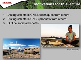
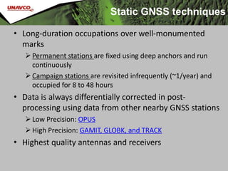
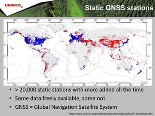
Static GNSS
Vince Cronin (Baylor University) & Shelley Olds (UNAVCO)
Revisions by Beth Pratt-Sitaula (UNAVCO) and Benjamin Crosby (ISU)
Version June 8, 2017
Motivations for this lecture
1. Distinguish static GNSS techniques from others
2. Distinguish static GNSS products from others
3. Outline societal benefits
(Image: Ben Crosby)
• Long-duration occupations over well-monumented
marks
Permanent stations are fixed using deep anchors and run
continuously
Campaign stations are revisited infrequently (~1/year) and
occupied for 8 to 48 hours
• Data is always differentially corrected in post-
processing using data from other nearby GNSS stations
Low Precision: OPUS
High Precision: GAMIT, GLOBK, and TRACK
• Highest quality antennas and receivers
Static GNSS techniques
Static GNSS stations
• > 20,000 static stations with more added all the time
• Some data freely available, some not
• GNSS = Global Navigation Satellite System
https://www.unavco.org/science/snapshots/solid-earth/2015/kreemer.html
Plate Boundary Observatory (PBO)
PBO involves installation, operation, and maintenance
of >1100 continuously operating high-precision GPS
stations (plus >170 other instruments: strainmeters,
borehole seismometers, and tiltmeters)
http://www.unavco.org/instrumentation/networks/status/pbo
What is possible with static
GNSS products?
• Spatial positions within a few millimeters.
Requires intensive, high-precision processing
• Thus . . . can track very small changes
Plate motions
Deformation due to hydrology
 Snow or reservoir loading
 Groundwater withdraw
Deformation due to volcanic activity
 Pre-eruption doming
 Caldera collapse
Earthquake motions
 Slow slip and coseismic deformation
Two PBO stations in
California
• Twenty-nine
Palms,(BEMT)
• Mission Viejo (SBCC)
Where is that chunk of crust
going?
• Example: using GPS velocities to understand
plate motions
http://www.unavco.org/instrumentation/networks/status/pbo/overview/SBCC
• Station position over time
North–South
East–West
Up–Down
GPS time-series data
• From the changing
position, velocity can be
calculated using slope
(rise-over-run)
http://www.unavco.org/instrumentation/netwo
rks/status/pbo/overview/SBCC
GPS time-series data
19 years
510 mm
north
26.8 mm/yr
475 mm
west
25.0 mm/yr
~0.4 mm/yr
~8 mm down
19 years
510 mm
north
26.8 mm/yr
475 mm
west
25.0 mm/yr
~0.4 mm/yr
~8 mm down
PBO also supplies “detrended” data with the average velocity subtracted out to
observe other phenomena. In that case official velocity is given.
Detrended GPS time data
What is a site’s 3D speed?
Using the Pythagorean Theorem (high school math...),
Speed = (27.8)2 + (25.7)2 + (1.3)2 = 37.9 mm/yr
Using the horizontal components of velocity,
and a bit of high school trigonometry…
What compass direction is
the site moving?
42.8°west of north
or
317.2°azimuth
θ = tan-1(25.7/27.8) = 42.8°
θ
27.8 mm/yr
25.7 mm/yr
North
West
Map view of velocity
20 mm/yr
Two different velocities
Same process yields much slower velocity at BEMT
20 mm/yr
Why the difference?
San Andreas Fault!
20 mm/yr
Reference Frames
All velocities are
RELATIVE to a given
reference frame
• Velocities
compared to
International
Terrestrial
Reference Frame
2008 (IGS08 is GPS
reference frame
name)
• Hot spot
constellation as
“stable”
Reference frames
All velocities are
RELATIVE to a given
reference frame
• Velocities
compared to stable
North America
(called NAM08
reference frame)
• Eastern North
America as “stable”
Societal benefits
• Static GNSS data are used in a wide variety of surface
deformation applications.
• Some are directly supporting human needs
Tracking hazardous features such as landslides, faults, or
volcanos
Tracking changes in water resources
• Some are indirectly providing insight into the way the
earth works
Plate motions
Discovering new faults
• Some static, continuous sites are used for corrections
to other GNSS data, aiding industry.
Societal value of
GNSS-enabled research
• Most people use it for location and navigation,
but how do earth scientists use GNSS?
Think-Pair-Share discussion
How do earth scientists use GNSS?
 List as many applications as you can.
How do these uses benefit society?
 Categorize each as a direct or indirect benefit.
– Direct benefits are immediate and improve lives
– Indirect benefits help humans, but are a few steps removed
Societal value of
GNSS-enabled research
• Most people use it for location and navigation,
but how do Earth Scientists use GNSS?
How do earth scientists use GNSS?
 (type student applications here)
How do these uses benefit society?
 Direct
– (type student benefits here)
 Indirect
– (type student benefits here)

Unit 3 Static GNSS Lecture

  • 1.
    Static GNSS Vince Cronin(Baylor University) & Shelley Olds (UNAVCO) Revisions by Beth Pratt-Sitaula (UNAVCO) and Benjamin Crosby (ISU) Version June 8, 2017
  • 2.
    Motivations for thislecture 1. Distinguish static GNSS techniques from others 2. Distinguish static GNSS products from others 3. Outline societal benefits (Image: Ben Crosby)
  • 3.
    • Long-duration occupationsover well-monumented marks Permanent stations are fixed using deep anchors and run continuously Campaign stations are revisited infrequently (~1/year) and occupied for 8 to 48 hours • Data is always differentially corrected in post- processing using data from other nearby GNSS stations Low Precision: OPUS High Precision: GAMIT, GLOBK, and TRACK • Highest quality antennas and receivers Static GNSS techniques
  • 4.
    Static GNSS stations •> 20,000 static stations with more added all the time • Some data freely available, some not • GNSS = Global Navigation Satellite System https://www.unavco.org/science/snapshots/solid-earth/2015/kreemer.html
  • 5.
    Plate Boundary Observatory(PBO) PBO involves installation, operation, and maintenance of >1100 continuously operating high-precision GPS stations (plus >170 other instruments: strainmeters, borehole seismometers, and tiltmeters) http://www.unavco.org/instrumentation/networks/status/pbo
  • 6.
    What is possiblewith static GNSS products? • Spatial positions within a few millimeters. Requires intensive, high-precision processing • Thus . . . can track very small changes Plate motions Deformation due to hydrology  Snow or reservoir loading  Groundwater withdraw Deformation due to volcanic activity  Pre-eruption doming  Caldera collapse Earthquake motions  Slow slip and coseismic deformation
  • 7.
    Two PBO stationsin California • Twenty-nine Palms,(BEMT) • Mission Viejo (SBCC) Where is that chunk of crust going? • Example: using GPS velocities to understand plate motions
  • 8.
    http://www.unavco.org/instrumentation/networks/status/pbo/overview/SBCC • Station positionover time North–South East–West Up–Down GPS time-series data
  • 9.
    • From thechanging position, velocity can be calculated using slope (rise-over-run) http://www.unavco.org/instrumentation/netwo rks/status/pbo/overview/SBCC GPS time-series data 19 years 510 mm north 26.8 mm/yr 475 mm west 25.0 mm/yr ~0.4 mm/yr ~8 mm down
  • 10.
    19 years 510 mm north 26.8mm/yr 475 mm west 25.0 mm/yr ~0.4 mm/yr ~8 mm down PBO also supplies “detrended” data with the average velocity subtracted out to observe other phenomena. In that case official velocity is given. Detrended GPS time data
  • 11.
    What is asite’s 3D speed? Using the Pythagorean Theorem (high school math...), Speed = (27.8)2 + (25.7)2 + (1.3)2 = 37.9 mm/yr
  • 12.
    Using the horizontalcomponents of velocity, and a bit of high school trigonometry… What compass direction is the site moving? 42.8°west of north or 317.2°azimuth θ = tan-1(25.7/27.8) = 42.8° θ 27.8 mm/yr 25.7 mm/yr North West
  • 13.
    Map view ofvelocity 20 mm/yr
  • 14.
    Two different velocities Sameprocess yields much slower velocity at BEMT 20 mm/yr Why the difference?
  • 15.
  • 16.
    Reference Frames All velocitiesare RELATIVE to a given reference frame • Velocities compared to International Terrestrial Reference Frame 2008 (IGS08 is GPS reference frame name) • Hot spot constellation as “stable”
  • 17.
    Reference frames All velocitiesare RELATIVE to a given reference frame • Velocities compared to stable North America (called NAM08 reference frame) • Eastern North America as “stable”
  • 18.
    Societal benefits • StaticGNSS data are used in a wide variety of surface deformation applications. • Some are directly supporting human needs Tracking hazardous features such as landslides, faults, or volcanos Tracking changes in water resources • Some are indirectly providing insight into the way the earth works Plate motions Discovering new faults • Some static, continuous sites are used for corrections to other GNSS data, aiding industry.
  • 19.
    Societal value of GNSS-enabledresearch • Most people use it for location and navigation, but how do earth scientists use GNSS? Think-Pair-Share discussion How do earth scientists use GNSS?  List as many applications as you can. How do these uses benefit society?  Categorize each as a direct or indirect benefit. – Direct benefits are immediate and improve lives – Indirect benefits help humans, but are a few steps removed
  • 20.
    Societal value of GNSS-enabledresearch • Most people use it for location and navigation, but how do Earth Scientists use GNSS? How do earth scientists use GNSS?  (type student applications here) How do these uses benefit society?  Direct – (type student benefits here)  Indirect – (type student benefits here)

Editor's Notes

  • #2 This slideshow goes over the basics of how the global positioning system (GPS) works. GPS is the USA-based component of the GNSS (global navigation satellite system), which includes many more satellites than just the ones in orbit by the USA. Questions or comments please contact or education AT unavco.org
  • #3 Images: UNAVCO (http://www.unavco.org/projects/major-projects/pbo/pbo.html) and Crosby.
  • #5 GNSS refers to the entire global network using this basic type of technology (global navigation satellite system) Technically, GPS, is the USA system and only refers to the satellites within our country purview, but GNSS is not yet as well recognized a term as GPS.
  • #6 Plate Boundary Observatory (PBO) is a major component of the large geophysics initiative EarthScope. It is run by UNAVCO, a nonprofit university-governed consortium dedicated to providing geodetic support to the research and educational communities. The PBO GPS stations are located throughout the United States, territories, and a few other places around the world, but the highest concentration of stations is in the actively deforming western USA and southern Alaska. PBO is the biggest GPS network in the USA and one of the biggest (if not the biggest) in the world. All data from PBO (raw and processed) is freely available through a variety of data portals maintained by UNAVCO (http://www.unavco.org/data/data.html, see GPS/GNSS). It is generally the easiest GPS data to get started using, especially with students.
  • #8 Southern California has numerous PBO stations, but let’s look at just two stations to see what we can learn from different velocities. Background image from Google Maps. Labels from UNAVCO http://www.unavco.org/education/resources/data-for-educators/data-for-educators.html
  • #9 A variety of data products are available for each PBO station (http://www.unavco.org/instrumentation/networks/status/pbo/gps), but the most basic processed data is the station position over time = “time series.” The position is broken into the three orthogonal directions and set to an arbitrary zero datum. The most common reference frame for PBO data is North American 2008 (NAM08) reference grame, which assumes that the eastern North America is not moving and all the motion in western North America is shown relative to this fixed stable east. For more on reference frames: https://www.unavco.org/software/visualization/GPS-Velocity-Viewer/GPS-Velocity-Viewer-frames.html Vertical data are always much less accurate because of the angle to the satellite (if we could only put satellites below the surface of the Earth, vertical accuracy would improve).
  • #11 Note that the velocity calculated by PBO from all the data points is quite similar to what we determined here in a back-of-envelope visual calculation.
  • #14 Background image from Google Maps. Labels from UNAVCO http://www.unavco.org/education/resources/data-for-educators/data-for-educators.html
  • #15 Ask your students to think about WHY there might be this great different in velocity between two nearby stations?
  • #16 The San Andreas Fault lies between these two stations so of course SBCC is moving much more quickly than BEMT
  • #17 Compared to plate motions, hot spots are much more fixed, so a global reference frame has been defined in comparison to that hot spot constellation. Image from UNAVCO
  • #18 More useful for most typical applications is to consider a local reference frame, where movement in a deforming plate boundary is compared to the more stable, less-deforming region. Image from UNAVCO For more on reference frames see: https://www.unavco.org/software/visualization/GPS-Velocity-Viewer/GPS-Velocity-Viewer-frames.html
  • #23 GPS depends on extremely accurate time-keeping, so the very best clocks must be used.