This document contains information from a traffic study conducted on a road connecting various departments at a university. The study found that:
1) The 85th percentile speed on the road was higher than the posted speed limit of 25 kmph, especially in the straight section in front of the Biotechnology department.
2) Bicycles made up the majority of vehicles on the road, with generally low traffic during the day.
3) Speed breakers were not fully effective in reducing speeds to the limit, and adding another breaker in front of the Biotechnology department was recommended.
This document summarizes a talk on estimating the effectiveness of speed cameras. It discusses how sites with high accident rates are selected for remedial treatments like speed cameras. However, simply comparing accident rates before and after can overestimate effectiveness due to regression to the mean. The talk presents methods to account for regression to the mean and trends when evaluating speed camera effectiveness, using empirical Bayes and analyses of transparency data from camera partnerships. Allowing for these factors suggests the true safety benefit of cameras may be lower than initial estimates based only on before-after comparisons.
Spot speed studies are used to determine the speed
distribution of a traffic stream at a specific location. I The data gathered in spot speed studies are used to determine vehicle speed percentiles, which are useful in making many speed-related decisions
(1) The document reports on a study to determine the spot speed of vehicles on a section of the Maitighar-Tinkune Road in Nepal.
(2) Data on vehicle speeds was collected manually over the 54m section, with over 290 vehicles observed.
(3) Analysis found the 85th percentile speed (the speed at which 85% of vehicles travel at or below) to be 44kmph, while the 50th percentile speed was 37kmph.
Risk based, multi objective vehicle routing problem for hazardous materials: ...Valerio Cuneo
The paper analyses a practical case of study related to the distribution of fuels for the Total Erg Oil Company to the service stations located in the Province of Rome (Italy).
The problem is formulated as a capacitated vehicle routing problem with time windows, where several heuristic procedures have been tested, considering both static and dynamic travel times. With respect to the standard operational costs used typically, a multivariable objective function has been proposed which takes into account also a new risk index.
This document discusses different types of traffic speed studies including spot speed studies, travel time studies, and speed delay studies. It then provides details on specific objectives, scope, and methods of conducting traffic speed studies. The document presents data from a traffic speed study conducted at two intersections in Dhaka, including spot speeds, histograms, frequency and cumulative frequency curves. It analyzes the data to determine weighted average speed, pace, modal speed and compares time mean speed to space mean speed based on the Wardrop relationship. Finally, it calculates delay time, value of travel time and vehicle operating costs.
GreenSwirl: Combining Traffic Signal Control and Route Guidance for Reducing ...Naoki Shibata
Jiaxing Xu, Weihua Sun, Naoki Shibata and Minoru Ito : "GreenSwirl: Combining Traffic Signal Control and Route Guidance for Reducing Traffic Congestion," in Proc. of IEEE Vehicular Networking Conference 2014 (IEEE VNC 2014), pp. 179-186.
Serious traffic congestion is a major social problem in large cities. Inefficient setting of traffic signal cycles, especially, is one of the main causes of congestion. GreenWave is a method for controlling traffic signals which allows one-way traffic to pass through a series of intersections without being stopped by a red light. GreenWave was tested in several cities around the world, but the results were not satisfactory. Two of the problems with GreenWave are that it still stops the crossing traffic, and it forms congestion in the traffic turning into or out of the crossing streets. To solve these problems, we propose a method of controlling traffic signals, GreenSwirl, in combination with a route guidance method, GreenDrive. GreenSwirl controls traffic signals to enable a smooth flow of traffic through signals times to turn green in succession and through non-stop circular routes through the city. The GreenWave technology is extended thereby. We also use navigation systems to optimize the overall control of the city's traffic. We did a simulation using the traffic simulator SUMO and the road network of Manhattan Island in New York. We confirmed that our method shortens the average travel time by 10%-60%, even when not all cars on the road are equipped to use this system.
2016 D-STOP Symposium ("Smart Cities") session by CTR's Stephen Boyles. Get symposium details: http://ctr.utexas.edu/research/d-stop/education/annual-symposium/
Wherecamp Navigation Conference 2015 - The unintelligent swarmWhereCampBerlin
1) The document discusses how traffic routing oscillations can occur when a high percentage of drivers receive real-time traffic information from the same provider and choose routes based on that information.
2) Microsimulations of a worst-case scenario showed that when all drivers on the network received the same estimated travel times, it led to unstable routing patterns as traffic levels on different roads continually fluctuated.
3) To overcome these instabilities, the document recommends using stochastic route choice models that incorporate an element of uncertainty into individual routing decisions, helping to distribute traffic more evenly across the network.
This document provides information about a study conducted on the Mevad Toll Plaza located on the Mehsana-Ahmedabad Highway in Gujarat, India. The study involved collecting classified volume count data, service time data for different vehicle types, and conducting a user survey. The data was analyzed to determine peak traffic hours and the average service times. It was found that the average service time at the manual toll plaza was around 25 seconds per vehicle, much higher than the 4-5 seconds per vehicle achieved at electronic toll collection plazas. The results of the study can be used to identify opportunities to reduce congestion and delays at the toll plaza.
This document summarizes a study of saturation flow rates and delay at a signalized intersection in Dehiwala, Sri Lanka. Field observations were made between 2:55-3:30pm on August 14, 2017. The mean saturation flow rate was calculated as 1460.5 vehicles/hour. The intersection control delay per vehicle was calculated as 5.677 seconds, resulting in a level of service B. Several limitations of the study are noted, including disturbances from pedestrians and issues with video clarity. Proposed measures are given to address the limitations and improve traffic flow, such as upgrading the signal system and separating pedestrian and vehicle flows.
The document summarizes a study conducted by the Westchester County Department of Public Works to optimize traffic signal timing across 28 municipalities through signal retiming. Signal retiming aims to improve traffic flow and reduce emissions by analyzing existing traffic patterns and signal infrastructure. The study collected data from over 600 intersections, analyzed current conditions and potential timing/coordination improvements. It estimated user delay cost savings of $108 million could result from improved signal timing without upgrades. Municipalities then applied for funding to implement recommended timing plans and signal upgrades identified in the study.
Group 18 designed three traffic signal systems for intersections along Speedway Blvd near the University of Arizona. Their recommended design uses cameras to detect queue sizes up to three cars and adjusts green light times accordingly. They tested the designs in a Simulink traffic model, calculating average delays and queues at each intersection. Design 2 performed best by minimizing delays while keeping queues low. The group met weekly from November to December to develop the traffic models, analyze results, and write their final report.
This document provides information for analyzing a multi-lane highway including general site details, traffic volume inputs, speed inputs, and operational and design level of service calculations. It analyzes a 1.6 km highway section with a 6% grade, calculates adjusted traffic volumes and free-flow speed based on lane width and access points, and determines the highway requires 1.7 lanes to operate at level of service B under projected peak hour traffic volumes of 1000 vehicles per hour.
The document analyzes the impact of converging runway operations (CRO) at George Bush Intercontinental Airport in Houston (IAH). It finds that CRO reduced airport resilience by decreasing the maximum arrival rate by 3 flights per hour and increasing average taxi-in time from 6.5 to 9.1 minutes. While CRO improves safety, its current implementation at IAH reduced operational efficiency and capacity. The presentation recommends adjusting CRO to better synchronize arrivals on parallel runways in order to recover lost capacity without compromising safety.
This document summarizes a study analyzing the impacts of connected vehicle (CV) technology on managed lane (ML) usage and traffic performance. The study used microsimulation to model a 10-mile highway segment with MLs under different CV market penetration rates. Key findings included a decrease in ML usage as more vehicles were connected, as drivers perceived greater travel time savings than actual savings. Overall mobility was similar for lower CV rates but saw increased delays over 10%. Revenue losses for the ML operator increased substantially with higher CV adoption rates.
This document analyzes traffic data collected from two locations: Rassel Square to Panthopath and Panthopath to Rassel Square. The analysis includes:
1. Vehicle composition - Light vehicles make up 49% of traffic, while motorcycles and auto rickshaws each make up 10%.
2. Directional distribution - Traffic flows vary by time of day and direction. More vehicles travel from Panthopath to Rassel Square compared to the opposite direction.
3. Average daily traffic (ADT) and annual average daily traffic (AADT) - ADT and AADT are calculated for each location to understand typical and annual traffic volumes.
(Slides) A Technique for Information Sharing using Inter-Vehicle Communicatio...Naoki Shibata
Shinkawa, T., Terauchi, T., Kitani, T., Shibata, N., Yasumoto, K., Ito, M. and Higashino, T.: A Technique for Information Sharing using Inter-Vehicle Communication with Message Ferrying, International Workshop on Future Mobile and Ubiquitous Information Technologies (FMUIT'06).
http://mimi.naist.jp/~yasumoto/papers/FMUIT2006-shinkawa.pdf
In this paper, we propose a method to realize traffic information
sharing among cars using inter-vehicle communication.
When traffic information on a target area is retained
by ordinary cars near the area, the information may be lost
when the density of cars becomes low. In our method, we
use the message ferrying technique together with the neighboring
broadcast to mitigate this problem. We use buses
which travel through regular routes as ferries. We let buses
maintain the traffic information statistics in each area received
from its neighboring cars. We implemented the proposed
system, and conducted performance evaluation using
traffic simulator NETSTREAM. As a result, we have confirmed
that the proposed method can achieve better performance
than using only neighboring broadcast.
This document discusses how analytic reporting can identify issues with paratransit service and help solve them. It provides two case studies:
1) A system had low on-time performance (OTP) in afternoons. Shifting run start times and adjusting lengths increased afternoon capacity and improved OTP to 94.72%. Productivity increased 3.6-5.4%.
2) Analysis found runs didn't match demand. Optimizing runs reduced vehicle hours by 1.1% and driver hours by 1.3%, while maintaining service. Shifting low-demand trips to non-dedicated providers produced the most savings.
How Analytic Reporting Can Identify and Solve Paratransit Service ShortcomingsTSSParatransit
This document discusses how analytic reporting can identify opportunities to improve paratransit service quality and efficiency. It provides two case studies:
1) A system was struggling with low on-time performance in afternoons. Shifting run start times and adjusting lengths increased afternoon capacity and improved on-time rates from 84.9% to 94.7%. Productivity increased 3.6-5.4%.
2) A system's run structure did not match demand. Optimizing reduced hours/vehicles 1.1-1.3% while maintaining service. Diverting trips to non-dedicated providers during low-demand times produced the most savings.
3) Analytic tools can evaluate strategies like
Driving alone versus riding together - How shared autonomous vehicles can cha...JumpingJaq
This document discusses how shared autonomous vehicles could change transportation by reducing private car ownership. It covers topics like adoption rates, modeling approaches, impacts on travel behavior and transportation networks, effects of shared autonomous taxis, and implications for infrastructure planning. The key points are that shared autonomous vehicles could increase mobility access, reduce transportation costs through mobility-as-a-service models, and optimize road usage through higher vehicle occupancy.
This document discusses calibration of saturation flow rates for hybrid traffic simulation using Aimsun. It finds that default Aimsun parameters do not produce typical saturation flow rates or comparability between micro and meso simulations. Reaction times and turn speeds impact micro simulation saturation flow, while reaction times, jam density, and turn speeds impact meso simulation saturation flow. The document recommends calibration parameter values for micro and meso as a starting point and notes other factors like lane changing that require consideration.
Nissan has a triple-layered approach for promoting eco-friendly driving called ECO Telematics, which includes dynamic route guidance (DRG), eco management systems (EMS), and electric vehicles. DRG uses vehicle-infrastructure cooperation and probe data to provide real-time traffic information and the most fuel efficient routes. EMS provides drivers with feedback on their driving efficiency and tips to improve. Electric vehicles such as the Nissan Leaf further reduce emissions. Nissan's studies show DRG can increase average speeds by 25% and reduce CO2 emissions by 17%, while EMS has improved fuel efficiency by up to 18% in tests.
NISSAN has developed a triple-layered approach for eco-friendly driving called ECO Telematics, which includes dynamic route guidance (DRG), eco management systems (EMS), and electric vehicles. DRG uses real-time traffic information to provide the most fuel efficient routes, reducing travel time and emissions. EMS provides drivers with feedback on their driving efficiency to encourage eco-driving habits. NISSAN is also developing electric vehicles like the LEAF to further reduce emissions. Field tests show these systems can increase speeds by 25% and lower CO2 emissions by up to 17%.
This document provides a summary of the calibration of a VISSIM microsimulation model of the I-390 interchange with Routes 15A and 15. The calibration process ensured the base model accurately replicated real-world traffic conditions. Key aspects of the calibration included determining the appropriate seeding interval, number of simulation runs, calibration limits, adjustments to driver behaviors, and validating traffic volumes, speeds and visual characteristics matched field observations. The calibrated model falls within calibration limits and is considered an accurate representation of existing traffic conditions in the study area.
The world of transportation is radically changing. It is an industry with immense technological challenges, most of which are AI related. In the current paste and major active industry players, it will become unrecognisable in following years.
In this talk I aim to cover the different fields that it includes, data science related problems that it poses, and current state of the art solutions.
The focus of this talk will be smart cities, which multiple teams @Google work on, including mine and myself.
I will present my own work, including hotspot analysis, trajectory tracking (using a novel clustering method) using GPS and beacon data (patent pending), vehicle identification (classification and clustering), ETA and routing optimisation and personalisation (regression and ranking), drivers and riders matching (ranking and classification) and city planning.
I will also cover but not focus other smart city topics research and solutions by my counterparts on other Google teams and in Uber like autonomous vehicles (not a focus here, it is already too popular and crowded and appears in too many talks), fleet coordination (in a multi agent system), load distribution (reinforcement based), and vehicle syncing.
I will describe problems and solutions including the algorithm / model that is most currently used in the industry to solve such problems. On specific example, which I have personally researched I will go into more detail, including research phases, algorithm inner working and experiment results (usually A/B testing) on real user data.
This talk will give the audience an understanding of the tremendous challenges faced when trying to improve the state of transportation, and how we solve and plan on solving them to make the world a better place. It will also give participants a rare glimpse to some of Google's and Waze's ideas, algorithm, research methodologies and future plans for global transportation.
From personal experience of giving talks on transportation / Waze algorithms (never this one before) I have learnt that this is an "emotional" subject for many people, therefore very exciting to audience and full of questions.
Note that this talk is very different from the one presented last year which was covering multiple fields Waze operates on (e.g. Ads, usage, conversion, behavioural analytics, etc.). This talk would focus only transportation, current state and future which focus on how data science is crucial and the leading field in solving many of these problems.
Geotab can be used to improve healthcare businesses in several key areas: [1] Patient transportation safety through monitoring driver behavior and vehicle data; [2] Improving productivity by optimizing patient routing and monitoring employee time; [3] Reducing fleet costs by managing fuel usage, maintenance, and asset utilization. Geotab integrates with other systems to optimize dispatching, provide proof of visits, and ensure regulatory compliance.
Inaugural Professorial lecture by Simon Shepherd, Professor of Choice Modelling & Policy Design. Institute for Transport Studies, University of Leeds, 9th September 2014.
For audio recording see: www.its.leeds.ac.uk/about/events/inaugural-lectures2014
www.its.leeds.ac.uk/people/s.shepherd
www.its.leeds.ac.uk/research/themes/dynamicmodelling
Hk icth2016 14th_june2016_htw_website versionHaneen Khreis
This document outlines the multi-step process for estimating human exposure to traffic-related air pollution and assessing its health effects. The steps include: 1) determining traffic activity using transport models; 2) determining vehicle proportions; 3) applying emission factors to calculate pollutant loads; 4) using dispersion models to simulate pollutant dispersion; 5) assigning exposures to locations; and 6) assessing associations between exposures and health outcomes. However, each step involves uncertainties that contribute to inaccuracies in the overall exposure and health effect estimates.
Poster Presentation of the 3rd IEEE Int. Conf. on ICIEV’14Habibur Rahman
The vehicular safety message feature is applied to avoid accident or collision avoidance on each vehicle. Analyzed the impact of IDM-IM and IDM-LC on AODV, AOMDV, DSDV and OLSR routing protocols in an urban scenario of Dhaka city. Recommend several concerns (drop rate, delay, jitter, route cost) before developing a realistic vehicular safety applications.
Case Studies in Managing Traffic in a Developing Country with Privacy-Preserv...Biplav Srivastava
Simulation is known to be an effective technique to understand
and manage traffic in cities of developed countries. However, in developing countries, traffic management is lacking due to a wide diversity of vehicles on the road, their chaotic movement, little instrumentation to sense traffic state and limited funds to create IT and physical infrastructure to ameliorate the situation. Under these conditions, in this paper, we present our approach of using the Megaffic traffic simulator as a service to gain actionable insights for two use-cases and cities in India, a first. Our approach is general to be readily used in other use cases and cities; and our results give new insights: (a) using demographics data, traffic demand can be reduced if timings of government offices are altered in Delhi, (b) using a mobile company’s Call
Data Record (CDR) data to mine trajectories anonymously,
one can take effective traffic actions while organizing events
in Mumbai at local scale.
Item # 7 PPT Montclair Ave Traffic Study ahcitycouncil
- Staff will discuss results of a traffic survey in the 100 and 200 blocks of Montclair that showed average speeds were below the speed limit but some vehicles traveled faster
- Steps will be considered to develop a profile of vehicle driving behaviors and work with neighbors on recommendations
- Potential traffic calming remedies, like speed notification signs or speed humps, will be evaluated for appropriateness
Drive Oregon Event: Connected Cars: The Future of TransportationForth
Drive Oregon's September 2013 event featured Dr. Robert Bertini speaking on the the benefits of "connected car" technology.
In December 2012, Governor Kitzhaber released the 10 Year Energy Plan, a bold roadmap forward aimed at reducing our state’s energy usage. Improving and expanding our state’s intelligent transportation system, which relies on “smart” or “connected” technology, was included in the plan as an integral step toward increasing the efficiency and safety of our roads.
Dr. Bertini's presentation gives a great overview of what the future of Oregon's roads will probably look like!
The document describes a proposed smart traffic monitoring system that uses image processing and a Raspberry Pi microcontroller to automatically adjust traffic light timing based on detected traffic density. Video is captured of intersections and processed to detect vehicles and determine traffic density on each road. The number of vehicles is then used to calculate the optimal traffic light timing, with longer green lights allocated to heavier traffic. This provides an adaptive system that is more efficient than fixed-time traffic lights that cannot adjust to changing traffic conditions.
Making the Most of Long-Range Models for Automated and Connected Vehicle Planning poster was presented at the 95th Annual Transportation Research Board (TRB) Annual Meeting in January 2016.
Automated/Connected Vehicle technology (AV/CV) is expected to have significant impacts on travel behavior. The
potential transformative nature of these technologies to alter
or influence future travel behavior and demand is quite significant.
This document summarizes a study on collecting GPS data and conducting prompt recall surveys to validate activity-travel diaries. It discusses:
- Using GPS loggers and a web-based survey to collect data on respondents' activities, trips, and transportation modes over multiple waves.
- A Bayesian Belief Network approach to classifying transportation modes and activities with over 90% accuracy based on GPS and other data.
- Methods for superimposing the activity/trip sequence and their impact on accuracy of identifying transportation modes like car use during peak times.
- Feedback from respondents on problems experienced with the GPS loggers and website survey.
Similar to Environmental Implication for Shared Autonomous Vehicles (20)
Updates provided to the D-STOP Business Advisory Council at the 2017 Symposium and Board Meeting: https://ctr.utexas.edu/2018/04/12/d-stop-2017-symposium-archive/
This document discusses ongoing research projects related to collaborative sensing and heterogeneous networking leveraging vehicular fleets. Specifically, it discusses:
1) How increased cluster density of vehicles improves overall data rates and reduces variability in individual user rates.
2) Modeling what collaborative sensing systems can "see" or be aware of in obstructed environments and how coverage benefits scale with increased penetration of collaborative vehicles.
3) Developing optimal information sharing policies to maximize situational awareness for autonomous nodes in resource-constrained network environments.
Updates provided to the D-STOP Business Advisory Council at the 2017 Symposium and Board Meeting: https://ctr.utexas.edu/2018/04/12/d-stop-2017-symposium-archive/
Online platforms are emerging as a powerful mechanism for matching resources to requests. In the setting of freight, the requests arrive from shippers, who have a diverse collection of goods. The resources are supplied by shippers (trucks), and have various physical constraints (driver’s route preferences, carrying capacity, geographic preferences, etc.). Online platforms are emerging that (a) learn the characteristics of shippers and carriers, and (b) efficiently match goods to trucks based on such learning.
Our project will develop algorithms for such online resource allocation. This is a challenging problem, due to the complexity of the learning tasks. Such algorithms can have considerable impact on efficiently using trucking resources.
Through this project, the research team will leverage the computing resources and expertise at UT to develop a “data discovery environment” for transportation data to aid decision-making. Many efforts focus on leveraging transportation data to help travelers make decisions, but less thought has gone into a framework for using big data to help transportation agency staff and decision makers. The team will start by building the DDE for the Central Texas region, in collaboration with the local MPO, the City of Austin, and the local transit agency. Initially, the project will focus on creating more meaning from existing data sources, and as the project progresses, it will grow to include more novel data sources and methods. The data platform will be web-based and part of the research includes not only building the tool but developing appropriate protocols for access and governance.
This document discusses modeling strategies for autonomous and connected vehicles. It proposes modifying traditional four-step transportation models to account for autonomous vehicle adoption rates and different trip types. Autonomous vehicle passenger car equivalents and flow ratios are modeled based on vehicle speed, market penetration, and other factors. The document also describes plans for a 4G deployment test bed to demonstrate connected vehicle technologies on managed lanes in Dallas-Fort Worth and Virginia.
Advanced driver assistance systems (ADAS) are a key technology for improving road safety. But both current and proposed ADAS are limited in important ways. Vision- and lidar-based ADAS performs poorly in heavy rain, snow, or fog. Lack of vehicle situational awareness due to these sensing limitations will unfortunately be the cause of many accidents, including fatalities, for connected and automated vehicles in the years to come. The goal of this research is to develop and test a sensing strategy with robust perception: No blind spots, applicable to all driveable environments, and available in all weather conditions. We believe there are three key requirements for collaborative all-weather sensing:
– Precise vehicle positioning within a common reference frame
– Decimeter-accurate vision and radar mapping
– A means of quantifying the benefits of collaborative sensing
Vehicular radar and communication are the two primary means of using radio frequency (RF) signals in transportation systems. Automotive radars provide high-resolution sensing using proprietary waveforms in millimeter wave (mmWave) bands and vehicular communications allow vehicles to exchange safety messages or raw sensor data. Both the techniques can be used for applications such as forward collision warning, cooperative adaptive cruise control, and pre-crash applications.
Many areas of machine learning and data mining focus on point estimates of key parameters. In transportation, however, the inherent variance, and, critically, the need to understand the limits of that variance and the impact it may have, have long been understood to be important. Indeed, variance and other risk measures that capture the cost of the spread around the mean, are critical factors in understanding how people act. Thus they are critical for prediction, as well as for purposes of long term planning, where controlling risk may be equally important to controlling the mean (the point estimate).
There has been tremendous progress on large scale optimization techniques to enable the solution of large scale machine learning and data analytics problems. Stochastic Gradient Descent and its variants is probably the most-used large-scale optimization technique for learning. This has not yet seen an impact on the problem of statistical inference — namely, obtaining distributional information that might allow us to control the variance and hence the risk of certain solutions.
Investigation and findings on reservation-based intersections and managed lanes
Real-Time Signal Control and Traffic Stability
Congestion on urban arterials is largely centered around intersection control. Traditional traffic signal schemes are limited in their ability to adapt in real time to traffic conditions or by their ability to coordinate with each other to ensure adequate performance. Specifically, there is a tension between adaptivity (as with actuated signals) and coordination through pre-timed signals (signal progression). We propose to investigate whether routing protocols in telecommunications networks can be applied to resolve these problems. Specifically, the backpressure algorithm of Tassiulas & Emphremides (1992) can ensure system stability through decentralized control under relatively weak regularity conditions. It is as yet unknown whether this algorithm can be adapted to traffic signal systems, and if so, what modifications are needed. Traffic systems differ in several significant ways from telecommunication networks: each intersection approach has relatively few queues (lanes) that must be shared among traffic to various definitions. First-in, first-out constraints lead to head-of-line blocking effects, traffic waves move at a much slower speed than data packets, and traffic queues are tightly limited by physical space (finite buffers). Determining whether (and how) the backpressure concept can be adapted to traffic networks requires significant research, and has the potential to dramatically improve signal performance.
Improved Models for Managed Lane Operations
Managed lanes (ML) are increasingly being considered as a tool to mitigate congestion on highways with limited areas for capacity expansion. Managed lanes are dynamically priced based on the congestion level, and can be set either with the objective of maximum utilization (e.g., a public operator) or profit maximization (e.g., a private operator). Optimization models for determining these pricing policies make restrictive assumptions about the layout of these corridors (often a single entrance and exit) or knowledge of traveler characteristics on behalf of the modeler (e.g., distribution of willingness to pay). Developing new models to address these issues would allow for better utilization of these facilities.
Professor Robert W. Heath Jr. is the director of UT SAVES (Situation-Aware Vehicular Engineering Systems), which combines expertise in wireless communications, signal processing, and transportation research. UT SAVES collaborates with automotive companies like Honda R&D Americas on projects involving sensing, communication, and analytics for applications such as automated driving. Membership provides access to UT SAVES research and facilities, including graduate research assistants and experimental capabilities in areas like millimeter wave communication and sensor fusion. Current research projects focus on cooperative sensing, vehicle-to-everything communication, and applying 5G cellular networks to driving assistance technologies.
The Business Advisory Council meeting covered the following topics in 3 sentences or less:
The meeting covered updates on education and workforce development programs at the Engineering Education and Research Center including summer internships and distinguished lectures. Research updates were provided on 30 completed projects and 18 ongoing projects covering topics like connected corridors and autonomous vehicles. New proposed research was presented on topics such as video data analytics, traffic signal optimization, and modeling willingness to share trips in autonomous vehicles.
The document discusses managing mobility during the design-build reconstruction of the Dallas Horseshoe highway interchange project. It describes the project's high traffic volumes and constraints. It highlights the contractor's successes in maintaining access and maximizing work during limited closures. It stresses the importance of collaboration between the agency and contractor in developing traffic control plans and finding solutions to difficult situations.
More from Center for Transportation Research - UT Austin (20)
Strategies for Effective Upskilling is a presentation by Chinwendu Peace in a Your Skill Boost Masterclass organisation by the Excellence Foundation for South Sudan on 08th and 09th June 2024 from 1 PM to 3 PM on each day.
Temple of Asclepius in Thrace. Excavation resultsKrassimira Luka
The temple and the sanctuary around were dedicated to Asklepios Zmidrenus. This name has been known since 1875 when an inscription dedicated to him was discovered in Rome. The inscription is dated in 227 AD and was left by soldiers originating from the city of Philippopolis (modern Plovdiv).
Philippine Edukasyong Pantahanan at Pangkabuhayan (EPP) CurriculumMJDuyan
(𝐓𝐋𝐄 𝟏𝟎𝟎) (𝐋𝐞𝐬𝐬𝐨𝐧 𝟏)-𝐏𝐫𝐞𝐥𝐢𝐦𝐬
𝐃𝐢𝐬𝐜𝐮𝐬𝐬 𝐭𝐡𝐞 𝐄𝐏𝐏 𝐂𝐮𝐫𝐫𝐢𝐜𝐮𝐥𝐮𝐦 𝐢𝐧 𝐭𝐡𝐞 𝐏𝐡𝐢𝐥𝐢𝐩𝐩𝐢𝐧𝐞𝐬:
- Understand the goals and objectives of the Edukasyong Pantahanan at Pangkabuhayan (EPP) curriculum, recognizing its importance in fostering practical life skills and values among students. Students will also be able to identify the key components and subjects covered, such as agriculture, home economics, industrial arts, and information and communication technology.
𝐄𝐱𝐩𝐥𝐚𝐢𝐧 𝐭𝐡𝐞 𝐍𝐚𝐭𝐮𝐫𝐞 𝐚𝐧𝐝 𝐒𝐜𝐨𝐩𝐞 𝐨𝐟 𝐚𝐧 𝐄𝐧𝐭𝐫𝐞𝐩𝐫𝐞𝐧𝐞𝐮𝐫:
-Define entrepreneurship, distinguishing it from general business activities by emphasizing its focus on innovation, risk-taking, and value creation. Students will describe the characteristics and traits of successful entrepreneurs, including their roles and responsibilities, and discuss the broader economic and social impacts of entrepreneurial activities on both local and global scales.
বাংলাদেশের অর্থনৈতিক সমীক্ষা ২০২৪ [Bangladesh Economic Review 2024 Bangla.pdf] কম্পিউটার , ট্যাব ও স্মার্ট ফোন ভার্সন সহ সম্পূর্ণ বাংলা ই-বুক বা pdf বই " সুচিপত্র ...বুকমার্ক মেনু 🔖 ও হাইপার লিংক মেনু 📝👆 যুক্ত ..
আমাদের সবার জন্য খুব খুব গুরুত্বপূর্ণ একটি বই ..বিসিএস, ব্যাংক, ইউনিভার্সিটি ভর্তি ও যে কোন প্রতিযোগিতা মূলক পরীক্ষার জন্য এর খুব ইম্পরট্যান্ট একটি বিষয় ...তাছাড়া বাংলাদেশের সাম্প্রতিক যে কোন ডাটা বা তথ্য এই বইতে পাবেন ...
তাই একজন নাগরিক হিসাবে এই তথ্য গুলো আপনার জানা প্রয়োজন ...।
বিসিএস ও ব্যাংক এর লিখিত পরীক্ষা ...+এছাড়া মাধ্যমিক ও উচ্চমাধ্যমিকের স্টুডেন্টদের জন্য অনেক কাজে আসবে ...
This document provides an overview of wound healing, its functions, stages, mechanisms, factors affecting it, and complications.
A wound is a break in the integrity of the skin or tissues, which may be associated with disruption of the structure and function.
Healing is the body’s response to injury in an attempt to restore normal structure and functions.
Healing can occur in two ways: Regeneration and Repair
There are 4 phases of wound healing: hemostasis, inflammation, proliferation, and remodeling. This document also describes the mechanism of wound healing. Factors that affect healing include infection, uncontrolled diabetes, poor nutrition, age, anemia, the presence of foreign bodies, etc.
Complications of wound healing like infection, hyperpigmentation of scar, contractures, and keloid formation.
Chapter wise All Notes of First year Basic Civil Engineering.pptxDenish Jangid
Chapter wise All Notes of First year Basic Civil Engineering
Syllabus
Chapter-1
Introduction to objective, scope and outcome the subject
Chapter 2
Introduction: Scope and Specialization of Civil Engineering, Role of civil Engineer in Society, Impact of infrastructural development on economy of country.
Chapter 3
Surveying: Object Principles & Types of Surveying; Site Plans, Plans & Maps; Scales & Unit of different Measurements.
Linear Measurements: Instruments used. Linear Measurement by Tape, Ranging out Survey Lines and overcoming Obstructions; Measurements on sloping ground; Tape corrections, conventional symbols. Angular Measurements: Instruments used; Introduction to Compass Surveying, Bearings and Longitude & Latitude of a Line, Introduction to total station.
Levelling: Instrument used Object of levelling, Methods of levelling in brief, and Contour maps.
Chapter 4
Buildings: Selection of site for Buildings, Layout of Building Plan, Types of buildings, Plinth area, carpet area, floor space index, Introduction to building byelaws, concept of sun light & ventilation. Components of Buildings & their functions, Basic concept of R.C.C., Introduction to types of foundation
Chapter 5
Transportation: Introduction to Transportation Engineering; Traffic and Road Safety: Types and Characteristics of Various Modes of Transportation; Various Road Traffic Signs, Causes of Accidents and Road Safety Measures.
Chapter 6
Environmental Engineering: Environmental Pollution, Environmental Acts and Regulations, Functional Concepts of Ecology, Basics of Species, Biodiversity, Ecosystem, Hydrological Cycle; Chemical Cycles: Carbon, Nitrogen & Phosphorus; Energy Flow in Ecosystems.
Water Pollution: Water Quality standards, Introduction to Treatment & Disposal of Waste Water. Reuse and Saving of Water, Rain Water Harvesting. Solid Waste Management: Classification of Solid Waste, Collection, Transportation and Disposal of Solid. Recycling of Solid Waste: Energy Recovery, Sanitary Landfill, On-Site Sanitation. Air & Noise Pollution: Primary and Secondary air pollutants, Harmful effects of Air Pollution, Control of Air Pollution. . Noise Pollution Harmful Effects of noise pollution, control of noise pollution, Global warming & Climate Change, Ozone depletion, Greenhouse effect
Text Books:
1. Palancharmy, Basic Civil Engineering, McGraw Hill publishers.
2. Satheesh Gopi, Basic Civil Engineering, Pearson Publishers.
3. Ketki Rangwala Dalal, Essentials of Civil Engineering, Charotar Publishing House.
4. BCP, Surveying volume 1
Chapter wise All Notes of First year Basic Civil Engineering.pptx
Environmental Implication for Shared Autonomous Vehicles
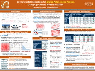
1. Environmental Implications for Shared Autonomous Vehicles
Using Agent-Based Model Simulation
Dan Fagnant & Dr. Kara Kockelman
f
f
Introduction
Shared
Autonomous
Vehicle Fleet...
Google’s Autonomous Prius Car2Go’s Shared Smart Car
Less than 20% of newer (& 15% of all) personal vehicles are in-use at
peak times of day, even with 5-minute pickup & drop-off buffers.
Car-sharing programs like ZipCar & Car2go have expanded quickly, with
the number of U.S. users doubling every year or two over the past
decade.
Shared Autonomous Vehicles (SAVs) can help overcome car-sharing
barriers, like return-trip certainty & vehicle access distances.
An Agent-Based Model Framework
Urban area is gridded, with 900 to 2500 0.25 x 0.25 sq. mile zones.
Trip generation:
Poisson distribution for trip productions per cell.
Higher trip production & attraction rates closer to city center.
Round-trip travel, with most (78%) travelers returning via SAV.
Randomized departure times & trip distances (2009 NHTS).
SAVs travel at fixed speeds, with 5-minute intervals.
AM & PM peak congestion, with speeds slowing by 12 mph.
Scenario Parameters
Example Trip Generation
Relocation Strategies
1) Large Blocks (R1): Area divided into 25 blocks. In blocks with excess
SAVs, the available (unoccupied) SAVs sent to adjacent blocks, while
blocks with few SAVs pull from adjacent blocks, after trips served.
2) Small Blocks (R2): Same idea as R1, but with 100 smaller blocks.
3) Filling in White Spaces (R3): Available SAVs travel to nearby zones,
where no SAV will be within one zone at the start of the next period.
4) Shifting Stacks (R4): SAVs shifted to adjacent zones when the
difference in available SAVs in the next period is 3 or more.
Case Study Evaluations
Initialization: Sets base model’s parameters.
Trip Generations: Generates trips with origins,
destinations, & departure times.
Warm Start: Runs model to estimate the required
numbers & starting locations of SAVs, across zones.
Full Model Run: Simulates SAV travel for one or
more 24-hour days.
Report Results: Outputs summary measures.
Model Operation
0.0%
0.5%
1.0%
1.5%
2.0%
2.5%
3.0%
3.5%
4.0%
4.5%
5.0%
1 2 3 4 5 6 7 8 9 10 11 12 13 14 15
Trip Dist. Distribution (mi.)
0
0.1
0.2
0.3
0.4
0.5
0.6
0.7
0.8
0.9
1
0 1 2 3 4 5 6 7 8 9 10 11 12 13 14 15
Midnight-3AM
3AM-6AM
6AM-9AM
9AM-Noon
Noon-3PM
3PM-6PM
6PM-9PM
9PM-Midnight
Dwell Time Distribution (hrs.)
1 0 0 1 0 0 1 1
0 0 0 0 0 1 1 0
0 0 0 4 0 1 0 0
0 0 2 2 0 1 0 1
0 1 0 1 0 0 3 0
1 1 1 0 2 2 1 0
2 3 1 1 0 0 0 0
0 1 1 0 0 2 0 0
2 2 1 1 1 4 0 4
3 2 4 1 1 1 1 2
2 2 1 1 2 1 3 2
1 1 1 2 0 1 2 3
2 3 0 1 1 1 1 1
0 4 1 0 1 1 3 1
2 4 1 1 1 0 1 1
2 5 1 0 2 3 0 1
Reallocation
-4 -4 -9 3 5 -4 0 -6 3 5
-1 8 5 9 -1 0 1 4 5 3
2 4 -3 -3 12 2 4 -3 2 3
3 0 -6 0 -3 3 -2 -4 0 1
2 0 -8 -6 -5 2 -3 -5 -6 -5
Check block balances
Initial SAV locations
Strategy R1
Environmental Implications
Acknowledgements
We wish to thank the TRB Vehicle Automation Committee for selecting this paper for presentation, the
Southwest Research Institute & ITS America for selecting this paper as the winner of the ITS America Student
Paper Competition, & the Southwest University Transportation Center for funding support. We would also like
to thank Annette Perrone for administrative support, Steve Dellenback of SWRI, & other dissertation committee
members for insights & support.
Strategy R3
Strategy R4
Parameter Value
Service area 10 mi. x 10 mi.
Outer trip generation rate 10 trips / zone / day
Inner trip generation rate 40 trips / zone / day
Off-peak speed 33 mph
Peak speed 21 mph
AM peak 7 AM - 8 AM
PM peak 4 PM - 6:30 PM
Trip share returning by SAV 78%
Measure Mean S.D.
Trips 65,530 360
SAVs 1,908 37.8
Trips per SAV 34.34 0.72
5-minute wait periods 241 175
Avg. wait time per trip 0.26 0.03
Un-served trips 0 0
% waiting 5 min + 0.40% 0.27%
Total VMT 358,100 2,500
Unoccupied VMT 33,030 410
Avg. trip distance 5.39 0.01
Unoccupied mi. per trip 0.5 0.01
% induced travel 10.2% 0.1%
% max in use 98.1% 1.2%
% max occupied 94.7% 2.7%
Hot starts per trip 0.75 0.02
Cold starts per trip 0.059 0.003
Key Results
100 days were simulated to
assess SAV travel implications.
Each SAV can replace 10 to 13
conventional vehicles.
Avg. wait times 15 sec.
Fewer than 1 in 200 travelers
waits more than 5 min.
10.2% new induced travel
generated by unoccupied
vehicles traveling to a new
rider, or relocating to a better
spot.
During the heaviest time of
day, almost 95% of SAVs were
occupied, & 67% of the others
were relocating to better
spots.
Just 0.81 starts per trip, 7.2%
of which are cold starts, vs.
0.94 starts per trip, 68% of
which are cold starts for
conventional vehicles.
Model Variations & Conclusions
Environmental
Impact
Sedan Life-Cycle Inventories Average U.S. Fleet vs.
(Pickup Trucks & SUVs not shown) SAV Emissions Inventories
Operating
(Running)
Manufacture Parking Starts
US Vehicle
Fleet
SAVs Difference % Change
Energy (GJ) 890 100 15 0 1230 1082 -148 -12%
GHG (m. tons) 69 8.5 1.2 0 90.1 84.6 -5.4 -6.0%
SO2 (kg) 3.9 20 3.6 0 30.6 24.6 -6 -19%
CO (kg) 2100 110 5.2 1400 3833 2573 -1260 -33%
NOx (kg) 160 20 6.4 32 243 200 -43 -18%
VOC (kg) 59 21 5.2 66 180 93 -87 -48%
PM10 (kg) 20 5.7 2.7 0 28.2 28.0 -0.2 -0.80%
High trip density & low congestion
are greatest keys to success.
Global-view relocation strategies are
most effective, with R1 reducing long
delays more than R2-R4 combined.
Good level of service possible with
up to 39 trips per SAV (1700 SAVs).
Shared SAVs result in net positive
energy & environmental impacts, though induced travel may be a
concern for small programs.
Future work will apply this framework to an actual urban area, for
trip generation & attraction, as well as incorporating dynamic
ridesharing capabilities.
Benefits from vehicle fleet change, fewer starts & less parking.
But they bring new VMT emissions.
Reductions for energy use & all pollutants, particularly CO & VOCs.
25 additional scenarios tested parameter variations, relocation
strategies & smaller SAV fleets.
Scenario Description
SAVs per
trip
5-minute wait
intervals
Avg. wait
time
% induced
travel
Cold starts
per trip
Base case scenario 34.3 241 0.26 10.20% 0.059
Twice as many trips 35.9 203 0.14 6.60% 0.059
Half as many trips 32.7 303 0.49 11.80% 0.063
A quarter as many trips 30.4 309 0.81 13.10% 0.075
Greater peak congestion* 30.6 2,145 0.32 9.60% 0.071
Less peak congestion* 37.9 136 0.24 10.20% 0.051
Lower SAV Fleet Delays
Selected Scenarios & Results
* Greater peak congestion extends AM and PM peaks by 1 hour each, and reduces peak speeds by 3mph.
Lesser peak congestion reduces AM peak by 0.5 hours, PM peak by 1 hour, and increases peak speeds by 3 mph.