UJJAIN DEVELOPMENT PLAN (Transportation Proposals)
•Download as PPTX, PDF•
2 likes•2,051 views

MADE BY SHRIKRISHNA KESHARWANI 3RD YR ASSIGNMENT BACHELORS OF PLANNING MANIT BHOPAL

Recommended
Recommended
More Related Content
What's hot
What's hot (20)
Similar to UJJAIN DEVELOPMENT PLAN (Transportation Proposals)
Similar to UJJAIN DEVELOPMENT PLAN (Transportation Proposals) (20)
More from shrikrishna kesharwani
More from shrikrishna kesharwani (20)
Recently uploaded
Recently uploaded (20)
UJJAIN DEVELOPMENT PLAN (Transportation Proposals)
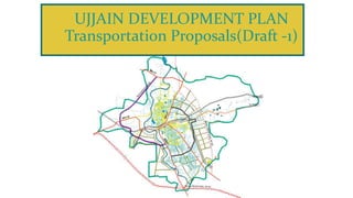
- 1. UJJAIN DEVELOPMENT PLAN Transportation Proposals(Draft -1)
- 2. Regional Connectivity , Existing Transportation Maps , Bus Stops , Bridges, Intersections. EXISTING CONDITION OF TRANSPORTATION 01 Areas Of Proposals. PROPOSALS 02 Approach Adopted For TOD , TOD Corridor. TRANSIT ORIENTED DEVELOPMENT 03 Complete Streets , Last Mile Connectivity , Barrier Free Env. , Inclusive Design. ROADS AND STREETS 04 CONTENTS 06 Complete Streets , Last Mile Connectivity , Barrier Free Env. , Inclusive Design. BUS STOPS , RAILWAYS AND INTERSECTIONS MULTI-MODAL TRANSIT HUB 05
- 3. EXISTING CONDITION ROAD CONNECTIVITY State Highway SH-17, Ujjain Jawra road, join from SH-31 to Jawra, which connects NH-3 at Mahu SH-18 – Dewas-Badnavar, connects NH-3 at Dewas and SH-31 to Badnavar, which connects NH-3 at Mahu. SH -27 Indore Jhalawad, connects NH-3 at Indore and NH-52 at Jhalawad. 6 Regional roads – Indore ,Dewas, Maksi, Badnagar, Agar,Unhel. Simhastha Byepass Bypass has constructed in 2016 for simstha, which has made from Indore road to Unhel Road. There is the road, which connects Unhel and Agar road near to the Unhel Junction. Hence, Indore Badnagar Nagda and Agar road is connected to Simhast bypass road at the outer side of the city. there is the road in front of the government college MR-1, which connects Indore Dewas road. Ring road Heavy traffic was on the SH-27 and SH-18, Proposed Indore to Agar road – RI-1, for reducing the state highway congestion Panchkroshi Marg – Dhatravda-Nolkhibeed until Maksi road, connects Maksi Undasa road with Agar road at MR-5. In 1991 there has proposed RI –1 and RI-2, but in 2021, RI – 1 proposed as Bypass road.
- 4. EXISTING CONDITION PUBLIC TRANSPORT Major bus Terminals - Dewas gate(very congested) which is near to the railway station and the other is at Nanakheda. (came up during simhastha 1992, traffic going and coming to Indore and Dewas.) PROBLEMS Very Few tempo stands. Congestion on intersection (11 intersections given) Busy And congested roads. Improper BRTS System MODE OF TRAVEL Non-motorised -45% , T-W 32% , PRIVATE 23% TRAVEL CHARACTERISTICS 6 regional roads namely Dewas Road, Indore Road, Badnagar Road, Unhel Road, Maksi Road and Agar Road congested (peak hour traffic volume count is nearly 6000 PCU) slow moving traffic- higher in north of the railway line. fast moving traffic- southern part of the city. PARKING Dushhara Maidan Ujjain railways station Freeganj CBD area Makshi Road near by vegetable market Bharatpuri Administrative area Kothi Area Mahakal Commercial area
- 9. CONNECTIVITY Ujjain which is a regional and tourist centre has good linkages by way of road and railway has grown to become a trading and tourist centre in the region. Absence of functional hierarchy of road network. Local roads in CBD area of Ujjain carry heavy goods traffic. Also, absence of service lane on majority of the road network result in inter-mixing up of local traffic and long distance traffic. As the bus existing bus terminal and the rail terminal are in the heart of the city, A redevelopment of the area in form of a multi modal passenger transport hub can be planned. SHIPRA RIVER Flood and natural calamities if development is not done in resilient manner. TOURISM Ujjain is a rapidly growing city and travel demand will continue to grow. There is no escape from having to decongest some of the highly choked areas and intersections in the city Narrow road network with restricted capacity. Absence of essential street furniture elements such as guard rails, street lights, signage, Footpaths etc. There are a number of vacant areas within or outside the existing Government buildings or public places, which could be temporarily used for meeting parking needs SIMHASTHA MELA It has both pros and cons. If there is no proper arrangement for smooth flow of tourists (safety n security) chances asises for stampede . Sufficient land use for transportation. Acc. To development plan 2035- 18.52% of land use is given for transportation. High two wheeler vehicle ownership in the city (higher mobility potential) Share of bus transport in the total trips is alarmingly low as 3% which is one of the main causes for an increase of private modes and traffic in the city. A tourist circuit can be developed in the city for the tourist centric trips. The regional connectivity could be improved for better development of the city. s w o T
- 10. PROPOSAL AREAS • Section and elevation for Complete Road Streets, Major city roads Proposed + Existing • (Electricity by speed breakers Major roads near NMT (residential) . • Routes for Minibus , Tempo and public transportation. • Intersection redesign • Bus stops Renovation and one new bus stop proposed • Railway Stations Renovation and connectivity with Roads • TOD Nodes Identification • Multimodal Transit Hub • Complete info. of TOD Zones • Parking • ITMS
- 11. PROPOSALS DDP-2035 Railways – Improvement Development -2021 ( Dewas Road , Vikram Nagar, Roti Nagar connected by the railway station) PROPOSALS- 1.Vikram Nagar Railway station Redevelopment.(unnyan) 2. Chintaman Railway needs to be developed in order to reduce traffic and Tourist load during religious festivals. 3. Road from Vidyaman marg to chintaman railway station to be developed in 4 lane. Bus stands – Dewas gate Bus stand near Railway station , to reduce the increasing number of buses, Indore- Ujjain road bus stand has been constructed (2021) PROPOSAL-Two bus stands are proposed near Vikram Nagar Railway Station and Makodiyaam agar Road. National Highway PROPOSALS -1. NHAI in the planning area of Ujjain in the direction of South-west and Northern part Ujjain- Garoth and the Dewas-Badnagar National Highways are Proposed. 2. Regional Road- Dewas and Indore – 4 lane OTHER PROPOSALS – Development of Major intersections of the city , ROW , Dividor, Foothpaths,Cross section (complete streets),central street lights to be done , Widening of Major Roads.
- 13. TRANSIT ORIENTED DEVELOPMENT Imagine waking up in a new, Mixed-use Apartment Block , and Strolling to the nearest Transit Station, which is five minute walk away. On route you drop of laundary to dry cleaner , whose street facing shop is on the ground floor of your Apartment building. Young Mothers are ferrying babies in strollers to the neighbourhood Public park for morning outing. Vegetable vendors are setting up their produce for the day in designated spots on the Pavement. Cyclists pass by in segregated cycle lanes.Buses,Cars,Motorcycles and scooters keep to themselves on roads,out of reach of Padestrians.Designated crossing allow you to access the transit station and reach the platform safely, without any unanticipated collisions with a vehicle of any kind. Is this Newyork,London or Sanghai? This could be Ujjain if it chooses to adopt Transit-Oriented-Development.
- 20. LAND USE BUS ROUTE SLOPE TOD LAYERED APPROACH SLUMS DRAINAGE TOD TRANSIT CORRIDORS
- 21. MULTIMODAL TRANSIT HUB Location of Railway Station and Bus Terminal in Ujjain PROJECT BRIEF The Area Based Development (ABD) synergise two symbiotic nodes first the "Mahakal Area" as Religious and Cultural Hub (RCH) for revitalization of the tourism experience and other the "Mill Area" to be developed as Knowledge and Economic Hub (KEH) to nurture diverse knowledge based economic activities, efficiently served by Multi-modal Transit Hub (MMTH) in "Railway Station Area". Development of regional bus terminal, transit plaza, parking, Mixed use TOD development, in and around railway station will further foster the city development.
- 22. Proposed Site Details LOCATION AND CONNECTIVITY The Project site is located at Dewas Gate Bus terminal which is adjacent to Ujjain Junction railway station integrating Rail, Bus and Para transit. The Dewas gate bus stand is very crowded since all the intercity and interstate buses, except going and coming to Dewas and Indore, starts and terminates at this bus terminal. Project site is circumscribed by SH 27 toward the West, Shastri Bridge road toward the North, and local roads towards south. The Railway station area with its emphasis on Dewas gate bus Station and the focal Ujjain Junction Railway Station consequently qualifies as a standout amongst the most dynamic transport hubs.
- 23. Proposed Site Details LAND OWNERSHIP The proposed project site which has a total area of 4.42 acre, comprising Dewas gate bus station, Dewas gate Police station and a post office. Including all the 3 components within, the land ownership of the overall project area lies with Ujjain Municipal corporation. At present the Post Office and the Police Station is operational on the site and the same would be shifted for the development of the Transit Hub Project. 1. Dewas gate Bus station 2. Head Post Office 3. Dewas gate police station Image: Indicative representation of Bus terminal, Post Office & Police station
- 24. Proposed Site Details ROAD HIERARCHY The Road network of Ujjain City has been classified based on Functionality due to its presence in Core area. A Major share of the Road network within the ABD area falls under the category of Collector and Local roads. • The classification of the road based on their function: - • Arterial Road • Sub-Arterial Road • Collector Road • Local Road Map showing Road Hierarchy around the Study Area
- 25. Proposed Site Details NEIGHBOURHOOD Railway station area at Dewas gate is an upcoming trip generating area in Ujjain and has witnessed a steady growth over the last couple of years. The immediate neighborhood within 2-3 km radius of the Transit Hub site is a mix of educational, recreational, commercial and residential developments situated. • Major Recreational places such as Mahakaal temple, Triveni museum, Vikram teela, Jantar mantar etc. • Ujjain Municipal corporation, Ujjain RTO, Simhastha mela office and Vikram University are in close proximity to the project site. • Nearby Tourist Centric locations, CBD and commercial area (Freeganj). Existing landmarks neighbouring to the project site
- 26. Proposed Transit Hub Project The project will serve as a land mark Transit Oriented Development (TOD), integrating public & private transport with large scale commercial and retail development. The project facilities may include: • Transit hub facility including adequate numbers of bus and paratransit bays to take care of inter-city, intra-city, para-transit demand; • Passenger transfer facility centre for safe and seamless transfer of passengers between railway station and Bus terminal. • Commercial development including high quality office, retail, hospitality and other facilities; • Multi-level car parking for commuters and other users of the development. PARAMETER DESCRIPTION Location Dewas gate Bus station adjacent to the Ujjain Junction railway station and with direct access through State Highway 27. Area Land use Currently Public Semi Public (PSP) Built-up Area 2.88 Lakh square feet Indicative Project Confuguration ▪ Bus terminal with a minimum of 30 operational bays, and 50 bus parking bays. ▪ 500 ECS Multi-level smart parking. ▪ Bus terminal and passenger facilities, Transit plaza & Food Court of around 1.2 lakh square feet. ▪ Integration with the existing Ujjain junction railway station. ▪ Commercial office and Retail space development of around 1.65 lakh square feet. 4.42 acres
- 27. 5.2 KM Total length
- 28. TYPICAL 45 MTWIDE BRTS ROAD SECTION LOCATION OF UNDERGROUND UTILITIES LOCATION OF UNDERGROUND UTILITIES VENDING /ACTIVITY ZONE VENDING /ACTIVITY ZONE FRONTAGE ZONE PEDESTRIAN PATH CYCLE TRACK MULTI FUNCTIONAL ZONE MOTORISED VECHILES LANE OVERTAKING LANE BUS LANE BUS STATION BUS LANE OVERTAKING LANE MOTORISED VECHILES LANE FRONTAGE ZONE PEDESTRIAN PATH CYCLE TRACK MULTI FUNCTIONAL ZONE PROPERTY LINE BUILDINE LINE PROPERTY LINE BUILDINE LINE 6.50 3.00 2.10 2.50 3.00 6.10 4.00 6.10 6.50 3.00 2.50 2.10 3.00
- 29. Most of thee roads proposed for widening Lies at the central area as most of the traffic Congestion is also there.
- 32. Proposal for road widening Proposed roads after widening 6.5 meter 12.5 meter Vehicles are parked At the pedestrian path Results in congestion Pedestrian friendly Solution-
- 33. Proposal of Parklets • A parklet is a sidewalk extension that provides more space and amenities for people using the street. Usually parklets are installed on parking lanes and use several parking spaces. • Parklets typically extend out from the sidewalk at the level of the sidewalk to the width of the adjacent parking space. • Parklets are intended for people. Parklets offer a place to stop, to sit, and to rest while taking in the activities of the street. In instances where a parklet is not intended to accommodate people, it may provide greenery, art, or some other visual amenity.
- 34. Parklets are miniature parks, funded, designed, built and maintained by the applicant (often a neighboring business) or community volunteers, so there’s no cost to taxpayers. . Parklets prioritize the pedestrian experience and aim to improve the neighborhood vibe, often with the addition of bike racks and seating
- 35. ACCORDING TO UJJAIN DEVELOPMENT PLAN
- 37. PROPOSALS FOR SPEED BREAKERS A speed breaker is a hump surface across the roadway having a rounded shape with width greater than the wheel base of most of the vehicles using the road. When there is decrease variation in sensory stimuli and at locations where speed controls are desired, a speed breaker acts as a strong stimuli to arouse reaction in the brain. Since the driver reaction times are faster in response to audible and tactile stimuli than to visual stimuli, a driver subconsciously reduces the speed. An ideally designed hump should satisfy the following requirements: i. There should be no damage to vehicles nor excessive discomfort to the drivers and passengers when passing at the preferred crossing speed. ii. The hump should not give rise to excessive noise or cause harmful vibrations to the adjoining buildings or affect the other residents of the area. iii. Above the design speed, a driver should suffer increasing level of discomfort (but without losing directional control and without any vehicle damage) depending on the extent through which design speed is exceeded.
- 38. PROPOSAL – TYRE KILLER • It is the type of speed breaker proposed not only for the reduce to the speed of vehicles, also make reduction in the frequency of accidents causing by the wrong side movements. • It is not for the negative intentions and harm the vehicles, it is simply for the make a discipline on the roads, • It puts on the streets in the same direction of the movements of the roads, which do not harm the vehicles moving on the right direction, it automatically goes down into the hard structure, • Installation of “tyre killer” has started in the Noida and Pune for reducing the frequency of wrong movements. 01 Reference link -https://www.youtube.com/watch?v=w3jhzfgF4LY
- 39. PROPOSAL - ELECTRICITY GENERATION BY THE SPEED BREAKER • The electricity became a most important part of the human lives, concepts of conservation and reuse of the energy and it can be a good resource of the energy in the future, • The concept of energy generation from the speed breaker can be an affective idea to generate energy from the vehicular pressure, • The process of energy generation is, the speed breaker will have some high from the road surface which will done by the springs, and will be connected with the DC motor and battery, when the vehicle pass from the speed breaker, the pressure from the vehicles will do some work which will generate electricity under the road surface and can be save in the batteries, • This power can be used in the street lights, traffic signals and in the other public uses, it can be install in the higher traffic areas to more electricity generation. M.ISWARYA, Mrs.G.R.P.Lakshmi, Department of EEE Sathyabama University - Generation of Electricity by using Speed Breakers Reference link https://www.youtube.com/watch?v=8djfPt4mlKs 02
- 40. PUBLIC TRANSPORT-BUS Public transport is a system of transport, for passengers by group travel systems available for use by the general public, typically managed on a schedule, operated on established routes, and that charge a posted fee for each trip. EXISTING BUS STAND Dewas gate bus stop Nankhede bus stop Proposed bus stand Indra nagar makodia Bus transit-oriented development; strengths • Complementarity and iniquitousness • Flexibility of choice • Adaptiveness to change • Cost effectiveness • Service frequency, etc.
- 41. PRESENT SCENARIO Dewas gate bus stand Area-0.61 Hectares Nankhede bus stop Area -1.64 Hectares Some of the major problems associated with the bus terminal are; • Access roads leading to Dewas Gate bus terminal are narrow and often encroached by hawkers, shopkeepers and parked vehicles. Jamming conditions are readily observed at the time of arrival and departure of buses. • Total lack of terminal planning principles and design criteria in the development and operation of Dewas Gate terminal complex. Inadequate facilities within the bus terminal in terms of bays, administrative area, boarding alighting platforms and circulation.
- 42. PROPOSALS • Separate gates for entry and exit • Vending machine for tickets • Display-Boards • buy e-ticket • charging point • Pink toilets • Vending water machines • Smart lights • Solar panels • wifi
- 43. LOCATION OF PROPOSED BUS TERMINUS AREA- 3.62 ha
- 44. A case study of California Solar Powered Bus Stops The Sunshine State has more than its fair share of active sustainable projects that help reduce statewide energy costs considerably. The newest addition to this list is the solar powered bus stop which would help otherwise normal bus stops double as miniature power plants. • This bus stop will feature a roof fitted with 1.2 kilowatt solar arrays. • which would capture the sun’s heat, convert it into usable energy and use the same to power the traffic lights in the area. • Excess solar power will be stored on an onsite battery to continue powering the lights as well as the bus stop itself at night. Multi-functional solar powered bus stop with user friendly features This bus stop is illuminated by modules. It uses the internet and keeps informing the passengers waiting there about the transport schedules. This bus stop has been designed and developed by Canadian research engineers from the McMaster University. The stop is run by the flexible solar cell technology.
- 45. Other major Proposal (for buses and bus stop) Sensors opening doors The height of the stop will be equivalent to bus floor(good for wheelchair ,children's and old age Vending machine for ticket and mobile app for better facilities. Ac busses , camera,seprate seating space, for female and old age GPS tracking system Electronic display inside buses and bus stop for information of incoming next stop and next buses. Wi-Fi charging point, inking facilities at bus stop. Separate doors for entry and exit. Parking facilities Rickshaws charging station Interconnected street Promote electric Rickshaws. especially MAHAKAL area Ramp and levelling along the with adequate sidewalk in account with Barrier free environment Bicycle sharing facility. Connecting bus stop. Road and side walk lighting along with adequate furniture. Way finding direction sign. Permeable and recycled pavement. Facility like street trees garbage cans, public washroom, Drinking water and public art Project utthan, SMART CITY
- 46. PARKING Parking is the act of stopping the vehicle and leaving it unoccupied at a particular place for a period of time. The Transit Oriented Development focuses on discouraging the use of private vehicle to manage parking with subsequent parking reduction and making it expensive with the influence zone. Parking should not be allowed in a manner wherein the aesthetics of the city is lost. TOD restrict unauthorized parking and avoid congestion caused due to street parking making enforcement mechanism in place an important factor.
- 47. EXISTING PARKING • Mahakal temple parking • Mahakal parking • Krishna car parking • Multi level parking (mirza naim beg road) • Dhannji car parking( near mailpura) • Parking ( Ujjain junction) • Parking ( Ujjain dews road) • Multi level parking (Ujjain dews road) • Shree nageshwar parking(nankheda bus stand) • Treasure mall parking Proposed parking • Dussehra maid an • Freeganj • Ujjain maxi road • Kothi road • Mahakal commercial area • Bharatpuri prashasnic area PARKING
- 48. PROPOSAL Smart parking • Optimized parking • Reduced Traffic • Reduced Pollution • Improve user experience • Increased Safety • Real-time data • Decrease management costs Smart Parking solutions combine the technology and human innovations to save the resources like space, fuel, time in the fast and easy manners. Parking and Transportation are important for both people and to achieve goods. The smart system that enables the vehicles to move with the user’s plan and activities and thus helps people to move around to and fro and back again to their destined place. Mostly smart parking are use in the CBD area. Because this type of parking taking minimum place .