Downloaded 157 times


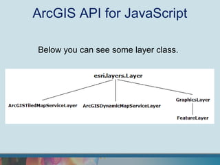

![ArcGIS API for JavaScript
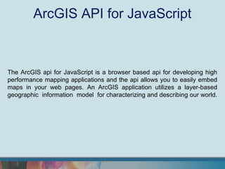
ArcGISDynamicMapServiceLayer / 1
var lvisible = [0];
var param = { "transparent": true };
var layer = new esri.layers.ArcGISDynamicMapServiceLayer(url, param);
layer.setVisibleLayers(lvisible);
map.addLayer(layer);
The code above perform a query on a DynamicLayer (return a dynamic map).](https://image.slidesharecdn.com/arcgisjavascriptapilayermapdojowidget-120930083233-phpapp02/85/ArcGIS-JavaScript-API-build-a-web-layer-based-map-application-with-html5-and-javascript-11-320.jpg)
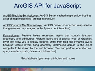
![ArcGIS API for JavaScript
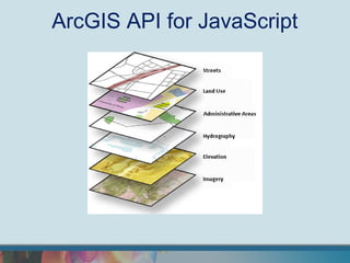
ArcGISDynamicMapServiceLayer / 2
var layerDefs = [];
layerDefs3[5] = "STATE_NAME='Kansas'";
layerDefs3[4] = "STATE_NAME='Kansas' and POP2007>10000";
layerDefs3[3] = "STATE_NAME='Kansas' and POP2007>10000";
var imageParam = new esri.layers.ImageParameters();
imageParam.layerDefinitions = layerDefs;
imageParam.layerIds = [5, 4, 3];
imageParam.transparent = true;
var layer = new sri.layers.ArcGISDynamicMapServiceLayer(url,
{"imageParameters": imageParam }
);
map.addLayer(layer);
The code above perform a query on a DynamicLayer (return a dynamic map).](https://image.slidesharecdn.com/arcgisjavascriptapilayermapdojowidget-120930083233-phpapp02/85/ArcGIS-JavaScript-API-build-a-web-layer-based-map-application-with-html5-and-javascript-12-320.jpg)
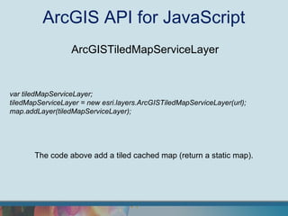
![ArcGIS API for JavaScript
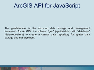
FeatureLayer
var layer = new esri.layers.FeatureLayer( url , {
mode: esri.layers.FeatureLayer.MODE_SNAPSHOT,
outFields: ["NAME", "POP2000", "POP2007", "POP00_SQMI", "POP07_SQMI"]
});
layer.setDefinitionExpression("STATE_NAME = 'Kansas'");
layer.setRenderer(new esri.renderer.SimpleRenderer(symbol));
map.addLayer(layer);
The code above perform a query on a FutureLayer.
You can perform operation as: query, create, update, delete (are interactive).](https://image.slidesharecdn.com/arcgisjavascriptapilayermapdojowidget-120930083233-phpapp02/85/ArcGIS-JavaScript-API-build-a-web-layer-based-map-application-with-html5-and-javascript-13-320.jpg)
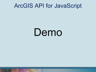
![ArcGIS API for JavaScript
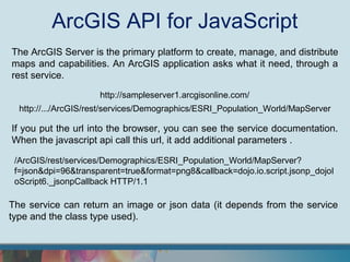
QueryTask
var queryTask = new esri.tasks.QueryTask(url);
var query = new esri.tasks.Query();
query.outSpatialReference = { wkid: 102100 };
query.outFields = ["STATE_NAME", "CITY_NAME“, "MALES", "FEMALES"];
query.where = "STATE_NAME =‘California’ ";
queryTask.execute(query, callback);
A QueryTask perform a query and return json data.](https://image.slidesharecdn.com/arcgisjavascriptapilayermapdojowidget-120930083233-phpapp02/85/ArcGIS-JavaScript-API-build-a-web-layer-based-map-application-with-html5-and-javascript-14-320.jpg)

The ArcGIS API for JavaScript is a browser-based tool for developing high-performance mapping applications, allowing users to embed maps in web pages and interact with geospatial data. It utilizes a geodatabase for data management, supports layer-based modeling, and enables operations like querying and updating features dynamically. Developers can access the API through the Dojo framework and use various service layers, including tiled and dynamic map services, to enhance their applications.


