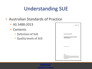
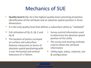
Subsurface Utility Engineering
Location and damage prevention of
underground utilities
Subsurface Utility engineering
• Understanding SUE
• Why SUE is important?
• Mechanics of SUE
UNDERSTANDING SUE
What is SUE: definitions and application within the law in Australia
Understanding SUE
• Subsurface Utility engineering is an engineering
practice that encompasses the management or
risk associated with many aspects of
infrastructure project management such as:
• Underground utility relocation
• Infrastructure planning and estimation
• 3D mapping of utilities for design
• Correct identification and location of underground
utilities
• Road and Highway upgrades
Understanding SUE
• Australian Standards of Practice
• AS 5488-2013
• Contents
• Definition of SUE
• Quality levels of SUE
WHY SUE IS IMPORTANT?
Managing and preventing risks | Infrastructure management
Why is SUE Important?
• Prevention of damages to existing subsurface
• Power
• Water
• Gas
• Sewer
• Drainage
• Communications
• CCTV
• Data
• Fuel
Why is SUE important?
• We can’t rely purely on One Call (DBYD)
systems or GIS overlays to provide accurate
location of underground utilities.
Why SUE is important?
• Risk management is the essence of SUE, by utilizing all aspects of SUE
your are minimizing costly delays and potentially saving lives.
• Risks under control with SUE
• Project delays
• Damage to critical utilities
• Safety of the public
• Environmental damage
• Costly design errors
• Insurance claims
• Loss of reputation
• Time / Budget penalties
MECHANICS OF SUE
How does it work?
Mechanics of SUE
• Before engaging in any subsurface activities,
following the following step is recommended:
Mechanics of SUE
• Australia recently released AS 5488-2013
defining the quality levels of SUE
• Quality level A
• Quality level B
• Quality level C
• Quality level D
Mechanics of SUE
 Existing records
 Cursory site inspection
 Anecdotal evidence
 Utility owner
 Indication of utility type
 The date of installation
 An indicative location of the
surface and subsurface features
 The date the data was captured
 The source of information
• Quality level D (QL-D) is the lowest quality level.
• The attribute information and metadata of a subsurface utility
can be compiled from any, or a combination of the following:
Mechanics of SUE
Mechanics of SUE
 Full utilization of QL-D
 An interpolation of the location
and direction of the utility using
surface features as points of
reference
 Feature codes of surface
features, pits, access chambers,
poles, valves and hydrants
 The location of surface features
measured in terms of relative
spatial positioning with a
maximum horizontal tolerance of
+/-300mm
• Quality level C (QL-C) is described as a surface feature correlation.
• It is achieved using a combination of existing records and a site
survey of visible evidence
Mechanics of SUE
Mechanics of SUE
 Full utilization of QL-D & QL-C
 The location of subsurface
features measured in terms of
relative spatial positioning with a
maximum horizontal tolerance of
+/-300mm and a maximum
vertical tolerance of +/-500mm
 The locating method(s) used to
obtain the attribute information
• Quality level B (QL-B) provides relative subsurface feature locating
in three dimensions
• The minimum requirements for QL-B Is relative spatial positioning:
Mechanics of SUE
Mechanics of SUE
 Full utilization of QL-D, QL-C and
QL-B
 The location of points surveyed
on surface and subsurface
features measured un terms of
absolute spatial positioning with
a mac Horizontal and vertical
tolerance of +/-50mm.
 Survey control information used
to determine the absolute spatial
position of the utility
 The survey and locating methods
used to obtain the attribute
information
 Utility type, status, material, size
& configuration
• Quality level A (QL-A) is the highest quality level consisting of positive
identification of the attribute and an absolute spatial position in three
dimensions.
• It is the only quality level that defines a subsurface utility as “validated”
Mechanics of SUE
THANK YOU
Questions?
Contact admin@advancescanning.com.au or call (08)6102 3626

Subsurface Utility Engineering - 2013 - by Advance Scanning Services

  • 1.
    Subsurface Utility Engineering Locationand damage prevention of underground utilities
  • 2.
    Subsurface Utility engineering •Understanding SUE • Why SUE is important? • Mechanics of SUE
  • 3.
    UNDERSTANDING SUE What isSUE: definitions and application within the law in Australia
  • 4.
    Understanding SUE • SubsurfaceUtility engineering is an engineering practice that encompasses the management or risk associated with many aspects of infrastructure project management such as: • Underground utility relocation • Infrastructure planning and estimation • 3D mapping of utilities for design • Correct identification and location of underground utilities • Road and Highway upgrades
  • 5.
    Understanding SUE • AustralianStandards of Practice • AS 5488-2013 • Contents • Definition of SUE • Quality levels of SUE
  • 6.
    WHY SUE ISIMPORTANT? Managing and preventing risks | Infrastructure management
  • 7.
    Why is SUEImportant? • Prevention of damages to existing subsurface • Power • Water • Gas • Sewer • Drainage • Communications • CCTV • Data • Fuel
  • 8.
    Why is SUEimportant? • We can’t rely purely on One Call (DBYD) systems or GIS overlays to provide accurate location of underground utilities.
  • 9.
    Why SUE isimportant? • Risk management is the essence of SUE, by utilizing all aspects of SUE your are minimizing costly delays and potentially saving lives. • Risks under control with SUE • Project delays • Damage to critical utilities • Safety of the public • Environmental damage • Costly design errors • Insurance claims • Loss of reputation • Time / Budget penalties
  • 10.
    MECHANICS OF SUE Howdoes it work?
  • 11.
    Mechanics of SUE •Before engaging in any subsurface activities, following the following step is recommended:
  • 12.
    Mechanics of SUE •Australia recently released AS 5488-2013 defining the quality levels of SUE • Quality level A • Quality level B • Quality level C • Quality level D
  • 13.
    Mechanics of SUE Existing records  Cursory site inspection  Anecdotal evidence  Utility owner  Indication of utility type  The date of installation  An indicative location of the surface and subsurface features  The date the data was captured  The source of information • Quality level D (QL-D) is the lowest quality level. • The attribute information and metadata of a subsurface utility can be compiled from any, or a combination of the following:
  • 14.
  • 15.
    Mechanics of SUE Full utilization of QL-D  An interpolation of the location and direction of the utility using surface features as points of reference  Feature codes of surface features, pits, access chambers, poles, valves and hydrants  The location of surface features measured in terms of relative spatial positioning with a maximum horizontal tolerance of +/-300mm • Quality level C (QL-C) is described as a surface feature correlation. • It is achieved using a combination of existing records and a site survey of visible evidence
  • 16.
  • 17.
    Mechanics of SUE Full utilization of QL-D & QL-C  The location of subsurface features measured in terms of relative spatial positioning with a maximum horizontal tolerance of +/-300mm and a maximum vertical tolerance of +/-500mm  The locating method(s) used to obtain the attribute information • Quality level B (QL-B) provides relative subsurface feature locating in three dimensions • The minimum requirements for QL-B Is relative spatial positioning:
  • 18.
  • 19.
    Mechanics of SUE Full utilization of QL-D, QL-C and QL-B  The location of points surveyed on surface and subsurface features measured un terms of absolute spatial positioning with a mac Horizontal and vertical tolerance of +/-50mm.  Survey control information used to determine the absolute spatial position of the utility  The survey and locating methods used to obtain the attribute information  Utility type, status, material, size & configuration • Quality level A (QL-A) is the highest quality level consisting of positive identification of the attribute and an absolute spatial position in three dimensions. • It is the only quality level that defines a subsurface utility as “validated”
  • 20.
  • 21.