Space 134 - Potential for Transit Connections
•
0 likes•1,297 views

By integrating local and regional transit connections into the Space 134 project, we visitors and residents may benefit from a greater range of mobility options.
Report
Share
Report
Share
Download to read offline

Recommended
Space 134 - Caltrans Transportation Concept Report (2012)
Space 134 - Caltrans Transportation Concept Report (2012)Community Development Department-Glendale, CA
This Transportation Concept Report analyzes State Route 134 in California over the next 20 years. It documents current conditions, projects future demand, and proposes alternatives to address shortfalls between demand and capacity. The key alternatives include: Alternative #1, which generally conforms to regional plans and provides congestion relief; Alternative #2, which suggests more HOV lanes; and an "Attain LOS D" alternative to illustrate future needs. The report aims to suggest a configuration for Route 134 that meets projected demands within framework of regional policy goals like improving mobility and reducing vehicle miles traveled.Transit Recommendations for the Space 134 Project
Draft recommendations for transit design, infrastructure and services related to the Space134 Project.
Preliminary Report: Space 134 Project Implementation, Operation & Economic Be...
Preliminary Report: Space 134 Project Implementation, Operation & Economic Be...Community Development Department-Glendale, CA
A preliminary analysis of the possibilities for implementing and operating the proposed Space134 cap park project, as well as the project’s potential economic benefits.Space 134 - FAQs
Is Space 134 a done deal? Will my taxes go up? Get your Space 134 questions answered and get the basic facts about design, operation, construction and funding.
Space 134 - RFP for Glendale Freeway Ramps/Vision Plan
The City of Glendale is seeking to obtain the services of a well-qualified firm or team of firms, specializing in environmental planning, traffic analysis, civil/structural engineering, and urban design, to study and develop the road and transportation network surrounding Space 134 as it passes through downtown Glendale.
2013 Space 134 Vision Plan
The 2013 Vision Plan for the proposed cap park over the 134 freeway in Glendale, CA.
Visit www.Space134.net for more information.
121224 railyards summary_memo_reduced
This document provides a summary of a study evaluating the potential for transit-oriented development at the 4th and King Street Railyards in San Francisco. It describes the existing conditions, including surrounding land uses and height limits. Two development scenarios were analyzed: one assuming development above the existing railyards, and a "blank slate" scenario. Key findings from the study will inform future planning and design efforts for the site once the rail configuration is finalized. The study aims to evaluate development capacity and potential revenue generation to support rail investments.
05.ENTRIPS
The document summarizes the analysis of circulation and operations for proposed transportation corridor projects in the Eastern Neighborhoods of San Francisco. It assessed potential impacts on traffic, the transportation network, transit delay, and signal timing. The analysis evaluated different design alternatives for Folsom Street, Howard Street, 7th Street, and 8th Street that vary the number of vehicle lanes, inclusion of transit and bicycle facilities, and direction of traffic flow. The preferred alternatives balance moving people by all modes efficiently while minimizing negative impacts to traffic flow and livability in the neighborhoods.
VC Research Final tcb
This document summarizes a study on coordinating value capture to fund transit capital projects. It presents case studies of projects in San Francisco, Washington D.C., New York City, and Chicago that effectively coordinated between transit agencies, municipal authorities, and private developers. The case study on San Francisco describes a project to realign the Muni M-Line through the Parkmerced neighborhood, funded primarily by the private developer through a joint development agreement. The Washington D.C. case study examines a new Metro station funded in part through a special taxing district that captured value from surrounding new development. The document concludes that successful coordination requires experienced public staff and organizational structures that facilitate collaboration between public and private entities.
pt 3: The Quickway Proposal: Central Zone
The Quickway Proposal was developed by San Diego citizens who want to see an affordable, efficient, convenient, world-class transit system developed here. This detailed series is composed of nine presentations. Part 3 shows our proposal for the Central Zone of the County.
pt 4: The Quickway Proposal: South County
The Quickway Proposal was developed by San Diego citizens who want to see an affordable, efficient, convenient, world-class transit system developed here. This detailed series is composed of nine presentations. Part 4 shows our proposal for South County.
Scag nop comment letter
The City of South Pasadena provided comments on SCAG's Notice of Preparation for the 2016-2040 RTP/SCS PEIR. Key issues raised included: 1) Inclusion of the SR-710 North tunnel project is flawed and should not influence the separate SR-710 North Study; 2) Labeling the SR-710 project as a "gap closure" is inaccurate; 3) A SR-710 tunnel is not financially constrained; and 4) The PEIR needs to prioritize GHG reduction and VMT reduction over mobility and economic goals to comply with state law. The city urged SCAG to recognize changed circumstances and legal requirements to prepare an adequate PEIR for the 2016 plan.
Apett Presidential Lecture The National Network Of Highway Projects And The...
The Government of Trinidad and Tobago in 2009 proposed to embark on a National Network of Highways Project (NNHP) that would see the construction of a number of cross country highways. Notwithstanding the obvious benefits of the NNHP, the immediate challenge faced by commuters and motorists throughout the country is the transportation crisis that exits in the major urban centers as a result of the inadequacy and lack of development of the transport infrastructure in these fast growing commercial centers. This presentation discusses the major elements of the NNHP and the traffic gridlock crisis that exists in some of the urban centers around the country in relation to the short, medium and long term recommendations of a Comprehensive National Transportation Study (CNTS) undertaken in 2005/06
pt 8: The Quickway Proposal: North County
The Quickway Proposal was developed by San Diego citizens who want to see an affordable, efficient, convenient, world-class transit system developed here. This detailed series is composed of nine presentations. Part 8 shows our proposal for North County.
Passenger Trains For South Hampton Roads Norfolk Southern 7 17 09
Passenger Trains For South Hampton Roads Norfolk Southern 7 17 09Hampton Roads: America's First Region
1) Norfolk Southern's freight rail route between Norfolk and Petersburg, Virginia could potentially host passenger trains with some upgrades to accommodate higher speed trains up to 79 mph.
2) Additional infrastructure would need to be built, such as adding new tracks to allow space for passenger trains without disrupting freight traffic. Stations would also need to be constructed.
3) Securing federal funding for infrastructure upgrades and state funding for ongoing operations costs are necessary next steps to establish passenger rail service between Norfolk and Richmond.Bus Rapid Transit: The Next Opportunity for TO D (Roger Moliere) - ULI fall m...
The document discusses Bus Rapid Transit (BRT) systems in Los Angeles County as an opportunity for Transit Oriented Development (TOD). It provides an overview of the Metro Orange and Silver Line BRT systems, including their dedicated transitways and mixed traffic areas. It also discusses Metro's focus on TOD at rail stations and opportunities to expand TOD to BRT corridors, including studies of the Metro Orange Line corridor.
Antoine's Resume
This document is a resume for Antoine Elasmar, a traffic engineer seeking a position to further his career goals and experience. It outlines his education credentials including a Master's and Bachelor's degree in Civil Engineering. It also lists his employment history including his current role as a Traffic Engineer at URS Corporation/AECOM and an internship with Bassil Construction Company. Finally, it provides details of his skills, software proficiencies, and relevant traffic engineering projects and responsibilities.
Scarborough Transit Town Hall - April 23, 2016
For more information, see http://scarboroughsubwayextension.ca
Do not include any personal information as all posted material on this site is considered to be part of a public record as defined by section 27 of the Municipal Freedom of Information and Protection of Privacy Act.
We reserve the right to remove inappropriate comments. Please see Terms of Use for City of Toronto Social Media Sites at http://www.toronto.ca/e-updates/termsofuse.htm.
M9-EIA-Draft Final Report
This document provides an executive summary of the Environmental and Social Impact Assessment for the proposed Karachi-Hyderabad M-9 Motorway project in Pakistan. The project involves upgrading the existing 4-lane Karachi-Hyderabad highway to a 6-lane motorway. Potential environmental and social impacts of the project during construction and operation phases are identified, and mitigation measures are proposed to reduce negative impacts. Key project features and the existing environment along the project area are also described.
1 roads classification
This document discusses the functional classification of roads which involves grouping roads based on the type of service they provide to traffic flow. It describes how functional classification establishes a road network hierarchy that channels trips efficiently from local roads to collector roads to arterial roads. The classification considers a road's role in providing both access to adjacent properties and mobility for through traffic. Additional factors like trip distances, traffic volumes, and the proportion of commercial vehicles vary based on a road's functional class. The purposes of functional classification include delineating responsibilities, planning road standards, and assisting road users.
Systems Level Approach To Sustainable Urban Arterial Revitalization
This document presents a methodology for revitalizing urban arterials in a sustainable manner. It discusses analyzing all connected aspects, including land use, transportation, traffic, and community outreach. As a case study, it applies this framework to San Pablo Avenue in the San Francisco Bay Area. The analysis results in land use and transportation recommendations to facilitate sustainable development along the corridor by considering these various interconnected factors.
GIS442FINALREPORT
This document summarizes a project analyzing public transportation gaps in Bothell and Woodinville, WA. Key findings include:
- Areas west of Bothell and the Woodinville tourist district have low accessibility to bus stops and could benefit from improved transit services.
- Alternative services like community shuttles or ridesharing apps could help connect low-accessibility suburban neighborhoods.
- The Woodinville tourist area, Bothell Park & Ride, and Canyon Park are highly trafficked locations that would benefit from new bus stops.
Traffic enginering highway capacity and los presentation
This document provides an overview of highway capacity and level of service analysis for multilane highways. It defines key terms like capacity, level of service, and qualitative service categories. It also outlines the methodology for determining the level of service for a multilane highway, which involves calculating the free-flow speed, flow rate, density, and matching the density to the appropriate level of service category. An example problem demonstrates how to apply the methodology to analyze field data and determine the peak hour level of service, speed, and density for a highway segment.
Resume_Stantec_2016_10
This document provides information on Douglas K. Iles, a project engineer with over 20 years of experience in traffic engineering projects for both public and private sector clients. It includes a summary of his relevant work experience conducting traffic impact studies, signal timing plans and coordination projects, safety studies, and more. It also lists his educational background and professional registrations.
Union City Letter to Samtrans Dumbarton Corridor
This letter from the City of Union City to SamTrans provides comments on the Dumbarton Transportation Corridor Study Draft Final Report. The key points made are:
1) The final report should document prior engineering work completed for connecting Dumbarton Rail to Union City BART via the Centerville Line and Oakland Subdivision.
2) The report should clarify that the ACEforward Alternative CNS-1a, if selected, would provide sufficient capacity on the Centerville Line for Dumbarton Rail, ACE and Capitol Corridor trains to connect at Centerville Station.
3) The report should recognize funding opportunities through ACTC Measure BB and the ability for Dumbarton
Experience Record
The document outlines Ibrahim El Zein's experience with various transportation and infrastructure projects in Saudi Arabia and Lebanon. Some of the key projects mentioned include designing upgrades to the Thumamah Road Corridor in Riyadh, Saudi Arabia and studying and designing primary road networks in Riyadh. Other projects involved transport planning for new developments like the K.A.CARE Master Plan city near Riyadh and the Bawabat Makkah new city. Ibrahim El Zein also worked on establishing a Roads and Transport Research Center in Saudi Arabia and conducted traffic studies for projects in Lebanon.
Sr 826 (palmetto expressway)interchange reconstruction
This project involves reconstructing and widening the interchange between SR-826 (Palmetto Expressway) and SR-836 (Dolphin Expressway) in Miami, Florida. It includes building approximately 45 new bridges, reconstructing ramps and intersections, adding collector-distributor ramps, relocating a canal, and installing new drainage and traffic management systems to improve safety, increase capacity, and traffic flow through the interchange. GBF is providing inspection services for the project.
Tteng 441 traffic engineering fall 2021 part4
Capacity analysis for multilane highway and freeway facilities. Level of service assessment for multilane and freeway facilities.
Organisation development and career enrichment
This document discusses organisation development and career enrichment. It notes that individuals contribute to the organisation and can shape its future, while the organisation also shapes their career growth. It defines career enrichment as a combination of one's job, inspiration, learning, passion, enjoyment, and growth. The document also discusses organisational culture as a combination of ideas, beliefs, values, and symbols that shape how people interact and relate to each other. It encourages people to be original and different in order to lead others. The rest of the document outlines leadership elements, organisational development stages, and organisational life stages.
jaipur metro rail presentation
This document provides information about the Jaipur Metro project in India. It discusses the need for the metro given Jaipur's population growth and traffic issues. It summarizes the phases and alignments of the metro construction. Phase 1 is partially open while Phase 1B and 2 are still under development. Phase 1B will connect Chandpole to Badi Chaupar underground. The document discusses the technical aspects and suppliers for the metro systems. It also addresses some issues regarding the underground construction in the historic parts of Jaipur city.
More Related Content
What's hot
VC Research Final tcb
This document summarizes a study on coordinating value capture to fund transit capital projects. It presents case studies of projects in San Francisco, Washington D.C., New York City, and Chicago that effectively coordinated between transit agencies, municipal authorities, and private developers. The case study on San Francisco describes a project to realign the Muni M-Line through the Parkmerced neighborhood, funded primarily by the private developer through a joint development agreement. The Washington D.C. case study examines a new Metro station funded in part through a special taxing district that captured value from surrounding new development. The document concludes that successful coordination requires experienced public staff and organizational structures that facilitate collaboration between public and private entities.
pt 3: The Quickway Proposal: Central Zone
The Quickway Proposal was developed by San Diego citizens who want to see an affordable, efficient, convenient, world-class transit system developed here. This detailed series is composed of nine presentations. Part 3 shows our proposal for the Central Zone of the County.
pt 4: The Quickway Proposal: South County
The Quickway Proposal was developed by San Diego citizens who want to see an affordable, efficient, convenient, world-class transit system developed here. This detailed series is composed of nine presentations. Part 4 shows our proposal for South County.
Scag nop comment letter
The City of South Pasadena provided comments on SCAG's Notice of Preparation for the 2016-2040 RTP/SCS PEIR. Key issues raised included: 1) Inclusion of the SR-710 North tunnel project is flawed and should not influence the separate SR-710 North Study; 2) Labeling the SR-710 project as a "gap closure" is inaccurate; 3) A SR-710 tunnel is not financially constrained; and 4) The PEIR needs to prioritize GHG reduction and VMT reduction over mobility and economic goals to comply with state law. The city urged SCAG to recognize changed circumstances and legal requirements to prepare an adequate PEIR for the 2016 plan.
Apett Presidential Lecture The National Network Of Highway Projects And The...
The Government of Trinidad and Tobago in 2009 proposed to embark on a National Network of Highways Project (NNHP) that would see the construction of a number of cross country highways. Notwithstanding the obvious benefits of the NNHP, the immediate challenge faced by commuters and motorists throughout the country is the transportation crisis that exits in the major urban centers as a result of the inadequacy and lack of development of the transport infrastructure in these fast growing commercial centers. This presentation discusses the major elements of the NNHP and the traffic gridlock crisis that exists in some of the urban centers around the country in relation to the short, medium and long term recommendations of a Comprehensive National Transportation Study (CNTS) undertaken in 2005/06
pt 8: The Quickway Proposal: North County
The Quickway Proposal was developed by San Diego citizens who want to see an affordable, efficient, convenient, world-class transit system developed here. This detailed series is composed of nine presentations. Part 8 shows our proposal for North County.
Passenger Trains For South Hampton Roads Norfolk Southern 7 17 09
Passenger Trains For South Hampton Roads Norfolk Southern 7 17 09Hampton Roads: America's First Region
1) Norfolk Southern's freight rail route between Norfolk and Petersburg, Virginia could potentially host passenger trains with some upgrades to accommodate higher speed trains up to 79 mph.
2) Additional infrastructure would need to be built, such as adding new tracks to allow space for passenger trains without disrupting freight traffic. Stations would also need to be constructed.
3) Securing federal funding for infrastructure upgrades and state funding for ongoing operations costs are necessary next steps to establish passenger rail service between Norfolk and Richmond.Bus Rapid Transit: The Next Opportunity for TO D (Roger Moliere) - ULI fall m...
The document discusses Bus Rapid Transit (BRT) systems in Los Angeles County as an opportunity for Transit Oriented Development (TOD). It provides an overview of the Metro Orange and Silver Line BRT systems, including their dedicated transitways and mixed traffic areas. It also discusses Metro's focus on TOD at rail stations and opportunities to expand TOD to BRT corridors, including studies of the Metro Orange Line corridor.
Antoine's Resume
This document is a resume for Antoine Elasmar, a traffic engineer seeking a position to further his career goals and experience. It outlines his education credentials including a Master's and Bachelor's degree in Civil Engineering. It also lists his employment history including his current role as a Traffic Engineer at URS Corporation/AECOM and an internship with Bassil Construction Company. Finally, it provides details of his skills, software proficiencies, and relevant traffic engineering projects and responsibilities.
Scarborough Transit Town Hall - April 23, 2016
For more information, see http://scarboroughsubwayextension.ca
Do not include any personal information as all posted material on this site is considered to be part of a public record as defined by section 27 of the Municipal Freedom of Information and Protection of Privacy Act.
We reserve the right to remove inappropriate comments. Please see Terms of Use for City of Toronto Social Media Sites at http://www.toronto.ca/e-updates/termsofuse.htm.
M9-EIA-Draft Final Report
This document provides an executive summary of the Environmental and Social Impact Assessment for the proposed Karachi-Hyderabad M-9 Motorway project in Pakistan. The project involves upgrading the existing 4-lane Karachi-Hyderabad highway to a 6-lane motorway. Potential environmental and social impacts of the project during construction and operation phases are identified, and mitigation measures are proposed to reduce negative impacts. Key project features and the existing environment along the project area are also described.
1 roads classification
This document discusses the functional classification of roads which involves grouping roads based on the type of service they provide to traffic flow. It describes how functional classification establishes a road network hierarchy that channels trips efficiently from local roads to collector roads to arterial roads. The classification considers a road's role in providing both access to adjacent properties and mobility for through traffic. Additional factors like trip distances, traffic volumes, and the proportion of commercial vehicles vary based on a road's functional class. The purposes of functional classification include delineating responsibilities, planning road standards, and assisting road users.
Systems Level Approach To Sustainable Urban Arterial Revitalization
This document presents a methodology for revitalizing urban arterials in a sustainable manner. It discusses analyzing all connected aspects, including land use, transportation, traffic, and community outreach. As a case study, it applies this framework to San Pablo Avenue in the San Francisco Bay Area. The analysis results in land use and transportation recommendations to facilitate sustainable development along the corridor by considering these various interconnected factors.
GIS442FINALREPORT
This document summarizes a project analyzing public transportation gaps in Bothell and Woodinville, WA. Key findings include:
- Areas west of Bothell and the Woodinville tourist district have low accessibility to bus stops and could benefit from improved transit services.
- Alternative services like community shuttles or ridesharing apps could help connect low-accessibility suburban neighborhoods.
- The Woodinville tourist area, Bothell Park & Ride, and Canyon Park are highly trafficked locations that would benefit from new bus stops.
Traffic enginering highway capacity and los presentation
This document provides an overview of highway capacity and level of service analysis for multilane highways. It defines key terms like capacity, level of service, and qualitative service categories. It also outlines the methodology for determining the level of service for a multilane highway, which involves calculating the free-flow speed, flow rate, density, and matching the density to the appropriate level of service category. An example problem demonstrates how to apply the methodology to analyze field data and determine the peak hour level of service, speed, and density for a highway segment.
Resume_Stantec_2016_10
This document provides information on Douglas K. Iles, a project engineer with over 20 years of experience in traffic engineering projects for both public and private sector clients. It includes a summary of his relevant work experience conducting traffic impact studies, signal timing plans and coordination projects, safety studies, and more. It also lists his educational background and professional registrations.
Union City Letter to Samtrans Dumbarton Corridor
This letter from the City of Union City to SamTrans provides comments on the Dumbarton Transportation Corridor Study Draft Final Report. The key points made are:
1) The final report should document prior engineering work completed for connecting Dumbarton Rail to Union City BART via the Centerville Line and Oakland Subdivision.
2) The report should clarify that the ACEforward Alternative CNS-1a, if selected, would provide sufficient capacity on the Centerville Line for Dumbarton Rail, ACE and Capitol Corridor trains to connect at Centerville Station.
3) The report should recognize funding opportunities through ACTC Measure BB and the ability for Dumbarton
Experience Record
The document outlines Ibrahim El Zein's experience with various transportation and infrastructure projects in Saudi Arabia and Lebanon. Some of the key projects mentioned include designing upgrades to the Thumamah Road Corridor in Riyadh, Saudi Arabia and studying and designing primary road networks in Riyadh. Other projects involved transport planning for new developments like the K.A.CARE Master Plan city near Riyadh and the Bawabat Makkah new city. Ibrahim El Zein also worked on establishing a Roads and Transport Research Center in Saudi Arabia and conducted traffic studies for projects in Lebanon.
Sr 826 (palmetto expressway)interchange reconstruction
This project involves reconstructing and widening the interchange between SR-826 (Palmetto Expressway) and SR-836 (Dolphin Expressway) in Miami, Florida. It includes building approximately 45 new bridges, reconstructing ramps and intersections, adding collector-distributor ramps, relocating a canal, and installing new drainage and traffic management systems to improve safety, increase capacity, and traffic flow through the interchange. GBF is providing inspection services for the project.
Tteng 441 traffic engineering fall 2021 part4
Capacity analysis for multilane highway and freeway facilities. Level of service assessment for multilane and freeway facilities.
What's hot (20)
Apett Presidential Lecture The National Network Of Highway Projects And The...
Apett Presidential Lecture The National Network Of Highway Projects And The...
Passenger Trains For South Hampton Roads Norfolk Southern 7 17 09
Passenger Trains For South Hampton Roads Norfolk Southern 7 17 09
Bus Rapid Transit: The Next Opportunity for TO D (Roger Moliere) - ULI fall m...
Bus Rapid Transit: The Next Opportunity for TO D (Roger Moliere) - ULI fall m...
Systems Level Approach To Sustainable Urban Arterial Revitalization
Systems Level Approach To Sustainable Urban Arterial Revitalization
Traffic enginering highway capacity and los presentation
Traffic enginering highway capacity and los presentation
Sr 826 (palmetto expressway)interchange reconstruction
Sr 826 (palmetto expressway)interchange reconstruction
Viewers also liked
Organisation development and career enrichment
This document discusses organisation development and career enrichment. It notes that individuals contribute to the organisation and can shape its future, while the organisation also shapes their career growth. It defines career enrichment as a combination of one's job, inspiration, learning, passion, enjoyment, and growth. The document also discusses organisational culture as a combination of ideas, beliefs, values, and symbols that shape how people interact and relate to each other. It encourages people to be original and different in order to lead others. The rest of the document outlines leadership elements, organisational development stages, and organisational life stages.
jaipur metro rail presentation
This document provides information about the Jaipur Metro project in India. It discusses the need for the metro given Jaipur's population growth and traffic issues. It summarizes the phases and alignments of the metro construction. Phase 1 is partially open while Phase 1B and 2 are still under development. Phase 1B will connect Chandpole to Badi Chaupar underground. The document discusses the technical aspects and suppliers for the metro systems. It also addresses some issues regarding the underground construction in the historic parts of Jaipur city.
Tp metro
Study of Spaces ( to be / generally ) provided in a metro station. with approximate areas and general location.
For Architectural Understanding
Metro Construction
The document summarizes key details about Phase 1 of the Jaipur Metro project. Phase 1 will include two corridors from Sitapura to Ambabadi running north-south and from Mansarovar to Badi Chaupar running east-west, totaling nearly 30 kilometers at an estimated cost of Rs. 8,000 crores. Construction will use concrete grades between M-35 to M-55 and involve techniques like pile foundations, precast girders and slabs, and safety measures for workers and the public. The metro aims to reduce traffic and travel times in rapidly growing Jaipur city.
Jaipur, a city with its own metro
It is even easier to roam around in Jaipur as from now it has its own Metro. You can plan a visit to Jaipur to see the heritage of the beautiful city and also the Rajasthani food that will leave your mouth watering. Laxmi palace hotel is a place where you can plan your stay as this is the affordable heritage hotel where you can relax and enjoy after your schedule during the city visit.
Metro islamabad rawalpindi
The document provides details about the Rawalpindi-Islamabad Metro Bus project, which is constructing a 24 km bus rapid transit system between the twin cities. It discusses the need for the project to address growing population and traffic issues. The summary includes key details about the project scope, costs, construction process, and expected benefits in improving transportation in the region.
Railway station
Adventure Works is an outdoor equipment company. It sells a variety of products for activities like hiking, camping, fishing and more. The document then provides information about railway stations around the world, including key details about major stations in India and other countries. It discusses station features, histories and importance as transportation hubs. Accidents and facts about the world's oldest stations are also mentioned.
Jaipur metro rail project
The document summarizes the Jaipur Metro Rail project. It discusses that the project was incorporated in 2010 as Jaipur Metro Rail Corporation Limited. The project has two stages - the first stage from Mansarover to Badichopad will be 11.55 km and operational by June 2013, and the second stage from Ambabari to Sitapura will be 23.5 km and operational by June 2015. It then provides details about the various construction methods used for the project, including piling, pile caps, piers, precast segmental construction, cut-and-cover construction, and ramp construction.
Planning for a Multimodal Transport Hub: Case Study - Sealdah Interchange, Ko...
The document discusses planning for a multimodal transport interchange at Sealdah, Kolkata. It aims to establish a quality focused transport system with seamless travel across different modes. Guidelines are formulated for the transport hub considering transport facilities, urban realm, built facility design, and quality of service. Key recommendations include locating transport stops within 4-7 minutes of walking distance, providing adequate queuing spaces, integrated ticketing, and minimizing conflicts between vehicular and pedestrian movements.
Bus terminal+commercial complex+isbt+india ppt show
Here are the key details about the site:
- The site is located at Verka Chowk in Mohali, at the beginning of the Chandigarh-Kharar Road (NH 21).
- It has superior access from Chandigarh and Mohali due to its frontage on three sides.
- The site is surrounded by the industrial area of Mohali, which houses prominent businesses like Ranbaxy and Dell.
- The Chandigarh-Kharar Road provides direct connectivity to Chandigarh and other cities in Punjab, Haryana and Himachal Pradesh.
- This strategic location with high inter-state traffic makes it ideal for a transit bus terminal and
Smart and Connected Transport - A Case Study of Delhi
The document discusses smart and connected transportation solutions being implemented in Delhi to address the city's rising traffic congestion issues. It outlines plans to develop an integrated public transport network by 2021 using technologies like GPS, automated fare collection, and variable messaging systems to make public transit more user-friendly and efficient. Key initiatives include a real-time passenger information system, congestion pricing programs, and on-demand transportation services to encourage multimodal trips and reduce private vehicle usage.
metro station planning ar.ravi sankar alumni(auce architecture)
This document discusses several key aspects of metro rail station planning and design, including:
1. Types of metro stations such as underground, on-grade, and elevated, as well as center and side platforms.
2. Design criteria for metro stations including passenger capacity, accessibility, construction feasibility, and life safety measures.
3. Coordination challenges between different disciplines during design and construction. International standards like NFPA 130 provide guidelines for fire protection and evacuation.
4. Interchange stations require special wayfinding signage due to their complex layouts with transfers between lines.
Integrated Public Transport System - Bangalore
The document discusses the need for an integrated public transport system in Bangalore. It proposes developing the Byappanahalli area as a transit hub, integrating metro, rail, and bus services. Data was collected on passenger volumes and existing infrastructure challenges like limited connectivity between modes. The criteria for an integrated system include physical, information, and fare integration. Developing the transit hub is aimed at providing a seamless travel experience to reduce time and costs and promote public transit ridership.
Viewers also liked (13)
Planning for a Multimodal Transport Hub: Case Study - Sealdah Interchange, Ko...
Planning for a Multimodal Transport Hub: Case Study - Sealdah Interchange, Ko...
Bus terminal+commercial complex+isbt+india ppt show
Bus terminal+commercial complex+isbt+india ppt show
Smart and Connected Transport - A Case Study of Delhi
Smart and Connected Transport - A Case Study of Delhi
metro station planning ar.ravi sankar alumni(auce architecture)
metro station planning ar.ravi sankar alumni(auce architecture)
Similar to Space 134 - Potential for Transit Connections
Transit Supportive Development Case Study and CDTA’s North-South Corridors Ac...
Transit Supportive Development Case Study and CDTA’s North-South Corridors Ac...New York Public Transit Association
Larry Lennon
Parsons Brinkerhoff
The NYS Metropolitan Planning Organization Association has conducted a state-wide project on Transit Supportive Development. This overall effort, including the results of an extensive literature review and three other case studies will provide basic information on the “state-of-the-practice” and “lessons learned” of TSD in NYS. CDTA will highlight the results of its case which focused on bus transit, BRT and the incorporation of a transit center into the proposed Convention Center in Downtown Albany and to examine State Street in the downtown area as a BRT corridor. Key findings and lessons will be shared. The session will wrap up with a presentation of a recently completed North-South Corridor Study which provided multimodal transit recommendations supportive of regional “concentrated growth” scenarios developed by the MPO.Transit Supportive Development Case Study and CDTA’s North-South Corridors Ac...
Transit Supportive Development Case Study and CDTA’s North-South Corridors Ac...New York Public Transit Association
The document summarizes a study of transportation options for commuters traveling between Saratoga and Albany, New York. It evaluates existing Northway Express services and alternatives like commuter rail, light rail, and bus rapid transit. It recommends improvements to existing bus services and pursuing commuter rail and bus rapid transit options in the River Corridor, with further analysis and development of those projects. Specifically, it calls for restructuring bus routes, increasing bus frequency, and constructing commuter rail stations in the near term, with additional enhancements like dedicated bus lanes and expanded commuter rail services in the long term.TOWNSHIP OF LANGLEY/PROVINCIAL, REGIONAL AND LOCAL TRANSPORTATION PLANS AND S...
Presentation by Paul Cordeiro, Manager of Transportation Engineering for the Township of Langley. The slides show an overview of the South of Fraser Transit Plan, Provincial Transit Plan, Provincial Gateway Program, Roberts Bank Rail Corridor Study, Community Rail Study, and the Township of Langley’s Master Transportation Plan.
Township of Langley Community Rail Study Council Presentation April 21
The document summarizes a high level review of a proposed Langley Township Community Rail project. It outlines key issues such as separating freight and passenger traffic, potential station locations, and high level cost estimates ranging from $82-112 million in capital costs plus ongoing operating costs of $6 million annually. It also reviews related background studies on population projections, travel patterns, and transit plans for the region. The recommendation is to re-examine the feasibility of a passenger rail service after a similar project between Scott Road and Cloverdale is implemented successfully.
Passenger Rail vs. Multi-Modal Transportation Corridor
The document compares the goals and attributes of a passenger rail system versus using the transportation corridor as a multi-modal path without rail for Santa Cruz County. Some key points discussed are that a passenger rail system would have higher capital and operating costs, take longer to implement, and face more funding risks than a non-rail transportation corridor. A non-rail corridor could accommodate more daily trips as a bike/pedestrian path, have fewer environmental impacts, lower safety costs, and see greater economic benefits from eco-tourism.
2040 RTP Rollout Event Presentation
A presentation that was shown regarding the 2040 Regional Transportation Plan (RTP) during the Miami-Dade County Platform Event
Waterfront Transit Reset Phase 2 Display Panels
This document summarizes a public information center on transit improvements being considered for Toronto's waterfront area through 2041. It presents options being evaluated to improve transit connections between key areas, including Union Station to Queens Quay, Humber Bay, and the Bathurst/Fleet/Lake Shore/Queens Quay intersection. Forecasts show high future ridership between East Bayfront and Union Station. The document outlines the vision, study process and timeline, segment analyses, and next steps for further studies of priority improvements.
Virginia's ARRA Intercity and High Speed Rail Program - Fall 2009
Virginia has been working to develop intercity passenger rail service since the 1990s. It is well positioned for high speed rail development between the Northeast Corridor and proposed Southeast Corridor. Virginia's rail efforts in the last four years have accelerated passenger rail, and federal focus on rail through the Recovery Act provides funding. Virginia's application will prioritize projects including adding tracks from Washington D.C. to Richmond, station improvements, and upgrading lines to support higher speeds. Next steps include completing the application and obtaining support letters.
division-transit-project
The Division Transit Project will improve bus service along SE Division Street between Downtown Portland and Gresham. It will use longer buses that can hold 60% more passengers. It will add stations with amenities like weather protection and allow multiple-door boarding for quicker stops. Traffic signals will prioritize buses to reduce travel times by up to 20%. The project aims to improve reliability and increase ridership on one of TriMet's busiest lines serving over 10,000 daily riders. Construction will begin in 2017 with new service starting in 2021.
Final EIS Appendix G Part 3
This speaker provided comments on the Honolulu high-capacity transit corridor project at a public scoping meeting. The speaker expressed concern about the project alternatives being considered, citing their familiarity with the Vancouver SkyTrain system. Specifically, the speaker noted that the Vancouver SkyTrain's Millennium line extension was built from 1985 to 2000 for 12.6 miles at a cost of under $800 million, and recommended considering a similar rail technology for Honolulu's project.
Ntaylor_FLL_CompPlanAmendments
The document proposes updates to the transportation element of Fort Lauderdale's comprehensive plan to enhance equity, connectivity, and livability through transportation initiatives. It recommends expanding public transit options like the Wave streetcar, implementing a bus rapid transit network, and establishing an intracoastal ferry system. It also proposes designating urban growth areas to concentrate future development, adopting a modal hierarchy prioritizing pedestrians and transit, implementing complete streets design standards, and designating some streets as public spaces. The goals are to provide more equitable, sustainable, and multimodal transportation access for all citizens.
VTA North County Open House Presentation April 2014
The document summarizes several transportation projects in the Mountain View area, including:
1) The Mountain View Double Track Project which will add a second light rail track between Mountain View Transit Center and State Route 85 in two phases to increase service frequency.
2) Proposed Bus Rapid Transit on El Camino Real which would upgrade existing bus service with bus-only lanes, signal priority, and all-door boarding to make transit faster, more frequent and reliable.
3) The potential implementation of express lanes on State Route 237, State Route 85, and US Highway 101 which would allow solo drivers to use existing carpool lanes for a fee via FasTrak transponders to provide additional congestion relief.
JKRAJEWSKI_ODOT2014_Light Rail Presentation
The document discusses two light rail projects - the Green Line Extension in Boston and the Honolulu Rail Transit Project. It provides details on the design and construction of the elevated light rail structures for each project, including the use of steel and concrete viaducts, bridges, and stations. Both projects aim to alleviate traffic congestion through expanded public transportation options and intermodal connectivity.
Transportation Highlights
This presentation is designed to provide a more detailed look at the transportation investments envisioned for each scenario. It also includes some analysis and information presented at the citywide transportation workshop. This is intended to provide more detailed information, and isn’t necessary to complete the survey.”
Sustainable Tulsa 8-1-2013
The document discusses transportation sustainability and growing transportation options in Tulsa. It notes that transportation accounts for 70% of petroleum use in the US and 33% of greenhouse gas emissions. Nearly 30% of trips in metro areas are less than 1 mile. The document then summarizes Tulsa's regional transit system plan, which includes commuter, urban, and circulator services. It focuses on plans to improve the Peoria Avenue corridor, including the potential for bus rapid transit between downtown Tulsa and 71st Street. Projections estimate ridership on a Peoria BRT line could increase over 125% in 7 years to nearly 5,000 daily riders.
Chapter 3 -Line-Based Analysis-edited-final
1. The document discusses using GIS analysis to evaluate alternative routing options for a proposed bus route in Renton, Washington.
2. Six possible route combinations were analyzed by buffering each route and selecting businesses within 0.25 miles to estimate potential ridership.
3. The analysis found that a route through Tukwila and extending to a shopping area in Renton along Park Ave had the highest estimated ridership based on nearby full-time employees.
Nature of brt
Transportation officials are examining improved public transit options like Bus Rapid Transit (BRT) systems to address urban mobility issues. BRT has become popular due to its operational flexibility and ability to be built quickly and cost-effectively. The main reasons agencies implement BRT are its lower development costs and operating flexibility compared to rail. BRT running ways include mixed traffic lanes, dedicated bus lanes, median busways, and bus-only roads. BRT vehicles range in design from standard buses to articulated and dual-mode vehicles.
Transit services in norfolk for dnc meeting
The document provides an overview and update of proposed changes to public transportation in Norfolk with the start of light rail. Key points include: light rail is on schedule to begin operations in May 2011; supplemental bus routes will be adjusted to connect to light rail stations; a new downtown transfer station and future multi-modal station are planned; and the existing NET bus route in downtown Norfolk may be modified or replaced to improve connectivity and reduce duplication with light rail. Fare structures and hours of operation for light rail and bus services are also outlined.
BC Ministry of Transportation Transit Presentation
An overview of rapid transit options for the Fraser Valley. Also looks at the Surrey Rapid Transit Study and the UBC Rapid Transit Study. Presentation was by John Schnablegger and Ed Storm.
Similar to Space 134 - Potential for Transit Connections (20)
Transit Supportive Development Case Study and CDTA’s North-South Corridors Ac...
Transit Supportive Development Case Study and CDTA’s North-South Corridors Ac...
Transit Supportive Development Case Study and CDTA’s North-South Corridors Ac...
Transit Supportive Development Case Study and CDTA’s North-South Corridors Ac...
Transit Supportive Development Case Study and CDTA’s North-South Corridors Ac...
Transit Supportive Development Case Study and CDTA’s North-South Corridors Ac...
TOWNSHIP OF LANGLEY/PROVINCIAL, REGIONAL AND LOCAL TRANSPORTATION PLANS AND S...
TOWNSHIP OF LANGLEY/PROVINCIAL, REGIONAL AND LOCAL TRANSPORTATION PLANS AND S...
Township of Langley Community Rail Study Council Presentation April 21
Township of Langley Community Rail Study Council Presentation April 21
Passenger Rail vs. Multi-Modal Transportation Corridor
Passenger Rail vs. Multi-Modal Transportation Corridor
Virginia's ARRA Intercity and High Speed Rail Program - Fall 2009
Virginia's ARRA Intercity and High Speed Rail Program - Fall 2009
VTA North County Open House Presentation April 2014
VTA North County Open House Presentation April 2014
BC Ministry of Transportation Transit Presentation
BC Ministry of Transportation Transit Presentation
More from Community Development Department-Glendale, CA
Glendale Transit Experience Guide
Work Boot Tuesday Transit Experience took place on Tuesday, March 22, 2016 in Glendale, CA. Participants learned about the local transit system, Glendale Beeline.
www.GlendaleBeeline.com
Space 134 - Statement of Probable Cost
This document provides a rough order of magnitude statement of probable costs for the construction of Space 134, a multi-phase development project totaling 1,568,596 square feet over 36.01 acres. It includes line item estimates for preliminary costs, infrastructure, buildings, hardscape/furnishings, streetscape, planted understory, tree grove area, turf area, and off ramp trellis for each phase. It also provides subtotals for construction costs, markups, contingencies, and total construction cost per square foot and per acre for the overall project. The total estimated construction cost is $894,888,095 or $571 per square foot.
Space 134 Workshop #2 - Summary
The workshop provided information and received feedback on the Space 134 Freeway Cap project. Approximately 96 people attended. Participants provided feedback through an interactive workshop and survey. Key results were that 76% supported the project and the top requested amenities were walking trails, a farmers market, and a children's play area. The feedback will help inform the next phase of the project.
Space 134 Vision Plan - 2016
The updated 2016 Vision Plan for the Space134 Project. after conducting several public input events in 2015.
Downtown Specific Plan Pipeline Projects - 11-2015
The DOWNTOWN SPECIFIC PLAN (DSP) is a mixed-use, urban design plan that establishes the desired physical vision for Downtown Glendale through a clear and comprehensive set of policies, incentives, and requirements. Discover the latest projects taking place within the DSP Area.
Space 134 - Design Potential
Imagine the potential for Space 134. What types of amenities would you want to see at Space 134? What types of activities would you like to participate in at Space 134? What do other cap parks look like?
Space 134 Community Input - Earth Day 05-02-2015
Find out what the Glendale Community had to say about the Space 134 Project. 174 people completed our survey, These are the results.
Space 134 Mixer Survey
The document is a survey about a proposed park project called Space 134 in Glendale, California. It asks respondents about their business location, level of support for the project, how it could benefit the local business community, how it should be managed and funded, what types of programming and activities should be included, whether transportation options are supported, examples of other good parks, and if the respondent wants to stay updated on the project. The survey collects opinions on factors like park design, programming, funding, and transportation integration that could influence support for the Space 134 project.
ABC's of Cap Parks
Learn what it takes to create and build a freeway cap park in the presentation made at the American Planning Association National Conference on April 28, 2014.
Space 134 Information Sheet
The document proposes transforming 1.25 miles above the 134 freeway in Glendale, California into 30 acres of open space in the heart of downtown Glendale. The new park would include a 15-acre neighborhood park near a school and shopping plaza, a 5-acre downtown park near the business district, and a 10-acre village center. The goal is to provide more open space and recreational activities for the growing community while connecting to regional transportation and the Verdugo Wash greenway system.
Online Appointment Scheduling: Glendale Permit Services Center
Online Appointment Scheduling: Glendale Permit Services CenterCommunity Development Department-Glendale, CA
This document provides instructions for scheduling online appointments with Glendale's Permit Services Center. It explains that users can schedule appointments through the city's website to save time instead of waiting in line. The process involves 7 simple steps: selecting a service, choosing a date and time, providing contact information, printing a barcode, and bringing required documents and payment to the appointment. A reminder is given to have the barcode and completed forms and fees ready for a smooth appointment.Glendale Downtown Specific Plan Policy Review
This document summarizes a city council study session on the Downtown Specific Plan and mobility study. It provides background on why the study was initiated due concerns over development pace and impacts. It then reviews the plan's goals of protecting neighborhoods, adopting mobility policies, promoting business and an 18-hour downtown. Finally, it outlines development under the plan, including housing units built, and improvements made to parking, transit, pedestrian and bicycle infrastructure that support the plan's vision.
More from Community Development Department-Glendale, CA (12)
Downtown Specific Plan Pipeline Projects - 11-2015
Downtown Specific Plan Pipeline Projects - 11-2015
Online Appointment Scheduling: Glendale Permit Services Center
Online Appointment Scheduling: Glendale Permit Services Center
Recently uploaded
在线办理美国乔治华盛顿大学毕业证(gwu毕业证书)学历学位证书原版一模一样
原版一模一样【微信:741003700 】【美国乔治华盛顿大学毕业证(gwu毕业证书)学历学位证书】【微信:741003700 】学位证,留信认证(真实可查,永久存档)offer、雅思、外壳等材料/诚信可靠,可直接看成品样本,帮您解决无法毕业带来的各种难题!外壳,原版制作,诚信可靠,可直接看成品样本。行业标杆!精益求精,诚心合作,真诚制作!多年品质 ,按需精细制作,24小时接单,全套进口原装设备。十五年致力于帮助留学生解决难题,包您满意。
本公司拥有海外各大学样板无数,能完美还原海外各大学 Bachelor Diploma degree, Master Degree Diploma
1:1完美还原海外各大学毕业材料上的工艺:水印,阴影底纹,钢印LOGO烫金烫银,LOGO烫金烫银复合重叠。文字图案浮雕、激光镭射、紫外荧光、温感、复印防伪等防伪工艺。材料咨询办理、认证咨询办理请加学历顾问Q/微741003700
留信网认证的作用:
1:该专业认证可证明留学生真实身份
2:同时对留学生所学专业登记给予评定
3:国家专业人才认证中心颁发入库证书
4:这个认证书并且可以归档倒地方
5:凡事获得留信网入网的信息将会逐步更新到个人身份内,将在公安局网内查询个人身份证信息后,同步读取人才网入库信息
6:个人职称评审加20分
7:个人信誉贷款加10分
8:在国家人才网主办的国家网络招聘大会中纳入资料,供国家高端企业选择人才
2024: The FAR - Federal Acquisition Regulations, Part 40
Jennifer Schaus and Associates hosts a complimentary webinar series on The FAR in 2024. Join the webinars on Wednesdays and Fridays at noon, eastern.
Recordings are on YouTube and the company website.
https://www.youtube.com/@jenniferschaus/videos
2024: The FAR - Federal Acquisition Regulations, Part 41
Jennifer Schaus and Associates hosts a complimentary webinar series on The FAR in 2024. Join the webinars on Wednesdays and Fridays at noon, eastern.
Recordings are on YouTube and the company website.
https://www.youtube.com/@jenniferschaus/videos
Contributi dei parlamentari del PD - Contributi L. 3/2019
DI SEGUITO SONO PUBBLICATI, AI SENSI DELL'ART. 11 DELLA LEGGE N. 3/2019, GLI IMPORTI RICEVUTI DALL'ENTRATA IN VIGORE DELLA SUDDETTA NORMA (31/01/2019) E FINO AL MESE SOLARE ANTECEDENTE QUELLO DELLA PUBBLICAZIONE SUL PRESENTE SITO
karnataka housing board schemes . all schemes
The Karnataka government, along with the central government’s Pradhan Mantri Awas Yojana (PMAY), offers various housing schemes to cater to the diverse needs of citizens across the state. This article provides a comprehensive overview of the major housing schemes available in the Karnataka housing board for both urban and rural areas in 2024.
加急办理华威大学毕业证硕士文凭证书原版一模一样
原版一模一样【微信:741003700 】【华威大学毕业证硕士文凭证书】【微信:741003700 】学位证,留信认证(真实可查,永久存档)offer、雅思、外壳等材料/诚信可靠,可直接看成品样本,帮您解决无法毕业带来的各种难题!外壳,原版制作,诚信可靠,可直接看成品样本。行业标杆!精益求精,诚心合作,真诚制作!多年品质 ,按需精细制作,24小时接单,全套进口原装设备。十五年致力于帮助留学生解决难题,包您满意。
本公司拥有海外各大学样板无数,能完美还原海外各大学 Bachelor Diploma degree, Master Degree Diploma
1:1完美还原海外各大学毕业材料上的工艺:水印,阴影底纹,钢印LOGO烫金烫银,LOGO烫金烫银复合重叠。文字图案浮雕、激光镭射、紫外荧光、温感、复印防伪等防伪工艺。材料咨询办理、认证咨询办理请加学历顾问Q/微741003700
留信网认证的作用:
1:该专业认证可证明留学生真实身份
2:同时对留学生所学专业登记给予评定
3:国家专业人才认证中心颁发入库证书
4:这个认证书并且可以归档倒地方
5:凡事获得留信网入网的信息将会逐步更新到个人身份内,将在公安局网内查询个人身份证信息后,同步读取人才网入库信息
6:个人职称评审加20分
7:个人信誉贷款加10分
8:在国家人才网主办的国家网络招聘大会中纳入资料,供国家高端企业选择人才
Abiy Berehe - Texas Commission on Environmental Quality Updates
Abiy Berehe - Texas Commission on Environmental Quality UpdatesTexas Alliance of Groundwater Districts
Presented at June 6-7 Texas Alliance of Groundwater Districts Business MeetingPractical guide for the celebration of World Environment Day on june 5th.
Land degradation, desertification and drought resilience. UN ENVIRONMENT PROGRAMME -WORLD ENVIRONMENT DAY 2024.
在线办理(ISU毕业证书)爱荷华州立大学毕业证学历证书一模一样
学校原件一模一样【微信:741003700 】《(ISU毕业证书)爱荷华州立大学毕业证学历证书》【微信:741003700 】学位证,留信认证(真实可查,永久存档)原件一模一样纸张工艺/offer、雅思、外壳等材料/诚信可靠,可直接看成品样本,帮您解决无法毕业带来的各种难题!外壳,原版制作,诚信可靠,可直接看成品样本。行业标杆!精益求精,诚心合作,真诚制作!多年品质 ,按需精细制作,24小时接单,全套进口原装设备。十五年致力于帮助留学生解决难题,包您满意。
本公司拥有海外各大学样板无数,能完美还原。
1:1完美还原海外各大学毕业材料上的工艺:水印,阴影底纹,钢印LOGO烫金烫银,LOGO烫金烫银复合重叠。文字图案浮雕、激光镭射、紫外荧光、温感、复印防伪等防伪工艺。材料咨询办理、认证咨询办理请加学历顾问Q/微741003700
【主营项目】
一.毕业证【q微741003700】成绩单、使馆认证、教育部认证、雅思托福成绩单、学生卡等!
二.真实使馆公证(即留学回国人员证明,不成功不收费)
三.真实教育部学历学位认证(教育部存档!教育部留服网站永久可查)
四.办理各国各大学文凭(一对一专业服务,可全程监控跟踪进度)
如果您处于以下几种情况:
◇在校期间,因各种原因未能顺利毕业……拿不到官方毕业证【q/微741003700】
◇面对父母的压力,希望尽快拿到;
◇不清楚认证流程以及材料该如何准备;
◇回国时间很长,忘记办理;
◇回国马上就要找工作,办给用人单位看;
◇企事业单位必须要求办理的
◇需要报考公务员、购买免税车、落转户口
◇申请留学生创业基金
留信网认证的作用:
1:该专业认证可证明留学生真实身份
2:同时对留学生所学专业登记给予评定
3:国家专业人才认证中心颁发入库证书
4:这个认证书并且可以归档倒地方
5:凡事获得留信网入网的信息将会逐步更新到个人身份内,将在公安局网内查询个人身份证信息后,同步读取人才网入库信息
6:个人职称评审加20分
7:个人信誉贷款加10分
8:在国家人才网主办的国家网络招聘大会中纳入资料,供国家高端企业选择人才
2024: The FAR - Federal Acquisition Regulations, Part 39
Jennifer Schaus and Associates hosts a complimentary webinar series on The FAR in 2024. Join the webinars on Wednesdays and Fridays at noon, eastern.
Recordings are on YouTube and the company website.
https://www.youtube.com/@jenniferschaus/videos
Border towns and spaces of (in)visibility.pdf
This report explores the significance of border towns and spaces for strengthening responses to young people on the move. In particular it explores the linkages of young people to local service centres with the aim of further developing service, protection, and support strategies for migrant children in border areas across the region. The report is based on a small-scale fieldwork study in the border towns of Chipata and Katete in Zambia conducted in July 2023. Border towns and spaces provide a rich source of information about issues related to the informal or irregular movement of young people across borders, including smuggling and trafficking. They can help build a picture of the nature and scope of the type of movement young migrants undertake and also the forms of protection available to them. Border towns and spaces also provide a lens through which we can better understand the vulnerabilities of young people on the move and, critically, the strategies they use to navigate challenges and access support.
The findings in this report highlight some of the key factors shaping the experiences and vulnerabilities of young people on the move – particularly their proximity to border spaces and how this affects the risks that they face. The report describes strategies that young people on the move employ to remain below the radar of visibility to state and non-state actors due to fear of arrest, detention, and deportation while also trying to keep themselves safe and access support in border towns. These strategies of (in)visibility provide a way to protect themselves yet at the same time also heighten some of the risks young people face as their vulnerabilities are not always recognised by those who could offer support.
In this report we show that the realities and challenges of life and migration in this region and in Zambia need to be better understood for support to be strengthened and tuned to meet the specific needs of young people on the move. This includes understanding the role of state and non-state stakeholders, the impact of laws and policies and, critically, the experiences of the young people themselves. We provide recommendations for immediate action, recommendations for programming to support young people on the move in the two towns that would reduce risk for young people in this area, and recommendations for longer term policy advocacy.
快速办理(UVM毕业证书)佛蒙特大学毕业证学位证一模一样
学校原件一模一样【微信:741003700 】《(UVM毕业证书)佛蒙特大学毕业证学位证》【微信:741003700 】学位证,留信认证(真实可查,永久存档)原件一模一样纸张工艺/offer、雅思、外壳等材料/诚信可靠,可直接看成品样本,帮您解决无法毕业带来的各种难题!外壳,原版制作,诚信可靠,可直接看成品样本。行业标杆!精益求精,诚心合作,真诚制作!多年品质 ,按需精细制作,24小时接单,全套进口原装设备。十五年致力于帮助留学生解决难题,包您满意。
本公司拥有海外各大学样板无数,能完美还原。
1:1完美还原海外各大学毕业材料上的工艺:水印,阴影底纹,钢印LOGO烫金烫银,LOGO烫金烫银复合重叠。文字图案浮雕、激光镭射、紫外荧光、温感、复印防伪等防伪工艺。材料咨询办理、认证咨询办理请加学历顾问Q/微741003700
【主营项目】
一.毕业证【q微741003700】成绩单、使馆认证、教育部认证、雅思托福成绩单、学生卡等!
二.真实使馆公证(即留学回国人员证明,不成功不收费)
三.真实教育部学历学位认证(教育部存档!教育部留服网站永久可查)
四.办理各国各大学文凭(一对一专业服务,可全程监控跟踪进度)
如果您处于以下几种情况:
◇在校期间,因各种原因未能顺利毕业……拿不到官方毕业证【q/微741003700】
◇面对父母的压力,希望尽快拿到;
◇不清楚认证流程以及材料该如何准备;
◇回国时间很长,忘记办理;
◇回国马上就要找工作,办给用人单位看;
◇企事业单位必须要求办理的
◇需要报考公务员、购买免税车、落转户口
◇申请留学生创业基金
留信网认证的作用:
1:该专业认证可证明留学生真实身份
2:同时对留学生所学专业登记给予评定
3:国家专业人才认证中心颁发入库证书
4:这个认证书并且可以归档倒地方
5:凡事获得留信网入网的信息将会逐步更新到个人身份内,将在公安局网内查询个人身份证信息后,同步读取人才网入库信息
6:个人职称评审加20分
7:个人信誉贷款加10分
8:在国家人才网主办的国家网络招聘大会中纳入资料,供国家高端企业选择人才
2024: The FAR - Federal Acquisition Regulations, Part 42
Jennifer Schaus and Associates hosts a complimentary webinar series on The FAR in 2024. Join the webinars on Wednesdays and Fridays at noon, eastern.
Recordings are on YouTube and the company website.
https://www.youtube.com/@jenniferschaus/videos
Bharat Mata - History of Indian culture.pdf
Bharat Mata Channel is an initiative towards keeping the culture of this country alive. Our effort is to spread the knowledge of Indian history, culture, religion and Vedas to the masses.
在线办理(西班牙UPV毕业证书)瓦伦西亚理工大学毕业证毕业完成信一模一样
学校原件一模一样【微信:741003700 】《(西班牙UPV毕业证书)瓦伦西亚理工大学毕业证》【微信:741003700 】学位证,留信认证(真实可查,永久存档)原件一模一样纸张工艺/offer、雅思、外壳等材料/诚信可靠,可直接看成品样本,帮您解决无法毕业带来的各种难题!外壳,原版制作,诚信可靠,可直接看成品样本。行业标杆!精益求精,诚心合作,真诚制作!多年品质 ,按需精细制作,24小时接单,全套进口原装设备。十五年致力于帮助留学生解决难题,包您满意。
本公司拥有海外各大学样板无数,能完美还原。
1:1完美还原海外各大学毕业材料上的工艺:水印,阴影底纹,钢印LOGO烫金烫银,LOGO烫金烫银复合重叠。文字图案浮雕、激光镭射、紫外荧光、温感、复印防伪等防伪工艺。材料咨询办理、认证咨询办理请加学历顾问Q/微741003700
【主营项目】
一.毕业证【q微741003700】成绩单、使馆认证、教育部认证、雅思托福成绩单、学生卡等!
二.真实使馆公证(即留学回国人员证明,不成功不收费)
三.真实教育部学历学位认证(教育部存档!教育部留服网站永久可查)
四.办理各国各大学文凭(一对一专业服务,可全程监控跟踪进度)
如果您处于以下几种情况:
◇在校期间,因各种原因未能顺利毕业……拿不到官方毕业证【q/微741003700】
◇面对父母的压力,希望尽快拿到;
◇不清楚认证流程以及材料该如何准备;
◇回国时间很长,忘记办理;
◇回国马上就要找工作,办给用人单位看;
◇企事业单位必须要求办理的
◇需要报考公务员、购买免税车、落转户口
◇申请留学生创业基金
留信网认证的作用:
1:该专业认证可证明留学生真实身份
2:同时对留学生所学专业登记给予评定
3:国家专业人才认证中心颁发入库证书
4:这个认证书并且可以归档倒地方
5:凡事获得留信网入网的信息将会逐步更新到个人身份内,将在公安局网内查询个人身份证信息后,同步读取人才网入库信息
6:个人职称评审加20分
7:个人信誉贷款加10分
8:在国家人才网主办的国家网络招聘大会中纳入资料,供国家高端企业选择人才
原版制作(英国Southampton毕业证书)南安普顿大学毕业证录取通知书一模一样
学校原件一模一样【微信:741003700 】《(英国Southampton毕业证书)南安普顿大学毕业证》【微信:741003700 】学位证,留信认证(真实可查,永久存档)原件一模一样纸张工艺/offer、雅思、外壳等材料/诚信可靠,可直接看成品样本,帮您解决无法毕业带来的各种难题!外壳,原版制作,诚信可靠,可直接看成品样本。行业标杆!精益求精,诚心合作,真诚制作!多年品质 ,按需精细制作,24小时接单,全套进口原装设备。十五年致力于帮助留学生解决难题,包您满意。
本公司拥有海外各大学样板无数,能完美还原。
1:1完美还原海外各大学毕业材料上的工艺:水印,阴影底纹,钢印LOGO烫金烫银,LOGO烫金烫银复合重叠。文字图案浮雕、激光镭射、紫外荧光、温感、复印防伪等防伪工艺。材料咨询办理、认证咨询办理请加学历顾问Q/微741003700
【主营项目】
一.毕业证【q微741003700】成绩单、使馆认证、教育部认证、雅思托福成绩单、学生卡等!
二.真实使馆公证(即留学回国人员证明,不成功不收费)
三.真实教育部学历学位认证(教育部存档!教育部留服网站永久可查)
四.办理各国各大学文凭(一对一专业服务,可全程监控跟踪进度)
如果您处于以下几种情况:
◇在校期间,因各种原因未能顺利毕业……拿不到官方毕业证【q/微741003700】
◇面对父母的压力,希望尽快拿到;
◇不清楚认证流程以及材料该如何准备;
◇回国时间很长,忘记办理;
◇回国马上就要找工作,办给用人单位看;
◇企事业单位必须要求办理的
◇需要报考公务员、购买免税车、落转户口
◇申请留学生创业基金
留信网认证的作用:
1:该专业认证可证明留学生真实身份
2:同时对留学生所学专业登记给予评定
3:国家专业人才认证中心颁发入库证书
4:这个认证书并且可以归档倒地方
5:凡事获得留信网入网的信息将会逐步更新到个人身份内,将在公安局网内查询个人身份证信息后,同步读取人才网入库信息
6:个人职称评审加20分
7:个人信誉贷款加10分
8:在国家人才网主办的国家网络招聘大会中纳入资料,供国家高端企业选择人才
Recently uploaded (20)
2024: The FAR - Federal Acquisition Regulations, Part 40
2024: The FAR - Federal Acquisition Regulations, Part 40
2024: The FAR - Federal Acquisition Regulations, Part 41
2024: The FAR - Federal Acquisition Regulations, Part 41
Contributi dei parlamentari del PD - Contributi L. 3/2019
Contributi dei parlamentari del PD - Contributi L. 3/2019
Abiy Berehe - Texas Commission on Environmental Quality Updates
Abiy Berehe - Texas Commission on Environmental Quality Updates
Practical guide for the celebration of World Environment Day on june 5th.
Practical guide for the celebration of World Environment Day on june 5th.
2024: The FAR - Federal Acquisition Regulations, Part 39
2024: The FAR - Federal Acquisition Regulations, Part 39
2024: The FAR - Federal Acquisition Regulations, Part 42
2024: The FAR - Federal Acquisition Regulations, Part 42
Space 134 - Potential for Transit Connections
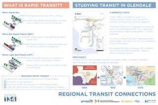
- 1. REGIONAL TRANSIT CONNECTIONS W W W. S PA C E 1 3 4 . O R G WHAT IS RAPID TRANSIT? STUDYING TRANSIT IN GLENDALE 1968 1992 2014 PC: Los Angeles County Metropolitan Transit Authority PC: Los Angeles County Metropolitan Transit Authority PC: Los Angeles County Metropolitan Transit Authority PC: Los Angeles County Metropolitan Transit Authority A rapid transit line between the San Fernando Valley, Burbank, Glendale and Pasadena has been studied for decades. For Space 134, rapid transit could be built in three phases: Frequent, all-day rapid bus Bus rapid transit with a station in the freeway median Light rail transit system with a station in the freeway median Bus signal priority over other vehicles Lower floors & fewer stops means shorter travel times by as much as 29 percent In 2014, Metro completed a study for a Countywide BRT system with the goal to improve travel time and schedule reliability. The North Hollywood to Pasadena corridor was highly recommended for BRT and a feasibility and operational design assessment is currently underway. This would connect the North Hollywood Metro Red/Orange Line Station to the City of Pasadena via the 134 Freeway. By integrating transit into Space 134, residents and visitors will receive a greater range of efficient mobility options. BRT buses have similar benefits as Rapid buses, but... BRT buses travel on a fully-dedicated right- of-way to avoid traffic congestion Uses dedicated rail lines as opposed to being confined to driving on streets Faster travel times often than Rapid buses and BRT buses Metro Rapid Bus CURRENTLY (2015) PREVIOUSLY Metro Bus Rapid Transit (BRT) Metro Light Rail Transit (LRT) BUILDING RAPID TRANSIT 1 2 3
- 2. W W W. S PA C E 1 3 4 . O R G LOCAL TRANSIT CONNECTIONS DESIGNING A MOBILITY HUB FOR SPACE 134 CONNECTING TO SPACE 134 PC: CulturalWeekly.com PC: Metropolitan Transit Authority PC: Patrick J Buckley PC: Venus Kitastojgawasic PC: GTD Aquitaine CENTRAL BRAND WHAT IS A MOBILITY HUB? BRT/LRT TO BURBANK BRT/LRT TO PASADENA Long-term: Station in freeway median under Space 134 Short-term: Stops on Goode & Sanchez by Space 134 METRO RAPID (780) TO PASADENA METRORAPID(780)TOHOLLYWOOD METRO/BEELINE LOCALBUS/SHUTTLE STOCKER WILSON BROADWAY GLENOAKS BRAND CENTRAL RE TAIL CO RE 3/4-MILE(15MINUTEWALK) NORTH Regional BRT or light rail would connect to local buses and shuttles at Space 134. MOBILITY HUB POSSIBLE LOCATION Long Beach Bikestation Electric Vehicle Parking Metro Station Under FreewayProposed North Hollywood Mobility Hub Prototype Metro Bikeshare Pod WHICH SERVICES WOULD YOU LIKE TO SEE? WHAT COULD IT LOOK LIKE? Mobility hubs are inter-modal transit stations that offer a range of transportation options for its users. The concentration of services has the benefit of seamless transferring between different modes. With the potential of rapid transit coming to Glendale, Space 134 can be designed with a mobility hub! TAP NEXT BUS 04 MIN BIKESTATION w/ bike parking, repair, rentals INFORMATIONAL KIOSK w/ trip-planning services BIKE SHARE STATION WI-FI SERVICE TRANSIT CARD SALES OUTLET ADA ACCESSIBLE RESTROOMS REAL-TIME ARRIVAL INFORMATION ELECTRIC VEHICLE w/ charging station TAXI / E-HAIL STANDS (Uber/Lyft) CAFE CARPOOLS / VANPOOLS MARKET OTHERCARSHARING SHORT-TERM SCOOTER RENTAL PICK-UP / DROP-OFF ZONES (“kiss-and-ride”) ? SPACE 134 ( = “I dislike it” = “Maybe” = “I love it!”) Not to Scale