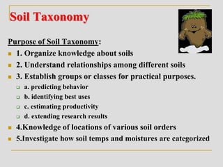
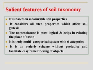
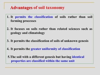
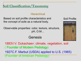
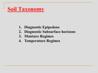
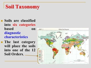
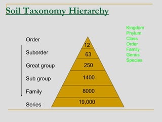
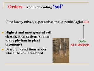
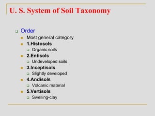
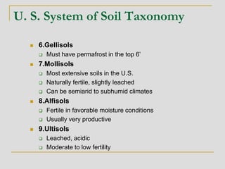
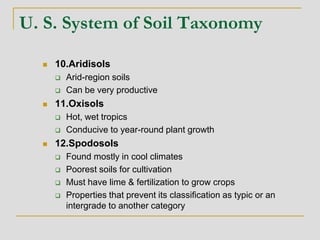
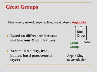
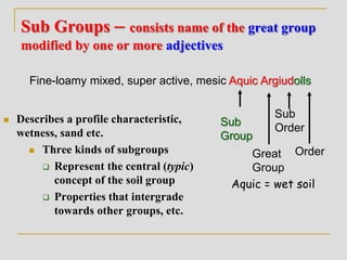
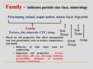
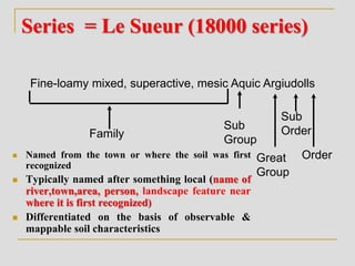
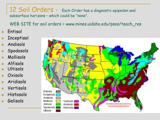
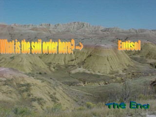
Soil classification
1. Economic 2.Physical 3. Chemical 4. Geological 5. Physiographic 6. Other types
Soil productivity
(Revenue Dept.)
Texture,
structure
Calcareous,
alkaline ,
acidic etc.,
(i) Residual/sedimentary.
(ii) Transported soils
Landscape-
Terrace soils, hilly
soils, Upland,
low land etc
OM content –
organic,
inorganic soils
Climate –
Arid,
semiarid,
humid, sub
humid soils
Vegetation-
grasslands,
forest soils
etc.,
Early systems of classification,
Soil classification- Early systems of classification, diagnostic
horizons
Soil Taxonomy
Purpose of Soil Taxonomy:
 1. Organize knowledge about soils
 2. Understand relationships among different soils
 3. Establish groups or classes for practical purposes.
 a. predicting behavior
 b. identifying best uses
 c. estimating productivity
 d. extending research results
 4.Knowledge of locations of various soil orders
 5.Investigate how soil temps and moistures are categorized
Salient features of soil taxonomy
 It is based on measurable soil properties
 It considers all such properties which affect soil
genesis
 The nomenclature is most logical & helps in relating
the place of taxon
 It is truly multi -categorical system with 6 categories
 It is an orderly scheme without prejudice and
facilitate easy remembering of objects.
Advantages of soil taxonomy
1. It permits the classification of soils rather than soil
forming processes
2. It focuses on soils rather than related sciences such as
geology and climatology
3. It permits the classification of soils of unknown genesis
4. It permits the greater uniformity of classification
5.The soil with a different genesis but having identical
properties are classified within the same unit
Soil Classification/Taxonomy
Based on soil profile characteristics and
the concept of soils as a natural body.
Observable properties: color, texture, structure,
pH, O.M…
Soil Profile
Hierarchical
Genesis
1883V.V. Dukachaev: climate, vegetation, soil
( Founder of Modern Pedology)
1927C.F. Marbut (USDA) applied to U.S. (1965)
(Founder of Ameican Pedology)
Soil Classification/Taxonomy
Second edition – 1999
USDA classification system
Soil Survey Staff 1965
Soil Taxonomy published 1975
11th edition - 2010
U. S. System of Soil Taxonomy
 Soils are named, mapped as a geologic entity or
individual
 1st taxonomic system began in 1938
 12 orders separate all soils
 Pedons are identified to help separate soil orders
(minimum 3.3 ft2, & as deep as roots grow)
Units for Soil Classification
Pedon – smallest three-dimensional unit that displays
the full range of properties /characteristic of
a given soil. (1-10 m2 of area)
- the fundamental unit of soil classification
Polypedon – group of closely associated pedons in the field
Soil Series – class of soils world-wide which share a common
suite of soil profile properties
Soil Taxonomy
1. Diagnostic Epipedons
2. Diagnostic Subsurface horizons
3. Moisture Regimes
4. Temperature Regimes
Soil Taxonomy
 Soils are classified
into six categories
based on
diagnostic
characteristics
 The last category
will place the soils
into one of the 12
Soil Orders.
Order
Suborder
Great group
Sub group
Family
Series
12
19,000
Soil Taxonomy Hierarchy
63
250
1400
8000
Kingdom
Phylum
Class
Order
Family
Genus
Species
Orders – common ending ‘sol’
 Highest and most general soil
classification system (similar
to the phylum in plant
taxonomy)
 Based on conditions under
which the soil developed
Fine-loamy mixed, super active, mesic Aquic Argiudolls
Order
oll = Mollisols
U. S. System of Soil Taxonomy
 Order
 Most general category
 1.Histosols
 Organic soils
 2.Entisols
 Undeveloped soils
 3.Inceptisols
 Slightly developed
 4.Andisols
 Volcanic material
 5.Vertisols
 Swelling-clay
U. S. System of Soil Taxonomy
 6.Gellisols
 Must have permafrost in the top 6’
 7.Mollisols
 Most extensive soils in the U.S.
 Naturally fertile, slightly leached
 Can be semiarid to subhumid climates
 8.Alfisols
 Fertile in favorable moisture conditions
 Usually very productive
 9.Ultisols
 Leached, acidic
 Moderate to low fertility
U. S. System of Soil Taxonomy
 10.Aridisols
 Arid-region soils
 Can be very productive
 11.Oxisols
 Hot, wet tropics
 Conducive to year-round plant growth
 12.Spodosols
 Found mostly in cool climates
 Poorest soils for cultivation
 Must have lime & fertilization to grow crops
 Properties that prevent its classification as typic or an
intergrade to another category
Suborders
 Grouped by similarities in soil
formation such as
 wetter/dryer soil, colder/warmer soil,
dominating effects of chemical or textural
features etc.
Fine-loamy mixed, super active, mesic Aquic Argiudolls
Sub
Order
Order
Ud = Udic Moisture
Great Groups
 Based on differences between
soil horizons & Soil features
 Accumulated clay, iron,
humus, hard pans/cement
layers
Fine-loamy mixed, superactive, mesic Aquic Argiudolls
Great
Group
Sub
Order
Order
Argi = Clay
accumulation
Sub Groups – consists name of the great group
modified by one or more adjectives
 Describes a profile characteristic,
wetness, sand etc.
 Three kinds of subgroups
 Represent the central (typic)
concept of the soil group
 Properties that intergrade
towards other groups, etc.
Great
Group
Fine-loamy mixed, super active, mesic Aquic Argiudolls
Sub
Group
Sub
Order
Order
Aquic = wet soil
Family – indicates particle size class, mineralogy
 Based on soil properties that affect management
and root penetration, such as texture, temperature,
and depth
 Behavior of soils when used for
engineering
 Important soil properties: texture,
mineralogy, pH, avg. soil temp, moisture,
permeability, thickness of horizons,
structure, consistency
Great
Group
Fine-loamy, mixed, super active, mesic Aquic Argiudolls
Family
Sub
Group
Sub
Order
Order
Texture, clay minerals, CEC, temp,
Series = Le Sueur (18000 series)
 Named from the town or where the soil was first
recognized
 Typically named after something local (name of
river,town,area, person, landscape feature near
where it is first recognized)
 Differentiated on the basis of observable &
mappable soil characteristics
Great
Group
Fine-loamy mixed, superactive, mesic Aquic Argiudolls
Family
Sub
Group
Sub
Order
Order
Diagnostics Horizons-
Used to place soils into one of the 12 Soil Orders
Surface
(9 Epipedon)
 Mollic
 Umbric
 Histic
 Ochric
 Anthropic
 Plaggen
 Melanic
 Folistic
 Grossarenic
Subsurface
(19)
• Argillic
• Natric
• Spodic
• Oxic
• Cambic
• None
Soil Taxonomy- Diagnostic Surface Horizons
(Epipedons - 9)
 1.Mollic Epipedon - thick, dark, soft,
surface layer.
Characteristics
 Mandatory for Mollisols
 Thick - greater than 18-25 cm
 High base saturation> 50%;
 Mineral soil
 Ca++ ions common
 Organic Carbon > 0.6 %
 Structure strongly developed
2.Umbric Epipedon
•Meets all criteria of the Mollic epipedon,
except base saturation < 50%
•Mountainous or hilly regions
•Chemically different than Mollic
•Moist, acidic soils where OM
decomposition slowed due to high water
table or cold temperatures
3. Ochric Epipedon
Mollic
Umbric
Ochric = pale
Value = >5.5 (dry) , >3.5 (moist)
low in O.M (<1.0%)
Structure = hard, massive when dry
•Extremely common forested and dry
soils
4.Histic Epipedon
• Mandatory for Histosol
• Formed in wet areas - water
saturated for >30 consecutive
days
• Organic materials dominate
>20 to 35% (organic horizon)
•Black to dark brown
•Low bulk density
•20-30 cm thick
5.Melanic Epipedon
•Similar in properties to Mollic
•Formed in volcanic ash
•Lightweight, Fluffy
•Properties seen in top 30 cm
•Melanic index 1.7
•OM >6%
6.Anthropic Epipedon
• Resembles Mollic but dry
(color, OM.)
• Use by humans
• Shells and bones
• Water from humans
•high in phosphorous
(due to long-term
agriculture or human activity)
7.Plaggen Epipedon
•Produced by long-term (100s yrs.) manuring
•Old, human-made surface horizon upto50cm
•Absent in U.S. system of classification.
8.Folistic Epipedon (folia – leaf)
•Saturated for <30 days
•OM : 8- 16% or more depending on
clay content of 0- 60%
9.Grossarenic Epipedon
•Sandy texture
•>100cm thick
Diagnostic Surface Horizons
Epipedons
Mollic
Umbric
Ochric
Histic
Melanic
Plaggen
Anthropic
Very common
Human-derived
“specialized”
Vegetation
established
O.M. accumulation
time
Organic Matter Accumulation
Histic
Mollic, Umbric
ochric
Parent
material
tmax = 3000 yrs
Comparison of Epipedons
Ochric Histic
Mollic
Umbric
thinner
lighter
color
more
organic
matter
low base
saturation
Diagnostic Subsurface Horizons
(Endopedons - 19)
Albic
Argillic
Spodic
Oxic
Cambic
Kandic
Sombric
Sulfuric
Spodic
Natric
Agric
Calcic
Gypsic
Salic
Duripan
Fragipan
Placic
Petrocalcic
Petrogypsic
Sub-Horizon Designations
Diagnostic Subsurface Horizons
Albic (white) endopedon
•Light-colored (Value > 6 moist, Value >4 (dry)
•Elluvial (E master horizon*)
•Low in clay, Fe and Al oxides
•Generally sandy textured
•Low chemical reactivity (low CEC)
•Typically overlies Bh or Bt horizons
albic
*not all E horizons are albic horizons
Argillic Horizon (argilla = white clay)
•Required for Alfisols, Ultisols
•Illuvial accumulation of silicate clays
•Illuvial based on overlying horizon
•clay-enriched Bt horizons
•Clay bridges, clay coatings
•Indicates a stable surface
Argillic Horizon Kandic Horizon
Activity of Clays
High Low
Illuviation of clay
Necessary Not Necessary
Natric Endopedon
same as argillic, but has either:
(1) prisms/columns in upper part,
or
(2) high Na content
Bn or Btn
Spodic Horizon (spodos = wood ash)
 Spodic - illuvial accumulation of
oxides of Al and Fe (sesquioxides)
and OM.
 red or dark red color - only found
in acid sandy soils, with high
rainfall (value, chroma < 3)
 generally found below E horizon.
Contains a Bhs or Bs horizon
 Low base saturation (acidic)
 Formes under humid acid
conditions
Oi
E
Bhs
Bs
C
Oxic horizon (oxide)
• Highly weathered (high temp. high rainfall)
•Intensively weathered horizon (Bo)
- High in Fe, Al oxides
- High in low-activity clays (Kaolinite < smectite < vermiculite)
activity
Required for Oxisols
- clay minerals are 1:1 or oxides
-residual accumulation of Al, Ti,
Fe and Mn
- Low pH not very fertile
- very old, stable surfaces
-tropical/subtropical, wet/dry climates
 Natric horizon- same as
argillic, but has either:
(1) prisms/columns in upper part,
or
(2) high Na content
 Cambic - slightly altered layer -
not weathered enough to be
argillic, Bw horizon designation
or development of color and or
structure
 NONE - no diagnostic
subsurface horizon present
Bn or Btn
Comparison of Subsurface Diagnostic
Horizons
Oxic
very
weathered
Spodic Cambic
Argillic
Natric
more Al
and Fe
less
developed
more sodium
12 Soil Orders - Each Order has a diagnostic epipedon and
subsurface horizons – which could be “none”.
WEB SITE for soil orders = www.mines.uidaho.edu/pses/teach_res
 Entisol
 Inceptisol
 Andisols
 Spodosols
 Mollisols
 Alfisols
 Ultisols
 Oxisols
 Aridisols
 Vertisols
 Histosols
 Gelisols
SOILS OF INDIA
1.Alluvial soils
2.Black soils
3.Red Soils
4.Laterite Soils
5.Coastal Sands
Alluvial Soils – 75 mha
Soil formation : parent material - river
alluvium, coastal sands and delta
alluviums
Features: 1.Texture - coarse (near
source) fine texture ( near sea/ delta)
2. mostly alkaline or acidic in reaction
3. rich in P & K but deficient in N & OM
Crops : wheat, rice, sugarcane and other
crops
Constraints:
1. Leaching (sandy) and drainage
2. intensive cultivation – deficiency of S and Zn
3. rising of ground water level
Management :
-Judicious use of irrigation water and fertilizers
-providing drainage facilities
Crops: rice, maize, wheat, Sugarcane,
tobacco, jute, oilseeds
Crops: cotton, wheat, linseed,
millets, tobacco, oilseeds,rice,
sugarcane
Extent – 74 mha
Parent material – Basalt
Semi arid- sub humid
 plain topography
Crops : Cotton, wheat, rice,
pulses, millets, tobacco, oilseeds
Extent: 70 mha
AP – 27.4 mha
Other names :
red loams,
red earths,
red & yellow soils
Climate :
hot Semi arid, humid
sub tropical
Extent: 25 mha
Climate : sub
tropical to tropical ,
higher topography
Constraints:
high permeability,
low AWC, High P-
fixation,
Al & Mn toxicity,
strongly acidic
Humus content of the soil
is low, microorganisms like
bacteria, get destroyed due to
high temperature.
Coastal Sands
Present all along coast 3 to 12 km away on both east and west
coast
Parent material : Marine sediments
Properties:
1. Deep to very deep
2. Ground water at 2 to 5 m depth
3.Brackish water, saline in reaction
4.sandy texture with less clay content
5.Light soils, more permeability, low WHC
6. low OM, low CEC and Base saturation and less
fertile.
Land use - Doruvu technology water management
Constraints – during cyclone – inundated due to tidal over
flow
soil orders.ppt
soil orders.ppt

soil orders.ppt

  • 1.
    Soil classification 1. Economic2.Physical 3. Chemical 4. Geological 5. Physiographic 6. Other types Soil productivity (Revenue Dept.) Texture, structure Calcareous, alkaline , acidic etc., (i) Residual/sedimentary. (ii) Transported soils Landscape- Terrace soils, hilly soils, Upland, low land etc OM content – organic, inorganic soils Climate – Arid, semiarid, humid, sub humid soils Vegetation- grasslands, forest soils etc., Early systems of classification, Soil classification- Early systems of classification, diagnostic horizons
  • 2.
    Soil Taxonomy Purpose ofSoil Taxonomy:  1. Organize knowledge about soils  2. Understand relationships among different soils  3. Establish groups or classes for practical purposes.  a. predicting behavior  b. identifying best uses  c. estimating productivity  d. extending research results  4.Knowledge of locations of various soil orders  5.Investigate how soil temps and moistures are categorized
  • 3.
    Salient features ofsoil taxonomy  It is based on measurable soil properties  It considers all such properties which affect soil genesis  The nomenclature is most logical & helps in relating the place of taxon  It is truly multi -categorical system with 6 categories  It is an orderly scheme without prejudice and facilitate easy remembering of objects.
  • 4.
    Advantages of soiltaxonomy 1. It permits the classification of soils rather than soil forming processes 2. It focuses on soils rather than related sciences such as geology and climatology 3. It permits the classification of soils of unknown genesis 4. It permits the greater uniformity of classification 5.The soil with a different genesis but having identical properties are classified within the same unit
  • 5.
    Soil Classification/Taxonomy Based onsoil profile characteristics and the concept of soils as a natural body. Observable properties: color, texture, structure, pH, O.M… Soil Profile Hierarchical Genesis 1883V.V. Dukachaev: climate, vegetation, soil ( Founder of Modern Pedology) 1927C.F. Marbut (USDA) applied to U.S. (1965) (Founder of Ameican Pedology)
  • 6.
    Soil Classification/Taxonomy Second edition– 1999 USDA classification system Soil Survey Staff 1965 Soil Taxonomy published 1975 11th edition - 2010
  • 7.
    U. S. Systemof Soil Taxonomy  Soils are named, mapped as a geologic entity or individual  1st taxonomic system began in 1938  12 orders separate all soils  Pedons are identified to help separate soil orders (minimum 3.3 ft2, & as deep as roots grow)
  • 8.
    Units for SoilClassification Pedon – smallest three-dimensional unit that displays the full range of properties /characteristic of a given soil. (1-10 m2 of area) - the fundamental unit of soil classification Polypedon – group of closely associated pedons in the field Soil Series – class of soils world-wide which share a common suite of soil profile properties
  • 9.
    Soil Taxonomy 1. DiagnosticEpipedons 2. Diagnostic Subsurface horizons 3. Moisture Regimes 4. Temperature Regimes
  • 10.
    Soil Taxonomy  Soilsare classified into six categories based on diagnostic characteristics  The last category will place the soils into one of the 12 Soil Orders.
  • 11.
    Order Suborder Great group Sub group Family Series 12 19,000 SoilTaxonomy Hierarchy 63 250 1400 8000 Kingdom Phylum Class Order Family Genus Species
  • 12.
    Orders – commonending ‘sol’  Highest and most general soil classification system (similar to the phylum in plant taxonomy)  Based on conditions under which the soil developed Fine-loamy mixed, super active, mesic Aquic Argiudolls Order oll = Mollisols
  • 13.
    U. S. Systemof Soil Taxonomy  Order  Most general category  1.Histosols  Organic soils  2.Entisols  Undeveloped soils  3.Inceptisols  Slightly developed  4.Andisols  Volcanic material  5.Vertisols  Swelling-clay
  • 14.
    U. S. Systemof Soil Taxonomy  6.Gellisols  Must have permafrost in the top 6’  7.Mollisols  Most extensive soils in the U.S.  Naturally fertile, slightly leached  Can be semiarid to subhumid climates  8.Alfisols  Fertile in favorable moisture conditions  Usually very productive  9.Ultisols  Leached, acidic  Moderate to low fertility
  • 15.
    U. S. Systemof Soil Taxonomy  10.Aridisols  Arid-region soils  Can be very productive  11.Oxisols  Hot, wet tropics  Conducive to year-round plant growth  12.Spodosols  Found mostly in cool climates  Poorest soils for cultivation  Must have lime & fertilization to grow crops  Properties that prevent its classification as typic or an intergrade to another category
  • 16.
    Suborders  Grouped bysimilarities in soil formation such as  wetter/dryer soil, colder/warmer soil, dominating effects of chemical or textural features etc. Fine-loamy mixed, super active, mesic Aquic Argiudolls Sub Order Order Ud = Udic Moisture
  • 17.
    Great Groups  Basedon differences between soil horizons & Soil features  Accumulated clay, iron, humus, hard pans/cement layers Fine-loamy mixed, superactive, mesic Aquic Argiudolls Great Group Sub Order Order Argi = Clay accumulation
  • 18.
    Sub Groups –consists name of the great group modified by one or more adjectives  Describes a profile characteristic, wetness, sand etc.  Three kinds of subgroups  Represent the central (typic) concept of the soil group  Properties that intergrade towards other groups, etc. Great Group Fine-loamy mixed, super active, mesic Aquic Argiudolls Sub Group Sub Order Order Aquic = wet soil
  • 19.
    Family – indicatesparticle size class, mineralogy  Based on soil properties that affect management and root penetration, such as texture, temperature, and depth  Behavior of soils when used for engineering  Important soil properties: texture, mineralogy, pH, avg. soil temp, moisture, permeability, thickness of horizons, structure, consistency Great Group Fine-loamy, mixed, super active, mesic Aquic Argiudolls Family Sub Group Sub Order Order Texture, clay minerals, CEC, temp,
  • 20.
    Series = LeSueur (18000 series)  Named from the town or where the soil was first recognized  Typically named after something local (name of river,town,area, person, landscape feature near where it is first recognized)  Differentiated on the basis of observable & mappable soil characteristics Great Group Fine-loamy mixed, superactive, mesic Aquic Argiudolls Family Sub Group Sub Order Order
  • 21.
    Diagnostics Horizons- Used toplace soils into one of the 12 Soil Orders Surface (9 Epipedon)  Mollic  Umbric  Histic  Ochric  Anthropic  Plaggen  Melanic  Folistic  Grossarenic Subsurface (19) • Argillic • Natric • Spodic • Oxic • Cambic • None
  • 22.
    Soil Taxonomy- DiagnosticSurface Horizons (Epipedons - 9)  1.Mollic Epipedon - thick, dark, soft, surface layer. Characteristics  Mandatory for Mollisols  Thick - greater than 18-25 cm  High base saturation> 50%;  Mineral soil  Ca++ ions common  Organic Carbon > 0.6 %  Structure strongly developed
  • 23.
    2.Umbric Epipedon •Meets allcriteria of the Mollic epipedon, except base saturation < 50% •Mountainous or hilly regions •Chemically different than Mollic •Moist, acidic soils where OM decomposition slowed due to high water table or cold temperatures
  • 24.
    3. Ochric Epipedon Mollic Umbric Ochric= pale Value = >5.5 (dry) , >3.5 (moist) low in O.M (<1.0%) Structure = hard, massive when dry •Extremely common forested and dry soils
  • 25.
    4.Histic Epipedon • Mandatoryfor Histosol • Formed in wet areas - water saturated for >30 consecutive days • Organic materials dominate >20 to 35% (organic horizon) •Black to dark brown •Low bulk density •20-30 cm thick
  • 26.
    5.Melanic Epipedon •Similar inproperties to Mollic •Formed in volcanic ash •Lightweight, Fluffy •Properties seen in top 30 cm •Melanic index 1.7 •OM >6%
  • 27.
    6.Anthropic Epipedon • ResemblesMollic but dry (color, OM.) • Use by humans • Shells and bones • Water from humans •high in phosphorous (due to long-term agriculture or human activity)
  • 28.
    7.Plaggen Epipedon •Produced bylong-term (100s yrs.) manuring •Old, human-made surface horizon upto50cm •Absent in U.S. system of classification.
  • 29.
    8.Folistic Epipedon (folia– leaf) •Saturated for <30 days •OM : 8- 16% or more depending on clay content of 0- 60% 9.Grossarenic Epipedon •Sandy texture •>100cm thick
  • 30.
  • 31.
    Vegetation established O.M. accumulation time Organic MatterAccumulation Histic Mollic, Umbric ochric Parent material tmax = 3000 yrs
  • 32.
    Comparison of Epipedons OchricHistic Mollic Umbric thinner lighter color more organic matter low base saturation
  • 33.
    Diagnostic Subsurface Horizons (Endopedons- 19) Albic Argillic Spodic Oxic Cambic Kandic Sombric Sulfuric Spodic Natric Agric Calcic Gypsic Salic Duripan Fragipan Placic Petrocalcic Petrogypsic Sub-Horizon Designations
  • 34.
    Diagnostic Subsurface Horizons Albic(white) endopedon •Light-colored (Value > 6 moist, Value >4 (dry) •Elluvial (E master horizon*) •Low in clay, Fe and Al oxides •Generally sandy textured •Low chemical reactivity (low CEC) •Typically overlies Bh or Bt horizons albic *not all E horizons are albic horizons
  • 35.
    Argillic Horizon (argilla= white clay) •Required for Alfisols, Ultisols •Illuvial accumulation of silicate clays •Illuvial based on overlying horizon •clay-enriched Bt horizons •Clay bridges, clay coatings •Indicates a stable surface Argillic Horizon Kandic Horizon Activity of Clays High Low Illuviation of clay Necessary Not Necessary
  • 36.
    Natric Endopedon same asargillic, but has either: (1) prisms/columns in upper part, or (2) high Na content Bn or Btn
  • 37.
    Spodic Horizon (spodos= wood ash)  Spodic - illuvial accumulation of oxides of Al and Fe (sesquioxides) and OM.  red or dark red color - only found in acid sandy soils, with high rainfall (value, chroma < 3)  generally found below E horizon. Contains a Bhs or Bs horizon  Low base saturation (acidic)  Formes under humid acid conditions Oi E Bhs Bs C
  • 38.
    Oxic horizon (oxide) •Highly weathered (high temp. high rainfall) •Intensively weathered horizon (Bo) - High in Fe, Al oxides - High in low-activity clays (Kaolinite < smectite < vermiculite) activity Required for Oxisols - clay minerals are 1:1 or oxides -residual accumulation of Al, Ti, Fe and Mn - Low pH not very fertile - very old, stable surfaces -tropical/subtropical, wet/dry climates
  • 39.
     Natric horizon-same as argillic, but has either: (1) prisms/columns in upper part, or (2) high Na content  Cambic - slightly altered layer - not weathered enough to be argillic, Bw horizon designation or development of color and or structure  NONE - no diagnostic subsurface horizon present Bn or Btn
  • 40.
    Comparison of SubsurfaceDiagnostic Horizons Oxic very weathered Spodic Cambic Argillic Natric more Al and Fe less developed more sodium
  • 41.
    12 Soil Orders- Each Order has a diagnostic epipedon and subsurface horizons – which could be “none”. WEB SITE for soil orders = www.mines.uidaho.edu/pses/teach_res  Entisol  Inceptisol  Andisols  Spodosols  Mollisols  Alfisols  Ultisols  Oxisols  Aridisols  Vertisols  Histosols  Gelisols
  • 42.
    SOILS OF INDIA 1.Alluvialsoils 2.Black soils 3.Red Soils 4.Laterite Soils 5.Coastal Sands
  • 43.
    Alluvial Soils –75 mha Soil formation : parent material - river alluvium, coastal sands and delta alluviums Features: 1.Texture - coarse (near source) fine texture ( near sea/ delta) 2. mostly alkaline or acidic in reaction 3. rich in P & K but deficient in N & OM Crops : wheat, rice, sugarcane and other crops Constraints: 1. Leaching (sandy) and drainage 2. intensive cultivation – deficiency of S and Zn 3. rising of ground water level Management : -Judicious use of irrigation water and fertilizers -providing drainage facilities
  • 44.
    Crops: rice, maize,wheat, Sugarcane, tobacco, jute, oilseeds
  • 45.
    Crops: cotton, wheat,linseed, millets, tobacco, oilseeds,rice, sugarcane Extent – 74 mha Parent material – Basalt Semi arid- sub humid  plain topography
  • 46.
    Crops : Cotton,wheat, rice, pulses, millets, tobacco, oilseeds Extent: 70 mha AP – 27.4 mha Other names : red loams, red earths, red & yellow soils Climate : hot Semi arid, humid sub tropical
  • 47.
    Extent: 25 mha Climate: sub tropical to tropical , higher topography Constraints: high permeability, low AWC, High P- fixation, Al & Mn toxicity, strongly acidic
  • 48.
    Humus content ofthe soil is low, microorganisms like bacteria, get destroyed due to high temperature.
  • 49.
    Coastal Sands Present allalong coast 3 to 12 km away on both east and west coast Parent material : Marine sediments Properties: 1. Deep to very deep 2. Ground water at 2 to 5 m depth 3.Brackish water, saline in reaction 4.sandy texture with less clay content 5.Light soils, more permeability, low WHC 6. low OM, low CEC and Base saturation and less fertile. Land use - Doruvu technology water management Constraints – during cyclone – inundated due to tidal over flow