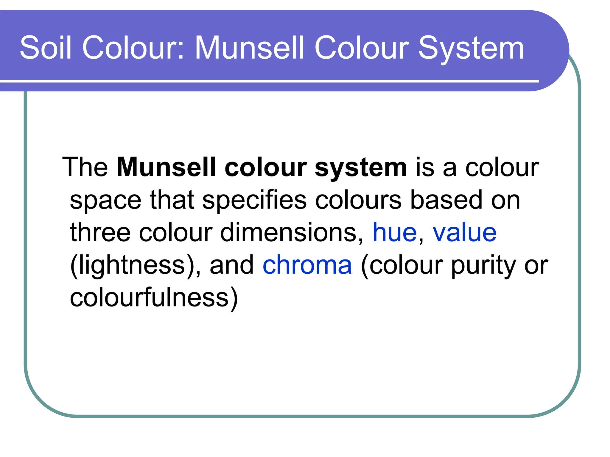
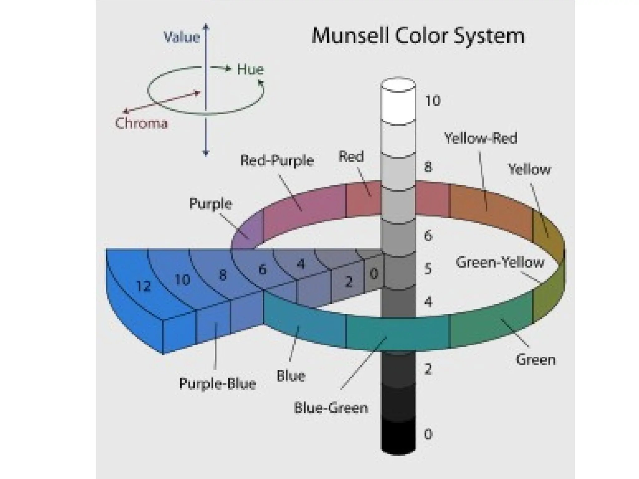
Soil Colour: MunsellColour System
The Munsell colour system is a colour
space that specifies colours based on
three colour dimensions, hue, value
(lightness), and chroma (colour purity or
colourfulness)
2.
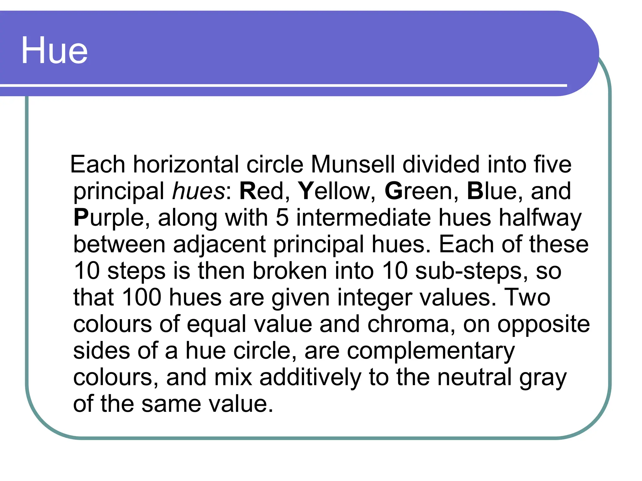
Hue
Each horizontal circleMunsell divided into five
principal hues: Red, Yellow, Green, Blue, and
Purple, along with 5 intermediate hues halfway
between adjacent principal hues. Each of these
10 steps is then broken into 10 sub-steps, so
that 100 hues are given integer values. Two
colours of equal value and chroma, on opposite
sides of a hue circle, are complementary
colours, and mix additively to the neutral gray
of the same value.
4.
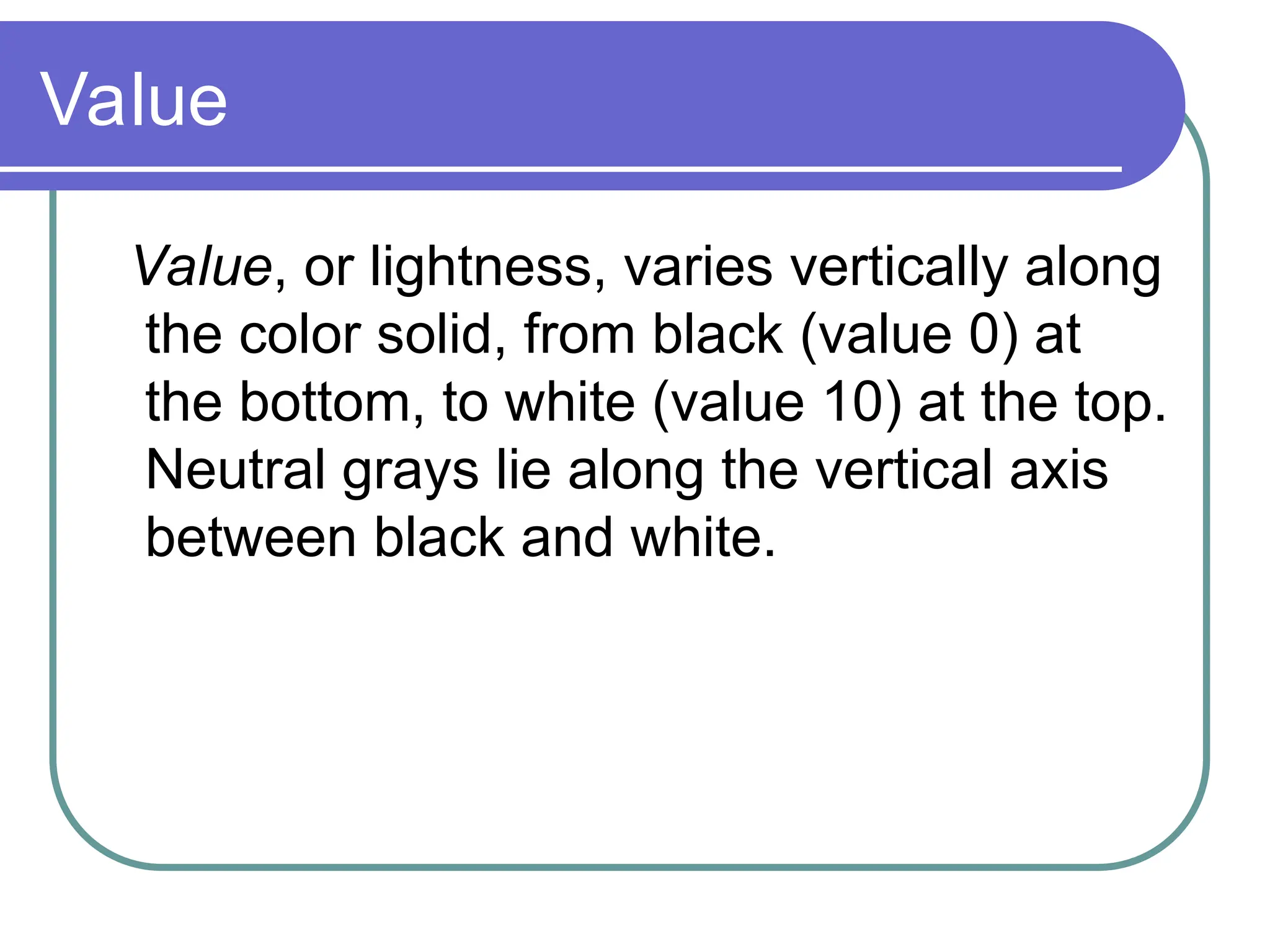
Value
Value, or lightness,varies vertically along
the color solid, from black (value 0) at
the bottom, to white (value 10) at the top.
Neutral grays lie along the vertical axis
between black and white.
5.
Chroma
Chroma, measured radiallyfrom the center of
each slice, represents the “purity” of a colour,
with lower chroma being less pure (more
washed out, as in pastels). Note that there is
no intrinsic upper limit to chroma. Different
areas of the color space have different
maximal chroma coordinates. For instance
light yellow colours have considerably more
potential chroma than light purples, due to the
nature of the eye and the physics of colour
stimuli.
6.
Specifying a colour
A color is fully specified by listing the three
numbers for hue, value, and chroma. For
instance, a fairly saturated purple of medium
lightness would be 5P 5/10 with 5P meaning
the color in the middle of the purple hue band,
5/ meaning medium lightness, and a chroma
of 10.
5P 5/10
7.
SOIL CLASSIFICATION
Soil classificationdeals with the
systematic categorization of soils based
on distinguishing characteristics as well
as criteria that dictate choices in use.
8.
Engineering Classification
Geotechnical engineersclassify soils
according to their engineering properties
as they relate to use for foundation
support or building material. Modern
engineering classification systems are
designed to allow an easy transition from
field observations to basic predictions of
soil engineering properties and
behaviors.
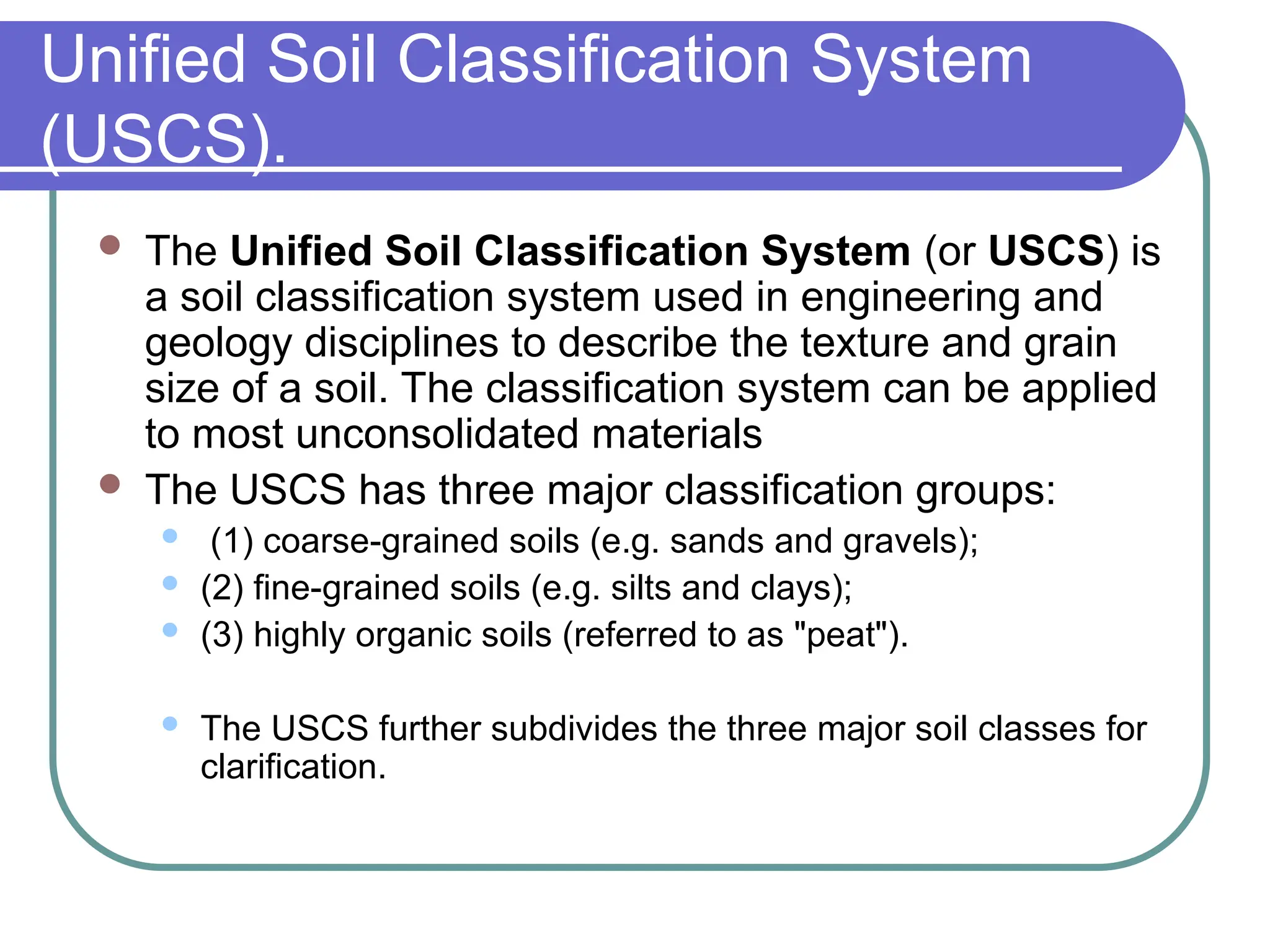
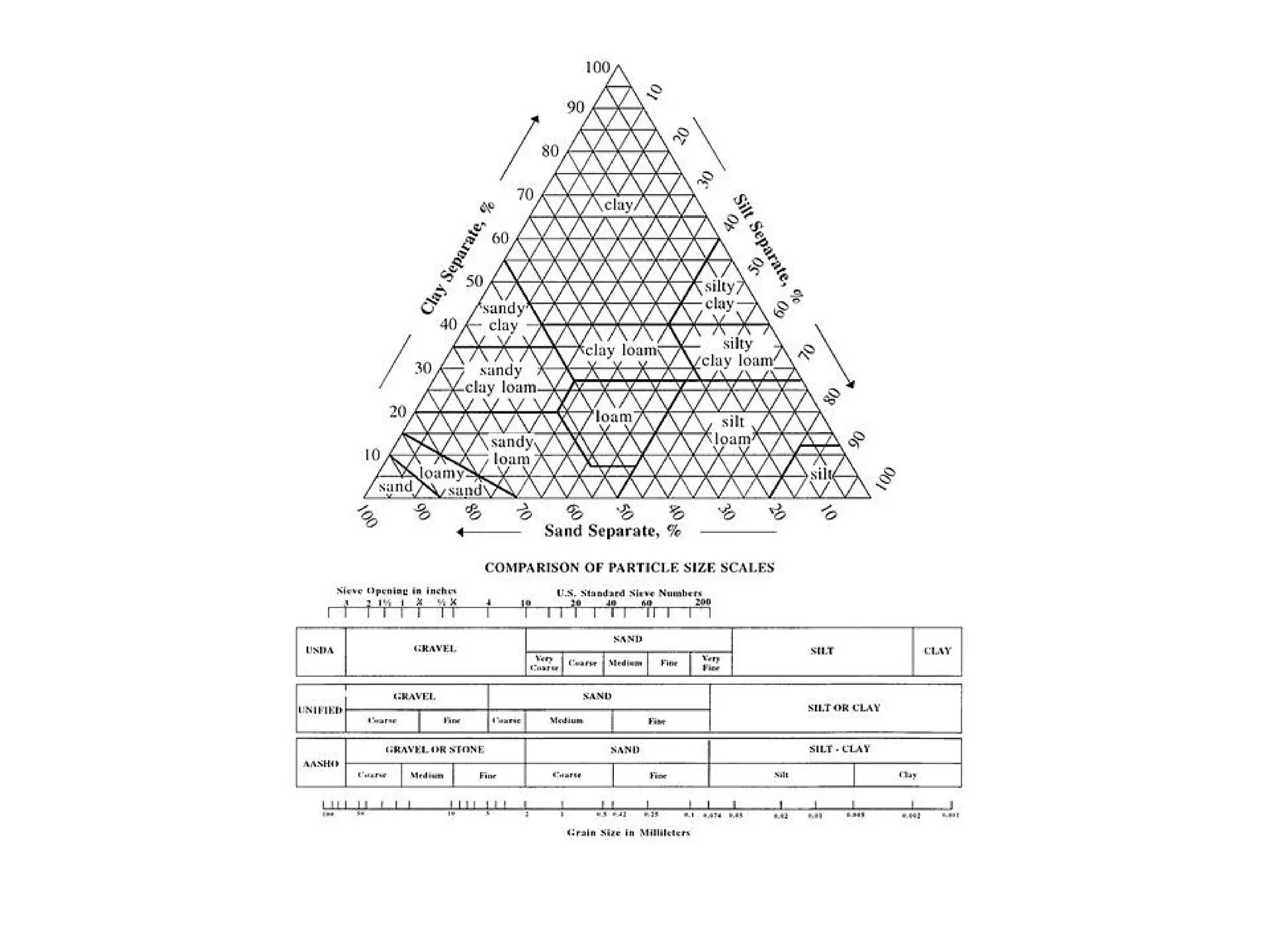
Unified Soil ClassificationSystem
(USCS).
The Unified Soil Classification System (or USCS) is
a soil classification system used in engineering and
geology disciplines to describe the texture and grain
size of a soil. The classification system can be applied
to most unconsolidated materials
The USCS has three major classification groups:
(1) coarse-grained soils (e.g. sands and gravels);
(2) fine-grained soils (e.g. silts and clays);
(3) highly organic soils (referred to as "peat").
The USCS further subdivides the three major soil classes for
clarification.
12.
Soil Science
For soilresources, experience has
shown that a natural system approach to
classification, i.e. grouping soils by their
intrinsic property (soil morphology),
behaviour, or genesis, results in classes
that can be interpreted for many diverse
uses.
13.
USDA Soil Taxonomy
Usestaxonomic criteria involving soil
morphology and laboratory tests to
inform and refine hierarchical classes.
World Reference Basefor Soil
Resources (WRB)
The World Reference Base for Soil
Resources (WRB) is the international
standard taxonomic soil classification system
endorsed by the International Union of Soil
Sciences (IUSS). It was developed by an
international collaboration coordinated by the
International Soil Reference and Information
Centre (ISRIC) and sponsored by the IUSS
and the FAO via its Land & Water
Development division. It replaces the previous
FAO soil classification.
16.
WRB
The WRBborrows heavily from modern soil
classification concepts, including USDA soil
taxonomy, the legend for the FAO Soil Map of
the World 1988, the Référentiel Pédologique
and Russian concepts. The classification is
based mainly on soil morphology as an
expression of pedogenesis. A major difference
with USDA soil taxonomy is that soil climate is
not part of the system, except insofar as
climate influences soil profile characteristics.
17.
WRB 98 soilgroups
Examples of the WRB soil groups are:
Acrisol,Arenosol, Chernozem, Cryosol,
Durisol, Ferralsol, Gleysol, Gypsisol,
Histosol, Lixisol, Podzol, Solonchak,
Solonetz, Umbrisol, Vertisol
Diagnostic horizon: epipedon
OchricEpipedon
The ochric epipedon fails to meet the definitions for any of the other seven
epipedons because it is too thin or too dry, has too high a color value or chroma,
contains too little organic carbon, has too high an n value or melanic index, or is
both massive and hard or harder when dry . Many ochric epipedons have either a
Munsell color value of 4 or more, moist, and 6 or more, dry, or chroma of 4 or
more, or they include an A or Ap horizon that has both low color values and low
chroma but is too thin to be recognized as a mollic or umbric epipedon (and has
less than 15 percent calcium carbonate equivalent in the fine-earth fraction).
Ochric epipedons also include horizons of organic materials that are too thin to
meet the requirements for a histic or folistic epipedon.
The ochric epipedon includes eluvial horizons that are at or near the soil surface,
and it extends to the first underlying diagnostic illuvial horizon (defined below as
an argillic, kandic, natric, or spodic horizon). If the underlying horizon is a B
horizon of alteration (defined below as a cambic or oxic horizon) and there is no
surface horizon that is appreciably darkened by humus, the lower limit of the
ochric epipedon is the lower boundary of the plow layer or an equivalent depth (18
cm) in a soil that has not been plowed. Actually, the same horizon in an unplowed
soil may be both part of the epipedon and part of the cambic horizon; the ochric
epipedon and the subsurface diagnostic horizons are not all mutually exclusive.
The ochric epipedon does not have rock structure and does not include finely
stratified fresh sediments, nor can it be an Ap horizon directly overlying such
deposits.
21.
Diagnostic horizon: subsurface
KandicHorizon
Is a vertically continuous subsurface horizon that underlies a coarser textured surface horizon. The minimum thickness of the
surface horizon is 18 cm after mixing or 5 cm if the textural transition to the kandic horizon is abrupt and there is no densic, lithic,
paralithic, or petroferric contact (defined below) within 50 cm of the mineral soil surface; and
Has its upper boundary:
At the point where the clay percentage in the fine-earth fraction, increasing with depth within a vertical distance of 15 cm or
less, is either:
4 percent or more (absolute) higher than that in the surface horizon if that horizon has less than 20 percent total clay
in the fine-earth fraction; or
20 percent or more (relative) higher than that in the surface horizon if that horizon has 20 to 40 percent total clay in
the fine-earth fraction; or
8 percent or more (absolute) higher than that in the surface horizon if that horizon has more than 40 percent total clay
in the fine-earth fraction; and
At a depth:
Between 100 cm and 200 cm from the mineral soil surface if the particle-size class is sandy or sandy-skeletal
throughout the upper 100 cm; or
Within 100 cm from the mineral soil surface if the clay content in the fine-earth fraction of the surface horizon is 20
percent or more; or
Within 125 cm from the mineral soil surface for all other soils; and
Has a thickness of either:
30 cm or more; or
15 cm or more if there is a densic, lithic, paralithic, or petroferric contact within 50 cm of the mineral soil surface and the
kandic horizon constitutes 60 percent or more of the vertical distance between a depth of 18 cm and the contact; and
Has a texture of loamy very fine sand or finer; and
Has an apparent CEC of 16 cmol(+) or less per kg clay (by 1N NH4OAc pH 7) and an apparent ECEC of 12 cmol(+) or less per kg
clay (sum of bases extracted with 1N NH4OAc pH 7 plus 1N KCl-extractable Al) in 50 percent or more of its thickness between the
point where the clay increase requirements are met and either a depth of 100 cm below that point or a densic, lithic, paralithic, or
petroferric contact if shallower. (The percentage of clay is either measured by the pipette method or estimated to be 2.5 times
[percent water retained at 1500 kPa tension minus percent organic carbon], whichever is higher, but no more than 100); and
Has a regular decrease in organic-carbon content with increasing depth, no fine stratification, and no overlying layers more than 30
cm thick that have fine stratification and/or an organic-carbon content that decreases irregularly with increasing depth.
23.
Gelisols
Gelisols aresoils of very cold climates that
contain permafrost within 2 meters of the
surface. These soils are limited geographically
to the high-latitude polar regions and localized
areas at high mountain elevations. They show
relatively little morphological development. Low
soil temperatures cause soil-forming processes
such as decomposition of organic materials to
proceed very slowly. As a result, Gelisols store
large quantities of organic carbon
24.
Histosols
Histosols aresoils that are composed mainly of organic materials.
They contain at least 20-30% organic matter by weight and are
more than 40 cm thick. Bulk densities are quite low, often less than
0.3 gcm-3
.
Most Histosols form in settings such as wetlands where restricted
drainage inhibits the decomposition of plant and animal remains,
allowing these organic materials to accumulate over time. As a
result, Histosols are ecologically important because of the large
quantities of carbon they contain. These soils occupy ~1.2% of the
ice-free land area globally. Histosols are often referred to as peats
and mucks and have physical properties that restrict their use for
engineering purposes. These include low weight-bearing capacity
and subsidence when drained. They are mined for fuel and
horticultural products.
Histosols are divided into 4 suborders: Folists, Fibrists, Saprists,
and Hemists.
25.
Spodosols
Spodosols areacid soils characterized by a subsurface
accumulation of humus that is complexed with Al and Fe.
These photogenic soils typically form in coarse-textured
parent material and have a light-colored E horizon
overlying a reddish-brown spodic horizon. The process
that forms these horizons is known as podzolization.
Spodosols often occur under coniferous forest in cool,
moist climates. Globally, they occupy ~4% of the ice-free
land area.
Many Spodosols support forest. Because they are
naturally infertile, Spodosols require additions of lime in
order to be productive agriculturally.
Spodosols are divided into 5 suborders: Aquods, Gelods,
Cryods, Humods, and Orthods.
26.
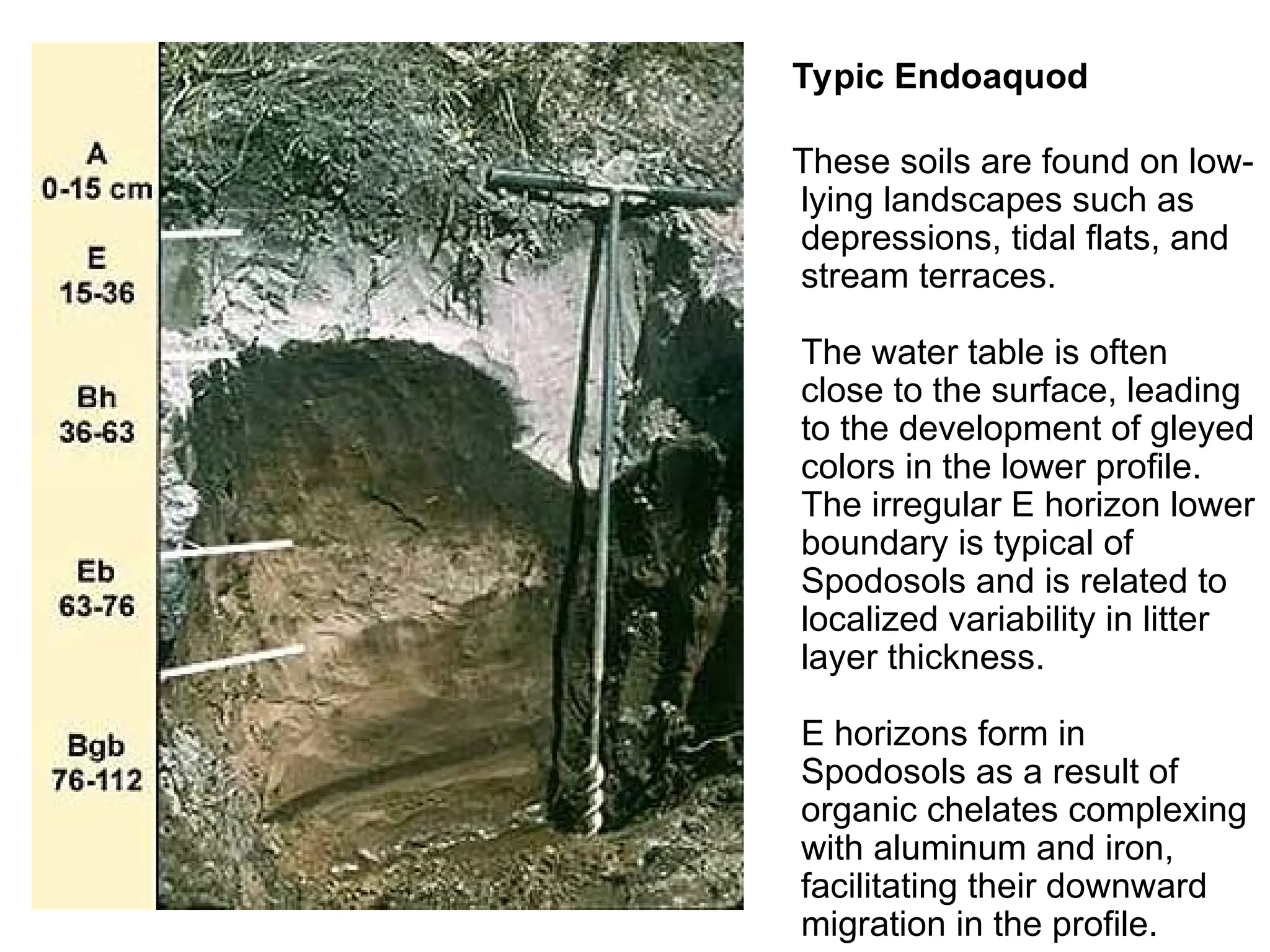
Typic Endoaquod
These soilsare found on low-
lying landscapes such as
depressions, tidal flats, and
stream terraces.
The water table is often
close to the surface, leading
to the development of gleyed
colors in the lower profile.
The irregular E horizon lower
boundary is typical of
Spodosols and is related to
localized variability in litter
layer thickness.
E horizons form in
Spodosols as a result of
organic chelates complexing
with aluminum and iron,
facilitating their downward
migration in the profile.
28.
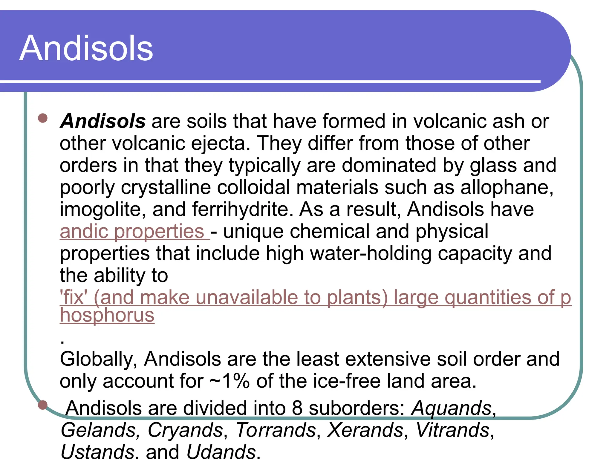
Andisols
Andisols aresoils that have formed in volcanic ash or
other volcanic ejecta. They differ from those of other
orders in that they typically are dominated by glass and
poorly crystalline colloidal materials such as allophane,
imogolite, and ferrihydrite. As a result, Andisols have
andic properties - unique chemical and physical
properties that include high water-holding capacity and
the ability to
'fix' (and make unavailable to plants) large quantities of p
hosphorus
.
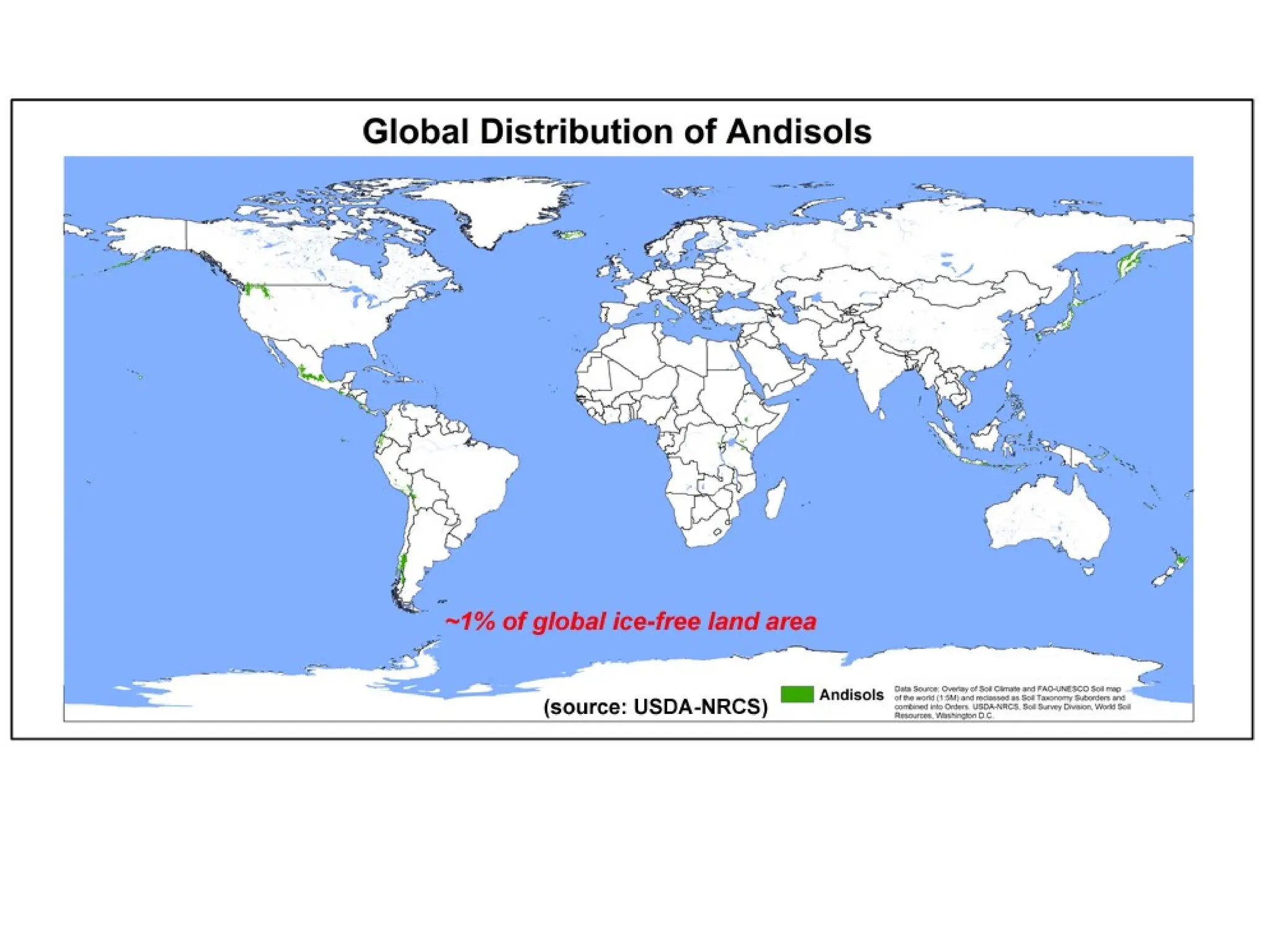
Globally, Andisols are the least extensive soil order and
only account for ~1% of the ice-free land area.
Andisols are divided into 8 suborders: Aquands,
Gelands, Cryands, Torrands, Xerands, Vitrands,
Ustands, and Udands.
29.
Hydrous, amorphic,
isothermic Acrudoxic
Hydrudand
Inthe upper 250 cm of this
soil, alternating A and B
horizons have formed as a
result of ash falls and
intermittent soil development
cycles. White specks in the C
horizon are gibbsite (Al[OH]3)
coatings. The 15-bar H2O
content ranges from 102-
211% in this soil. These soils
have very low cation
exchange capacity, <2.0
cmol(+)/kg.
31.
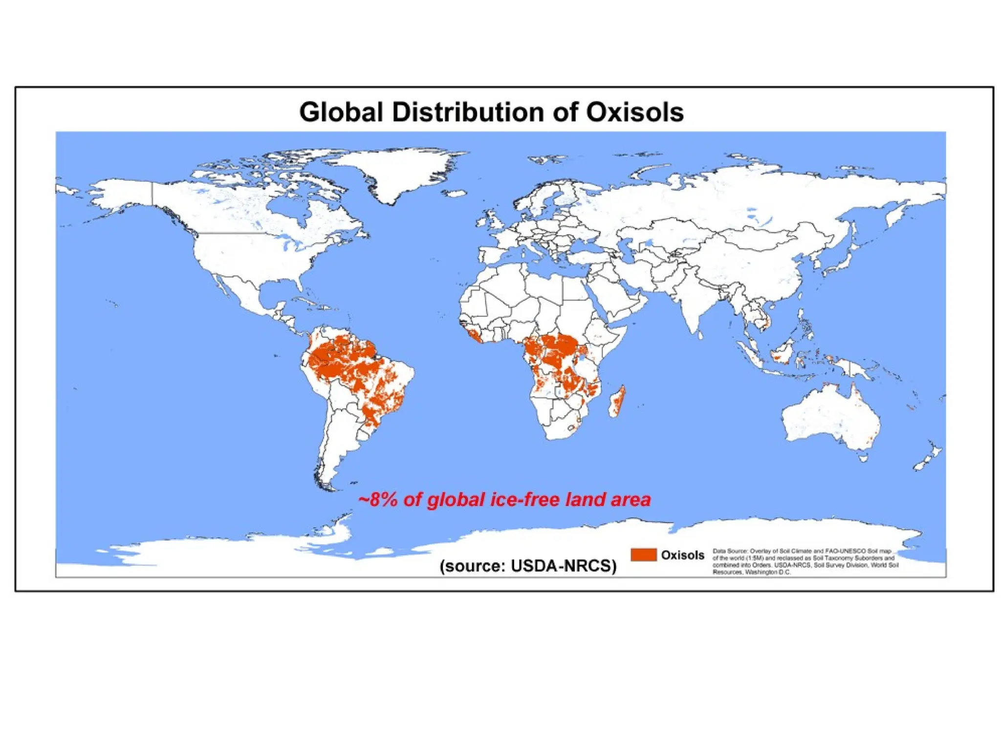
Oxisols
Oxisols arevery highly weathered soils that are found primarily
in the intertropical regions of the world. These soils contain few
weatherable minerals and are often rich in Fe and Al oxide
minerals.
Oxisols occupy ~7.5% of the global ice-free land area.
are restricted to Hawaii.
Most of these soils are characterized by extremely low native
fertility, resulting from very low nutrient reserves, high
phosphorus retention by oxide minerals, and low cation exchange
capacity (CEC). Most nutrients in Oxisol ecosystems are
contained in the standing vegetation and decomposing plant
material. Despite low fertility, Oxisols can be quite productive with
inputs of lime and fertilizers.
Oxisols are divided into 5 suborders: Aquox, Torrox, Ustox,
Perox, and Udox.
32.
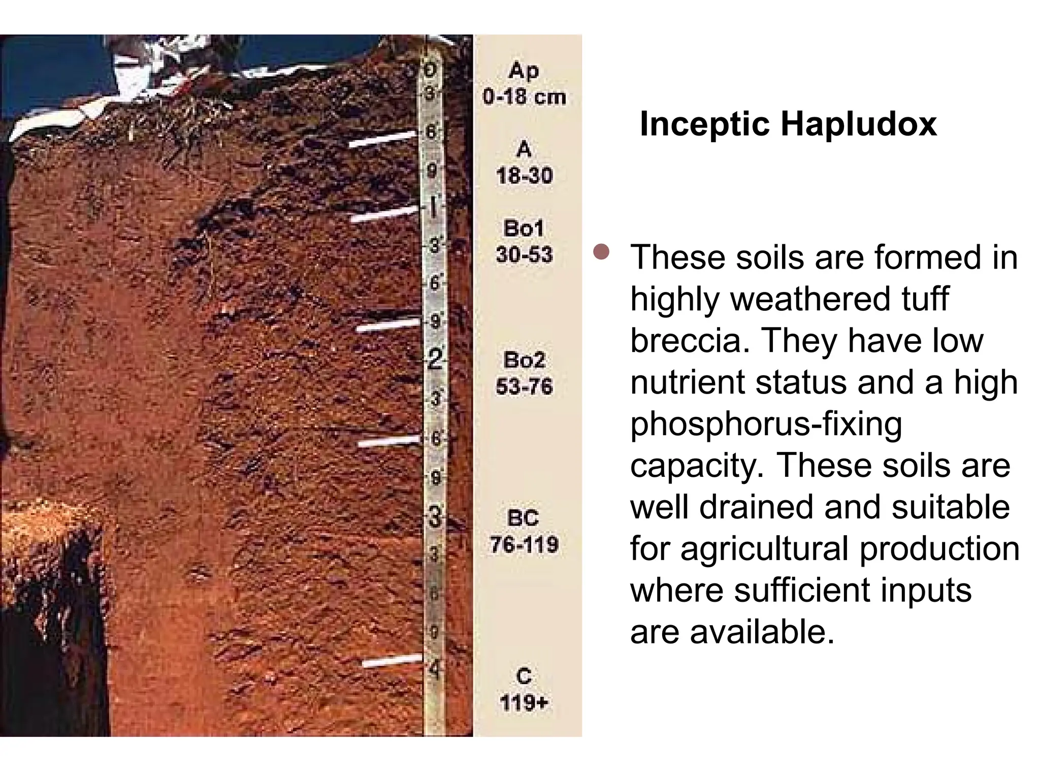
Inceptic Hapludox
Thesesoils are formed in
highly weathered tuff
breccia. They have low
nutrient status and a high
phosphorus-fixing
capacity. These soils are
well drained and suitable
for agricultural production
where sufficient inputs
are available.
34.
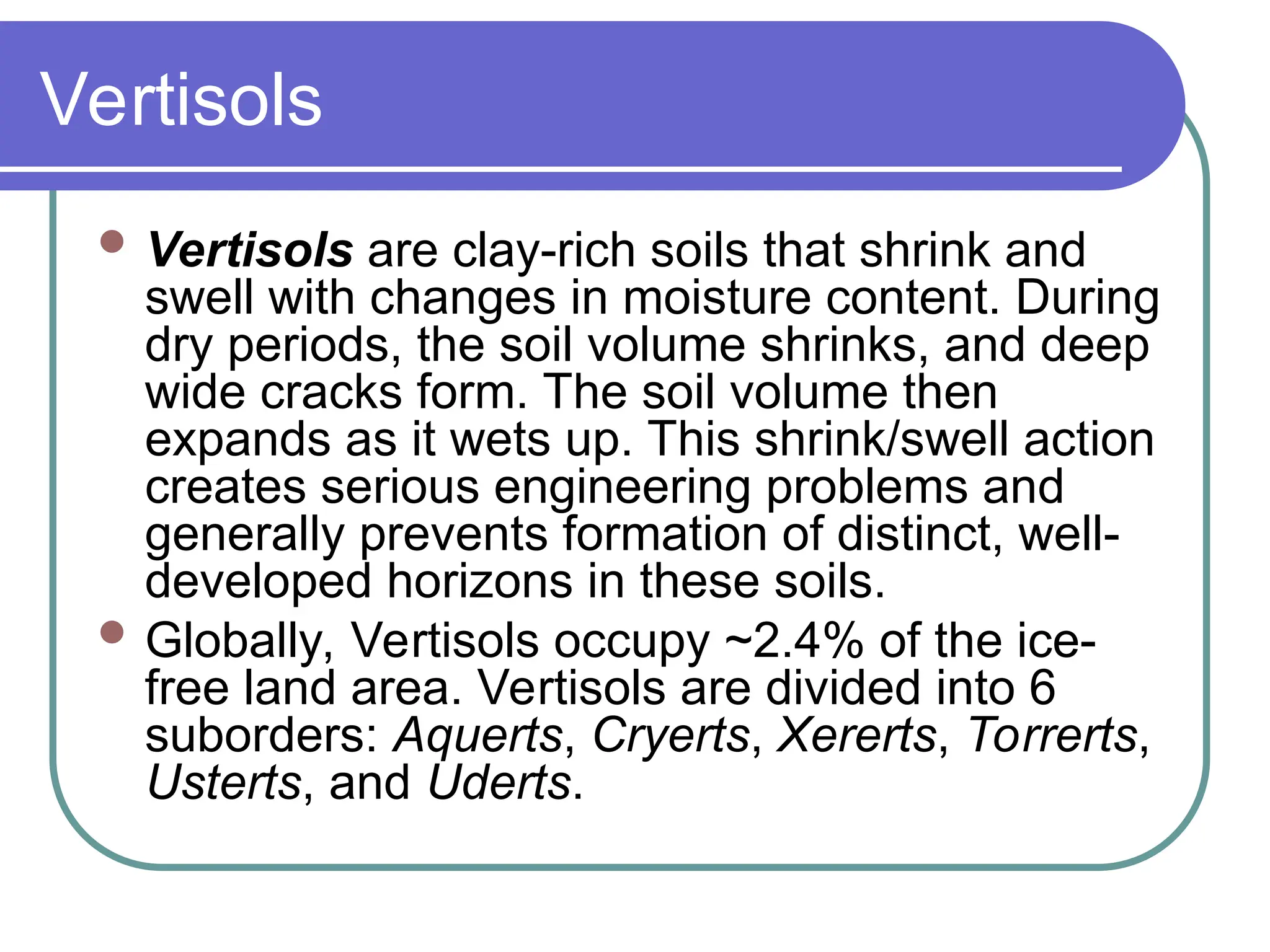
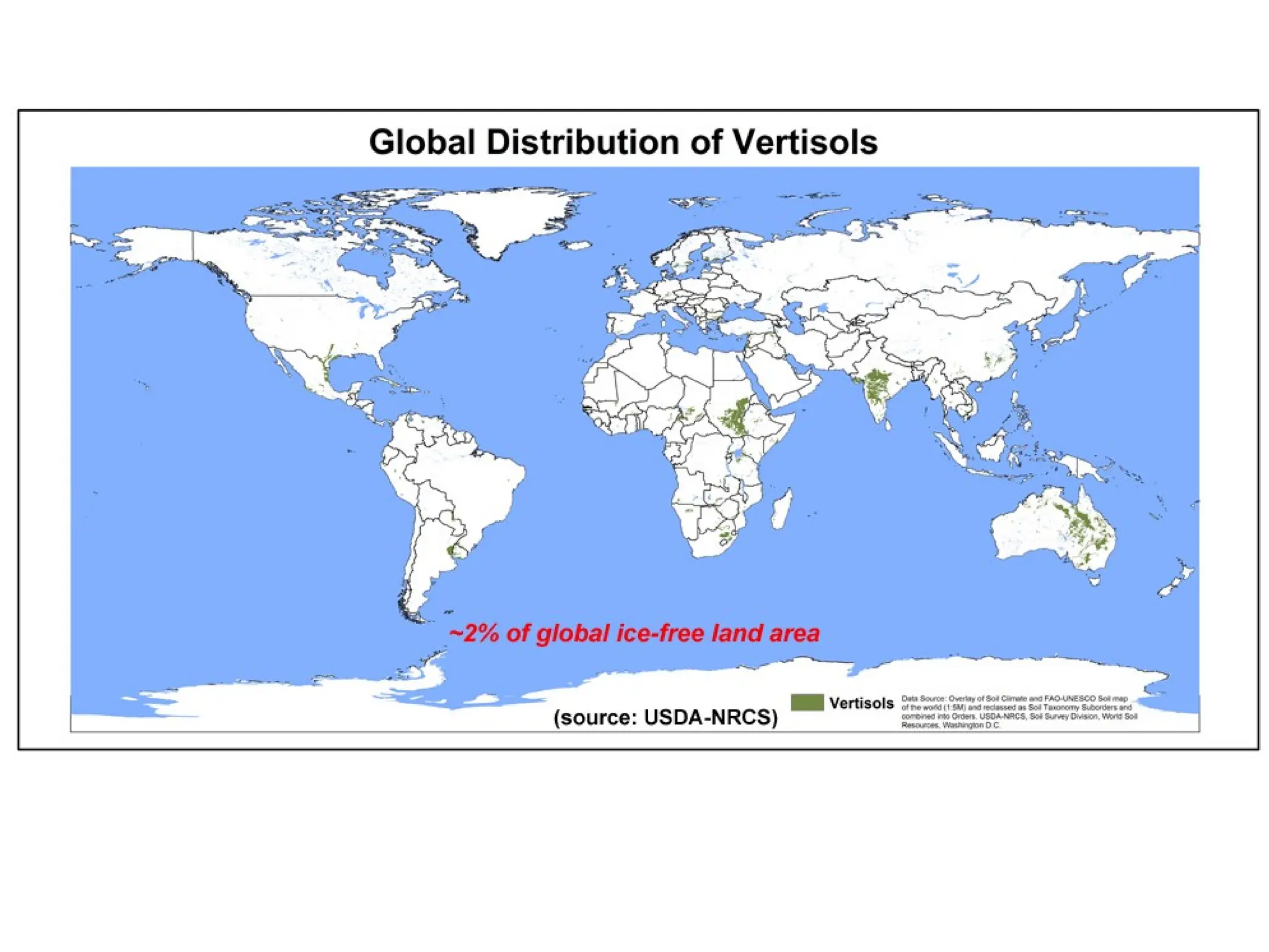
Vertisols
Vertisols areclay-rich soils that shrink and
swell with changes in moisture content. During
dry periods, the soil volume shrinks, and deep
wide cracks form. The soil volume then
expands as it wets up. This shrink/swell action
creates serious engineering problems and
generally prevents formation of distinct, well-
developed horizons in these soils.
Globally, Vertisols occupy ~2.4% of the ice-
free land area. Vertisols are divided into 6
suborders: Aquerts, Cryerts, Xererts, Torrerts,
Usterts, and Uderts.
35.
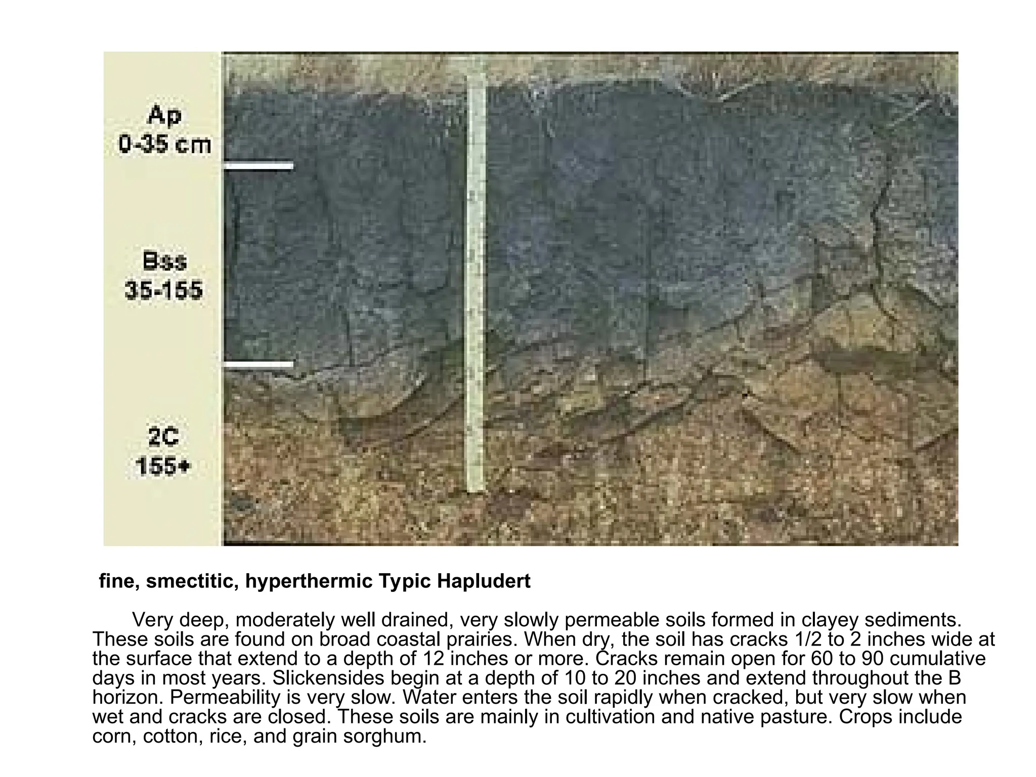
fine, smectitic, hyperthermicTypic Hapludert
Very deep, moderately well drained, very slowly permeable soils formed in clayey sediments.
These soils are found on broad coastal prairies. When dry, the soil has cracks 1/2 to 2 inches wide at
the surface that extend to a depth of 12 inches or more. Cracks remain open for 60 to 90 cumulative
days in most years. Slickensides begin at a depth of 10 to 20 inches and extend throughout the B
horizon. Permeability is very slow. Water enters the soil rapidly when cracked, but very slow when
wet and cracks are closed. These soils are mainly in cultivation and native pasture. Crops include
corn, cotton, rice, and grain sorghum.
37.
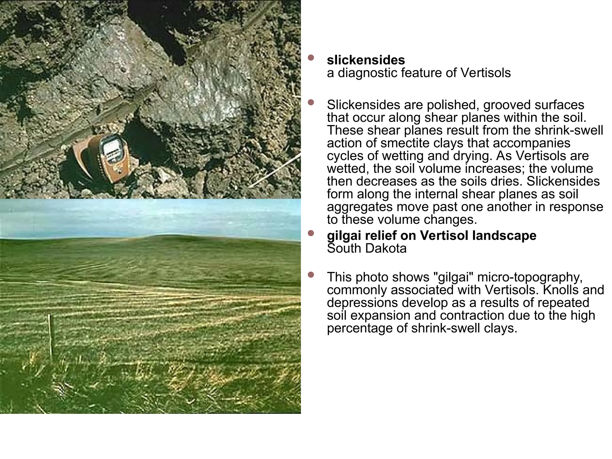
slickensides
a diagnosticfeature of Vertisols
Slickensides are polished, grooved surfaces
that occur along shear planes within the soil.
These shear planes result from the shrink-swell
action of smectite clays that accompanies
cycles of wetting and drying. As Vertisols are
wetted, the soil volume increases; the volume
then decreases as the soils dries. Slickensides
form along the internal shear planes as soil
aggregates move past one another in response
to these volume changes.
gilgai relief on Vertisol landscape
South Dakota
This photo shows "gilgai" micro-topography,
commonly associated with Vertisols. Knolls and
depressions develop as a results of repeated
soil expansion and contraction due to the high
percentage of shrink-swell clays.
38.
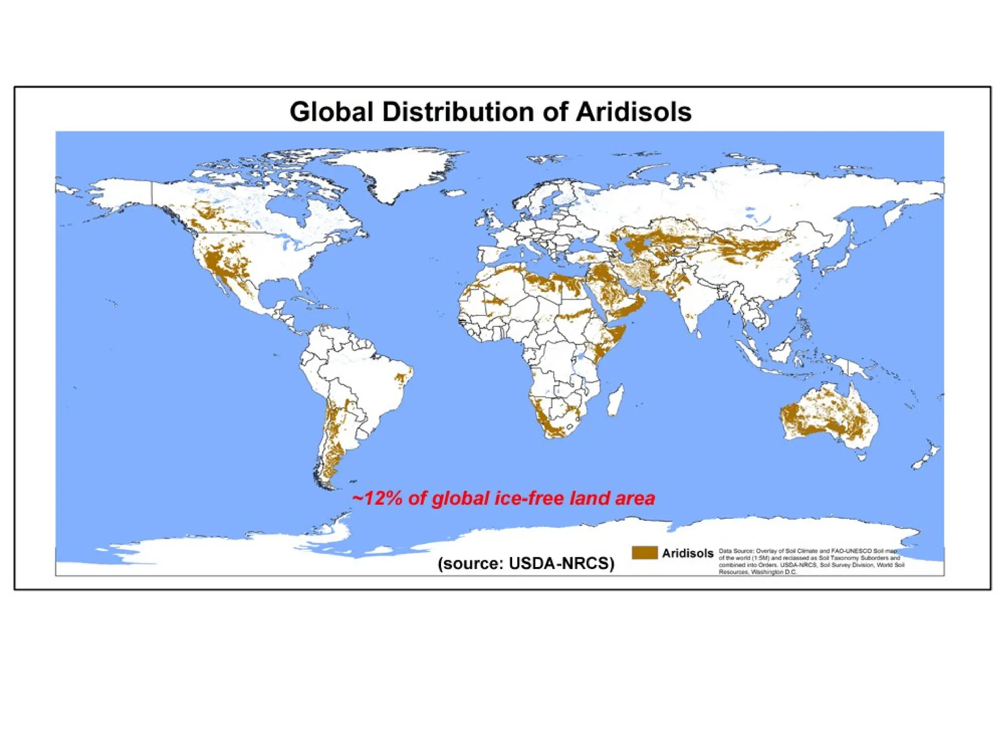
Aridisols
Aridisols areCaCO3-containing soils of arid regions that exhibit
at least some subsurface horizon development. They are
characterized by being dry most of the year and limited leaching.
Aridisols contain subsurface horizons in which clays, calcium
carbonate, silica, salts, and/or gypsum have accumulated.
Materials such as soluble salts, gypsum, and CaCO3 tend to be
leached from soils of moister climates.
Aridisols occupy ~12% of the Earth's ice-free land area
Aridisols are used mainly for range, wildlife, and recreation.
Because of the dry climate in which they are found, they are not
used for agricultural production unless irrigation water is
available.
Aridisols are divided into 7 suborders: Cryids, Salids, Durids,
Gypsids, Argids, Calcids, and Cambids.
39.
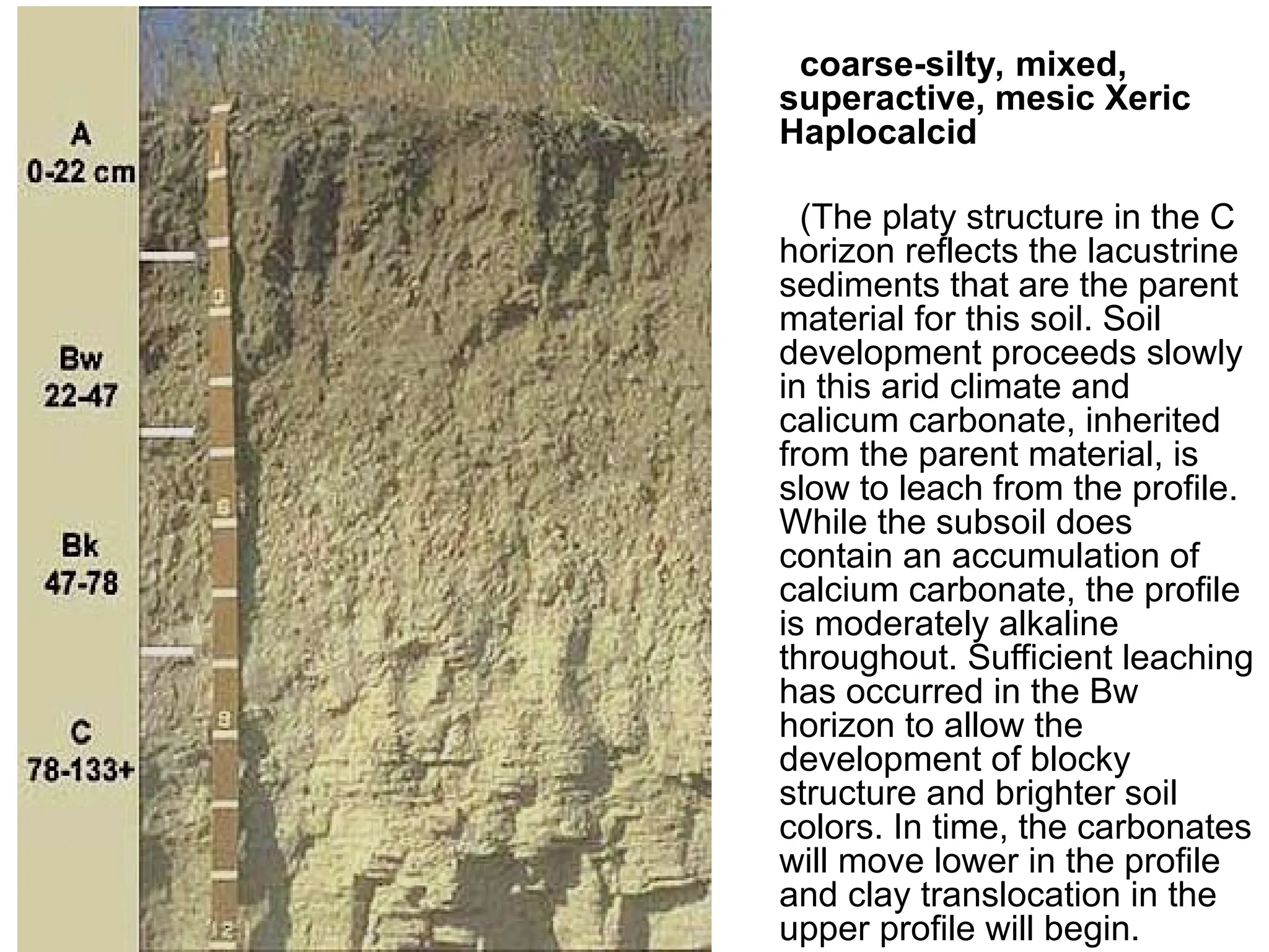
coarse-silty, mixed,
superactive, mesicXeric
Haplocalcid
(The platy structure in the C
horizon reflects the lacustrine
sediments that are the parent
material for this soil. Soil
development proceeds slowly
in this arid climate and
calicum carbonate, inherited
from the parent material, is
slow to leach from the profile.
While the subsoil does
contain an accumulation of
calcium carbonate, the profile
is moderately alkaline
throughout. Sufficient leaching
has occurred in the Bw
horizon to allow the
development of blocky
structure and brighter soil
colors. In time, the carbonates
will move lower in the profile
and clay translocation in the
upper profile will begin.
41.
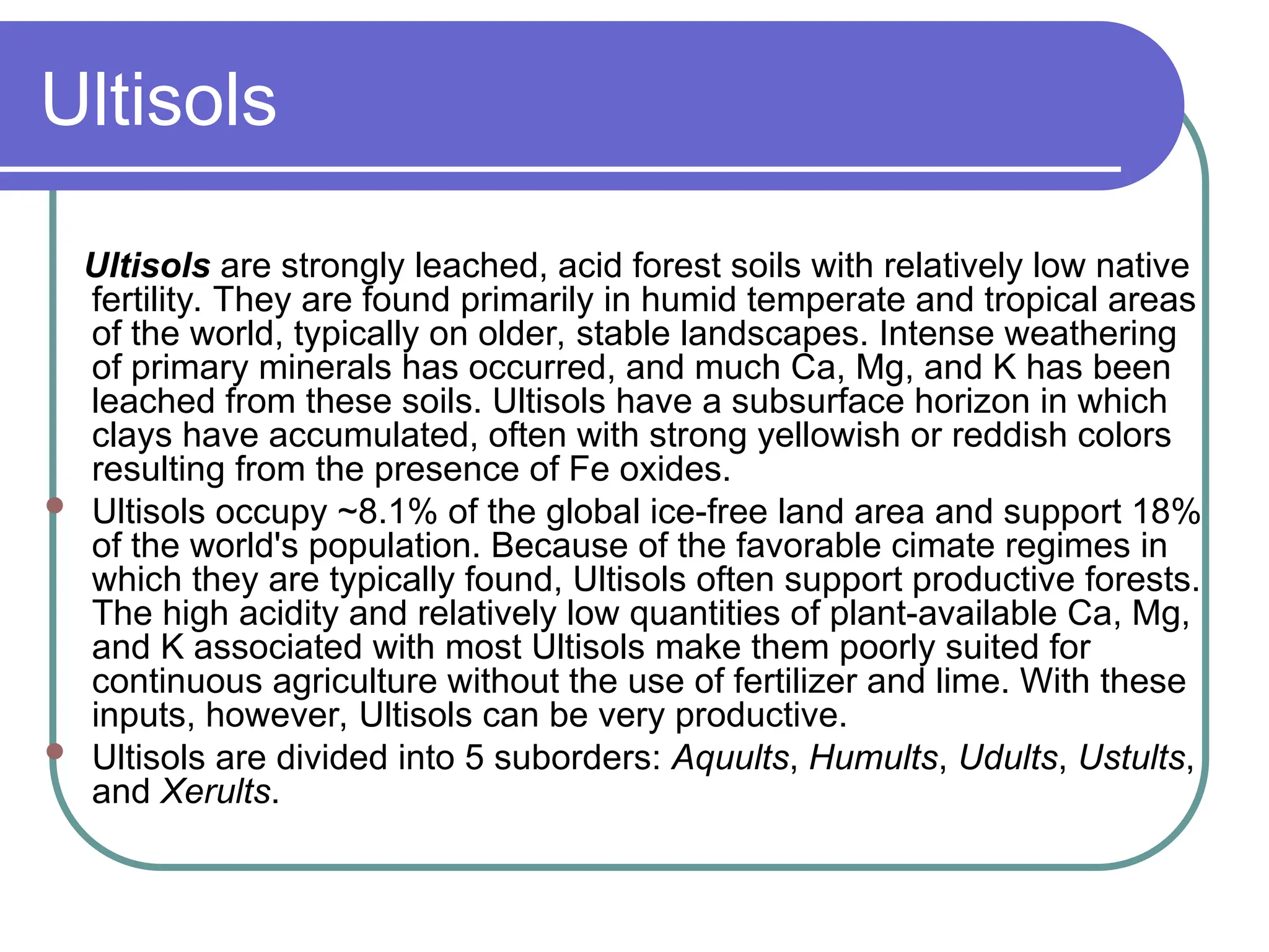
Ultisols
Ultisols are stronglyleached, acid forest soils with relatively low native
fertility. They are found primarily in humid temperate and tropical areas
of the world, typically on older, stable landscapes. Intense weathering
of primary minerals has occurred, and much Ca, Mg, and K has been
leached from these soils. Ultisols have a subsurface horizon in which
clays have accumulated, often with strong yellowish or reddish colors
resulting from the presence of Fe oxides.
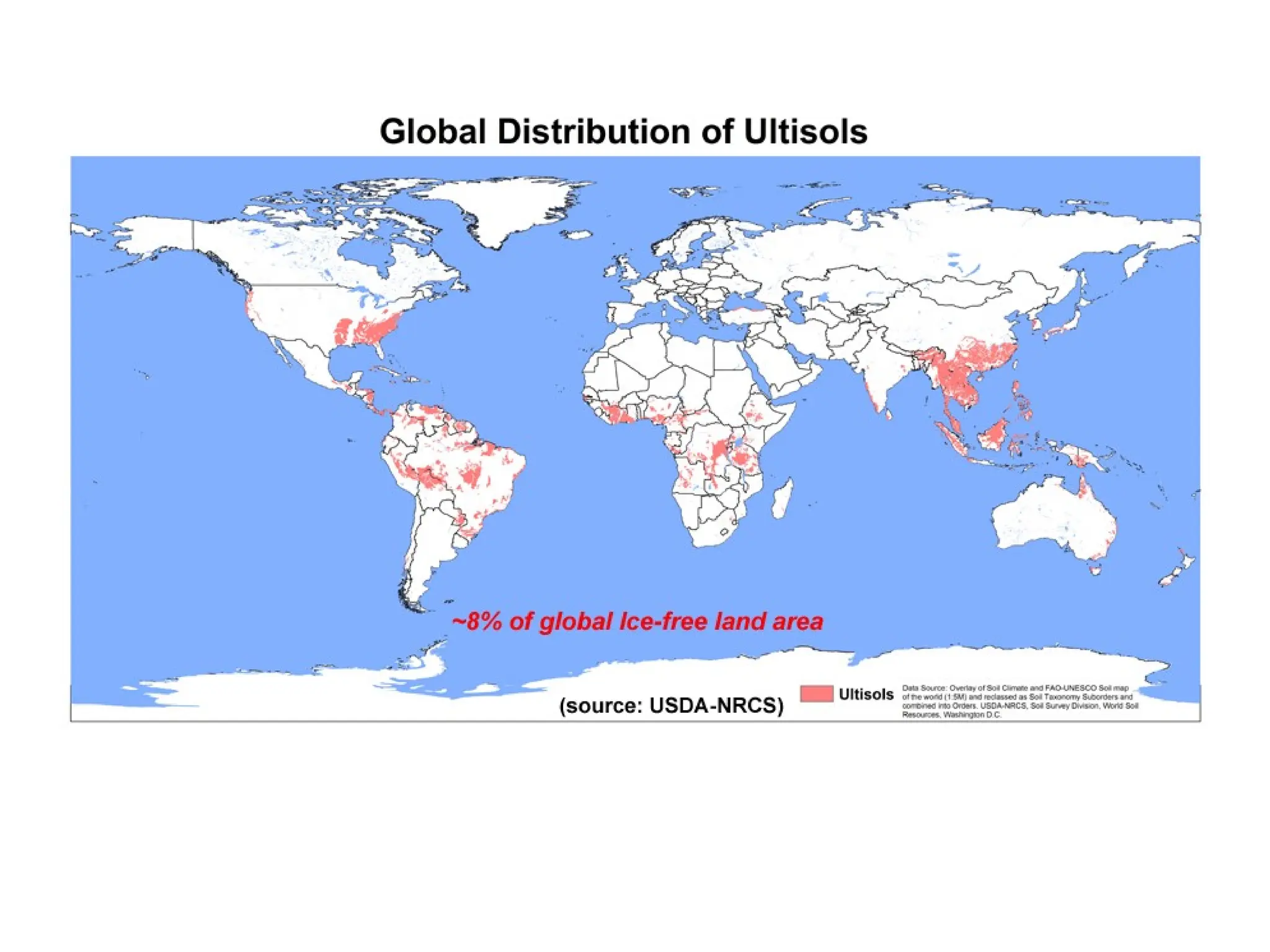
Ultisols occupy ~8.1% of the global ice-free land area and support 18%
of the world's population. Because of the favorable cimate regimes in
which they are typically found, Ultisols often support productive forests.
The high acidity and relatively low quantities of plant-available Ca, Mg,
and K associated with most Ultisols make them poorly suited for
continuous agriculture without the use of fertilizer and lime. With these
inputs, however, Ultisols can be very productive.
Ultisols are divided into 5 suborders: Aquults, Humults, Udults, Ustults,
and Xerults.
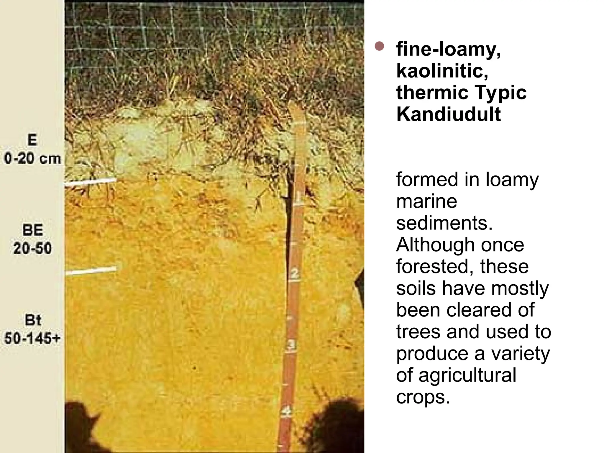
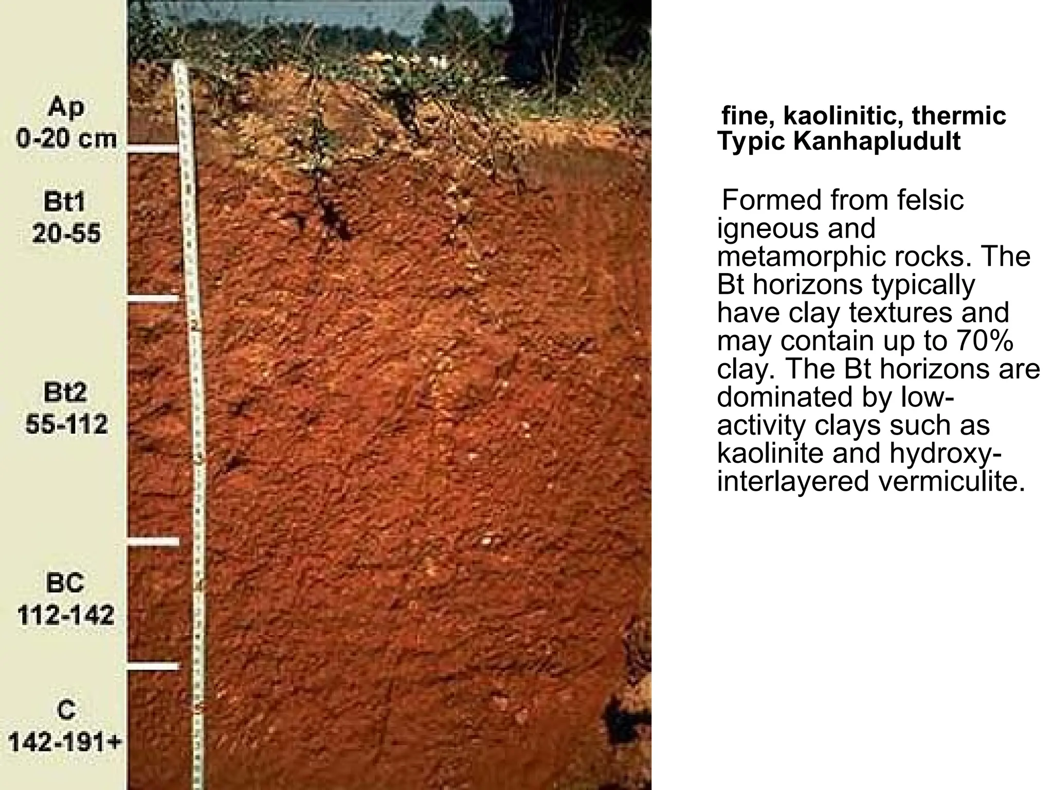
fine, kaolinitic, thermic
TypicKanhapludult
Formed from felsic
igneous and
metamorphic rocks. The
Bt horizons typically
have clay textures and
may contain up to 70%
clay. The Bt horizons are
dominated by low-
activity clays such as
kaolinite and hydroxy-
interlayered vermiculite.
45.
Mollisols
Mollisols arethe soils of grassland ecosystems. They are
characterized by a thick, dark surface horizon. This fertile surface
horizon, known as a mollic epipedon, results from the long-term
addition of organic materials derived from plant roots.
Mollisols primarily occur in the middle latitudes and are extensive
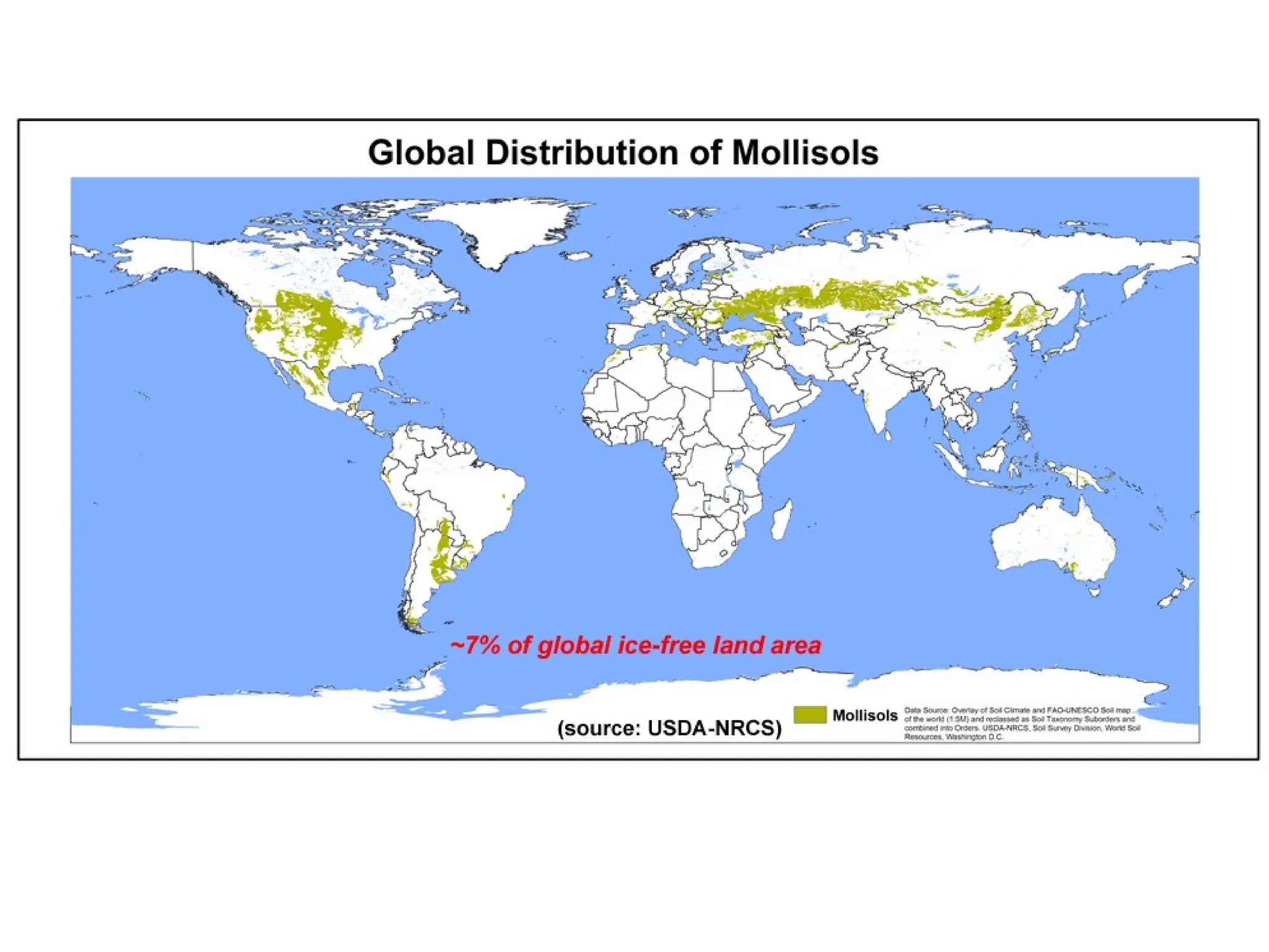
in prairie regions such as the Great Plains of the US. Globally,
they occupy ~7.0% of the ice-free land area.
Mollisols are among some of the most important and productive
agricultural soils in the world and are extensively used for this
purpose.
Mollisols are divided into 8 suborders: Albolls, Aquolls, Rendolls,
Gelolls, Cryolls, Xerolls, Ustolls, and Udolls.
46.
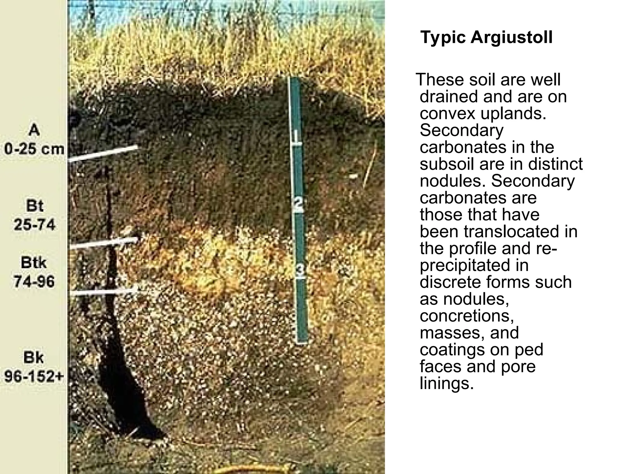
Typic Argiustoll
These soilare well
drained and are on
convex uplands.
Secondary
carbonates in the
subsoil are in distinct
nodules. Secondary
carbonates are
those that have
been translocated in
the profile and re-
precipitated in
discrete forms such
as nodules,
concretions,
masses, and
coatings on ped
faces and pore
linings.
48.
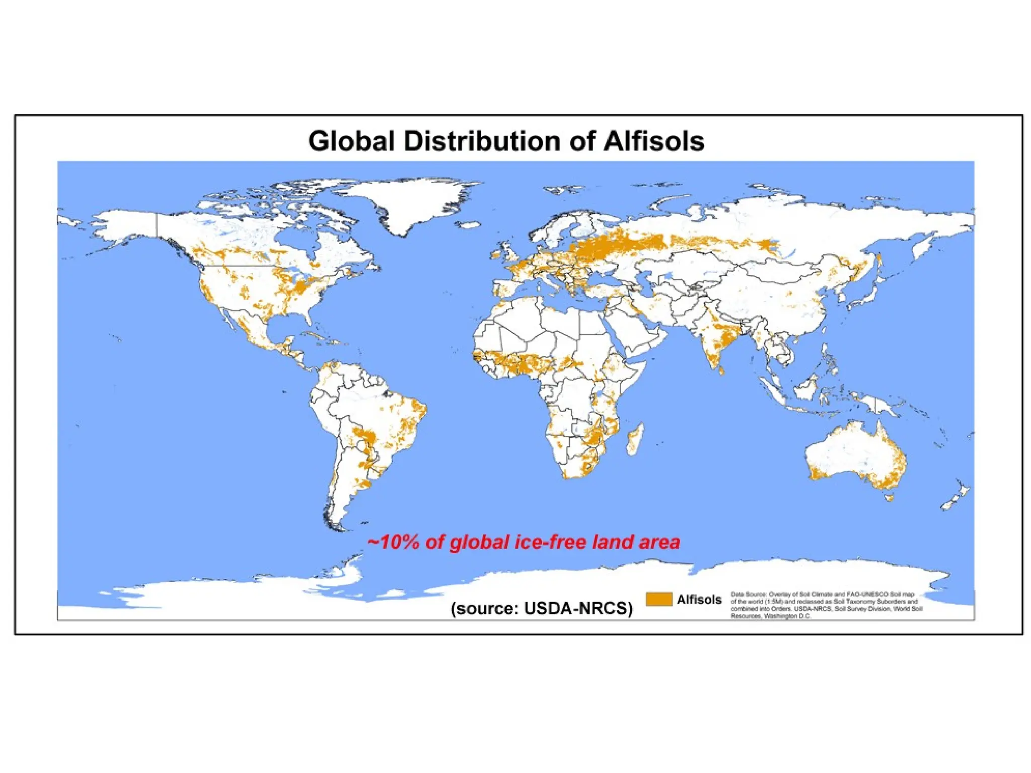
Alfisols
Alfisols aremoderately leached forest soils that have relatively
high native fertility. These soils are well developed and contain a
subsurface horizon in which clays have accumulated. Alfisols are
mostly found in temperate humid and subhumid regions of the
world.
Alfisols occupy ~10.1% of the global ice-free land area. Alfisols
support about 17% of the world's population.
The combination of generally favorable climate and high native
fertility allows Alfisols to be very productive soils for both
agricultural and silvicultural use.
Alfisols are divided into 5 suborders: Aqualfs, Cryalfs, Udalfs,
Ustalfs, and Xeralfs.
50.
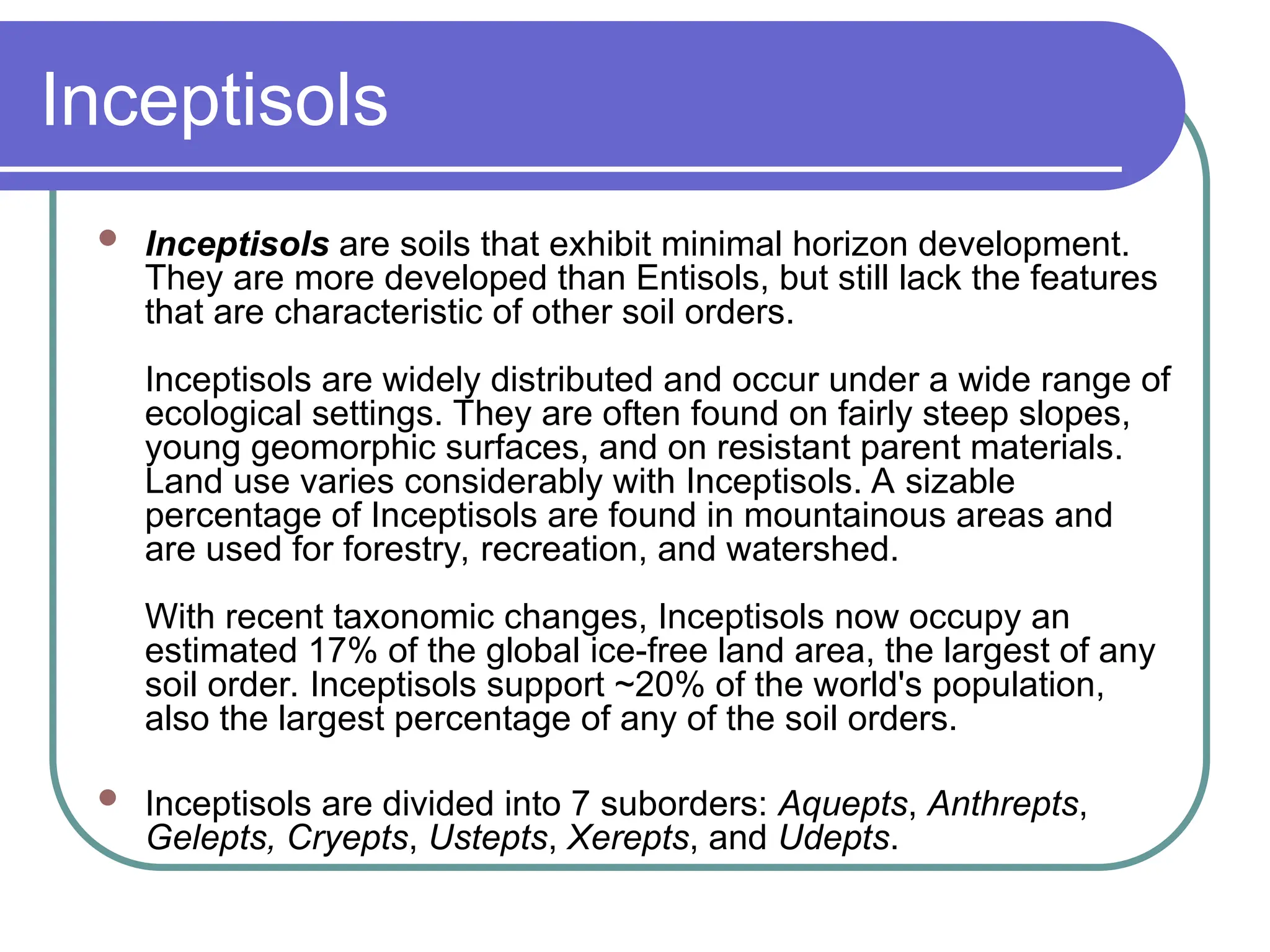
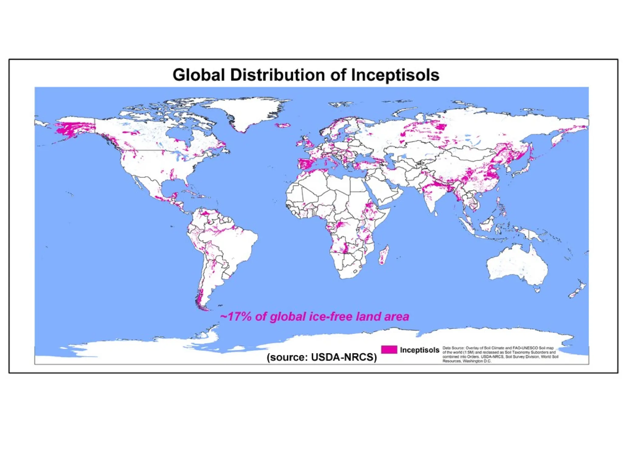
Inceptisols
Inceptisols aresoils that exhibit minimal horizon development.
They are more developed than Entisols, but still lack the features
that are characteristic of other soil orders.
Inceptisols are widely distributed and occur under a wide range of
ecological settings. They are often found on fairly steep slopes,
young geomorphic surfaces, and on resistant parent materials.
Land use varies considerably with Inceptisols. A sizable
percentage of Inceptisols are found in mountainous areas and
are used for forestry, recreation, and watershed.
With recent taxonomic changes, Inceptisols now occupy an
estimated 17% of the global ice-free land area, the largest of any
soil order. Inceptisols support ~20% of the world's population,
also the largest percentage of any of the soil orders.
Inceptisols are divided into 7 suborders: Aquepts, Anthrepts,
Gelepts, Cryepts, Ustepts, Xerepts, and Udepts.
51.
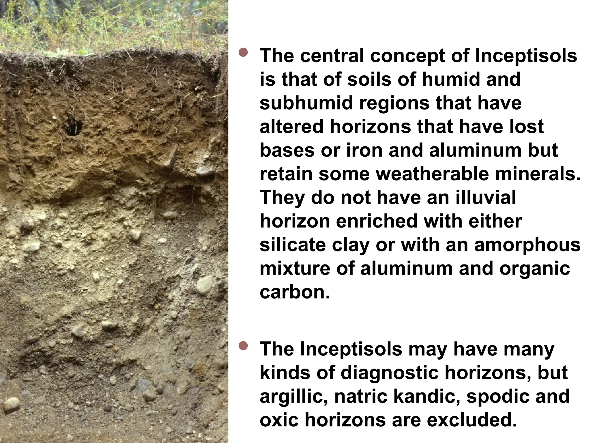
Inceptisols Thecentral concept of Inceptisols
is that of soils of humid and
subhumid regions that have
altered horizons that have lost
bases or iron and aluminum but
retain some weatherable minerals.
They do not have an illuvial
horizon enriched with either
silicate clay or with an amorphous
mixture of aluminum and organic
carbon.
The Inceptisols may have many
kinds of diagnostic horizons, but
argillic, natric kandic, spodic and
oxic horizons are excluded.
53.
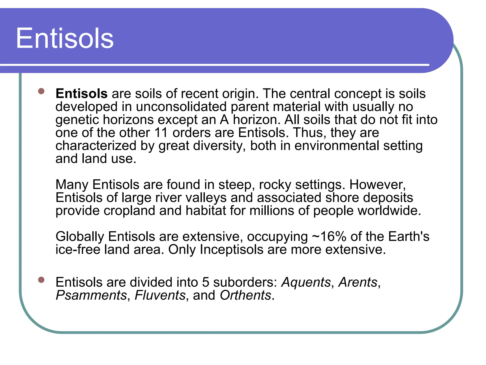
Entisols
Entisols aresoils of recent origin. The central concept is soils
developed in unconsolidated parent material with usually no
genetic horizons except an A horizon. All soils that do not fit into
one of the other 11 orders are Entisols. Thus, they are
characterized by great diversity, both in environmental setting
and land use.
Many Entisols are found in steep, rocky settings. However,
Entisols of large river valleys and associated shore deposits
provide cropland and habitat for millions of people worldwide.
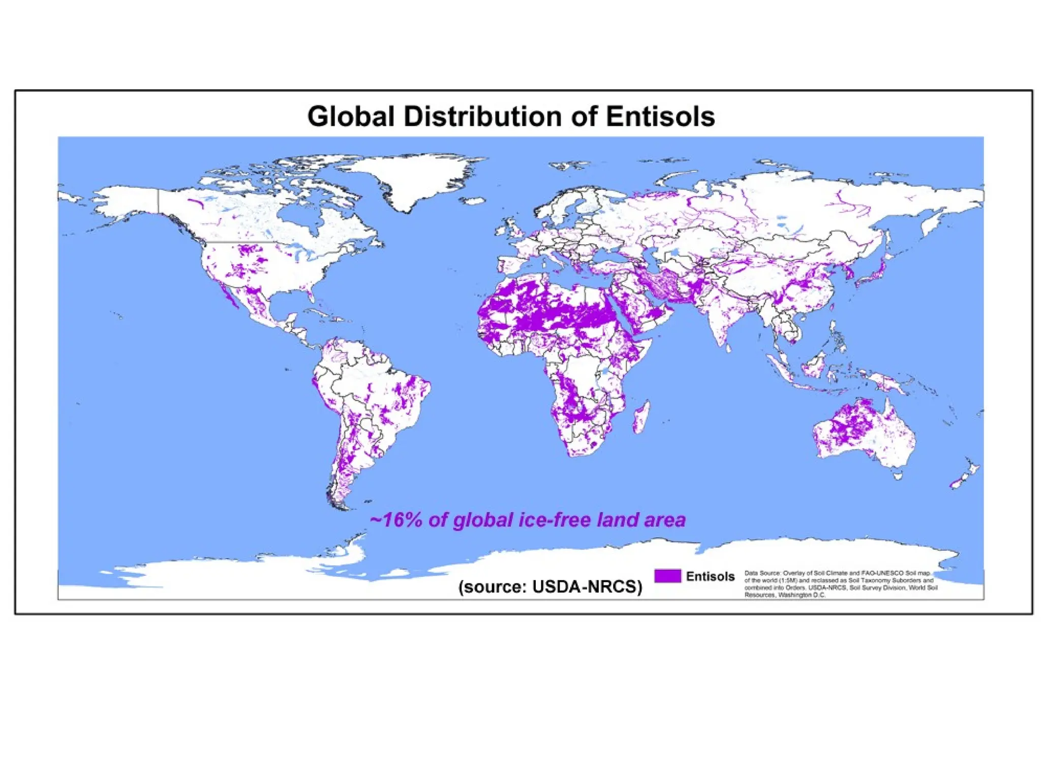
Globally Entisols are extensive, occupying ~16% of the Earth's
ice-free land area. Only Inceptisols are more extensive.
Entisols are divided into 5 suborders: Aquents, Arents,
Psamments, Fluvents, and Orthents.
54.
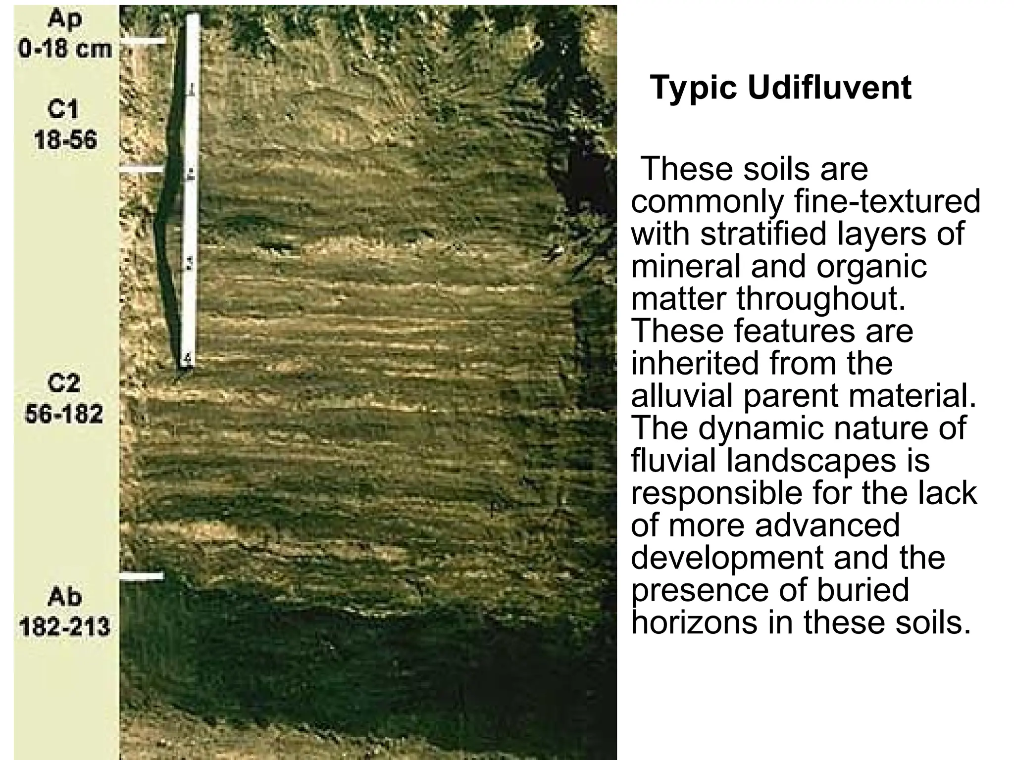
Typic Udifluvent
These soilsare
commonly fine-textured
with stratified layers of
mineral and organic
matter throughout.
These features are
inherited from the
alluvial parent material.
The dynamic nature of
fluvial landscapes is
responsible for the lack
of more advanced
development and the
presence of buried
horizons in these soils.

![Diagnostic horizon: subsurface
Kandic Horizon
Is a vertically continuous subsurface horizon that underlies a coarser textured surface horizon. The minimum thickness of the
surface horizon is 18 cm after mixing or 5 cm if the textural transition to the kandic horizon is abrupt and there is no densic, lithic,
paralithic, or petroferric contact (defined below) within 50 cm of the mineral soil surface; and
Has its upper boundary:
At the point where the clay percentage in the fine-earth fraction, increasing with depth within a vertical distance of 15 cm or
less, is either:
4 percent or more (absolute) higher than that in the surface horizon if that horizon has less than 20 percent total clay
in the fine-earth fraction; or
20 percent or more (relative) higher than that in the surface horizon if that horizon has 20 to 40 percent total clay in
the fine-earth fraction; or
8 percent or more (absolute) higher than that in the surface horizon if that horizon has more than 40 percent total clay
in the fine-earth fraction; and
At a depth:
Between 100 cm and 200 cm from the mineral soil surface if the particle-size class is sandy or sandy-skeletal
throughout the upper 100 cm; or
Within 100 cm from the mineral soil surface if the clay content in the fine-earth fraction of the surface horizon is 20
percent or more; or
Within 125 cm from the mineral soil surface for all other soils; and
Has a thickness of either:
30 cm or more; or
15 cm or more if there is a densic, lithic, paralithic, or petroferric contact within 50 cm of the mineral soil surface and the
kandic horizon constitutes 60 percent or more of the vertical distance between a depth of 18 cm and the contact; and
Has a texture of loamy very fine sand or finer; and
Has an apparent CEC of 16 cmol(+) or less per kg clay (by 1N NH4OAc pH 7) and an apparent ECEC of 12 cmol(+) or less per kg
clay (sum of bases extracted with 1N NH4OAc pH 7 plus 1N KCl-extractable Al) in 50 percent or more of its thickness between the
point where the clay increase requirements are met and either a depth of 100 cm below that point or a densic, lithic, paralithic, or
petroferric contact if shallower. (The percentage of clay is either measured by the pipette method or estimated to be 2.5 times
[percent water retained at 1500 kPa tension minus percent organic carbon], whichever is higher, but no more than 100); and
Has a regular decrease in organic-carbon content with increasing depth, no fine stratification, and no overlying layers more than 30
cm thick that have fine stratification and/or an organic-carbon content that decreases irregularly with increasing depth.](https://image.slidesharecdn.com/soilsoftheworld-250917030802-38c4d16a/75/Soils-of-the-worldforstudentinuniversity-ppt-21-2048.jpg)

![Hydrous, amorphic,
isothermic Acrudoxic
Hydrudand
In the upper 250 cm of this
soil, alternating A and B
horizons have formed as a
result of ash falls and
intermittent soil development
cycles. White specks in the C
horizon are gibbsite (Al[OH]3)
coatings. The 15-bar H2O
content ranges from 102-
211% in this soil. These soils
have very low cation
exchange capacity, <2.0
cmol(+)/kg.](https://image.slidesharecdn.com/soilsoftheworld-250917030802-38c4d16a/75/Soils-of-the-worldforstudentinuniversity-ppt-29-2048.jpg)


![Introduction STAG3203 - Course profile Igneous Rock [Compatibility Mode].pdf](https://cdn.slidesharecdn.com/ss_thumbnails/introductionstag3203-courseprofileigneousrockcompatibilitymode-250903074341-d4c258e3-thumbnail.jpg?width=640&height=640&fit=bounds)


