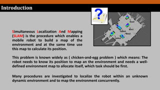
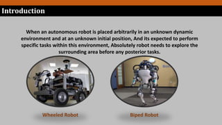
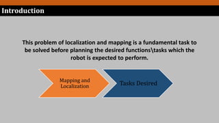
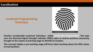
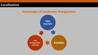
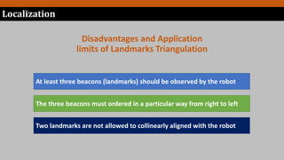
Simultaneous Localization And
Mapping (SLAM) for Indoor/Outdoor
Robots
Quick Overview
Contents
Introduction
Problem Statement
Mapping
Objectives and motivation
Localization
What is SLAM ?
Introduction and SLAM Problem Definition
Simultaneous Localization And Mapping
(SLAM) is the procedure which enables a
mobile robot to build a map of the
environment and at the same time use
this map to calculate its position.
This problem is known widely as ( chicken-and-egg problem ) which means: The
robot needs to know its position to map an the environment and needs a well-
defined environment map to allocate itself, which task should be first.
Many procedures are investigated to localize the robot within an unknown
dynamic environment and to map the environment concurrently.
Introduction
When an autonomous robot is placed arbitrarily in an unknown dynamic
environment and at an unknown initial position, And its expected to perform
specific tasks within this environment, Absolutely robot needs to explore the
surrounding area before any posterior tasks.
Wheeled Robot Biped Robot
Introduction
This problem of localization and mapping is a fundamental task to
be solved before planning the desired functionstasks which the
robot is expected to perform.
Mapping and
Localization Tasks Desired
Introduction
REVIEW
 Charles Cohen and Frank V. Koss in 1993 had introduced four methods to
determine position of the robot based on Three* detected landmarks which are
(Iterative search, Geometric circle intersection, Geometric triangulation, and Newton-
Raphson iterative method). They Discussed a detailed comparison between the four
algorithms. This comparison included the mean error in the position coordinate, the
mean error in orientation and number of fails of each technique.
* Some techniques used only two landmarks
 Shehata, H., and J. Schlattmann. Introduced a doctoral thesis to optimize the
path taken by a robot to reach its destination, This thesis incorporated a localization
technique based on only two landmarks, this technique mainly depend on
triangulations and circle intersections, which are employed to detect and define the
robot position as a prerior task before the path planning procedure introduced.
REVIEW
 Sebastian Thrun, et al . In 2006 had investigated some Probabilistic approaches
which became very popular in the late 90`s and where under extensive scientific
research by the pioneer of this field, Sebasitian Thrun. These probabilistic approaches
where the Kalman filtering (KF), Extended Kalman filtering (EKF), Unscented Kalman
filtering (UKF), Particle filtering (PF), etc.
A.Zhang, et al. in 2015 had introduced a method for landmarks based localization,
this approach uses the RSSI values received from the beacons to detect the position,
this technique known as landmarks fingerprinting which implies a teaching stage at
the off- line working.
Localization
Procedures and Techniques
Localization is describing the robots location inside the working area with respect
to some reference. The following are some procedures employed to localize a
robot indoors.
Localization
Dead-Reckoning
Landmark-Based Techniques
Probabilistic Localization Technique
Hybrid Techniques.
Localization
The landmarks technique employs the known positions of natural or artificial marks
present in the environment to refer the robot to.
Landmarks Technique
Uses robot sensors to detect known positioned landmarks (some times called beacons)
in the environment and further more robots location is investigated upon the distances
obtained from these land marks .
Localization
Landmark Triangulation
Technique
This image only to illustrate the uniqueness idea.
Localization
Landmark Fingerprinting
Technique
Another considerable Landmark Technique called Landmarks Fingerprinting, This type
uses the Received Signal Strength Indicator (RSSI) value at several positions previously
thought to the system at learning stage to identify its location.
This concept implies a pre-working stage (off-line) robot teaching about the RSSI values
of each position.
Localization
Advantages of Landmarks Triangulation
High
Accurate
Reliable
Low
Computatio-
nal Cost
Localization
Disadvantages and Application
limits of Landmarks Triangulation
At least three beacons (landmarks) should be observed by the robot
The three beacons must ordered in a particular way from right to left
Two landmarks are not allowed to collinearly aligned with the robot
For these reasons another methods should be involved in
addition to the landmarks triangulation technique in a
new hybrid technique to overcome the weaknesses of this
approach.
Localization
Hybrid
Technique
In this research we will try to develop a robust, high performance, and low
complexity SLAM method based on algorithms of three object triangulation,
artificial intelligence and Kalman filter technique.
Mapping
Procedures or Techniques
Is the process of creating a map of the environment through searching and
exploring , The challenge here is to continuously capture an imagination
about the environment as in practical the environment changes with
respect to time (dynamic environment).
When the problem of mapping is considered, we assume that robots
location is well known so that any associated date from the environment
can be relatively described to some reference coordinate.
Mapping
Mapping
Mapping
Topological
Methods
Metric Methods
Mapping Methods Categories
In this method RGB-D cameras are used to map the environment, as they have the ability
to measure the depth of any desired object in the surrounding environment. Some types
are shown here:
Topological Mapping
Mapping
Metric Mapping
Mapping
In this type of mapping range finders such as LASER ones are used to assign the
coordinates of all objects, features, obstacles and even the landmarks their self with
respect to a global co-ordination frame. The following is an example for LASER sensors.
SLAM

SLAM

  • 1.
    Simultaneous Localization And Mapping(SLAM) for Indoor/Outdoor Robots Quick Overview
  • 2.
  • 3.
    What is SLAM? Introduction and SLAM Problem Definition
  • 4.
    Simultaneous Localization AndMapping (SLAM) is the procedure which enables a mobile robot to build a map of the environment and at the same time use this map to calculate its position. This problem is known widely as ( chicken-and-egg problem ) which means: The robot needs to know its position to map an the environment and needs a well- defined environment map to allocate itself, which task should be first. Many procedures are investigated to localize the robot within an unknown dynamic environment and to map the environment concurrently. Introduction
  • 5.
    When an autonomousrobot is placed arbitrarily in an unknown dynamic environment and at an unknown initial position, And its expected to perform specific tasks within this environment, Absolutely robot needs to explore the surrounding area before any posterior tasks. Wheeled Robot Biped Robot Introduction
  • 6.
    This problem oflocalization and mapping is a fundamental task to be solved before planning the desired functionstasks which the robot is expected to perform. Mapping and Localization Tasks Desired Introduction
  • 7.
    REVIEW  Charles Cohenand Frank V. Koss in 1993 had introduced four methods to determine position of the robot based on Three* detected landmarks which are (Iterative search, Geometric circle intersection, Geometric triangulation, and Newton- Raphson iterative method). They Discussed a detailed comparison between the four algorithms. This comparison included the mean error in the position coordinate, the mean error in orientation and number of fails of each technique. * Some techniques used only two landmarks  Shehata, H., and J. Schlattmann. Introduced a doctoral thesis to optimize the path taken by a robot to reach its destination, This thesis incorporated a localization technique based on only two landmarks, this technique mainly depend on triangulations and circle intersections, which are employed to detect and define the robot position as a prerior task before the path planning procedure introduced.
  • 8.
    REVIEW  Sebastian Thrun,et al . In 2006 had investigated some Probabilistic approaches which became very popular in the late 90`s and where under extensive scientific research by the pioneer of this field, Sebasitian Thrun. These probabilistic approaches where the Kalman filtering (KF), Extended Kalman filtering (EKF), Unscented Kalman filtering (UKF), Particle filtering (PF), etc. A.Zhang, et al. in 2015 had introduced a method for landmarks based localization, this approach uses the RSSI values received from the beacons to detect the position, this technique known as landmarks fingerprinting which implies a teaching stage at the off- line working.
  • 9.
  • 10.
    Localization is describingthe robots location inside the working area with respect to some reference. The following are some procedures employed to localize a robot indoors. Localization Dead-Reckoning Landmark-Based Techniques Probabilistic Localization Technique Hybrid Techniques.
  • 11.
    Localization The landmarks techniqueemploys the known positions of natural or artificial marks present in the environment to refer the robot to. Landmarks Technique
  • 12.
    Uses robot sensorsto detect known positioned landmarks (some times called beacons) in the environment and further more robots location is investigated upon the distances obtained from these land marks . Localization Landmark Triangulation Technique
  • 13.
    This image onlyto illustrate the uniqueness idea. Localization Landmark Fingerprinting Technique Another considerable Landmark Technique called Landmarks Fingerprinting, This type uses the Received Signal Strength Indicator (RSSI) value at several positions previously thought to the system at learning stage to identify its location. This concept implies a pre-working stage (off-line) robot teaching about the RSSI values of each position.
  • 14.
    Localization Advantages of LandmarksTriangulation High Accurate Reliable Low Computatio- nal Cost
  • 15.
    Localization Disadvantages and Application limitsof Landmarks Triangulation At least three beacons (landmarks) should be observed by the robot The three beacons must ordered in a particular way from right to left Two landmarks are not allowed to collinearly aligned with the robot
  • 16.
    For these reasonsanother methods should be involved in addition to the landmarks triangulation technique in a new hybrid technique to overcome the weaknesses of this approach. Localization Hybrid Technique In this research we will try to develop a robust, high performance, and low complexity SLAM method based on algorithms of three object triangulation, artificial intelligence and Kalman filter technique.
  • 17.
  • 18.
    Is the processof creating a map of the environment through searching and exploring , The challenge here is to continuously capture an imagination about the environment as in practical the environment changes with respect to time (dynamic environment). When the problem of mapping is considered, we assume that robots location is well known so that any associated date from the environment can be relatively described to some reference coordinate. Mapping
  • 19.
  • 20.
    In this methodRGB-D cameras are used to map the environment, as they have the ability to measure the depth of any desired object in the surrounding environment. Some types are shown here: Topological Mapping Mapping
  • 21.
    Metric Mapping Mapping In thistype of mapping range finders such as LASER ones are used to assign the coordinates of all objects, features, obstacles and even the landmarks their self with respect to a global co-ordination frame. The following is an example for LASER sensors.