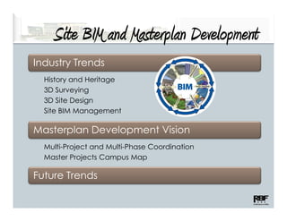
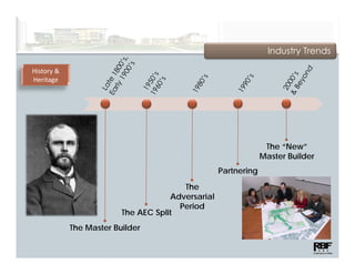
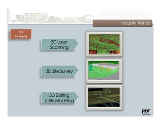
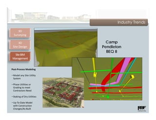
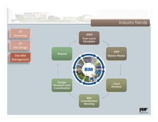
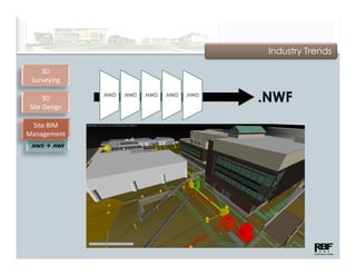
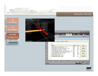
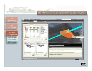
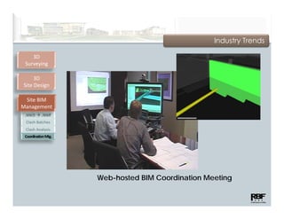
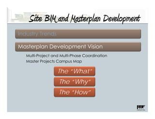
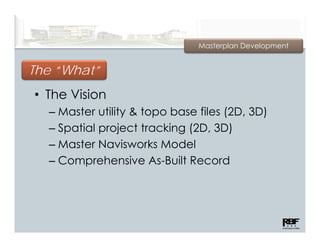
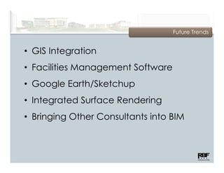
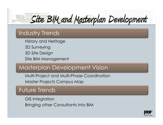
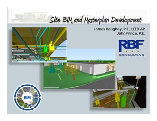
Site BIM and Masterplan Development
                      p          p
                    Building Information Modeling for the Site

                                         James Haughey, P.E., LEED AP
                                                    John Prince, P.E.


Truncated PDF Version – 01/11
3/2/2011
Site BIM and Masterplan Development
    S M Ms p                      p
Industry Trends
  History and Heritage
  3D Surveying
  3D Site Design
  Site BIM Management

Masterplan Development Vision
  Multi-Project and Multi-Phase Coordination
  Master Projects Campus Map

Future Trends
Industry Trends

History & 
Heritage


                                                                  The “New”
                                                                 Master B ild
                                                                 M t Builder
                                                    Partnering

                                         The
                                      Adversarial
                                        Period
                          The AEC Split
             The Master Builder
Industry Trends

   3D
Surveying
               3D Laser
              Scanning


            3D Site Survey
               Sit S


               3D Existing
            Utility Modeling
Industry Trends

   3D        •   Capture high-resolution    •   Usable in
Surveying
                 existing conditions data       conventional CADD
 3D Laser                                       environments and
 Scanning
             •   Ideal for Areas of             BIM modeling
                 Complex Constraints
                 –   Rooftops
                                            •   Accuracies within
                                                A        i    ithi
                 –   Interior Renovations       5 millimeters
                 –   Building Expansions
                 –   Facility Upgrades
Industry Trends

     3D
  Surveying
     3D Laser 
     Scanning

         3D
    Site Survey
              y


• Traditional Surveying 
  with 3D Processing

• Site Features 
  Generated 
  Automatically

• Accurate Surface
  Accurate Surface 
  Model Ready for BIM

• Detailed Site Culture 
  to Meet Needs
3D
Surveying
      3D
                 AutoCAD               Navisworks
Laser Scanning

      3D
 Site Survey
           y


                      One File - Multiple Softwares/Uses
Industry Trends

   3D
Surveying
   3D Laser 
   Scanning

       3D
  Site Survey
            y

  3D Existing
Utility Modeling


−Various
 Various 
 Reference 
 Sources

−Ready for BIM

−Embedded 
 System 
 Information
Industry Trends

      3D
   Surveying

       3D
  Site Design

• Site Utility and 
  Surface Design

 −Visual Design

 −Dynamic 3D 
  Environment

 −Increased 
  Quality

 −Fewer Field 
  Revisions
Industry Trends

     3D
  Surveying

       3D
  Site Design

 Site BIM 
Management

• Building BIM vs. 
  Building BIM vs
  Site BIM
• Engineer 
  Responsible for 
  Site Control
  Site Control
• Clash Detection
• Team Coordination
Industry Trends

     3D
  Surveying

      3D                      Camp
 Site Design                Pendleton
                              BEQ 8
  Site BIM 
 Management


Post‐Process Modeling

−Model any Site Utility 
 System

−Phase Utilities or 
 Grading to meet 
 Contractors Need

−Staking of Dry Utilities
       g      y

−Up‐To‐Date Model 
 with Construction 
 Changes/As‐Built
Industry Trends

    3D
 Surveying                       .NWD
                               from each
                               f         h
                                Discipline
     3D
Site Design
                                                .NWF
                 Repeat
 Site BIM                                    Master Model
Management


                 Design
                                                Clash
              Revisions and
                                               Analysis
              Coordination


                                  BIM
                              Coordination
                                Meeting
Industry Trends

    3D
 Surveying

                .NWD   .NWD   .NWD   .NWD   .NWD
     3D
Site Design

 Site BIM 
Management
 .NWD    .NWF
Industry Trends

    3D
 Surveying

     3D
Site Design

 Site BIM 
Management
 .NWD    .NWF
 Clash Batches
 Clash Batches
Site Information Modeling for Optimized Construction

    3D
 Surveying

     3D
Site Design

 Site BIM 
Management
 .NWD    .NWF
 Clash Batches
 Clash Batches
 Clash Analysis
Industry Trends

    3D
 Surveying

     3D
Site Design

 Site BIM 
Management
 .NWD      .NWF
 Clash Batches
 Clash Batches
 Clash Analysis
 Coordination Mtg.


                     Web-hosted BIM Coordination Meeting
Site BIM and Masterplan Development
    S M Ms p                      p
Industry Trends

Masterplan Development Vision
   Multi-Project and Multi-Phase Coordination
   Master Projects Campus Map

                   The “What”
                         Why
                    The “Why”
                   The “How”
Masterplan Development


The “What”
• The Vision
  – Master utility & topo base files (2D, 3D)
    M t      tilit   t    b    fil (2D
  – Spatial project tracking (2D, 3D)
  – Master Navisworks Model
  – Comprehensive As-Built Record
Masterplan Development


       y
The “Why”
• The Benefits
  – Centrall File and Knowledge Resource
    C t Fil         dK      l d    R
  – Consistency in Files and Project
    Information
    I f     ti
  – Comprehensive As-Built CAD Files and
    Model
  – Visualization of Multiple Projects
Masterplan Development
Rendered buildings by NTD Architecture and GKK Works
Underground Electrical by Gould Electric
Underground Wet Utilities and Surface Rendering by RBF Consulting


      Master Campus Navisworks Model
Masterplan Development

 5. Heavy Duty                                 9.
  AT&T/Diesel                               Aviation
  Technology                                Building


The “How”
 h “    ”
Reference
Drawings Binder
Coordination &                      6.
Tracking Plan                    Student
                                  Union
Master Projects
Campus Map
Affected Projects
     y
Easily Identifiable

    Master Projects Campus Map
Masterplan Development
CAD & NAVIS Files
                               Design
                             Line Work           XREF
                             Project C
    Design                             Design
  Line Work                          Line Work
  Project B                          Project A
Future Trends


• GIS Integration
• Facilities Management Software
• Google Earth/Sketchup
• I t
  Integrated Surface Rendering
         t dS f      R d i
• Bringing Other Consultants into BIM
Site BIM and Masterplan Development
     S M Ms p                      p
Industry Trends
  History and Heritage
  3D Surveying
  3D Site Design
              g
  Site BIM Management

Masterplan Development Vision
      p          p
  Multi-Project and Multi-Phase Coordination
  Master Projects Campus Map

Future Trends
  GIS Integration
  Bringing other Consultants into BIM
Site BIM and Masterplan Development
      IM
                James Haughey, P.E., LEED AP
                           John Prince, P.E.

Site BIM at RBF

  • 1.
    Site BIM andMasterplan Development p p Building Information Modeling for the Site James Haughey, P.E., LEED AP John Prince, P.E. Truncated PDF Version – 01/11 3/2/2011
  • 2.
    Site BIM andMasterplan Development S M Ms p p Industry Trends History and Heritage 3D Surveying 3D Site Design Site BIM Management Masterplan Development Vision Multi-Project and Multi-Phase Coordination Master Projects Campus Map Future Trends
  • 3.
    Industry Trends History &  Heritage The “New” Master B ild M t Builder Partnering The Adversarial Period The AEC Split The Master Builder
  • 4.
    Industry Trends 3D Surveying 3D Laser Scanning 3D Site Survey Sit S 3D Existing Utility Modeling
  • 5.
    Industry Trends 3D • Capture high-resolution • Usable in Surveying existing conditions data conventional CADD 3D Laser  environments and Scanning • Ideal for Areas of BIM modeling Complex Constraints – Rooftops • Accuracies within A i ithi – Interior Renovations 5 millimeters – Building Expansions – Facility Upgrades
  • 6.
    Industry Trends 3D Surveying 3D Laser  Scanning 3D Site Survey y • Traditional Surveying  with 3D Processing • Site Features  Generated  Automatically • Accurate Surface Accurate Surface  Model Ready for BIM • Detailed Site Culture  to Meet Needs
  • 7.
    Industry Trends 3D Surveying 3D Laser  Scanning 3D Site Survey y • Traditional Surveying  with 3D Processing • Site Features  Generated  Automatically • Accurate Surface Accurate Surface  Model Ready for BIM • Detailed Site Culture  to Meet Needs
  • 8.
    3D Surveying 3D AutoCAD Navisworks Laser Scanning 3D Site Survey y One File - Multiple Softwares/Uses
  • 9.
    Industry Trends 3D Surveying 3D Laser  Scanning 3D Site Survey y 3D Existing Utility Modeling −Various Various  Reference  Sources −Ready for BIM −Embedded  System  Information
  • 10.
    Industry Trends 3D Surveying 3D Site Design • Site Utility and  Surface Design −Visual Design −Dynamic 3D  Environment −Increased  Quality −Fewer Field  Revisions
  • 11.
    Industry Trends 3D Surveying 3D Site Design Site BIM  Management • Building BIM vs.  Building BIM vs Site BIM • Engineer  Responsible for  Site Control Site Control • Clash Detection • Team Coordination
  • 12.
    Industry Trends 3D Surveying 3D Camp Site Design Pendleton BEQ 8 Site BIM  Management Post‐Process Modeling −Model any Site Utility  System −Phase Utilities or  Grading to meet  Contractors Need −Staking of Dry Utilities g y −Up‐To‐Date Model  with Construction  Changes/As‐Built
  • 13.
    Industry Trends 3D Surveying .NWD from each f h Discipline 3D Site Design .NWF Repeat Site BIM  Master Model Management Design Clash Revisions and Analysis Coordination BIM Coordination Meeting
  • 14.
    Industry Trends 3D Surveying .NWD .NWD .NWD .NWD .NWD 3D Site Design Site BIM  Management .NWD  .NWF
  • 15.
    Industry Trends 3D Surveying 3D Site Design Site BIM  Management .NWD  .NWF Clash Batches Clash Batches
  • 16.
    Site Information Modelingfor Optimized Construction 3D Surveying 3D Site Design Site BIM  Management .NWD  .NWF Clash Batches Clash Batches Clash Analysis
  • 17.
    Industry Trends 3D Surveying 3D Site Design Site BIM  Management .NWD  .NWF Clash Batches Clash Batches Clash Analysis Coordination Mtg. Web-hosted BIM Coordination Meeting
  • 18.
    Site BIM andMasterplan Development S M Ms p p Industry Trends Masterplan Development Vision Multi-Project and Multi-Phase Coordination Master Projects Campus Map The “What” Why The “Why” The “How”
  • 19.
    Masterplan Development The “What” •The Vision – Master utility & topo base files (2D, 3D) M t tilit t b fil (2D – Spatial project tracking (2D, 3D) – Master Navisworks Model – Comprehensive As-Built Record
  • 20.
    Masterplan Development y The “Why” • The Benefits – Centrall File and Knowledge Resource C t Fil dK l d R – Consistency in Files and Project Information I f ti – Comprehensive As-Built CAD Files and Model – Visualization of Multiple Projects
  • 21.
    Masterplan Development Rendered buildingsby NTD Architecture and GKK Works Underground Electrical by Gould Electric Underground Wet Utilities and Surface Rendering by RBF Consulting Master Campus Navisworks Model
  • 22.
    Masterplan Development 5.Heavy Duty 9. AT&T/Diesel Aviation Technology Building The “How” h “ ” Reference Drawings Binder Coordination & 6. Tracking Plan Student Union Master Projects Campus Map Affected Projects y Easily Identifiable Master Projects Campus Map
  • 23.
    Masterplan Development CAD &NAVIS Files Design Line Work XREF Project C Design Design Line Work Line Work Project B Project A
  • 24.
    Future Trends • GISIntegration • Facilities Management Software • Google Earth/Sketchup • I t Integrated Surface Rendering t dS f R d i • Bringing Other Consultants into BIM
  • 25.
    Site BIM andMasterplan Development S M Ms p p Industry Trends History and Heritage 3D Surveying 3D Site Design g Site BIM Management Masterplan Development Vision p p Multi-Project and Multi-Phase Coordination Master Projects Campus Map Future Trends GIS Integration Bringing other Consultants into BIM
  • 26.
    Site BIM andMasterplan Development IM James Haughey, P.E., LEED AP John Prince, P.E.