1. 1 | P a g e
To what extend does the change in extreme climatic conditions since the twentieth century have an impact on the mishing tribe of Majuli Island, Assam, India?
Subject - Environmental Systems and Societies
Session – 2012 - 2014
Word Count – 3999
2. 2 | P a g e
Table of Contents
Abstract ................................................................................................................................................... 3
Introduction ............................................................................................................................................ 4
About the Island ...................................................................................................................................... 6
Overview ................................................................................................................................................. 8
Objective: ................................................................................................................................................ 9
The Mishing Tribe: ................................................................................................................................ 10
Weather conditions .............................................................................................................................. 12
PROBLEM OF EROSION ......................................................................................................................... 13
Practice being followed......................................................................................................................... 15
A study of the effect on the mishing tribe due to the erosional activities ........................................... 17
INTERVIEWS: ..................................................................................................................................... 17
DATA EXPERIMENT: .......................................................................................................................... 20
Effect on the lives .................................................................................................................................. 27
Conclusion for report ............................................................................................................................ 32
Bibliography .......................................................................................................................................... 34
Websites ........................................................................................................................................... 34
Research paper ................................................................................................................................. 35
Journals ............................................................................................................................................. 36
Blogs .................................................................................................................................................. 36
APPENDIX 1 ........................................................................................................................................... 38
3. 3 | P a g e
Abstract
This extended essay discusses the degree to which the mishing tribe of Majuli Island is affected by the change in extreme climatic conditions and the various measures which are under-taken to cope up with the problem in the Majuli Island. The research question that is being discussed here is “To what extend does the change in extreme climatic conditions since the twentieth century has an impact on the mishing tribe of Majuli Island, Assam, India?”
The study was conducted under a series of questions and experiments with the incorporation of primary data. Firstly the residents of Majuli Island were interviewed for that houses were selected at random to analyse their problems along with the various measures taken by them and government to protect the island. Experiments were conducted with the help of water and soil samples. The pH of soil and water was checked along with the conductivity of water. Results indicated that the erosional activities are degrading the quality of water as well as soil which is further affecting the lives of mishing tribe as well as aquatic animals. The part of island which is highly affected is the outer-part of the island.
The investigation was conducted with a time constraint of two days which controlled the amount of valuable data that could be collected. Time constraint allowed me to survey on random basis.
After the survey I came to a conclusion that the mishing tribe of the Majuli Island is badly affected by the change in extreme climatic conditions. The island is decreasing at a very fast pace and it is high time that government takes necessary measures to help the residents of the Majuli Island.
Word count: 278
4. 4 | P a g e
Introduction
Figure1 : SATELLITE VIEW OF MAJULI ISLAND
With the increasing harshness and frequency of the extreme climatic condition humans are being immeasurably affected. In this world of technology there are many places where indigenous people are using old techniques to cope up these problems. Disaster do not say that be prepared I am going to come but there are some societies which know the time of their arrival and thus prepare themselves to cope up with them. Though they are prepared for disasters, it just scatters every possible thing. So in these situations not the technology but the indigenous knowledge of the tribal people helps to rescue the world. And thus this environmental knowledge helps to reduce the effect on them. This essay thus throws light on the indigenous tribe of the Majuli Island i.e. the mishing tribe who faces floods annually.
5. 5 | P a g e
As the rate at which disasters occur is increasing, this study will focus on the measures through which the mishing tribe is trying to cope up with the problems. So the research question with which I came up is “to what extend does the change in extreme conditions since the twentieth century has an impact on the mishing tribe of Majuli Island, Assam, India?”
Figure2: ONLY MODE OF TRANSPORT TO REACH THE ISLAND
6. 6 | P a g e
Figure3: ON MY WAY TO MAJULI ISLAND
About the Island
Figure4: AERIAL VIEW OF MAJULI ISLAND
7. 7 | P a g e
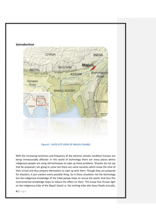
Known as the land of the seven sisters, northeast India consists of seven states i.e. Assam, Tripura, Meghalaya, Manipur, Arunachal Pradesh, Mizoram, and Nagaland. Known as Purvanchal, this part is connected to the remaining part of India through a narrow passage called Siliguri corridor between Nepal and Bangladesh. Purvanchal has its border over 2000 km and shares with Bangladesh, Bhutan, China, Myanmar and Nepal.
It is one of the most ethically and linguistically diverse region in Asia. In this part each state is diverse and is known for its distinct culture and traditions. About 220 linguistic languages are spoken in about 166 tribes of north eastern India.
Purvanchal is spread over an area of 2,55,168 sq. km. River Brahmaputra flows from here and is surrounded by plains on both sides along with Himalayan range. One of the seven state sisters, Meghalaya is the wettest region of the world. It has a humid climate predominantly with hot humid summers and mild winters. This region has rich biodiversity, heavy precipitation and high seismicity.
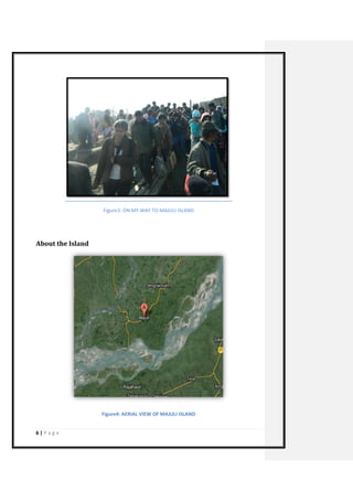
Majuli Island, the largest riverine island of the world on the bank of river Brahmaputra recites in the state of Assam. Also known as the gateway to north east India, it is renowned for its tea along with explicit flowers and rare wild animals. Rich in biodiversity, it encompasses the Barak river valley, the karbi anglong and the north cachar hills. The native and the official language of this state are Bodo and Assamese.
A popular destination for wildlife tourist, Assam is the home of the famous one horned rhinoceros, hollock gibbon, tigers and some distinct species of birds; along with a natural habitat for various migratory birds.
The commercial capital of north east India, Assam has a population of 2, 22, 94,562 people over an area of 78,523 sq. km. over 22 districts. It experiences a subtropical monsoon climate with an average rainfall of about 1500 mm per year. Though all three seasons knock the state, rainy season remains for most part of the year. Temperature there never goes beyond 35-38 degrees with a minimum of 5-6 degree Celsius.
Add of our entire team group photo
Comment [T-KGK1]:
8. 8 | P a g e
Overview
Figure5: BAMBOO HOUSES WHERE MISHING TRIBE RESIDE
World’s largest riverine island, Majuli Island, situated on the bank of river Brahmaputra is spread over an area of 875 sq. Km. 90 meters above the sea level. In the middle of Brahmaputra, Majuli Island is multifaceted in its attraction. Starting from its scenic beauty to traditional agriculture, it includes handmade art and crafts with the presence of endangered flora and fauna. It is known that Majuli Island formed due to constant earthquakes.
It is now a centre for Buddhist and Sattra devotees. One of the majestic places to visit on this planet earth Majuli Island inhabits the mishing tribe which centuries ago immigrated from Arunachal Pradesh. Apart from mishing tribe sonowal kachari and deori tribe inhabits here. According to 2001 census, population of this riverine island was 153,362 with a density of 300 individuals per square kilometre.
9. 9 | P a g e
Figure6: MAP OF MAJULI
Objective:
The main objective of my report is to find out how the Mishing tribe’s life and the surrounding area is affected due to erosional activities and other extreme climatic conditions. I will be discussing about the various problems they are facing like erosion, floods and damage of property and agriculture land; and the effect on the lives and the various ways in which they are trying to stop the erosional activities.
Linking it to TOK I will be discussing how mishing tribe will be paying for our (humans) doing in terms of land, human lives and houses.
10. 10 | P a g e
The Mishing Tribe:
Second largest group of scheduled tribe of Assam, Mishing also known as Miri are the riverine plain tribes of Assam. Having characteristics of mongloids they are the medium statured people with appealing features. Linguistically they belong to Tibeto-Burman Sub- family. They also speak Assamese, in the sense they are bilingual people. They are simple and the hostility among them very good; they treat their guests like god. Like any-other even they have some festivals like Ali-ai-ligang and Porag
11. 11 | P a g e
Figures7&8: LIFESTYLE OF MISHINGS
12. 12 | P a g e
Weather conditions
Figure9: FLOOD IN MAJULI
Majuli Island experiences a sub-tropical humid climate and is wet for almost all the months with an average rainfall of 215 cms per month. Weather here is like any other north eastern state with hot and humid summers; and cold and pleasant winters. Summers arrive in the month of March which is then knocked by monsoon in the month of July. Starting in November winters lasts till February. Extreme climatic conditions have been seen in this region with irregular rainfall patterns.
13. 13 | P a g e
There are a lot of seismic activities like soil erosion, earthquake which has led major problem to the inhabitants of this island. Due to all these seismic activities, the form of Majuli Island is changing. These activities are mainly because of change in weather and climatic conditions. Soil erosion and flooding has led to loss of significant amount of land and presently the land area has reduced to 421.65 square kilometres.
Thus largest riverine island of the world Majuli Island on the banks of river Brahmaputra is constantly facing a large number of environmental problems which has not only affecting the lives of the local people but has also reduced the land area. Erosional activity and flood are the biggest threat to this riverine island.
So to cope up with all these problems the mishing tribe of Majuli Island is continuously working on their techniques to improve them.
Since 1990 more than 35 villages have been washed away. From 1917 to 1972 annual loss of land was 1.77 square but with an increase in erosional activities the annual loss of land area has increased to 6.72 area. The reason for this is the fluctuating temperature and the unpredictable monsoon which is increasing every year. They have not only leaded to the loss of land but have also affected around 243 small and large villages.
PROBLEM OF EROSION
As discussed above numerous studies have also shown that the largest riverine island is now shrinking due to erosion of soil. Surrounded by Brahmaputra and Nuit rivers, this riverine island is reducing because of the shift of plates in the earth’s crust leading to floods. Floods are a quintessential threat to the island’s rich and indigenous cultural heritage. In the 2012 floods, Brahmaputra took away bechamara dyke, flooding salmora village. Erosion has led to a lot of pressure on the land area as one of the most common problems in India is of population.
14. 14 | P a g e
Figure10: Impact of climate change on flood characteristics of Brahmaputra
Figure11: DIAGRAM SHOWING DIFFERENT CHARCTERISTICS OF FLOOD WAVES
15. 15 | P a g e
Practice being followed
Figure12: A TOOL USED BY FOR FISHING
Having been affected by flood so many times, the small waves of Brahmaputra don’t affect them anymore. Since the last few decades their techniques have improved and are improving. So to protect themselves from flood they have divided their jobs into two parts. Firstly they try to avoid floods and second is by minimizing the effect of floods and erosional activities on the Island. So, to protect their houses from floods they have constructed raised houses with the help of bamboo sticks so that their houses do not flow with water. They always have boat with them so that during an arrival of flood they can reduce the no. of death. Third measure that villagers take is that they don’t grow crops in the months of is expected flood to lessen the loss of their effort and time.
Even the government of Assam with their disaster management team is trying to help them. They have constructed embankments and roads on the outer part of the island so the whole island is safe from floods. Main problem that arises during construction of embankment is that they brake and then there is no place for removal of water and thus the situation of water logging occurs. Protection of siltation occurs with the help of bamboo cribs, bamboo porcupines, timber dampeners and land spurs. It is unbelievable to know that an aquatic plant ipomoea aquatic was been planted as one of the steps to stop erosion of the Majuli land.
16. 16 | P a g e
The study was conducted to know about the effect on the mishing tribe with the help of two research; firstly mishing were interviewed to know about the various problems they face and how they cope up with it, next an experiment was conducted with relevance to soil and water to check the quality with the help of pH and conductivity tests.
Figure13: MISHING LADY KNITTING WOOL
17. 17 | P a g e
A study of the effect on the mishing tribe due to the erosional activities
METHOD OF INVESTIGATION
The core idea behind investigation is to know the extent to which the Mishing’s are affected. For that primary research is conducted at two levels. Firstly the houses were interviewed to know about the problems that the Mishing’s are facing with the help of interview1. Next, experiments were conducted to check the effect on soil and water quality. In the experiment conducted, samples from various places were taken to further check the area which is affected badly.
INTERVIEWS:
Figure14: INTERVIEWING THE MISHINGS
1 Appendix 1
18. 18 | P a g e
Figure15: TALKING TO THE MISHINGS
In 2 villages where various houses were interviewed (which resides in one of the Village of Majuli Island), here I got to know a lot of things which I didn’t know. The following charts represent some of the answers:
MAIN OCCUPATION
Farming
Hand-loom
weaving
fishing
19. 19 | P a g e
CROPS GROWN
Rice
Other crops
MEASURES BY GOVERNMENT
Helps a lot
Don't help
very less efficient
20. 20 | P a g e
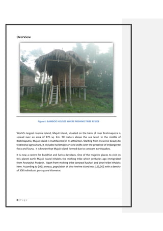
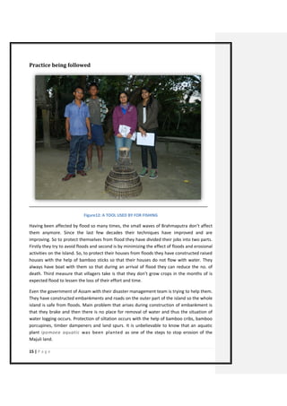
Through this I realized that Firstly government is not helping them and second thing is thati got to know the techniques they use are all ancient like raised huts, having 1 boat outside their house, planting trees on the shore to reduce erosion. These are the techniques which being used since decades, they have inherited these various techniques from their forefathers and are passing it to their heirs.
DATA EXPERIMENT:
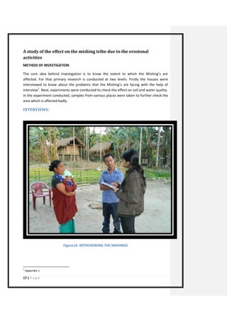
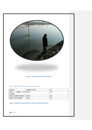
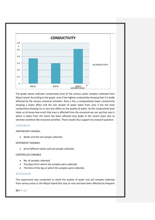
Given below are the various test conducted to check Ph and temperature of soil as well as water samples taken from Majuli island to check the effect of erosional activities in the region.
AIM:
To find how erosion of soil and water has affected the nutrient availability or the quality of water and soil in the Majuli island which in turn is negatively affecting the lives of the mishing tribe.
RESEARCH QUESTION:
To what extent has erosional activities affected the mineral content in water and soil in the Majuli Island?
HYPOTHESIS
AFFECT OF FLOODS ON THE FAMILY
No effect
Little affect
badly affected
Lost all the members
Comment [T-KGK2]: ???????
21. 21 | P a g e
I hypothesize that the region experimented is badly affected by erosional activities. Also the soil samples collected from shore will have less mineral content compared to other samples.
DATA COLLECTION
SOIL
TEMPERATURE (IN CELCIUS)
Ph
AREA 1 (INISDE THE VILLAGE)
13.5
7.0
AREA 2 (CULTIVATIONAL AREA)
11.0
5.0
AREA 3 (NEAR TO THE SHORE)
16.0
9.0
Table1: READING OF TEMPERATURE AND pH OF SOIL
Figure16: VARIOUS SOIL SAMPLES
22. 22 | P a g e
The graph above illustrates the pH levels of various soil samples collected from Majuli Island. According to graph, pH level of area 2 is lowest which makes it acidic in nature. The reason for it is that the area from where this sample is taken is an agricultural land and is fertile with lots of minerals. Second lowest reading is of the soil sample taken from area 2 which is neutral in nature. This sample is taken from the inner part of the village and this is the reason for its neutral nature. The last soil sample is taken from the shore, which is why it is alkaline in nature making it very bad to grow crops. This pH test helped me to determine one of the reasons for different soil quality. Hence helping me to add another argument in favour of the research question.
0
1
2
3
4
5
6
7
8
9
10
AREA1
AREA2
AREA3
pH
pH
X
Y
Y
samples taken
pH of samples
23. 23 | P a g e
Figure17: COLLECTING OF WATER SAMPLES
DATA PROCESSING FOR WATER SAMPLES
WATER
CONDUCTIVITY
Ph
AREA 1 (INISDE THE VILLAGE)
00.37
5.8
AREA 2 (LARGE PONDS )
00.30
4.8
AREA 3 (THE SHORE)
00.51
9.6
Table1: READING OF CONDUCTIVITY AND pH OF WATER SAMPLES
24. 24 | P a g e
The graph above illustrates pH level of various water samples collected from Majuli Island. According to the graph, pH level of area 2 is lowest which makes it acidic in nature. Next is area 1 which is second lowest and little less acidic in nature. The next water sample is alkaline in nature having a pH value of 9.6. pH test helps us to know the area which is badly affected by erosional activities. Erosional activity of water is inversely related to mineral content; As erosional activities increases the amount of mineral content decreases, vice versa. Also deposition of minerals leads to high pH value. Thus this shows that area 3 is highly affected by erosional activities and is very bad for the various marine animals living in the river, which means that the mishing tribe is badly affected, adding another point to my thesis.
0
2
4
6
8
10
12
AREA1
AREA2
AREA3
pH
pH
X
Y
Ph
samples taken
25. 25 | P a g e
The graph above indicates conductivity level of the various water samples collected from Majuli Island. According to the graph, area 3 has highest conductivity showing that it is badly affected by the various erosional activities. Area 1 has a comparatively lower conductivity showing a lower affect and the last sample of water taken from area 2 has the least conductivity showing no or very less effect on the quality of water. As the conductivity level helps us to know how much that area is affected from the erosional we can say that area 3 which is taken from the shore has been affected very badly in the recent years due to extreme condition like erosional activities. These results thus support my research question.
VARIABLES
INDEPNEDENT VARIABLE:
Water and the soil sample collected.
DEPENDENT VARIABLE
pH of different water and soil sample collected.
CONTROLLED VARIABLE
No. of samples collected.
The place form where the samples were collected.
The time of the day at which the samples were collected.
DISCUSSION
This experiment was conducted to check the quality of water and soil samples collected from various areas in the Majuli Island that may or may not have been affected by frequent
0
0.1
0.2
0.3
0.4
0.5
0.6
AREA1
AREA2
AREA3
CONDUCTIVITY
CONDUCTIVITY
X
Y
sampled areas
26. 26 | P a g e
flooding and erosional activities. According to my thesis the places near to the shore are badly affected and this is what I found from the experiment. The soil sample taken from inside the village were almost neutral and were hardly affected from erosional activities; indicating very less deposition of sediments, also focussing on the nutrients availability which is very low there. Water sample from pond is alkaline indicating that the ponds and the rivers there are not negatively affected as the sediments could not be found there also. It is good for the aquatic plants present in these water bodies as they could survive without any difficulty. Water as well as the soil sample collected from shore is alkaline which shows that this is the region which is highly affected by the extreme conditions like erosional activities which take away the top layer of the soil making it infertile. And as erosion is causing loss of land, it affects the lives of the aquatic animals living in the River Brahmaputra. All these erosional activities started occurring after the earthquake which occurred in the year 1950 which changed the course of the river. This led to a change in the climatic conditions for example change in monsoon pattern.
CONCLUSION
As hypothesized in the beginning of experiment, water and soil sample from the shore are highly affected by erosional activities in the region. I am assured about this as pH as well as the conductivity test both show the alkaline nature shore. This is because due to erosion sediments deposit in the water bodies. Water turbidity also increases making it difficult for light to enter the water. It further leads to death of aquatic animals. Thus this experiment helped me to know the nature and the presence of minerals along with the effects on surrounding environment and other flora and fauna living there. Such areas have been extensively affected by the erosional and other extreme climatic conditions occurring in the village. To conclude with the results show that with the decreasing quality of all these resources (MAJULI ISLAND), the quality of living of the mishing tribe has also decreasing and is continuously decreasing. Thus supporting my research question and prosing my point correct.
EVALUATION
The experiment was conducted on the basis of pH test and the water conductivity test; the main concern which arose during experiment was the accuracy of the data recorded after the experiment was conducted. Keeping in mind the fact that equipment were used again and again for experiment, the accuracy in the result is likely to be reduced, for instance, the conductivity meter was again and again used for all the water samples and thus there are chances of the water droplets form one sample of getting transferred to other sample. In case of pH also same container was used to check the pH of the soil samples and there are chances of some of the soil particles to mix up with the other sample leading to a less accuracy answer.
27. 27 | P a g e
Effect on the lives
Figure18: TRIBAL DANCE OF MISHINGS
Figure19: Dance of vaishnavite satras
With constant flood and erosion of land, many of the vaishnavite satras have left Majuli and gone to the mainland Assam. Satra means monastery. There were around 65 monasteries in
28. 28 | P a g e
Majuli but now only 22 of them are left due to constant floods. This has affected the cultural importance of the region also. A lot of infrastructure which was for the betterment of the tribal people has also drowned leaving barren land. This includes schools, post offices, villages and other places of public interest.
Their shelter i.e. the houses are also taken with floods manier times in spite of their constant measures like building raised houses. They then have to go from one place to another in search of shelter. It is also affected their main occupation i.e. agriculture. The crop is being affected as flood causes soil erosion and takes away all the fertile land with it. But sometimes if the people are lucky enough the flood brings fertile soil with it and helps in crop production.
Erosion is a serious environmental and ecosystem threat to the mishing people as well as the land. Earlier they never use to kill or hurt animal or birds for their own use but due to the constant floods they have to do it for their survival. So we can say that not only humans but the life of the other living creatures like birds and other aquatic animals are also affected.
YEAR
AREA (SQ. KM.)
POPULATION
POPULATION DENSITY
1901
1325.51
31219
24
1911
132.51
40420
31
1941
1324
75040
57
1951
1323.48
81001
61
1961
565.01
93541
165
1971
564.01
95618
170
1991
455.76
135378
297
2001
421.65
153362
364
Table2: showing the amount of displacement
29. 29 | P a g e
Figure20: SHOWING THE LEFT OVER MAJULI ISLAND DUE TO CONTINUOUS FLOOD AND SOIL DEGRADATION.
The above figures shows the loss of land area from 1901 to 2001 which is constantly increasing. According to data, the amount of land which was left in 2001 was just one third of the amount of land in the year 2001.
Table4: SHOWING THE NO. OF GAMILIES AFFECTED
Year
No of families’ permanently displaced
Total area eroded (in Ha)
2002
204
200
2003
100
68
2004
401
667
2005
471
257
2006
150
94
2007
564
230
1901
1911
1941
1951
1961
1971
1991
2001
30. 30 | P a g e
Figure21: SHOWING THE NO. OF FAMILIES DISPLACED AND THE LOSS OF LAND AREA
This charts show the extent to which the families and the area is being displaced every year. Graph shows the loss of families and land area from 2002 to 2007. This displacement of families is constantly increasing and is not reducing despite of the various measures that the government as well as the mishing tribe is taking. Indicating lack of efficiency and wastage of resources as government spends a lot of money to save the life of the people and thus it is high time that government starts allocating resources in a productive manner.
area
0
200
400
600
800
2002
2003
2004
2005
2006
2007
area
area
31. 31 | P a g e
Figure22: MISHING LADY WITH HER GRAND-CHILDRENS
After all my research I questioned myself why these people are suffering so much? Why is there island depleting when we are the ones who are causing global warming. Global warming is the constant rise in the temperature of oceans and the earth’s atmosphere leading to various things like climate change, floods and melting of ice. This is an example of positive feedback which can be reduced but not stopped as the stimulus works towards the change. Mishing tribe, the indigenous population of the Majuli Island is now vulnerable to the climate change. If one thinks about it, main reason for the increase in carbon footprint is because of the increased use of technology and thus increased pollution. We are the ones who are supposed to pay for this damage but the people who are so close to nature are paying for the damage that we have done to the environment. As a theory of knowledge student I would like to raise a question that is it ethically correct for the mishing tribe to lose their lives and family when we are the ones who are actually damaging the nature; An irony here Is they are protecting it, worships it as god and they are the one who are losing a jewel i.e. the Majuli Island, their homeland.
32. 32 | P a g e
Conclusion for report
EFFECT OF EXTREME CLIMATIC CONDITIONS IN THE MAJULI ISLAND
VILLAGE
LOSS OF LAND
LOSS OF LIVES
LOSS OF FLAURA AND FAUNA
33. 33 | P a g e
My main aim of the report is to illustrate the major effects of extreme conditions that Majuli Island is facing since a long period of time now. The water and the soil samples taken were tested on the basis of the pH and conductivity level. The data collected and the research shows that the quality of life in the region has reduced over the last two decades due to erosion, climatic change and the very low response to the changing conditions. The mishing tribe along with their land and houses are losing their culture. The list doesn’t stop here eri, raw silk a unique silk of Majuli Island is also expected to extinct along with the island in the next 2 decades.
One drawback of the research was that the topic is so complex that it was really hard to collect the information. Language barrier was another obstacle that I faced while collecting information as we (mishing and I) didn’t have any common language and had to use interpreter. So there might be a difference in what the mishing interpret through interpreter and what I was trying to ask them.
Word Count: 3999
34. 34 | P a g e
Bibliography
Websites
"At the river’s mercy." The Hindu. N.p., n.d. Web. 15 May 2013.
"India Together: River erosion threatens Majuli - 21 December 2007." India Together: The news in proportion. N.p., n.d. Web. 30 June 2013.
"The slow death of India's Majuli Island - Features - Al Jazeera English." Al Jazeera English - Live US, Europe, Middle East, Asia, Sports, Weather & Business News. N.p., n.d. Web. 27 Apr. 2013.
"The Telegraph - Calcutta (Kolkata) | Frontpage | Singh vows to protect Majuli." The Telegraph - Calcutta. N.p., n.d. Web. 27 Apr. 2013.
"World's largest river island washing away under flood waters - Nature - Environment." The Independent. N.p., n.d. Web. 2 June 2013.
"A Buddhist Perspective on the Environmental Problems of Majuli Island : Environment : Mingkok : Buddhistdoor." 佛門網 佛門网 Buddhist Door - 開啟佛教 大門 An Entrance to the World of Buddhism. N.p., n.d. Web. 23 Aug. 2013.
"Erosion check in mind, Majuli islanders give river 'god' status - Hindustan Times."http://www.hindustantimes.com/. N.p., n.d. Web. 2 Sept. 2013.
"Majuli tourism, Majuli Tourist Places, Majuli Travel Guide, Majuli Tourist Attractions - Native Planet." Native Planet | Travel And Tourist Information | Travel Guide | Travel Destinations | Attractions | Maps | Photos - Native Planet. N.p., n.d. Web. 28 Aug. 2013.
"Majuli | The river island of India." www.assaminfo.com - assam informations, assamese culture, tourist places in assam, education institutes in assam, festivals in assam, classifieds etc. N.p., n.d. Web. 29 Nov. 2013.
"The sorrow of Majuli." The Hindu. N.p., n.d. Web. 12 Dec. 2013.
35. 35 | P a g e
"Indian Island Majuli, World's Largest River Island, Fights For Its Biodiversity Amidst Climate Change." Youth Ki Awaaz. N.p., n.d. Web. 18 Oct. 2013.
"Majuli (India)-A lost cause or an ongoing adaptation to climate cha..." Upload & Share PowerPoint presentations, documents, infographics. N.p., n.d. Web. 15 Dec. 2013.
Majuli - Majuli Island Information. N.p., n.d. Web. 17 Oct. 2013.
"River Island of Majuli in midstream of Brahmaputra River in Assam." UNESCO World Heritage Centre. N.p., n.d. Web. 16 Dec. 2013.
"The Telegraph - Calcutta (Kolkata) | Frontpage | Villagers help save Majuli stork nests." The Telegraph - Calcutta. N.p., n.d. Web. 11 Oct. 2013.
"Mishing (Miri) Tribes of Assam - Traditional Institutions of the Miri or Mishing People | Assam Journal." Assam Journal - Jobs in Assam | Tourism | Education | Celebrities. N.p., n.d. Web. 27 may. 2013.
Research paper
Indian Academy of Sciences - Index. N.p., n.d. Web. 14 Dec. 2013.
International Journal of Engineering Science and Technology (IJEST™). N.p., n.d. Web. 17 Oct. 2013.
Lund University Publications. N.p., n.d. Web. 23 Sept. 2013.
Thought Leadership. N.p., n.d. Web. 18 June 2013.
World Bank Internet Error Page AutoRedirect. N.p., n.d. Web. 5 June 2013.
Istituto Agronomico per l'Oltremare. N.p., n.d. Web. 15 Sept. 2013.
36. 36 | P a g e
What's new | International Union for the Scientific Study of Population. N.p., n.d. Web. 18 Oct. 2013.
Journals Mani, Pankaj, Rakesh Kumar, and C. Chatterjee. erosion study of a part of majuli River-island Using remote sensing data 31 (2003): 8. Web. 23 June 2013.
Bisbas, S.p. "the environmnetalist." an experiment study of soil conservation using herbaceous plants in majuli island, assam, India (2000): 26. Web. 2 June 2013.
"Majuli Journal: Indian Island Shrinks as Brahmaputra Swells and Sways - NY Times Science | e! Science News." e! Science News | Latest science news articles. N.p., n.d. Web. 2 June 2013. Nath, Gunaram. "international journal for basic sciences and social sciences." human- Induced Threats To Biodiversity In North-East india With Special Reference To Majuli1.1 (2012): 24. Web. 5 July 2013.
Blogs
"Mishing Renaissance: Majuli:Mising tribals vulnerable to climate change,says study." Mishing Renaissance. N.p., n.d. Web. 17 Oct. 2013. Majuli (ASSAM) Flood Situation Grim. N.p., n.d. Web. 4 June 2013.
"About Assam Tourism - Travel Tourist Attractions, Interactive Assam Map | Greener Pastures." North-East India Tourism - Travel to Assam, Arunachal Pradesh And Beyond. N.p., n.d. Web. 14 Dec. 2013. N.p., 13 Dec. 2013. Web. 23 Apr. 2013. <guruess2012.wikispace.com>.
38. 38 | P a g e
APPENDIX 1
QUESTIONNAIRE
1. What is your Name?/Village
2. Since when you are residing in this Village?
3. What is your Occupation?
4. What is your Economic Support?
5. What kind of crop do you grow?
6. Can you tell us what your daily routine is?
7. Are you educated?
8. If yes, till which grade?
9. Do government provide any sort of job to the people in your village?
10. Do you have schools for girls?
11. If yes, do you send your daughter to school if you have any?
12. If no, why don’t you send her to school?
13. Do you follow child marriage?
14. What does the woman of the house do?
15. Are basic necessities near to your house?
16. Is there any kind of shortage of water or electricity?
17. Does government take any kind of measures to help you when flood occurs?
18. If yes, what kind of help is provided?
19. What kind of indigenous methods do you use?
20. Has any NGO tried to help you?
39. 39 | P a g e
21. In what did they help?
22. Was your family affected when floods occurred the last year?
23. What kind of measures did your family take?