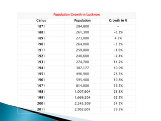
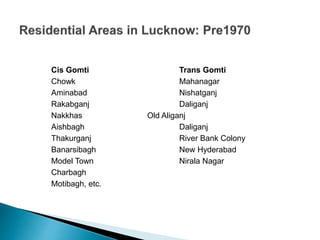
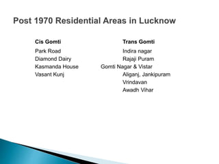
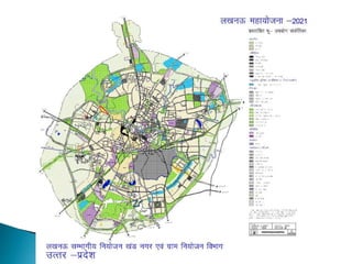
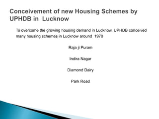
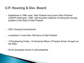
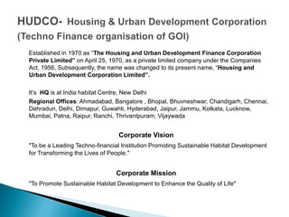
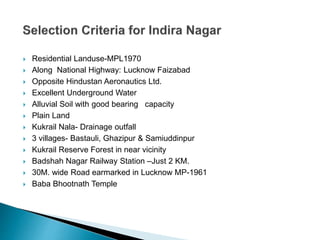
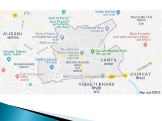
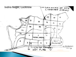
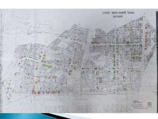
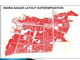
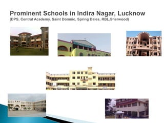
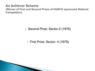
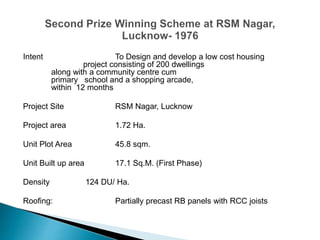
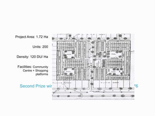
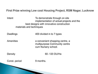
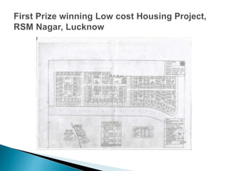
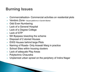
Prof. Subodh Shankar
Former Chief Architect Planner, UPHDB
An urban area or urban agglomeration, is a human settlement with high population
density and infrastructure of built environment. Urban areas are created through
urbanization and are categorized by urban morphology as cities, towns, conurbations
or suburbs
Census Definition
All places with a municipality, corporation, cantonment board or notified town area
committee, etc.
All other places which satisfied the following criteria:
i) A minimum population of 5,000;
ii) At least 75 per cent of the male main working population engaged in non-
agricultural pursuits; and
iii) A density of population of at least 400 persons per sq. km.
 Urban Population has increased from 2.58 Crore (11%) in 1901 to 37.71
Crore(31%) in 2011
 World became 50% Urbanised in 2008
 In India, Goa is the highly urbanized state with an urban population of 62.1
%; while Uttar Pradesh is just 22.28 %
 The numbers of million plus cities have increased from 9 in 1951 to 23 in
1991 and to 50 in 2011.
 Current Housing Shortage is tagged at 1.878 Crore (56% EWS and 40%
LIG)
Lucknow lies between the coordinates of 26o 30' N to 27o 10' N latitudes and
80o 30' E to 81o 13' E longitudes.
It is the capital city of the most populous state of Uttar Pradesh in India.
Lucknow is situated in the middle of Gangetic Plain and spreads on the banks
of the river Gomati, a left bank tributary of river Ganga.
It is bounded on the north by Sitapur, on the south east by the Rae Bareli, on
the north east by Barabanki, on the north west by Hardoi and on the south west
by Unnao district
Population Growth in Lucknow
Cenus Population Growth in %
1871 284,800 -
1881 261,300 -8.3%
1891 273,000 4.5%
1901 264,000 -3.3%
1911 259,800 -1.6%
1921 240,600 -7.4%
1931 274,700 14.2%
1941 387,177 40.9%
1951 496,900 28.3%
1961 595,400 19.8%
1971 814,000 36.7%
1981 1,007,604 23.8%
1991 1,669,204 65.7%
2001 2,245,509 34.5%
2011 2,902,601 29.3%
Cis Gomti Trans Gomti
Chowk Mahanagar
Aminabad Nishatganj
Rakabganj Daliganj
Nakkhas Old Aliganj
Aishbagh Daliganj
Thakurganj River Bank Colony
Banarsibagh New Hyderabad
Model Town Nirala Nagar
Charbagh
Motibagh, etc.
Cis Gomti Trans Gomti
Park Road Indira nagar
Diamond Dairy Rajaji Puram
Kasmanda House Gomti Nagar & Vistar
Vasant Kunj Aliganj, Jankipuram
Vrindavan
Awadh Vihar
To overcome the growing housing demand in Lucknow, UPHDB conceived
many housing schemes in Lucknow around 1970
Raja ji Puram
Indira Nagar
Diamond Dairy
Park Road
 Established in 1966 under ‘Uttar Pradesh Avas Evam Vikas Parishad
(UPAVP) Adhiniyam, 1965’ with the prime objective of solving the housing
problem of the State of Uttar Pradesh.
 CEO- Housing Commissioner
 Jurisdiction in more than 100 towns of Uttar Pradesh
 12 Engineering Circles, 44 divisional offices, 6 Property Zones, through out
the State
 So far developed around 3 Lakh properties
Established in 1970 as “The Housing and Urban Development Finance Corporation
Private Limited” on April 25, 1970, as a private limited company under the Companies
Act, 1956, Subsequently, the name was changed to its present name, “Housing and
Urban Development Corporation Limited”.
It’s HQ is at India habitat Centre, New Delhi
Regional Offices: Ahmadabad, Bangalore , Bhopal, Bhuvneshwar, Chandigarh, Chennai,
Dehradun, Delhi, Dimapur, Guwahti, Hyderabad, Jaipur, Jammu, Kolkata, Lucknow,
Mumbai, Patna, Raipur, Ranchi, Thrivantpuram, Vijaywada
Corporate Vision
"To be a Leading Techno-financial Institution Promoting Sustainable Habitat Development
for Transforming the Lives of People."
Corporate Mission
"To Promote Sustainable Habitat Development to Enhance the Quality of Life"
 Residential Landuse-MPL1970
 Along National Highway: Lucknow Faizabad
 Opposite Hindustan Aeronautics Ltd.
 Excellent Underground Water
 Alluvial Soil with good bearing capacity
 Plain Land
 Kukrail Nala- Drainage outfall
 3 villages- Bastauli, Ghazipur & Samiuddinpur
 Kukrail Reserve Forest in near vicinity
 Badshah Nagar Railway Station –Just 2 KM.
 30M. wide Road earmarked in Lucknow MP-1961
 Baba Bhootnath Temple
 Initial Planning only for 550 Acres . Another 700 Acres added in Vistar Yojna
 550 Acre area initially divided in to 7 sectors with network of wide roads. Later on 18
sectors added making a total of 25 sectors
 A 24m. wide arched road originated from Faizabad Road and ran parallel to it, across the
550 Acre Scheme; it terminated with 12m. Wide Kurail forest road

 As proposed in Lucknow Master Plan, 30M. Wide road planned perpendicular to Faizabad
road
 A 18M.wide road proposed in front of Bhoothnath Temple.
 Some Commercial area earmarked at the junction of Faizabad Road and Bhoothnath
Temple road. Few Shops cum Residences provided by UPHDB. CBD not planned.
 Housing for Government Employees proposed near Bhoothnath Temple
 LIG House type 1/73 proposed in Sector-3
 Green belt as earmarked in 1970 MP left at the place where Shekhar Hospital is currently located. In
subsequent MP this greenbelt dispensed with. UPHDB provided Facility Plots like Police & Fire
Station, Telephone Exchange, Nursing Homes etc.
 Roads Parallel to Faizabad Road named after Rivers like Ganga, Yamuna, Saraswati ; Vertical
roads named after Hills like Himalaya, Arawali, Neelgiri Kamkhya etc.
 Plots for Facilities like Schools and Hospital earmarked in the Layout
 Initial Planning totally based on plotted development. In eightees, 2 storied houses
proposed; disposal was a great problem
 Land Acquisition and Housing Schemes sent to HUDCO for obtaining Loans
 Properties numbered on the concept of Odd and Even. Centre line of major roads became
the division line for odd even.
 Large Plots along Faizabad Road and major Roads
 Road widening land allotted alongwith Plots adjoining Faizabad Road. FAR permitted on
total plot area
 Land use conversion of Plots adjoining Faizabad Road and in close vicinity of Bhootnath
Temple permitted on payment of land price difference between residential and
commercial.
 Concept of Bazar Street followed on commercial plots along Faizabad Road.
 Second Prize: Sector-2 (1976)
 First Prize: Sector- 4 (1979)
Intent To Design and develop a low cost housing
project consisting of 200 dwellings
along with a community centre cum
primary school and a shopping arcade,
within 12 months
Project Site RSM Nagar, Lucknow
Project area 1.72 Ha.
Unit Plot Area 45.8 sqm.
Unit Built up area 17.1 Sq.M. (First Phase)
Density 124 DU/ Ha.
Roofing: Partially precast RB panels with RCC joists
Second Prize winning Scheme at RSM Nagar, Lucknow- 1976
Project Area: 1.72 Ha
Units: 200
Density: 120 DU/ Ha
Facilities: Community
Centre + Shopping
platforms
Intent To demonstrate through on site
implementation of actual projects and the
best designs with innovative construction
materials and techniques
Dwellings 400 divided in to 7 types
Amenities a convenient shopping centre, a
multipurpose Community centre
cum Nursery school.
Density 60 -120 DU/Ha
Const. period 9 months.
 Commercialisation- Commercial activities on residential plots
 Vendors Zone- Vacant platforms in Gandhi Market
 Odd Even Numbering
 Lack of a General Hospital
 Lack of a Degree College
 Lack of STP
 NH Byepass bisecting the scheme
 Disposal of 2 storied Houses
 EWS Houses behind large Plots
 Naming of Roads- Only Arawali Marg in practice
 School Sites within housing clusters
 Lack of adequate Play Areas
 Polytechnic Chauraha
 Unplanned urban sprawl on the periphery of Indira Nagar
Revisiting Indira Nagar- a contemporary urban agglomeration in Lucknow

Revisiting Indira Nagar- a contemporary urban agglomeration in Lucknow

  • 1.
    Prof. Subodh Shankar FormerChief Architect Planner, UPHDB
  • 2.
    An urban areaor urban agglomeration, is a human settlement with high population density and infrastructure of built environment. Urban areas are created through urbanization and are categorized by urban morphology as cities, towns, conurbations or suburbs Census Definition All places with a municipality, corporation, cantonment board or notified town area committee, etc. All other places which satisfied the following criteria: i) A minimum population of 5,000; ii) At least 75 per cent of the male main working population engaged in non- agricultural pursuits; and iii) A density of population of at least 400 persons per sq. km.
  • 3.
     Urban Populationhas increased from 2.58 Crore (11%) in 1901 to 37.71 Crore(31%) in 2011  World became 50% Urbanised in 2008  In India, Goa is the highly urbanized state with an urban population of 62.1 %; while Uttar Pradesh is just 22.28 %  The numbers of million plus cities have increased from 9 in 1951 to 23 in 1991 and to 50 in 2011.  Current Housing Shortage is tagged at 1.878 Crore (56% EWS and 40% LIG)
  • 4.
    Lucknow lies betweenthe coordinates of 26o 30' N to 27o 10' N latitudes and 80o 30' E to 81o 13' E longitudes. It is the capital city of the most populous state of Uttar Pradesh in India. Lucknow is situated in the middle of Gangetic Plain and spreads on the banks of the river Gomati, a left bank tributary of river Ganga. It is bounded on the north by Sitapur, on the south east by the Rae Bareli, on the north east by Barabanki, on the north west by Hardoi and on the south west by Unnao district
  • 5.
    Population Growth inLucknow Cenus Population Growth in % 1871 284,800 - 1881 261,300 -8.3% 1891 273,000 4.5% 1901 264,000 -3.3% 1911 259,800 -1.6% 1921 240,600 -7.4% 1931 274,700 14.2% 1941 387,177 40.9% 1951 496,900 28.3% 1961 595,400 19.8% 1971 814,000 36.7% 1981 1,007,604 23.8% 1991 1,669,204 65.7% 2001 2,245,509 34.5% 2011 2,902,601 29.3%
  • 6.
    Cis Gomti TransGomti Chowk Mahanagar Aminabad Nishatganj Rakabganj Daliganj Nakkhas Old Aliganj Aishbagh Daliganj Thakurganj River Bank Colony Banarsibagh New Hyderabad Model Town Nirala Nagar Charbagh Motibagh, etc.
  • 7.
    Cis Gomti TransGomti Park Road Indira nagar Diamond Dairy Rajaji Puram Kasmanda House Gomti Nagar & Vistar Vasant Kunj Aliganj, Jankipuram Vrindavan Awadh Vihar
  • 9.
    To overcome thegrowing housing demand in Lucknow, UPHDB conceived many housing schemes in Lucknow around 1970 Raja ji Puram Indira Nagar Diamond Dairy Park Road
  • 10.
     Established in1966 under ‘Uttar Pradesh Avas Evam Vikas Parishad (UPAVP) Adhiniyam, 1965’ with the prime objective of solving the housing problem of the State of Uttar Pradesh.  CEO- Housing Commissioner  Jurisdiction in more than 100 towns of Uttar Pradesh  12 Engineering Circles, 44 divisional offices, 6 Property Zones, through out the State  So far developed around 3 Lakh properties
  • 11.
    Established in 1970as “The Housing and Urban Development Finance Corporation Private Limited” on April 25, 1970, as a private limited company under the Companies Act, 1956, Subsequently, the name was changed to its present name, “Housing and Urban Development Corporation Limited”. It’s HQ is at India habitat Centre, New Delhi Regional Offices: Ahmadabad, Bangalore , Bhopal, Bhuvneshwar, Chandigarh, Chennai, Dehradun, Delhi, Dimapur, Guwahti, Hyderabad, Jaipur, Jammu, Kolkata, Lucknow, Mumbai, Patna, Raipur, Ranchi, Thrivantpuram, Vijaywada Corporate Vision "To be a Leading Techno-financial Institution Promoting Sustainable Habitat Development for Transforming the Lives of People." Corporate Mission "To Promote Sustainable Habitat Development to Enhance the Quality of Life"
  • 12.
     Residential Landuse-MPL1970 Along National Highway: Lucknow Faizabad  Opposite Hindustan Aeronautics Ltd.  Excellent Underground Water  Alluvial Soil with good bearing capacity  Plain Land  Kukrail Nala- Drainage outfall  3 villages- Bastauli, Ghazipur & Samiuddinpur  Kukrail Reserve Forest in near vicinity  Badshah Nagar Railway Station –Just 2 KM.  30M. wide Road earmarked in Lucknow MP-1961  Baba Bhootnath Temple
  • 14.
     Initial Planningonly for 550 Acres . Another 700 Acres added in Vistar Yojna  550 Acre area initially divided in to 7 sectors with network of wide roads. Later on 18 sectors added making a total of 25 sectors  A 24m. wide arched road originated from Faizabad Road and ran parallel to it, across the 550 Acre Scheme; it terminated with 12m. Wide Kurail forest road   As proposed in Lucknow Master Plan, 30M. Wide road planned perpendicular to Faizabad road  A 18M.wide road proposed in front of Bhoothnath Temple.  Some Commercial area earmarked at the junction of Faizabad Road and Bhoothnath Temple road. Few Shops cum Residences provided by UPHDB. CBD not planned.
  • 15.
     Housing forGovernment Employees proposed near Bhoothnath Temple  LIG House type 1/73 proposed in Sector-3  Green belt as earmarked in 1970 MP left at the place where Shekhar Hospital is currently located. In subsequent MP this greenbelt dispensed with. UPHDB provided Facility Plots like Police & Fire Station, Telephone Exchange, Nursing Homes etc.  Roads Parallel to Faizabad Road named after Rivers like Ganga, Yamuna, Saraswati ; Vertical roads named after Hills like Himalaya, Arawali, Neelgiri Kamkhya etc.  Plots for Facilities like Schools and Hospital earmarked in the Layout
  • 16.
     Initial Planningtotally based on plotted development. In eightees, 2 storied houses proposed; disposal was a great problem  Land Acquisition and Housing Schemes sent to HUDCO for obtaining Loans  Properties numbered on the concept of Odd and Even. Centre line of major roads became the division line for odd even.  Large Plots along Faizabad Road and major Roads  Road widening land allotted alongwith Plots adjoining Faizabad Road. FAR permitted on total plot area  Land use conversion of Plots adjoining Faizabad Road and in close vicinity of Bhootnath Temple permitted on payment of land price difference between residential and commercial.  Concept of Bazar Street followed on commercial plots along Faizabad Road.
  • 29.
     Second Prize:Sector-2 (1976)  First Prize: Sector- 4 (1979)
  • 30.
    Intent To Designand develop a low cost housing project consisting of 200 dwellings along with a community centre cum primary school and a shopping arcade, within 12 months Project Site RSM Nagar, Lucknow Project area 1.72 Ha. Unit Plot Area 45.8 sqm. Unit Built up area 17.1 Sq.M. (First Phase) Density 124 DU/ Ha. Roofing: Partially precast RB panels with RCC joists
  • 31.
    Second Prize winningScheme at RSM Nagar, Lucknow- 1976 Project Area: 1.72 Ha Units: 200 Density: 120 DU/ Ha Facilities: Community Centre + Shopping platforms
  • 32.
    Intent To demonstratethrough on site implementation of actual projects and the best designs with innovative construction materials and techniques Dwellings 400 divided in to 7 types Amenities a convenient shopping centre, a multipurpose Community centre cum Nursery school. Density 60 -120 DU/Ha Const. period 9 months.
  • 35.
     Commercialisation- Commercialactivities on residential plots  Vendors Zone- Vacant platforms in Gandhi Market  Odd Even Numbering  Lack of a General Hospital  Lack of a Degree College  Lack of STP  NH Byepass bisecting the scheme  Disposal of 2 storied Houses  EWS Houses behind large Plots  Naming of Roads- Only Arawali Marg in practice  School Sites within housing clusters  Lack of adequate Play Areas  Polytechnic Chauraha  Unplanned urban sprawl on the periphery of Indira Nagar