A study guide filled with the easiest acronyms and memory aids to help earn your private pilot license. It covers the topics of regulations, weather, and airspace. Perfect for a student pilot or a private pilot going for a Biannual flight review.
This document provides an overview of basic navigation concepts for pilots. It covers topics like reference lines on Earth, latitude and longitude, time zones, wind corrections, and magnetic variation. The objectives are to identify these concepts and perform calculations related to time, speed, distance and aircraft navigation. Various charts and examples are provided to demonstrate applications of these navigational techniques.
Implementation of RNP_PBN Instrument Approach Procedure.pptxARVIND KUMAR SINGH
This document discusses instrument approach procedures using area navigation (RNAV) and performance-based navigation (PBN). It defines different types of instrument approach operations based on lateral and vertical navigation guidance. It describes various instrument approach procedure types including non-precision approach (NPA), approach procedure with vertical guidance (APV), and precision approach (PA). It also discusses the components, specifications, and applications of PBN concepts. Finally, it covers topics like navigation infrastructure, path terminators, satellite-based navigation, RNP approaches, temperature effects, altimeter settings, and phraseologies.
This document provides information on the aeronautical experience, flight time requirements, and currency requirements to obtain an instrument rating for airplanes. It also summarizes regulations regarding aircraft and personal documents required for IFR flight, as well as preflight planning considerations such as weather minimums, alternate airports, and fuel requirements. Additionally, it outlines standard instrument procedures such as IFR flight planning, approach types, and cruising altitudes.
The document summarizes radio navigation systems used in aircraft, including VOR (VHF Omni-directional Range) and ADF (Automatic Direction Finder). It describes how VOR uses ground-based transmitters to provide bearing information to aircraft's VOR receivers. It also explains how ADF uses non-directional beacon ground transmitters and an aircraft's loop antenna to determine bearing to the transmitter. The document provides details on components, signals, and evolution of displays for both navigation aids. It emphasizes the importance of installation, maintenance, and calibration of radio navigation avionics for safety of flight.
This document is from the Federal Aviation Administration and presents principles of flight. It covers topics like lift, drag, thrust, weight, airfoils, primary and secondary flight controls, atmospheric effects, and helicopter aerodynamics. The objectives are to identify sources of lift, forces affecting aircraft, control surfaces, and hazards to flight. It uses diagrams and examples to explain key concepts in aviation like Bernoulli's principle, Newton's laws of motion, relative wind, and the four forces acting on aircraft. It also addresses icing hazards, wing stalls, and autorotation techniques for helicopters.
The document provides an overview of the various instruments and displays pilots interact with when flying a fighter jet. It describes instruments that indicate speed like the airspeed indicator and machmeter. It also covers altitude instruments like the altimeter and radar altimeter. Other instruments discussed include the artificial horizon, vertical airspeed indicator, compass, gyrocompass, head-up display, and helmet-mounted display. The document also summarizes controls like the throttle and stick, as well as multifunction displays and flight data recorders.
Este documento describe las especificaciones para la emisión de NOTAM, incluyendo la estructura del código NOTAM, las series de NOTAM, el periodo de validez y el texto. Explica que los NOTAM proporcionan información temporal sobre peligros, cambios operativos o condiciones de instalaciones y deben emitirse de acuerdo con estándares internacionales para garantizar la seguridad de la aviación. También cubre SNOWTAM, ASHTAM y NOTAM permanentes.
This document provides an overview of the requirements for airfields to support low visibility operations including CAT II and CAT III approaches. It discusses runway characteristics such as width, slope, and markings. It also outlines the requirements for visual aids including lighting of runways, taxiways, approach lights, and signage. Finally, it addresses non-visual aids like ILS facilities and the protection of critical and sensitive areas, as well as obstacle clearance for ensuring safety during low visibility approaches and landings.
This document defines key distances related to aircraft takeoff and landing performance. It discusses:
- Screen height definitions for different aircraft types
- Definitions for runway, stopway, and clearway areas
- Declared distances including TORA, TODA, ASDA, and LDA that define available field lengths
- Required distances including TORR, TODR, and ASDR that must be met for safe takeoff and landing
- How to determine a balanced field length takeoff where TODR and ASDR are equal versus an unbalanced takeoff that takes advantage of a stopway or clearway.
Este documento describe los sistemas CNS/ATM (Comunicaciones, Navegación y Vigilancia/Gestión del Tránsito Aéreo) y su evolución hacia sistemas basados en tecnología satelital y enlaces de datos. Explica las limitaciones de los sistemas actuales y las mejoras propuestas por la OACI, incluyendo el uso del GNSS (Sistema Global de Navegación Satelital) y sus sistemas de aumentación para mejorar la precisión, integridad y disponibilidad. También describe los sistemas
Distance Measuring Equipment (DME) power point Presentation for aircraftPrabhat K.C.
Distance Measuring Equipment (DME) is a measuring device using ground and air components to determine the slant range of an aircraft from a point.
It is a radio navigation technology that measures the slant range (distance) between an aircraft and a ground station by timing the propagation delay of radio signals in the frequency band between 960 and 1215 megahertz (MHz).
The document discusses various technologies used in air traffic control and air navigation, including navigation aids like VOR, ILS, DME, RNAV, and satellite navigation. It also covers flight planning, airport charts, approach charts, and the role of the flight management system.
Cours sur le vol en VFR de nuit, réalisé dans le cadre de cours PPL(A).
Attention, ce support de formation peut contenir des erreurs éventuelles. Je vous recommande de vous rapprocher de votre FI attitré pour vos cours théoriques.
Certaines images et photographies sont issues de captures écrans depuis Google.
This document provides information about air navigation and related concepts. It discusses:
1) How air navigation differs from navigation on land and water by involving pilotage navigation with reference to visible features.
2) Key concepts in air navigation including the shape of the Earth, latitude and longitude, great circles, magnetic variation, units of measurement, and rhumb lines.
3) Worked examples and practice problems involving the calculation of distances, bearings, tracks, and conversions between true, magnetic, and compass readings.
This document provides a summary of VHF Omni-Directional Range (VOR) navigation. It describes VOR frequency, transmission, range, and identification. It also explains aircraft VOR equipment including the receiver, antenna, Course Deviation Indicator (CDI), and Radio Magnetic Indicator (RMI). The principal of VOR operation using phase comparison is outlined. Key aspects of CDI and RMI operation are defined, including rules for CDI interpretation. Common types of VOR errors and the VOR test facility are defined. Example exam questions on CDI calculations, twin pointer RMI, maximum VOR range, the 1 in 60 rule, and leading/lagging VOR signals are provided.
This presentation discusses swept wing configurations and their applications for supersonic flight. Swept wings reduce wave drag at transonic speeds by angling shock waves away from the aircraft. Swept wings were first developed in Germany in the 1930s and became prominent with aircraft like the MiG-15 and F-86. Variations include forward swept wings, which provide maneuverability but are expensive, and variable sweep wings which can change sweep angle during flight. Swept wings provide benefits like lateral stability and delaying compressibility effects at transonic speeds.
This document provides an overview of special VFR procedures and requirements. It defines special VFR as permitting flight under visual flight rules in controlled airspace when weather conditions are below the standard VFR minimums. It outlines the weather minimums, requirements for requesting special VFR clearance from air traffic control for departures and arrivals, and responsibilities of pilots regarding obstacle and terrain clearance when operating under special VFR. The document aims to explain how to safely request and utilize special VFR procedures.
The document discusses the principles and operation of VOR (VHF Omni-directional Range) navigation. It explains that VOR stations transmit radio signals that allow aircraft receivers to determine their bearing from the station and navigate radials. The station transmits both a rotating signal and fixed reference signal, and the receiver compares the phase difference to calculate the radial. It provides details on how VOR radials are displayed on charts and how pilots can navigate to or from a station based on the radial indication.
This document discusses aerodrome operating minima, which establish weather limits for safe aeroplane operations at aerodromes. It defines categories for approaches and landings based on visibility, runway visual range (RVR), decision altitude/height (DA/H), and instrument approach procedures. It also addresses factors considered in calculating operating minima, such as aircraft type, approach lighting systems, and what to do if reported visibility drops below minimums. Restricted minima with increased visibility/RVR additives apply to non-scheduled and general aviation operators.
The document defines preventive maintenance and outlines who is authorized to perform it according to FAA regulations. It specifies that holders of pilot certificates can perform preventive maintenance on aircraft they own or operate, including private pilots. The document lists the specific preventive maintenance tasks allowed by FAA regulations and provides guidance on maintenance records, required performance standards, and additional FAA resources.
CARE is a charity that provides aviation education courses in Hong Kong. It has partnered with youth organizations since 2009 and established a connection with a UK flight school in 2015. Students who complete CARE's program can receive recommendations to participate in the flight school's private pilot program. The document then describes the electronic flight displays on Airbus aircraft, including the primary flight display, navigation display, and their various modes and symbology relating to flight parameters, navigation, weather radar, and the flight management system.
A brief description of how the PBN/RNAV concept works, together with an update of the FAA implementation programs for it in the US. This presentation has been made using public information only.
Class G airspace has the fewest restrictions and is closest to the ground, while Class A airspace is the most restrictive and prohibits VFR flight. Each class has different pilot certification, equipment, and weather minimum requirements that become more stringent from Class G to Class A airspace. Special use airspaces also exist for security or military reasons and may impose additional limitations on aircraft. Knowledge of the national airspace system is essential for safe cross-country soaring flights.
The Instrument Landing System (ILS) provides precision guidance to aircraft during instrument approaches and landings. It uses radio signals from an antenna array installed at the end of runways to provide lateral and vertical guidance. The ILS allows aircraft to land safely during low visibility conditions. It consists of localizer and glide slope components that guide the aircraft to the runway centerline and a 3 degree glide path for landing. Marker beacons also help pilots locate distances from the runway threshold. The ILS enables categories of instrument approaches with minimum visibility and decision height requirements.
El documento presenta un plan de estudios para la navegación aérea, abarcando temas como las diferentes clases y sistemas de navegación, la cartografía, el uso de instrumentos como el plotter y el computador de vuelo, y conceptos como latitud, longitud y husos horarios. El curso consta de varias unidades que cubren estos temas y concluye con exámenes para evaluar el aprendizaje de los estudiantes.
Here you will find everything that you need to know about Aviation Charts right from their history, evolution and the type of charts that we use today.
A ppt for a general introduction to the Electronic flight instrument system used in modern aircraft cockpits it may be helpful for Easa part 66 module preparation.....
A pilot study is a small preliminary study conducted prior to a larger research study to test and refine aspects of the proposed research such as research instruments, sampling methods, recruitment strategies and data analysis techniques. It allows researchers to identify potential problems in their research design or methodology and make necessary revisions before embarking on the full-scale research project. Pilot studies help improve the quality, efficiency and validity of the final research study.
This study examined Cypriot pre-service teachers' perceptions of using technology based on their teaching placement experience. 10 pre-service teachers were interviewed about their technology skills, confidence, and views on integrating technology into classrooms. While the teachers were experienced computer users personally, many did not feel confident using technology for teaching. All saw benefits to technology integration but felt more training and school resources were needed to effectively implement it. Government support for technology in education was seen as inadequate. The teachers expressed interest in attending seminars to strengthen technology skills and enhance technology-supported learning.
This document outlines the purpose and process of conducting a pilot study. It defines a pilot study as an experimental investigation used to test feasibility and methods for a larger study. The main goals of a pilot study are to assess feasibility and avoid issues in a full-scale study. Key aspects addressed in a pilot study include process, resources, management, and scientific questions. Data analysis focuses on descriptive statistics and confidence intervals rather than significance testing. Results are used to determine if the full study is feasible and whether any modifications are needed.
Presentation conveys process of conducting Pilot Study in Social Sciences, Pilot Study in Commerce and Management. steps in pilot study, reasons to conduct pilot study and its importance is also mentioned.
getSayDo - how to run a pilot - brand management servicegetSayDo
The document outlines how to run a pilot of the getSayDo feedback platform. It recommends starting with a small number of customer accounts and expanding gradually over quarters. The platform allows administrators to easily upload employee data and schedule feedback requests. Customers can provide feedback in about a minute via email. Employees can view real-time feedback dashboards on any device. Using getSayDo saves significant time over traditional feedback methods and provides an immediate ROI for organizations.
The document describes the business transformation, branding and marketing, and operational consulting services offered by MAGNE Consulting Pvt. Ltd. MAGNE helps clients with retail health checks, social media strategy, community building, store operations, workforce management, and more. Their approach involves understanding clients' needs, creating a plan and roadmap, pilot testing solutions, and ongoing execution and evaluation. The document shares stories of how MAGNE has helped clients with online presence, social media strategy, business model evaluation, and reducing operational costs through stock auditing solutions.
This document describes Pathfinder, a graphic-theoretic technique that forms networks from proximity data. Pathfinder takes proximity matrices and produces networks where nodes represent concepts and links represent relationships between concepts. It uses two parameters, q and r, to determine the number and distance of links in the generated network. Pathfinder is useful for knowledge elicitation, data visualization, and analyzing citation patterns.
The document discusses the benefits of meditation for reducing stress and anxiety. Regular meditation practice can help calm the mind and body by lowering heart rate and blood pressure. Studies have shown that meditating for just 10-20 minutes per day can have significant positive impacts on both mental and physical health over time.
Graphic weather products provide an overview of large-scale weather patterns and forecasts of conditions. Key products include surface analysis charts, weather depiction charts, radar summary charts, and 12/24 hour prognostic charts. These charts identify areas of precipitation, cloud cover, winds, and pressure to help pilots anticipate weather that could impact flight.
Mahmoud R. Fath-Allah, (2002), An Econometric study on Egypt’s imports (since 1974), M.Sc.Thesis in Economics,
Cairo University, Faculty of Economics and Political Sciences (FEPS).
The document discusses several theories related to gay culture and communication, including:
1) Cass' six stage model of gay identity development - including the stages of identity confusion, comparison, tolerance, acceptance, pride, and synthesis.
2) Language variations within the gay community including accents, dialects, and vocabulary.
3) Aspects of gay subculture including terminology used to describe different types of gay men and their body types.
4) Differences in non-verbal communication and body language between gay and straight men.
5) Stereotypes often portrayed in media of gay men being overly effeminate.
This short document promotes creating presentations using Haiku Deck, a tool for making slideshows. It encourages the reader to get started making their own Haiku Deck presentation and sharing it on SlideShare. In a single sentence, it pitches the idea of using Haiku Deck to easily create and share slideshow presentations online.
This document discusses key aspects of conducting social surveys. It explains that surveys can take the form of written questionnaires or interviews. Questions can be open-ended, allowing free responses, or closed-ended with limited answers. Researchers must choose a topic suitable for a survey and form a clear aim or hypothesis to give their study focus. Concepts being studied, like social class, must be operationalized by defining observable indicators that can be measured. Pilot studies test survey questions to identify and address any issues before full data collection. Researchers aim to sample populations that allow findings to generalize to the overall group being examined.
A pilot flies planes carrying passengers or cargo between destinations. They typically need a bachelor's degree and flight training which takes about a year. The median salary for pilots is around $105,000-120,000 per year depending on the source. Their duties include flying the plane, checking safety procedures, and making reports. The job outlook is growing around 6-11% with opportunities for advancement to positions like captain or flight instructor.
Responsible use of ict brief project report - feb 2011Mel Tan
This document summarizes a pilot project in the Philippines that tested educational materials on responsible ICT use from the Asia-Pacific Economic Cooperation (APEC). A training of trainers was conducted to prepare local educators to deliver workshops. Three workshops then trained over 60 participants from different groups. Feedback found that incorporating activities helped novice ICT users learn. Videos and examples from the APEC materials engaged participants. Overall, the pilot showed the value of the materials for teaching responsible and safe ICT use.
How to become a pilot? Take a look at this slide show and know more about entrance exams, tests contents etc.
contact us on www.onestepup.in and book a career counselling session with us.
This document provides an overview of jet streams and clear air turbulence (CAT) as well as strategies for mitigating CAT risk. It defines jet streams as fast moving air currents that typically follow boundaries between hot and cold air. CAT is described as severe turbulence that can occur outside of clouds due to windshear within and around jet streams. The document outlines common types of jet streams and gives characteristics and identifiers of CAT. It then provides recommendations for flight planning to avoid CAT, such as reviewing SIGMET charts, as well as procedures to follow if CAT is encountered, such as slowing speed and notifying air traffic control.
This document provides an overview of radio relay principles and parameters that affect radio signal propagation for wireless communication systems. It discusses topics such as dispersion, multipath effects, atmospheric conditions, terrain factors, rain attenuation, and modulation techniques. Digital modulation methods like QAM are described that transmit multiple bits per symbol. System performance is affected by noise and the received signal level relative to the receiver threshold. Maintaining a positive fading margin is important for reliable communication.
Part 1 of 3, most pilots loose the basics when they start flying due to numerous reasons. Whatever your reason, don't let not coming to this seminar be one of them. This three part series will fill in the memory gaps and show you how easy it can be to understand weather systems.
The document provides guidance on how to use Stormlab radar software to aid in weather operations and decision making. It explains how to interpret Stormlab outputs like reflectivity, velocity, and storm relative motion to identify threats like tornadoes, evaluate storm reports, and determine when to activate tornado sirens. Examples of interpreting various radar features for different storm types are also included to help users understand Stormlab data.
This document provides an introduction to seismic interpretation. It begins with an overview of seismic acquisition methods both onshore and offshore. It then discusses key concepts in seismic data such as common depth points, floating datum, two-way time, and the relationship between time and depth. The document also covers seismic resolution, reflection coefficients, and examples of calculating tuning thickness. Finally, it discusses important steps for seismic interpretation including checking the line scale and orientation and interpreting major reflectors and geometries.
This document discusses various types of turbulence, visibility obstructions, and fronts that pilots may encounter. It defines turbulence as changes in wind speed and direction, and lists convection, mechanical, and orographic turbulence as the main types. Visibility can be reduced by haze, smoke, and smog. Fronts are transition zones between air masses. Warm fronts move slowly and bring long periods of low clouds and precipitation, while cold fronts have steep slopes and stronger weather like cumulonimbus clouds and turbulence. The document provides diagrams and definitions to help pilots identify and understand these atmospheric conditions.
This document provides an overview of climatology and related concepts. It defines weather as the short-term atmospheric conditions over an area, while climate describes conditions over a long period of time. It describes the layers of the atmosphere including the troposphere, stratosphere, mesosphere, and thermosphere. It also discusses atmospheric composition, temperature, pressure, and how energy is transferred through conduction, convection, and radiation.
This document provides information about climatology and the key concepts within it. It defines weather as the short-term atmospheric conditions over an area, while climate describes conditions over a long period of time (many years). It describes the layers of the atmosphere including the troposphere, stratosphere, mesosphere, and thermosphere. It also discusses atmospheric composition, temperature, pressure, and the processes involved in energy transfer within the atmosphere.
Thunderstorms are formed by cumulonimbus clouds and are characterized by lightning and thunder. They develop when certain atmospheric conditions are met, such as unstable lapse rates and sufficient water vapor. Thunderstorms can be triggered by different mechanisms like surface heating, frontal lifting, orographic lifting, and convergence. There are different types of thunderstorms including single cell, multicell, and supercells. Thunderstorms pose various hazards to aviation like turbulence, icing, hail, wind shear, lightning, tornadoes, and microbursts. Pilots can detect and avoid thunderstorms using weather radar and visual sighting, and recommended distances of avoidance depend on aircraft altitude.
AIR POLLUTION CONTROL course material by Prof S S JAHAGIRDAR,NKOCET,SOLAPUR for BE (CIVIL ) students of Solapur university. Content will be also useful for SHIVAJI and PUNE university students
The International Standard Atmosphere (ISA) provides standard conditions for pressure, temperature, and density at sea level and altitudes above sea level. At sea level, ISA conditions are 1013.25mb for pressure, +15°C for temperature, and 1225 g/m3 for density. Temperature decreases at a rate of 1.98°C for every 1000 feet of altitude increase according to the ISA lapse rate. Examples show how to calculate actual conditions compared to ISA standards.
The document provides information on Fugro Airborne Surveys' DIGHEM electromagnetic system for near-surface mapping. DIGHEM can be used from both fixed-wing aircraft and helicopters for applications such as mineral and aggregate exploration, groundwater mapping, contaminant mapping, bathymetry, and infrastructure mapping. It describes the DIGHEM system, presents case studies demonstrating its use, and compares it to other airborne electromagnetic systems.
Tunnel ventilation ppt tunnel asia 2013Hitesh Khanna
THis presentation deals with Tunnel Ventilation concepts, with special reference to T80, India's longest transportation tunnel across Pir Panjal range, connecting Jammu region to Kashmir valley
Lightning can generate temperatures over 54,000 degrees Fahrenheit and currents over 100,000 amperes. It strikes somewhere on Earth every second, killing around 100 people in the US each year. Lightning does not always strike straight down - it can hit the ground up to 10 miles from a storm. The five second rule estimates distance by counting the seconds between seeing lightning and hearing thunder, with each 5 seconds equalling about 1 mile. Proper lightning protection systems use air terminals, conductors, grounding rods, and surge protection to safely direct currents from strikes and prevent damage to buildings and electronics.
Join weather guru Scott Dennstaedt and Sporty’s John Zimmerman as they explore the ForeFlight app, the Stratus ADS-B receiver and how to use both for safer weather flying. From the basics of weather theory to real world tips about flying with ForeFlight, this webinar is packed with information you can use on your next flight.
Scott Dennstaedt, well-known for his aviation weather expertise for many years, now leads the ForeFlight team in the role of Weather Scientist. His background and experience as a CFI and research meteorologist provide a unique set of qualifications to lead you through a variety of real-world scenarios to make you a safer, better-informed pilot.
You can view the video of the complete webinar presentation here: https://www.youtube.com/watch?v=CIlpN9Dk1sE
The attached powerpoint presentation contains information about the Meteorology - 2nd unit in Open Elective - Air Pollution and Control Engineering, for affiliated institutions of Anna University.
OCE551 - Air Pollution and Control Engineering
Fire and Gas Detection System_ - Simplified_RevisedGan Chun Chet
The document discusses fire and gas detection systems on offshore platforms. It describes the importance of such systems for safety and explains different types of detection methods that can be implemented, including complete systems, sub-systems, portable detectors, and noise detectors. It also discusses the various components of detection systems like gas detectors using infrared, electrochemical, or catalytic techniques as well as flame detectors using infrared or ultraviolet. Placement of detectors and integration with control systems is also covered at a high level.
Lightning can generate temperatures over 54,000 degrees Fahrenheit and currents over 100,000 amperes. It strikes somewhere on Earth every second, killing around 100 people in the US each year. Lightning does not always strike straight down - it can hit the ground up to 10 miles from a storm. The five second rule estimates distance of a lightning strike based on the delay between seeing the flash and hearing thunder, with each five seconds equating to approximately one mile. Proper lightning protection systems use air terminals, conductors, ground terminations, and surge protection to safely direct currents from strikes and prevent damage to structures.
This document discusses seismic surveying methods used in geophysical exploration. It describes how seismic waves are generated artificially and recorded to map subsurface structures and lithologies. The main methods discussed are 2D and 3D seismic surveys. 2D surveys involve collecting seismic data along widely spaced lines, while 3D surveys acquire closely-spaced data to generate high-resolution 3D images of the subsurface. The document outlines the objectives, preparation, data acquisition, and interpretation of seismic data to infer the presence of oil and gas reservoirs.
Understanding of Self - Applied Social Psychology - Psychology SuperNotesPsychoTech Services
A proprietary approach developed by bringing together the best of learning theories from Psychology, design principles from the world of visualization, and pedagogical methods from over a decade of training experience, that enables you to: Learn better, faster!
Aggression - Applied Social Psychology - Psychology SuperNotesPsychoTech Services
A proprietary approach developed by bringing together the best of learning theories from Psychology, design principles from the world of visualization, and pedagogical methods from over a decade of training experience, that enables you to: Learn better, faster!
This presentation delves into the core principles of personality development as taught by Tim Han. Understand the importance of self-awareness, goal setting, and maintaining a positive attitude. Gain valuable tips on improving communication skills and developing emotional intelligence. Tim Han’s practical advice and holistic approach will help you embark on a transformative journey towards becoming your best self.
Covey says most people look for quick fixes. They see a big success and want to know how he did it, believing (and hoping) they can do the same following a quick bullet list.
But real change, the author says, comes not from the outside in, but from the inside out. And the most fundamental way of changing yourself is through a paradigm shift.
That paradigm shift is a new way of looking at the world. The 7 Habits of Highly Effective People presents an approach to effectiveness based on character and principles.
The first three habits indeed deal with yourself because it all starts with you. The first three habits move you from dependence from the world to the independence of making your own world.
Habits 4, 5 and 6 are about people and relationships. The will move you from independence to interdependence. Such, cooperating to achieve more than you could have by yourself.
The last habit, habit number 7, focuses on continuous growth and improvement.
ProSocial Behaviour - Applied Social Psychology - Psychology SuperNotesPsychoTech Services
A proprietary approach developed by bringing together the best of learning theories from Psychology, design principles from the world of visualization, and pedagogical methods from over a decade of training experience, that enables you to: Learn better, faster!
Stealth attraction for mens gets her with your wordsichettrisagar95
My article gives a set of techniques used by men to subtly and effectively attract women without overtly displaying their intentions. It involves using non-verbal cues, body language, and subtle psychological tactics to create intrigue and build attraction. The goal is to appear confident, mysterious, and charismatic while maintaining an air of mystery that piques the interest of the person you are trying to attract. This approach emphasizes subtlety and finesse in communication and interaction to create a powerful and lasting impression.
Stealth attraction for mens gets her with your words
Private pilot study guide
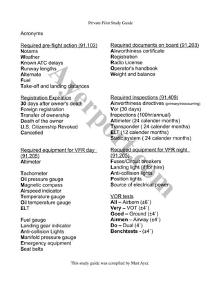
1. Private Pilot Study Guide
Acronyms
Required pre-flight action (91.103) Required documents on board (91.203)
Notams Airworthiness certificate
Weather Registration
Known ATC delays Radio License
Runway lengths Operator's handbook
Alternate Weight and balance
Fuel
Take-off and landing distances
Registration Expiration Required Inspections (91.409)
30 days after owner's death Airworthiness directives (primary/reoccurring)
Foreign registration Vor (30 days)
Transfer of ownership Inspections (100hr/annual)
Death of the owner Altimeter (24 calender months)
U.S. Citizenship Revoked Transponder ( 24 calender months)
Cancelled ELT (12 calender months)
Static system ( 24 calender months)
Required equipment for VFR day Required equipment for VFR night
(91.205) (91.205)
Altimeter Fuses/Circuit breakers
Landing light (if for hire)
Tachometer Anti-collision lights
Oil pressure gauge Position lights
Magnetic compass Source of electrical power
Airspeed indicator
Temperature gauge VOR tests
Oil temperature gauge All – Airborn (±6˚)
ELT Very – VOT (±4˚)
Good – Ground (±4˚)
Fuel gauge Airmen – Airway (±4˚)
Landing gear indicator Do – Dual (4˚)
Anti-collision Lights Benchtests - (±4˚)
Manifold pressure gauge
Emergency equipment
Seat belts
This study guide was compiled by Matt Ayer.
2. Private Pilot Study Guide
Acronyms
Types of Airspeeds
Indicated – The speed read from the instrument panel
Calibrated – Indicated corrected for position and installation error of pitot
Equivalent – Calibrated corrected air flow error at greater than 180 kts
True – Equivalent corrected for pressure and temperature.
Ground – True corrected for winds
Types of Altitudes
Indicated – The altitude read from the instrument panel
Pressure – Indicated corrected for non standard pressure
Density – Pressure corrected for non standard temperature
Absolute – Altitude above the ground level
True – Altitude above sea level
Engine System
4 cylinders
Carburetor
Horizontally opposed cylinders
Air cooled
Normally aspirated (no turbo or super charger)
Direct drive
Lycoming
Types of Hypoxia
A - Altitude – Hypoxic – Not enough oxygen
B - Blood – Stagnant – Blood not circulating
C – Cells – Hypemic – Cells aren’t carrying the oxygen molecules
D – Drugs – Histotoxic – Body tissue is poisoned by drugs and alcohol
This study guide was compiled by Matt Ayer.
3. Private Pilot Study Guide
Airspace
Dimensions Required Equipment Required from ATC Depiction on sectional
Surface to 10,000' MSL Mode C transponder, 2 way “Cleared into Bravo” Solid blue circle
B radio
C Inner ring – surface to
4000' AGL(5nm) / Outer
Mode C transponder, 2 way Establish 2 way radio
radio communications
Solid magenta circle
ring 1200' to 4000' (10nm)
D Surface to 2,500' AGL
(4nm)
2 way radio Establish 2 way radio
communications
Dashed blue circle
Types of Echo airspace
Surface – Surface to FL180 – Dashed magenta circle
Extension – Surface to FL180 – Dashed magenta box attached to a Delta airspace
Transition – 700' to FL180 – Faded magenta circle
Airway – 1200' to FL180 – Faded blue line
Domestic en route – 1200' (in Florida) to FL180 – everywhere not depicted as airspace
Offshore – 1200' to FL 180- beginning 12nm off the shore until the ADIZ
God – Above FL 600
Gulf airspace starts at the surface until any overlying airspace. It is not depicted.
Special use airspace
Warning – International waters – No permission needed
Alert – High concentration of flight activity – No permission needed
Restricted – Unusual activity – Must have permission
Military Operating Area – Seperates IFR and military traffic – No permission needed
Prohibited – Area of national security (White house) – Never enter
Controlled firing area – Not depicted – No permission needed
This study guide was compiled by Matt Ayer.
5. Private Pilot Study Guide
Weather Theory
3 factors to create thunderstorms 3 stages in a thunderstorm
• Unstable air • Cumulus (Updrafts, formation of cloud)
• Lifting action • Mature (Rain begins, anvil shape, updraft and
• Moisture downdraft)
• Dissipating (Downdrafts, microbursts)
6 types of fog 4 types of clouds
• Radiation (Calm clear nights, ground cools) • Cirrus (High altitude, made of ice crystals)
• Advection (Warm air moves over cold • Stratus (Low, horizontal formation)
surface, land moving from land to sea)
• Cumulus (Small white puffy clouds)
• Upslope (Air moves upward on a slope
cooling to its dew point) • Cumulonimbus (Towering thunderstorm
clouds)
• Ice fog (Frozen crystals are suspended in air)
• Freezing fog (Supercooled water droplets
suspended in air until freezing on a surface)
• Steam (Cool air mixing with warm, moist air
causing saturation)
Weather Services
Metar Airmets – valid 6 hours
• Issued hourly (+55) • Sierra (mountain obscurations and IFR)
• valid until the next • Tango (Moderate turbulence and
• 2 types surface winds greater that 30 knots)
1. Standard • Zulu (Light icing and freezing levels)
2. Speci (Unscheduled observation due to
weather)
Sigmets – Valid 4 hours Convective Sigmets
• Severe or greater turbulence • Severe thunderstorms
• Severe or greater icing • Surface hail ¾ inches or greater in
• Volcanic ash diameter
• Sand/ Dust Storms • Surface winds greater than or equal to
50 kts
• Tornadoes
• Embedded thunderstorms
• Lines of thunderstorms
• Precipitation affecting 40% or more of
an are of 3000 sq. miles
This study guide was compiled by Matt Ayer.
6. Private Pilot Study Guide
Weather Services
Terminal Area Forecast (TAF) Area Forecast (FA)
• Issued 4 times a day • Issued 3 times a day
• Valid 24 hours • Contains 4 parts
• Covers an area of 5 miles around the 1. Product Header (Valid 18 hours)
2. Synopsis (Valid 18 hours)
reporting airport
3. VFR clouds and weather (Valid 12 hours)
4. Outlook (Valid 6 hours)
• Covers an area of several states
Winds Aloft
• Issued 4 times a day
• Validity ranging from 6 to 24 hours
depending on the observation
Other regulations to know
Supplemental oxygen (91.211)
12,500 up to 14,000 – O2 needed after 30 mins for crew
14,000 to 15,000 – O2 must be used by crew entire flight
15,000 and above - Each occupant must be supplied with O2
Transponder required (91.215)
• Within lateral boundaries of class C airspace
• Within 30 nm of class B airspace
• When crossing the ADIZ
• When flying above 10,000 ft MSL unless below 2,500 ft AGL
ELT not required
50 nm from the training airport
Turbo-jet
Experimental
Agriculture
Research
Scheduled air carrier
1 pilot plane
Design and testing
Air racing
New aircraft delivery
Crew Training
Exhibition
This study guide was compiled by Matt Ayer.