Distance Measuring Equipment (DME) power point Presentation for aircraft
The document provides an overview of Distance Measuring Equipment (DME), which is crucial for aircraft navigation by measuring the distance from the aircraft to ground stations. It explains how DME operates using ultra-high frequencies and pulse techniques, along with its advantages such as accuracy and large coverage, and disadvantages including line-of-sight limitations and potential errors. The document outlines DME components, uses, and operational principles comprehensively.
Distance Measuring Equipment (DME) power point Presentation for aircraft
1.
“Distance Measuring Equipment
(DME)”
February29, 2020
TRIBHUVAN UNIVERSITY
INSTITUTE OF ENGINNERING
NATIONAL COLLEGE OF ENGINEERING
DEPARTMENT OF ELECTRONICS AND COMPUTER ENGINEERING
OUTLINES
• Introduction
• Theuses of a DME
• DME Equipment
• How DME work?
• Advantages of DME
• Disadvantages of DME
PREPARED BY : PRABHAT K.C.
073/BEX/201
3
4.
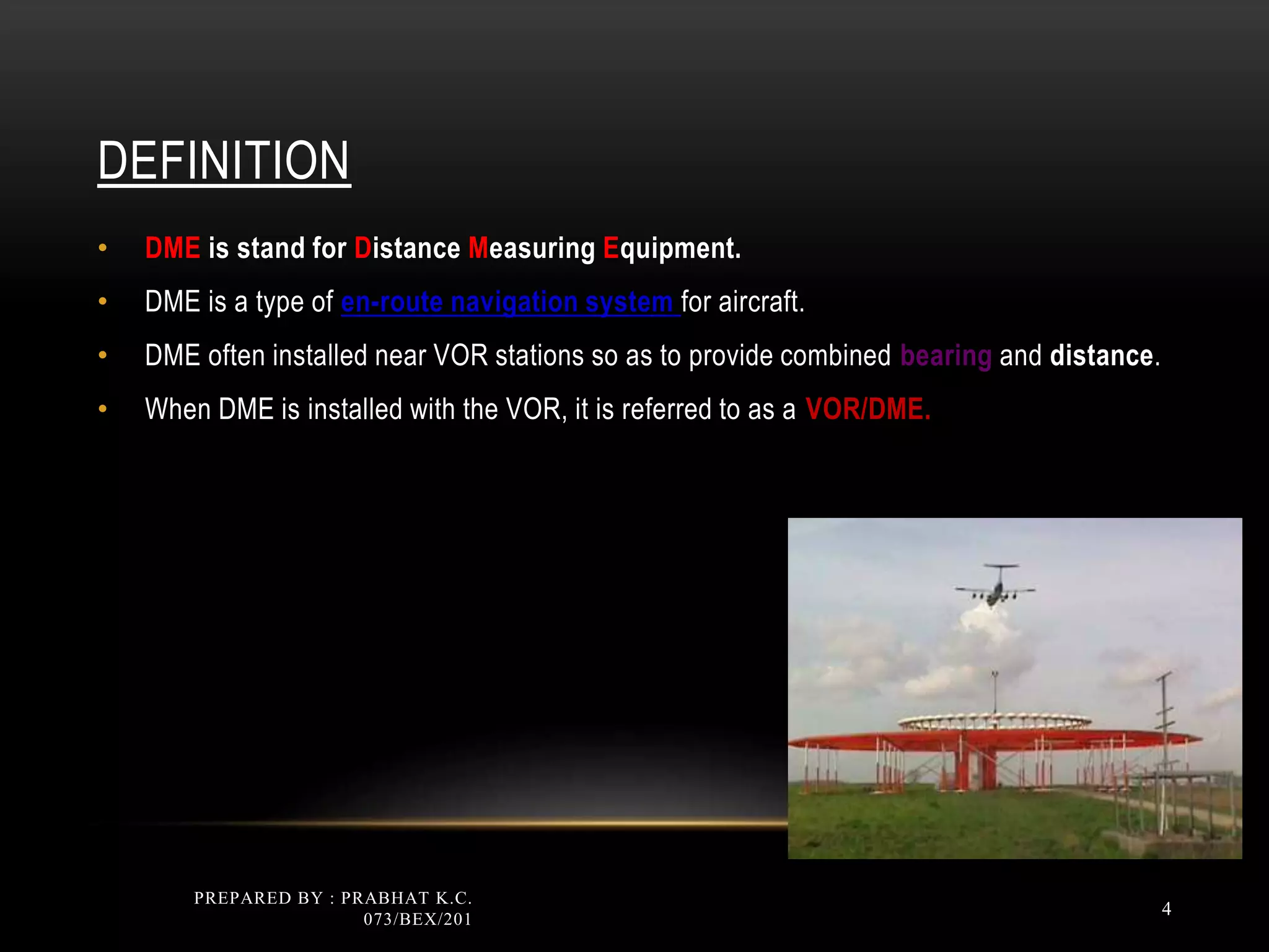
DEFINITION
• DME isstand for Distance Measuring Equipment.
• DME is a type of en-route navigation system for aircraft.
• DME often installed near VOR stations so as to provide combined bearing and distance.
• When DME is installed with the VOR, it is referred to as a VOR/DME.
PREPARED BY : PRABHAT K.C.
073/BEX/201
4
THE USES OFDME
• DME provides the physical distance from the aircraft to the ground DME transponder
expressed in Nautical Miles (NM).
• DME also calculates ground speed and the time needed to reach the station if the
aircraft is fitted with appropriate computer.
PREPARED BY : PRABHAT K.C.
073/BEX/201
6
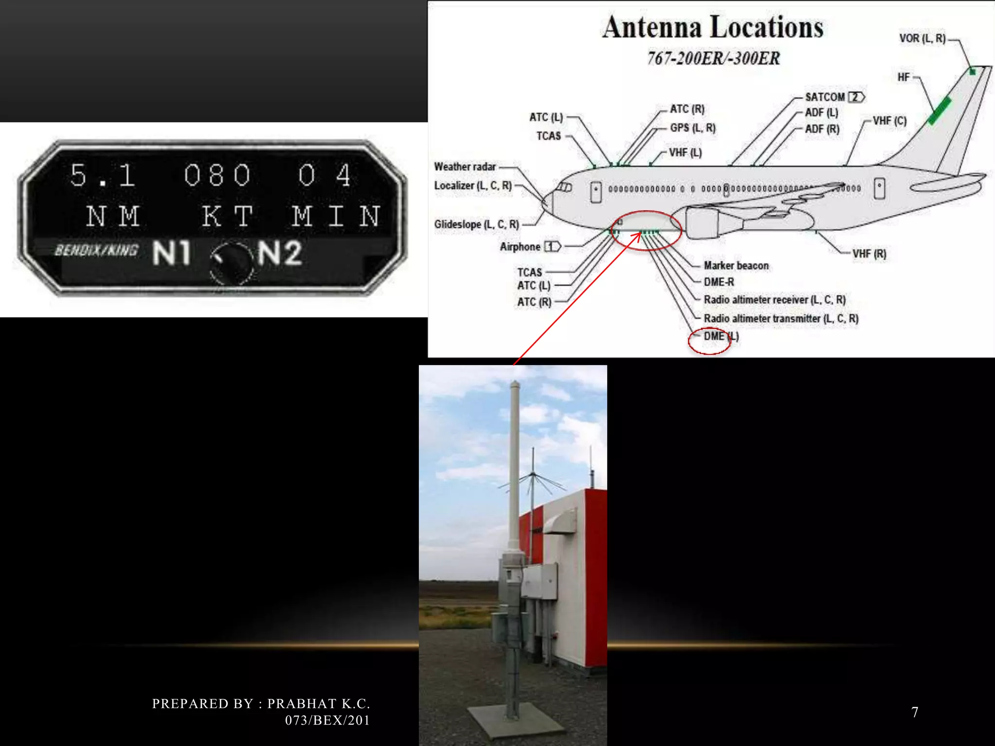
DME SYSTEM COMPONENTS:
TheDME system consists of three basic components which are:
• DME antenna on the aircraft body
• DME navigation display unit in aircraft cockpit
• DME transmitter/receiver in the ground
PREPARED BY : PRABHAT K.C.
073/BEX/201
8
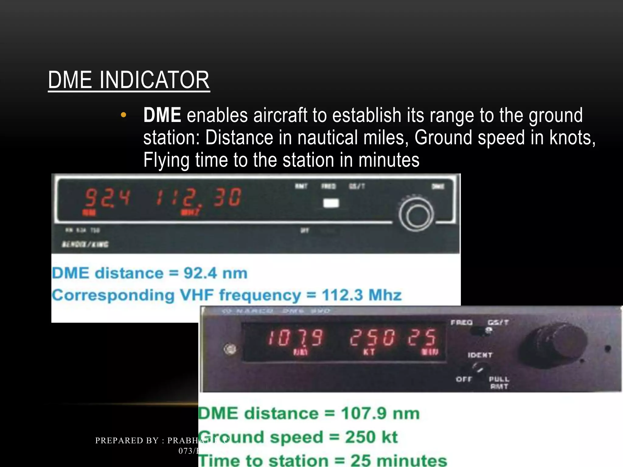
DME INDICATOR
• DMEenables aircraft to establish its range to the ground
station: Distance in nautical miles, Ground speed in knots,
Flying time to the station in minutes
PREPARED BY : PRABHAT K.C.
073/BEX/201
10
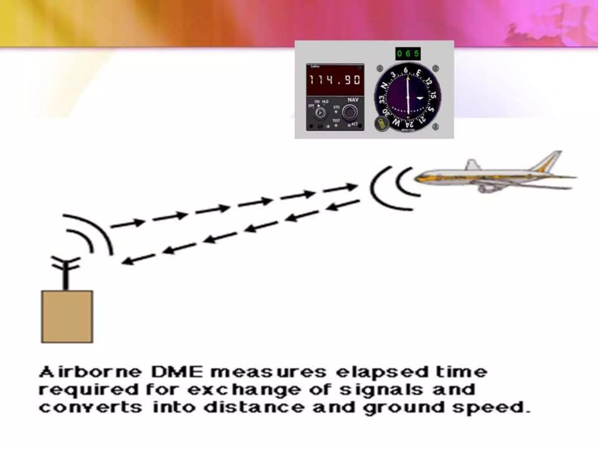
HOW DME WORKS?
•DME provides distance (slant range) from the aircraft to the
ground DME.
• DME operates on Ultra High Frequency (UHF) which is
between 962 to 1213 MHz.
• DME works based on pulse techniques, where pulse means a
single vibration of electric current.
• The aircraft’s antenna sends out paired pulses at specific
spacing.
• The ground DME station receives the pulses and then responds
with paired pulses at the same spacing but a different frequency.
PREPARED BY : PRABHAT K.C.
073/BEX/201
12
13.
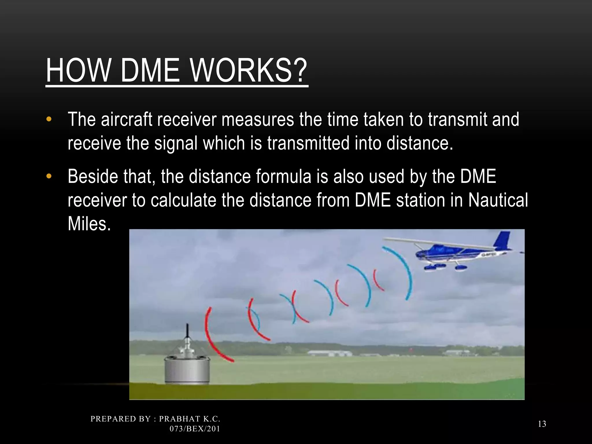
HOW DME WORKS?
•The aircraft receiver measures the time taken to transmit and
receive the signal which is transmitted into distance.
• Beside that, the distance formula is also used by the DME
receiver to calculate the distance from DME station in Nautical
Miles.
PREPARED BY : PRABHAT K.C.
073/BEX/201
13
ADVANTAGES OF DME
•DME is extremely accurate: Provide continuous and accurate indication of the slant
range distance.
• Aircraft Handling Capability: The transponder equipment should be capable of handling
100 to 200 aircrafts.
• Large coverage: DME facility provides coverage up to 200 NM.
PREPARED BY : PRABHAT K.C.
073/BEX/201
16
17.
DISADVANTAGES OF DME
•As VOR the DME is also restricted to line-of-sight transmission. For
example, the aircraft at altitude below 10’000 ft is unable to detect the DME
signal.
PREPARED BY : PRABHAT K.C.
073/BEX/201
17
18.
DISADVANTAGES OF DME
•Errors and abnormal indications:
• Slant range
• Speed and time calculation
• Ground system saturation – 100 aircraft
• System error
PREPARED BY : PRABHAT K.C.
073/BEX/201
18
19.
PREPARED BY :PRABHAT K.C.
073/BEX/201
19
Thank You !!!
Editor's Notes
#4 navigation the theory and practice of planning, controlling and recording the direction of an aircraft The basis of air navigation
is the triangle of velocities.
Navigational referring to navigation The accuracy of modern navigational
equipment is much greater than older systems.
navigational aid: a mechanical or electronic device designed to help a pilot navigate
Any type of navigational aid but particularly electronic aids, for example
ADF (automatic direction finding) and NDB
#5 Distance: a space between two places or points, or the measurement of such a space
The distance from point A to point B is 100 nm.
The distance from point A to point B on the diagram is 2 cm. The height of
the aircraft is the vertical distance, measured in feet, of the aircraft above the surface of the Earth.
The DME system is to provide continuous and accurate indication of the slant range distance (expressed in nautical miles) of an equipped ground reference point (i,e ground DME facility).
en route: on or along the way
Example: en route from New York to London or on the way from New York to London
#8 The distance measuring equipment (DME) system gives the pilots distance to a DME ground station.
The pilot can tune one DME station with the navigation control panel.
The DME-distance shows on the navigation displays unit
#9 interrogate
Transmit signals to activate a transponder Secondary surveillance
radar interrogates the aircraft equipment which responds with identification and height information.
interrogation
the transmission of signal to activate a transponder A transponder replies to interrogation by passing a four-digit code.
interrogator
ground-based surveillance radar beacon transmitter/receiver The questioner, better known as the interrogator, is fitted
on the ground, while the responder, also known as the transponder, is an airborne installation.
DME equipment is usually located in a VOR station. Other
equipment in the aircraft transmits a signal to the VOR station, which replies. The equipment in the aircraft
converts the signal into distance and also calculates ground speed and the time needed to reach the station.
nautical mile 1.852 kilometres
One knot is equal to one nautical mile per hour.
(NOTE: A nautical mile is precisely defined as the length of an arc on the
Earth’s surface subtended by an angle of one minute at the centre of the Earth.)
Airborne lifted and kept in the air by aerodynamic forces Shortly after the aircraft
becomes airborne, the undercarriage is retracted.
airborne installation airborne installation
noun a radio device in an aircraft which operates in conjunction with a ground installation The
airborne installation comprises an antenna, receiver and indicator(s).
Transponder a device in an aircraft for receiving a radio signal and automatically transmitting
a different signal so that an air traffic control station can identify the aircraft
The transponder in the aircraft comprises a transmitter and a receiver.
‘…flight trials began recently of a lowcost
hand-held IFF transponder’ [Pilot]
COMMENT: The pilot sets an identification code, or ‘squawk’, assigned by ATC, on the transponder in the aircraft.
#12 Distance measuring equipment (DME) is a system that enables an aircraft to establish its range from a ground station. It indicates continuously the distance from the selected station in nautical miles. In addition, most DMEs can display ground speed in knots and time to station in minutes.
Although a DME ground station is completely separate and independent system, it is usually collocated with VOR or seldom with NDB ground stations. By collocating VOR and DME stations, the pilot can determine aircraft position very precisely in terms of radial and distance from a VOR/DME station.
Basic operating principle
DME on-board equipment consists of a receiver and an antenna.
Ironically, while DME is a very simple system to operate, it is a fairly complex system electronically. The airborne equipment transmits a stream of interrogations to the ground station. When the interrogations are received, the ground station transmits a stream of replies to the aircraft. The airborne DME equipment receives the reply and measures the elapsed time from the time when it sent the interrogation until it received the reply. It then displays the computed distance based in time required for the signal to travel from the aircraft to the ground station and back to the aircraft.
To obtain the required information from the DME it is enough just to tune the corresponding frequency on the receiver. The DME system operates in the UHF range. A system of paring exists between VOR and DME frequencies, meaning that for every VHF VOR frequency there is only one UHF DME frequency assigned to it. So, when selecting the frequency on the DME receiver, only the corresponding VHF VOR frequency is entered and then the DME UHF frequency is automatically selected by the receiver.
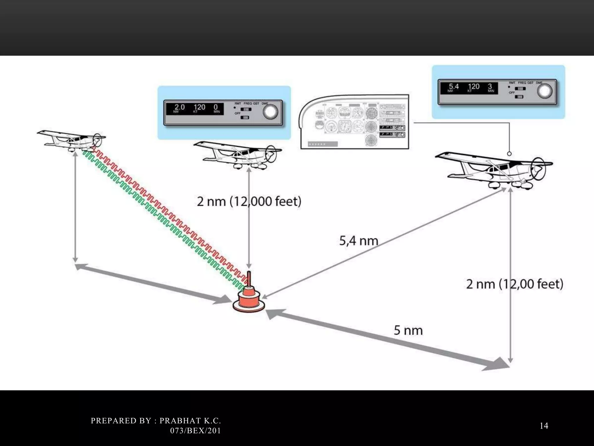
#13 Radio signal sent out from aircraft to ground station.
Ground station interprets this signal and sends back.
Equipment in aircraft measures time and converts to nautical miles.
The system operates within frequency band of 960 MHz to 1215 MHz.
The interrogation and Reply frequencies are assigned frequencies with, at least, 1 MHz separation.
The DME operates in the ultra-high frequency (UHF) band and therefore is restricted to line-of-sight transmission.
Distance measurement in DME utilizes two way travel time of the pulses and is called range time. As used in DME range time is the interval of time between transmission of an interrogation to the reception of a reply to that interrogation (exclusive of system delay and pulse pair spacing).
Notice that range time is the time required for a signal to travel a given distance twice, therefore range time for One NM is the time it takes a signal to travel actual distance of Two NM.
#14 How DME works
DME is a transponder-based radio navigation technology that measures distance by timing the propagation delay of VHF or UHF radio signals.
The DME operates by transmitting to and receiving paired pulses from the ground station.
The transmitter in the aircraft sends out very narrow pulses at a frequency of about 1,000 MHz.
These signals are received at the ground station and trigger a second transmission on a different frequency.
These reply pulses are sensed by timing circuits in the aircraft's receiver that measure the elapsed time between transmission and reception.
Electronic circuits within the radio convert this measurement to electrical signals that operate the distance and ground speed indicators.
Your airborne DME equipment receives the reply and measures the elapsed time from when it sent the interrogation until it received the reply.
It subtracts the 50 microsecond delay that the ground station introduced to come up with the round-trip time.
From this, it can figure out its exact distance from the ground station using simple arithmetic, given the fact that it takes 12.359 microseconds for a signal to go out and return one nautical mile. It then displays the computed distance on your DME readout.