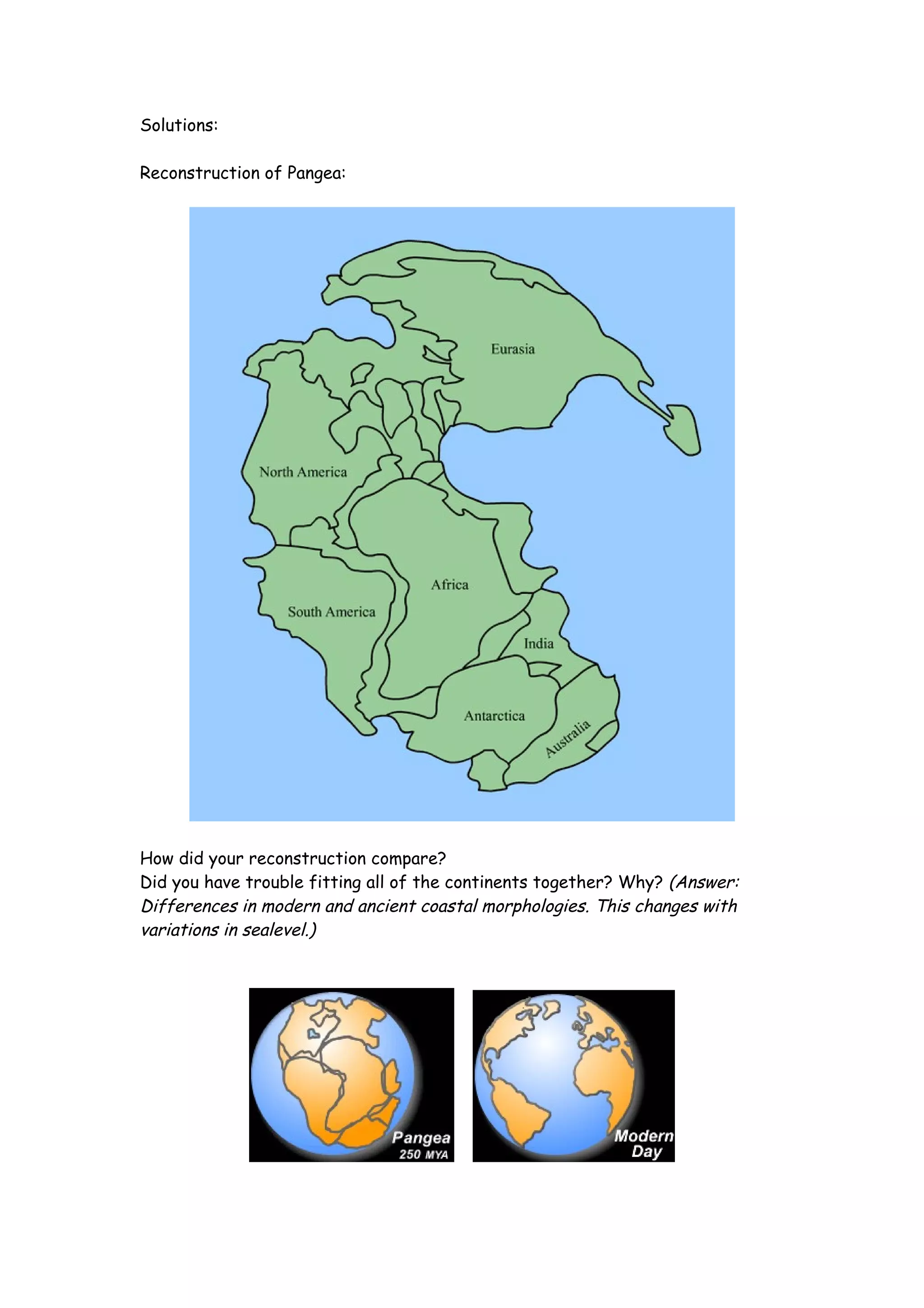
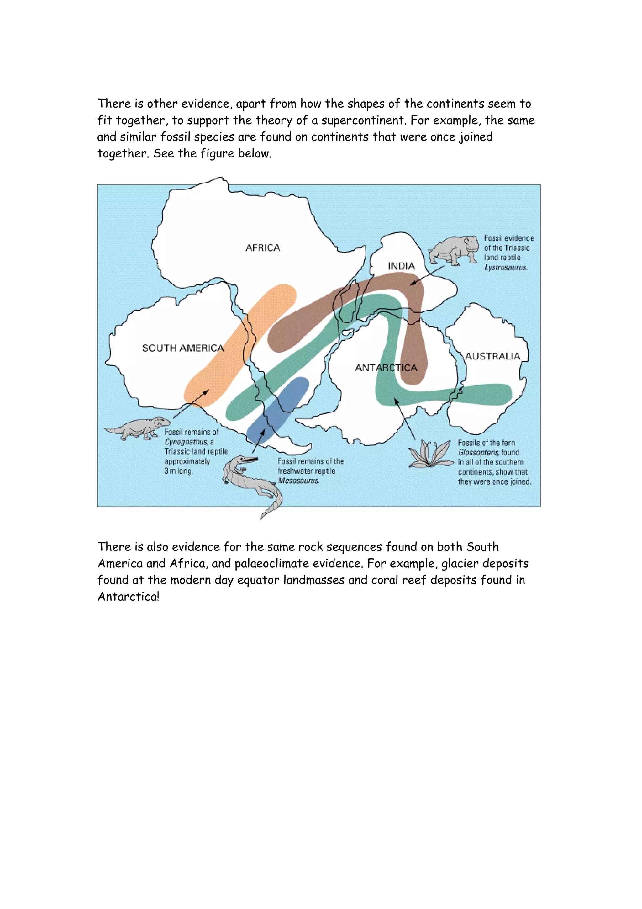
Name:___________________________ Period:____ Date:_____ Dynamic
Earth: Plate Tectonics                      Activity

                                Supercontinents!

Background:
The earth did not always look as it does today. It is believed that ~250 million
years ago (during the Palaeozoic and Mesozoic eras) all the continents were
joined together to form one “supercontinent” called Pangea. Pangea was a
roughly “C” shaped landmass that spread across the equator. The body of water
that was believed to have been enclosed within the resulting crescent has been
named the Tethys Sea. Owing to Pangaea's massive size, the inland regions
appear to have been very dry, due to the lack of rain or snowfall. The large
supercontinent would potentially have allowed terrestrial animals to migrate
freely all the way from the South Pole to the North Pole!

Exercise:

Cut out the continents from the map of how we see them today, also separate
India from continental Asia.

Try matching up the coastlines and fitting the continents together to form the
supercontinent Pangea.

Once you have arranged the continents compare your reconstruction to the one
provided.
Solutions:

Reconstruction of Pangea:


How did your reconstruction compare?
Did you have trouble fitting all of the continents together? Why? (Answer:
Differences in modern and ancient coastal morphologies. This changes with
variations in sealevel.)
There is other evidence, apart from how the shapes of the continents seem to
fit together, to support the theory of a supercontinent. For example, the same
and similar fossil species are found on continents that were once joined
together. See the figure below.


There is also evidence for the same rock sequences found on both South
America and Africa, and palaeoclimate evidence. For example, glacier deposits
found at the modern day equator landmasses and coral reef deposits found in
Antarctica!

Plates Lab

  • 1.
    Name:___________________________ Period:____ Date:_____Dynamic Earth: Plate Tectonics Activity Supercontinents! Background: The earth did not always look as it does today. It is believed that ~250 million years ago (during the Palaeozoic and Mesozoic eras) all the continents were joined together to form one “supercontinent” called Pangea. Pangea was a roughly “C” shaped landmass that spread across the equator. The body of water that was believed to have been enclosed within the resulting crescent has been named the Tethys Sea. Owing to Pangaea's massive size, the inland regions appear to have been very dry, due to the lack of rain or snowfall. The large supercontinent would potentially have allowed terrestrial animals to migrate freely all the way from the South Pole to the North Pole! Exercise: Cut out the continents from the map of how we see them today, also separate India from continental Asia. Try matching up the coastlines and fitting the continents together to form the supercontinent Pangea. Once you have arranged the continents compare your reconstruction to the one provided.
  • 3.
    Solutions: Reconstruction of Pangea: Howdid your reconstruction compare? Did you have trouble fitting all of the continents together? Why? (Answer: Differences in modern and ancient coastal morphologies. This changes with variations in sealevel.)
  • 4.
    There is otherevidence, apart from how the shapes of the continents seem to fit together, to support the theory of a supercontinent. For example, the same and similar fossil species are found on continents that were once joined together. See the figure below. There is also evidence for the same rock sequences found on both South America and Africa, and palaeoclimate evidence. For example, glacier deposits found at the modern day equator landmasses and coral reef deposits found in Antarctica!