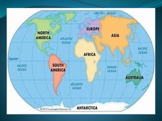
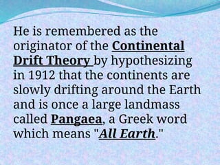
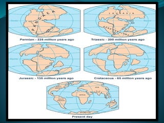
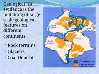
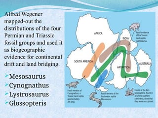
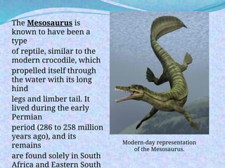
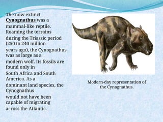
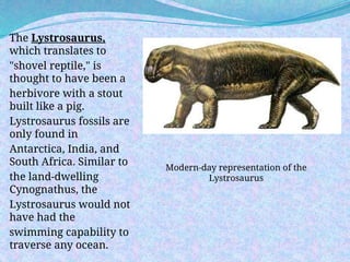
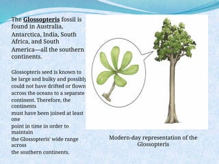
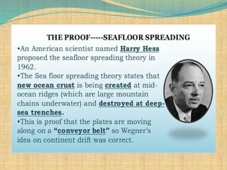
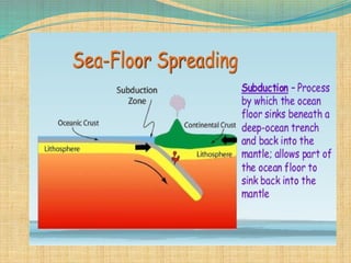
SCIENCE
10
Prayer
Dear Lord and Father of all, thank you
for today. Thank you for ways in which
you provide for all of us. For your
protection and love we thank you.
Help us to focus our hearts and minds
now on what we are about to learn.
Inspire us by your Holy Spirit as we
listen and write.
Guide us by your eternal light as we
discover more about the world around
HOUSE RULES
1. Dress properly/or wear proper
uniform
2. Mute your microphone to avoid
unwanted noise
3. Turn of your video if your
experiencing bandwidth
4. Listen attentively to your teacher
and participate in discussions
Are you
ready to
learn?
Pre-Assessment
Directions: Choose the best letter answer in
each item. Write you’re answer in your
answer sheet.
Use the given Google forms link below to
answer the Pre-Assessment.
https://docs.google.com/forms/d/e/1FAIpQLSe
32rESKRQMT9rN9YYlMOcW8pAh0N2RRw33
WAI9oC_a5O03NQ/viewform?usp=sf_link
1. What evidences do scientists use to support the
Continental Drift Theory?
A. rocks, fossils, air C. rocks, fossils, climate
B. rocks, water, ice D. rocks, fossils, human beings
2. The youngest crust is found _________ the mid-ocean
ridge.
A. far B. near C. beside D. away
3. If you are a cartographer, what would give you an idea
that the continents
were once joined?
A. ocean depth C. position of the South Pole
B. shape of the continents D. size of the Atlantic Ocean
Directions: Choose the best letter answer in each item.
Write your answer in your answer sheet.
4. What discovery provided strong support for
Continental Drift Theory?
A. Geology C. Electromagnetism
B. Fossil evidence D. Paleomagnetism
5. Which is not evidence of seafloor spreading?
A. molten magma constantly erupting C. fossil evidence
B. drilling samples of rock D. magnetic stripes
6. The magnets point north when Earth's magnetic field
has __________.
A. magnetic reversal C. mid-ocean ridge
B. reversed polarity D. normal polarity
7. Why was Alfred Wegener's Continental Drift Theory
not accepted immediately by the people during his
time?
A. He cannot explain what causes the continents to
drift.
B. He explains that South America and Africa fit
together like a puzzle.
C. He described that the rocks and mountains at the
edges of the continents were similar.
D. He explains that fossils of ancient plants such as
"Glossopteris" can be found in almost all continents.
8. Why were magnetic patterns found on the ocean
floor puzzling?
A. They did not show alternating bands of normal and
reversed polarity.
B. They showed alternating bands of normal and
reversed polarity.
C. No rocks were magnetic.
D. All rocks were magnetic.
9. What do you call the process that forms and moves
new oceanic crust?
A. magnetic reversal C. convection
B. seafloor spreading D. trenching
10. What do you call the supercontinent landmass
formed million years ago?
A. Pangaea C. Asia
B. Panthalassa D. Eurasia
11. If Australia is moving about 2cm/ year and was
drifted from the ridge by
1000km, how long ago was it when Australia was
near the ridge?
A. 50 million years C. 500 million years
B. 10 million years D. cannot be predicted
12. Which one among the continental drift pieces
of evidence mainly proves that the Cape
Mountains of South America and Africa line up
perfectly before?
A. There's an equal amount of coal deposits in each
continent and fossils.
B. The evidence from the rock layers in different
continents exactly matched.
C. The remains of the ancient plant called
Glossopteris can be found on both continents.
D. The climate of the two continents is almost the
same and with the same ancient organisms.
13. What information can be derived about Antarctica
having fossils of ancient plants and animals?
A. Antarctica drifted to the Southern hemisphere
because of the melting of glaciers that traps the plants
and animals.
B. Antarctica has a very nice climate that caused these
organisms to migrate and stay.
C. It has a tropical climate today that provides a good
environment for complex life forms.
D. Antarctica had once located near the equator.
14. He is a German Scientist who hypothesized in 1912
that continents were
once a giant landmass called Pangaea.
A. Harry Hammond Hess C. Alfred Lothar Wegener
B. Robert Dietz D. Charles Darwin
15. What did Harry Hammond Hess realize in the
1950s when his team continued exploring the ocean
floor and discovered the Mid-Atlantic Ridge?
A. He realized that the oceanic crust is older than the
continental crust.
B. He realized that Alfred Wegener's Continental Drift
Theory is not true.
C. He realized that the oceanic crusts near the Mid-
Atlantic Ridge are thicker and less dense.
D. He realized that the Earth's crust had been moving
away on each side of oceanic ridges, down the Atlantic
and Pacific Oceans.
Pre-Assessment
What was your
score?
What's In
 You have learned so far that Earth has distinct
mechanical and compositional layers. This
knowledge about the Earth's internal structure
came from the indirect observation of our
scientists through seismic activities. Scientists
learned that as continental and oceanic crusts
move, they can form geologic events such as
earthquakes, volcanoes, and mountain ranges.
SCIENCE
10
QUARTER 1
MODULE 5
Evidences of Plate Movements
Lesson 1
Continental
Drift Theory
Evidences of Plate Movements
What's New
Have you seen a
world map before?
Definitely, yes, you have seen one! Did you notice
that the eastern border of South America and the
Western part of Africa seem to fit together like a
big jigsaw puzzle?
Alfred Lothar Wegener
(1880-1930), who was a German
polar researcher, geophysicist, and
meteorologist.
He is remembered as the
originator of the Continental
Drift Theory by hypothesizing
in 1912 that the continents are
slowly drifting around the Earth
and is once a large landmass
called Pangaea, a Greek word
which means "All Earth."
 Wegener's curiosity about the idea of
drifting continents started when he
noticed the edges of South America and
Africa in a World Map could be fitted
like a jigsaw puzzle.
 Would fitting edges of continents be
enough proof that the continents are
drifting? What are the other pieces of
evidence gathered by Wegener to
support his Continental Drift Theory?
Evidence that supports
Continental Drift Theory
Geological "fit“
Fossil evidence
Geological "fit"
evidence is the
matching of large-
scale geological
features on
different
continents.
Rock terrains
Glaciers
Coal Deposits
Alfred Wegener
mapped-out the
distributions of the four
Permian and Triassic
fossil groups and used it
as biogeographic
evidence for continental
drift and land bridging.
Mesosaurus
Cynognathus
Lystrosaurus
Glossopteris
The Mesosaurus is
known to have been a
type
of reptile, similar to the
modern crocodile, which
propelled itself through
the water with its long
hind
legs and limber tail. It
lived during the early
Permian
period (286 to 258 million
years ago), and its
remains
are found solely in South
Africa and Eastern South
Modern-day representation
of the Mesosaurus.
The now extinct
Cynognathus was a
mammal-like reptile.
Roaming the terrains
during the Triassic period
(250 to 240 million
years ago), the Cynognathus
was as large as a
modern wolf. Its fossils are
found only in
South Africa and South
America. As a
dominant land species, the
Cynognathus
would not have been
capable of migrating
across the Atlantic.
Modern-day representation of
the Cynognathus.
The Lystrosaurus,
which translates to
"shovel reptile," is
thought to have been a
herbivore with a stout
built like a pig.
Lystrosaurus fossils are
only found in
Antarctica, India, and
South Africa. Similar to
the land-dwelling
Cynognathus, the
Lystrosaurus would not
have had the
swimming capability to
traverse any ocean.
Modern-day representation of the
Lystrosaurus
The Glossopteris fossil is
found in Australia,
Antarctica, India, South
Africa, and South
America—all the southern
continents.
Glossopteris seed is known to
be large and bulky and possibly
could not have drifted or flown
across the oceans to a separate
continent. Therefore, the
continents
must have been joined at least
one
point in time in order to
maintain
the Glossopteris' wide range
across
the southern continents.
Modern-day representation of the
Glossopteris
DO THIS
ACTIVITY!
A Journey From The Past To the Future!
Refer to SLM page 9-11
What you need:
 photocopy of the seven continents
 blank globe map
 Pair of scissors
 world map
 Blank Sheet of Paper
 Ball pen
A Journey From The Past To the Future!
1. Use a separate clean paper to write your
answers and observation in this activity.
2. Look carefully at the continents on a globe or a
world map.
3. Cut out carefully the picture of the landmasses.
These cutout-landmasses represent the continents
and some of the large islands of the Earth a
hundred million years ago. (Note: Before forming
"Pangaea," try to place each landmass cut out on
top of the present-day World Map to familiarize
yourself about the name of each continent and
imagine how it drifted to its present location.)
Note: Activity sheet is provided for you, do not
cut what is given on the module!
4. In the drawn circle in a separate sheet, construct the
supercontinent using the legends as your basis.(Note:
Consider the possible location and position of each
continent based on the legends before pasting it in the
blank globe map.)
5. Answer the following questions:
Q1. Do the Glossopteris fossils tell us all landmasses were
once joined together?
Q2. If Glossopteris fossils were found in Antarctica, what
was the climate of this continent before?
Q3. If the climate and the position of a place were
relative to each other, where then was the initial location
of Antarctica 250 million years ago?
Q4. Is the presence of animal fossils tells that South
America, Africa, and Antarctica were once connected?
6. Examine the giant landmass "Pangaea" and answer the
questions below:
Q5. What clues are useful in reconstructing Pangaea?
Q6. Which continents were obviously neighbors before?
Q7. Where do you think was the location of the Philippines
in Pangaea during the time when it existed?
(Note: Recall the lesson on Convergent Plate Boundaries:
Oceanic vs. Oceanic Crust)
7. Now move one continent relative to its current location.
Observe the direction of its motion carefully as it assumes it
current location and position. Do the same procedure to the
other continents.
Q8. If the continents will continue to move, try to predict
the Philippines' location 25 million years from now.
What Have You Learned?
You have learned that Alfred
Lothar Wegener's curiosity drives
him to look for evidence that
supports his Continental Drift
Theory that continents were once
connected as a big landmass called
"Pangaea."
What Have You Learned?
The Continental Drift Theory
is being supported by the
following evidence: continental
fit, matching of rocks, fossils of
ancient organisms, coal deposits
in Antarctica, ancient climates,
and glaciers carvings.
What Have You Learned?
Despite Wegener's gathered
evidence supporting his idea about
drifting continents during his time, the
scientific community rejected him for
some problems: Wegener was not a
geophysicist, he estimated the speed of
continental motion, 250 cm/year, was
unbelievably high, and he cannot explain
what causes the continents to move.
Let us see if you have
understood the essence of
the first enrichment activity.
Please answer the
assessment below.
Assessment 1
Directions: Use a separate sheet for your answers.
Write only the letter of the correct answer.
1. He was credited for the idea of Continental Drift
Theory?
A. Alfred Lothar Wegener C. Harry Hammond
Hess
B. Charles Darwin D. Robert Dietz
2. All continents were once joined together forming
a supercontinent called__________.
A. Panthalassa C. Gondwanaland
B. Laurasia D. Pangaea
3. It is possibly the most important fossil plant evidence that
continents are drifting.
A. Glossopteris C. Mesosaurus
B. Lystrosaurus D. Cynognathus
4. What are the evidence gathered by Alfred Wegener to
support his Continental Drift Theory?
A. continental fit, rocks, fossils, coal deposits, ancient
climate, and glaciers scars
B. the ancient climate of Antarctica and Africa
C. remains of dead plants and animals
D. observing the map
5. What two specific continents fit together most noticeably?
A. Africa and North America B. South America and
Africa
C. South America and Europe D. Antarctica and Africa
Lesson 2
Seafloor
Spreading
Theory
Seafloor
Spreading and
Magnetic
Reversal
The idea of continental
drift circulated in scientific
circles until World War II,
when sounding gear called
SONAR produced new
evidence of what the
seafloor
looked like. The gear,
developed in the 1930s,
bounced sound waves off
the seafloor
to determine its depth and
SONAR beam to navigate and map out
the seafloor
Activity 2: Where It All Begins?
Refer to SLM page 15-16
Let's find out: What is seafloor
spreading?
Let's use these materials:
Ages of Oceanic Lithosphere
map and diagram of the Mid-
Atlantic Ridge and Oceanic Crust
Activity 2: Where It All Begins?
What you have to do:
1. Get a clean sheet of paper to write down your
answers and observation.
2. Examine the thick line in the map below that
crosses from Northern to Southern hemispheres.
The line represents the Mid-Atlantic Ridge, which
is the longest and the most extensive chain of
underwater mountains on Earth.
Note: The colors in the map indicate the ages of the oceanic rocks per
million years.
3. Answer the following questions:
Q1. What type of plate movement or
boundary is happening in the MidAtlantic Ridge?
Choose your answer from these types of plate
boundaries: convergent divergent transform
fault
Q2. Before Q1, what molten material will
come out from the ridge?
Q3. What can you say about the ages of the
oceanic rocks near the Mid-Atlantic Ridge?
Q4. What can you say about the ages of the
oceanic rocks far from the Mid-Atlantic Ridge?
4. The figure below shows the cross-section of
the Mid-Atlantic Ridge and the Oceanic Crust.
5. Answer the following questions:
Q5. What can you say about the thickness of
the sediments near the ridge?
Choose your answer: thicker or thinner
Q6. Before Q5, what can you say about the
density of rocks near the ridge?
Choose your answer: denser or less dense
Q7. What can you say about the thickness of
the sediments far from the ridge?
Choose your answer: thicker or thinner
Q8. Prior to Q8, what can you say about the
density of rocks far from the ridge?
Choose your answer: denser or less dense
6. The diagram below shows the movement of oceanic
crust in the MidAtlantic Ridge and the different
geologic processes involved.
7. Answer the following question:
Q9. If new ocean floor is being formed near the ridge, what will
happen to
the old oceanic crust materials? Note: recall lesson on types of plate
boundaries. _______________________________________________________
Q10. What is the importance of Seafloor Spreading in
understanding the
origin of the plate movement?______________________________________
Q11. Based on your understanding about seafloor spreading theory,
is
earth getting larger and wider when plates drift away from
each other?_______________________________________________________
Assessment 2
Directions: Use a separate sheet
for your answers. Write the best
letter answer in each item. Refer
to SLM page 17
Lesson 3
Magnetic
Reversal
Magnetic Reversal
A change in the polarity of a magnetic field in wh
ich magnetic north and south are reversed.
Magnetic reversal happened many times in the
past. The occurrence of the magnetic reversal
can be explained through the magnetic patterns
in the magnetic rocks. These magnetic patterns
allow our scientists to understand the ages and
rate of movement of the materials from the mid-
oceanic ridge.
also called the "magnetic flip" of the Earth
Activity 3: The enigmatic Magnetic Reversal
Refer to SLM page 19-20
Let's find out: What is magnetic reversal?
Let's use these materials: Diagram of the Earth's
Magnetic Polarity
Let's do it this way:
1. Use a clean sheet of paper to write your answer
and observation in this
activity.
2. Analyze the diagram that shows the Earth's
magnetic polarity. The numbers indicate the ages
of the oceanic rocks in a million years, while the
legend represents the normal-reverse polarity.
3. Answer the following questions:
Q1. If magnetic reversals are recorded in the seafloor, what kind
of rock is the seafloor made?
Note: Materials rise and flow from the mid-oceanic ridge. The
material
that makes up the seafloor contains magnetic materials such as
iron.
These solidified irons in the seafloor can act like a little compass
needle and follow the Earth's magnetic
field.__________________________________________________________
Q2. What does the magnetic stripes pattern represent?
_______________________________________________________________
Note: Remember that solidified irons in the oceanic rocks can give
nformation about the direction of the Earth's magnetic field.
Q3. Is the magnetic stripe pattern on each side of the Oceanic
Ridge equal?
Q4. Are the ages of rocks on each side of the ridge the same?
Can you do this?
Activity: Pangaea Ultima (The Last
Supercontinent)
Let's find out: How does climate change related to
the movement of continents?
Let's use these materials: coloring materials
(pencil and crayons), short bond paper and a
world map showing the present location of the
continents and their movement
Let's do it this way:
1. Examine the map on the next page. It shows the present
location of each continent. The arrows indicate the direction
of each plate boundary/ continent.
If you can speed up the time 100 million years from
now, predict what will be the location of the continents?
Will they merge into one supercontinent?
 2. Draw your prediction in a separate bond paper.
Note: You might want to check this video simulation
"How Earth will look in 250 Million Years?" Youtube
link:
https://tinyurl.com/howearthwilllook250millionyear
3. Answer the following questions:
Q1. What can you say about the climate of this "Super
Continent"?
Q2. Do movements of continents play an important
factor in the so called "Climate Change"?
Q3. Will this new supercontinent be inhabitable for
mankind?
Q4. Just for fun, if you can name this Super Continent,
what will it be? Why
Remember also that your output in this activity
will be rated according to the following criteria:
 Accuracy of Details and Information 5 pts
(similar to the shapes of each continent)
 Techniques (appropriate colors, lines, shapes) 5
pts
 Neatness of Work 5 pts
Total 15pts
Assessment 3
Directions: Use a separate sheet for your
answers. Write TRUE if the statement is
correct and FALSE if the statement is incorrect.
1. The iron materials found in the seafloor can give
information about the Earth's magnetic field direction.
2. The age of rocks that comes out and flow from each side of
the oceanic ridge is equal.
3. The magnetic polarity of the Earth remains normal and does
not reverse or change.
4. The average distance traveled by the materials from each
side of the ridge is the same.
5. A magnetic reversal happens many times in the past.
IS
EVERYTHING
CLEAR?
ITS QUIZ TIME!
ASSESSMENT
Directions: Choose the best letter
answer in each item. Write only the
letter of the correct answer in a
separate sheet of paper.
Refer to SLM page 23-24
Directions: Choose the best letter answer in
each item. Write your answer in a separate
paper.
1. The idea proposed by Alfred Wegener to explain
the continental shapes and
positions is known as _____.
A. Pangaea C. Plate tectonics
B. Continental drift D. Seafloor spreading
2. Examine the figure on the right,
which two are the best examples
of different continental positions
in the past?
A. North America – South America
B. North America – Africa
C. South America – Asia
D. South America – Africa
Pangaea from Wikimedia Commons
3. Early observers thought continents might have
been joined based on what
observation?
A. rocks and fossils C. magnetism .
B. earthquakes D. coastline
4. Early observers thought continents might have
been joined based on what observation?
A. rocks and fossils C. magnetism .
B. earthquakes D. coastline
5. Wegener suggested that coal beds discovered in
Antarctica indicated that this
continent was
A. once underwater. C. always frozen.
B. once near the equator. D. part of Africa
6. In the figure above, what is the age of the
seafloor off of the Bahamas?
A. younger than 9.6 million years C. 33.0 – 83.0
million years
B. 9.6 – 33.0 million years D. 83.0 – 141.9 million
year
Study the Mid-Atlantic figure to answer items 7-8
7. In the figure above, what is the approximate age of
the seafloor off the north coast of Spain?
A. younger than 9.6 million years C. 33.0 – 83.0 million
years
B. 9.6 – 33.0 million years D. 83.0 – 141.9 million years
8. Peer scientists reviewing Wegener's hypothesis of
continental drift rejected his notion
because____________.
A. his evidence was too few to make a valid conclusion.
B. he did not explain how continents move and what
moves them.
C. his evidence was not clear in showing how
continents were joined.
D. he lied by including false evidence.
9. ___________ help explain why Earth is not getting
any larger even though the tectonic plates are
always moving.
A. Earthquakes C. Subduction zones
B. Fossils D. Volcanoes
10. If there are MORE mid-ocean ridges than
subduction zones, what happens to the ocean?
A. It gets larger. C. It gets smaller.
B. It sinks. D. Nothing will change.
11. What do ancient glacier scars found in rock
surfaces in Africa tells about its climate in the past?
A. The continents have not moved.
B.Africa has always been near the equator.
C.Africa was once in an area of the Earth that had a
very cold climate.
D.Africa was once covered with ice sheets but did not
move ever since.
12. Which of the following increases with distance
from the mid-oceanic ridge?
A. The age of oceanic lithosphere. C. The thickness of
the lithosphere.
B. The density of oceanic lithosphere. D. All (A, B, & C)
13. The Seafloor Spreading Theory states that
________________.
A. all continents are drifting.
B. ages of rocks near a ridge are older than the
ones far from it.
C. fossils of plants and animals are found in
almost all continents.
D. hot and less dense material from below the
Earth's crust rises towards the surface at the
mid-oceanic ridge.
14. What can you say about the rate of movement of
materials coming out from the mid-oceanic ridge and
the materials sinking in the subduction zone?
A. The rising of the materials from the ridge is slower
than in the subduction zone.
B. The movement of the materials in both ridge and
subduction zone is the same.
C. The rising of the materials from the ridge is faster
than in the subduction zone.
D. There is no much movement of materials happening
in both the ridge and subduction zone.
15. What strong evidence discovered by our
scientist that Earth's magnetic reversal had been
happening in the past?
A. The magnetic reversal occurrence is supported
by magnetic patterns in magnetic rocks found on
the ocean floor.
B. The ages of the rocks on the ocean floor are
constantly changing.
C. The magnetic field of the Earth becomes weaker.
D. The Earth's magnetic field is fluctuating.
YOU
CAN
DO
THIS!
Additional Activities
To remember more about Alfred Wegener and
Harry Hess works, you might want to sing the song
"Wegener was his name" by Mr. Parr to the tune of
the song
"One-call away" from Youtube.com. Here is the link
to that song:
 https://tinyurl.com/wegenerwashisname
Wait, there's more! You might want to sing this
song too "Pangaea's Moving Farther Apart Again
Song," link:
https://tinyurl.com/pangaeamovingpartagain
How I Rate My Self…
Before you return this module to
your teacher, kindly copy and fill
out the Self-rating table adapted
from Valdoz (2017).
Refer to SLM page 25
DO YOU
HAVE ANY
QUESTION?
THANK YOU FOR
LISTENING :)

GRADE 10 Science QUARTER 1 module 5.pptx

  • 1.
  • 2.
    Prayer Dear Lord andFather of all, thank you for today. Thank you for ways in which you provide for all of us. For your protection and love we thank you. Help us to focus our hearts and minds now on what we are about to learn. Inspire us by your Holy Spirit as we listen and write. Guide us by your eternal light as we discover more about the world around
  • 4.
    HOUSE RULES 1. Dressproperly/or wear proper uniform 2. Mute your microphone to avoid unwanted noise 3. Turn of your video if your experiencing bandwidth 4. Listen attentively to your teacher and participate in discussions
  • 5.
  • 6.
    Pre-Assessment Directions: Choose thebest letter answer in each item. Write you’re answer in your answer sheet. Use the given Google forms link below to answer the Pre-Assessment. https://docs.google.com/forms/d/e/1FAIpQLSe 32rESKRQMT9rN9YYlMOcW8pAh0N2RRw33 WAI9oC_a5O03NQ/viewform?usp=sf_link
  • 7.
    1. What evidencesdo scientists use to support the Continental Drift Theory? A. rocks, fossils, air C. rocks, fossils, climate B. rocks, water, ice D. rocks, fossils, human beings 2. The youngest crust is found _________ the mid-ocean ridge. A. far B. near C. beside D. away 3. If you are a cartographer, what would give you an idea that the continents were once joined? A. ocean depth C. position of the South Pole B. shape of the continents D. size of the Atlantic Ocean Directions: Choose the best letter answer in each item. Write your answer in your answer sheet.
  • 8.
    4. What discoveryprovided strong support for Continental Drift Theory? A. Geology C. Electromagnetism B. Fossil evidence D. Paleomagnetism 5. Which is not evidence of seafloor spreading? A. molten magma constantly erupting C. fossil evidence B. drilling samples of rock D. magnetic stripes 6. The magnets point north when Earth's magnetic field has __________. A. magnetic reversal C. mid-ocean ridge B. reversed polarity D. normal polarity
  • 9.
    7. Why wasAlfred Wegener's Continental Drift Theory not accepted immediately by the people during his time? A. He cannot explain what causes the continents to drift. B. He explains that South America and Africa fit together like a puzzle. C. He described that the rocks and mountains at the edges of the continents were similar. D. He explains that fossils of ancient plants such as "Glossopteris" can be found in almost all continents.
  • 10.
    8. Why weremagnetic patterns found on the ocean floor puzzling? A. They did not show alternating bands of normal and reversed polarity. B. They showed alternating bands of normal and reversed polarity. C. No rocks were magnetic. D. All rocks were magnetic. 9. What do you call the process that forms and moves new oceanic crust? A. magnetic reversal C. convection B. seafloor spreading D. trenching
  • 11.
    10. What doyou call the supercontinent landmass formed million years ago? A. Pangaea C. Asia B. Panthalassa D. Eurasia 11. If Australia is moving about 2cm/ year and was drifted from the ridge by 1000km, how long ago was it when Australia was near the ridge? A. 50 million years C. 500 million years B. 10 million years D. cannot be predicted
  • 12.
    12. Which oneamong the continental drift pieces of evidence mainly proves that the Cape Mountains of South America and Africa line up perfectly before? A. There's an equal amount of coal deposits in each continent and fossils. B. The evidence from the rock layers in different continents exactly matched. C. The remains of the ancient plant called Glossopteris can be found on both continents. D. The climate of the two continents is almost the same and with the same ancient organisms.
  • 13.
    13. What informationcan be derived about Antarctica having fossils of ancient plants and animals? A. Antarctica drifted to the Southern hemisphere because of the melting of glaciers that traps the plants and animals. B. Antarctica has a very nice climate that caused these organisms to migrate and stay. C. It has a tropical climate today that provides a good environment for complex life forms. D. Antarctica had once located near the equator. 14. He is a German Scientist who hypothesized in 1912 that continents were once a giant landmass called Pangaea. A. Harry Hammond Hess C. Alfred Lothar Wegener B. Robert Dietz D. Charles Darwin
  • 14.
    15. What didHarry Hammond Hess realize in the 1950s when his team continued exploring the ocean floor and discovered the Mid-Atlantic Ridge? A. He realized that the oceanic crust is older than the continental crust. B. He realized that Alfred Wegener's Continental Drift Theory is not true. C. He realized that the oceanic crusts near the Mid- Atlantic Ridge are thicker and less dense. D. He realized that the Earth's crust had been moving away on each side of oceanic ridges, down the Atlantic and Pacific Oceans.
  • 15.
  • 16.
    What's In  Youhave learned so far that Earth has distinct mechanical and compositional layers. This knowledge about the Earth's internal structure came from the indirect observation of our scientists through seismic activities. Scientists learned that as continental and oceanic crusts move, they can form geologic events such as earthquakes, volcanoes, and mountain ranges.
  • 17.
  • 18.
  • 19.
    What's New Have youseen a world map before?
  • 21.
    Definitely, yes, youhave seen one! Did you notice that the eastern border of South America and the Western part of Africa seem to fit together like a big jigsaw puzzle?
  • 22.
    Alfred Lothar Wegener (1880-1930),who was a German polar researcher, geophysicist, and meteorologist.
  • 23.
    He is rememberedas the originator of the Continental Drift Theory by hypothesizing in 1912 that the continents are slowly drifting around the Earth and is once a large landmass called Pangaea, a Greek word which means "All Earth."
  • 25.
     Wegener's curiosityabout the idea of drifting continents started when he noticed the edges of South America and Africa in a World Map could be fitted like a jigsaw puzzle.  Would fitting edges of continents be enough proof that the continents are drifting? What are the other pieces of evidence gathered by Wegener to support his Continental Drift Theory?
  • 26.
    Evidence that supports ContinentalDrift Theory Geological "fit“ Fossil evidence
  • 27.
    Geological "fit" evidence isthe matching of large- scale geological features on different continents. Rock terrains Glaciers Coal Deposits
  • 28.
    Alfred Wegener mapped-out the distributionsof the four Permian and Triassic fossil groups and used it as biogeographic evidence for continental drift and land bridging. Mesosaurus Cynognathus Lystrosaurus Glossopteris
  • 29.
    The Mesosaurus is knownto have been a type of reptile, similar to the modern crocodile, which propelled itself through the water with its long hind legs and limber tail. It lived during the early Permian period (286 to 258 million years ago), and its remains are found solely in South Africa and Eastern South Modern-day representation of the Mesosaurus.
  • 30.
    The now extinct Cynognathuswas a mammal-like reptile. Roaming the terrains during the Triassic period (250 to 240 million years ago), the Cynognathus was as large as a modern wolf. Its fossils are found only in South Africa and South America. As a dominant land species, the Cynognathus would not have been capable of migrating across the Atlantic. Modern-day representation of the Cynognathus.
  • 31.
    The Lystrosaurus, which translatesto "shovel reptile," is thought to have been a herbivore with a stout built like a pig. Lystrosaurus fossils are only found in Antarctica, India, and South Africa. Similar to the land-dwelling Cynognathus, the Lystrosaurus would not have had the swimming capability to traverse any ocean. Modern-day representation of the Lystrosaurus
  • 32.
    The Glossopteris fossilis found in Australia, Antarctica, India, South Africa, and South America—all the southern continents. Glossopteris seed is known to be large and bulky and possibly could not have drifted or flown across the oceans to a separate continent. Therefore, the continents must have been joined at least one point in time in order to maintain the Glossopteris' wide range across the southern continents. Modern-day representation of the Glossopteris
  • 33.
  • 34.
    A Journey FromThe Past To the Future! Refer to SLM page 9-11 What you need:  photocopy of the seven continents  blank globe map  Pair of scissors  world map  Blank Sheet of Paper  Ball pen
  • 35.
    A Journey FromThe Past To the Future! 1. Use a separate clean paper to write your answers and observation in this activity. 2. Look carefully at the continents on a globe or a world map. 3. Cut out carefully the picture of the landmasses. These cutout-landmasses represent the continents and some of the large islands of the Earth a hundred million years ago. (Note: Before forming "Pangaea," try to place each landmass cut out on top of the present-day World Map to familiarize yourself about the name of each continent and imagine how it drifted to its present location.) Note: Activity sheet is provided for you, do not cut what is given on the module!
  • 36.
    4. In thedrawn circle in a separate sheet, construct the supercontinent using the legends as your basis.(Note: Consider the possible location and position of each continent based on the legends before pasting it in the blank globe map.) 5. Answer the following questions: Q1. Do the Glossopteris fossils tell us all landmasses were once joined together? Q2. If Glossopteris fossils were found in Antarctica, what was the climate of this continent before? Q3. If the climate and the position of a place were relative to each other, where then was the initial location of Antarctica 250 million years ago? Q4. Is the presence of animal fossils tells that South America, Africa, and Antarctica were once connected?
  • 37.
    6. Examine thegiant landmass "Pangaea" and answer the questions below: Q5. What clues are useful in reconstructing Pangaea? Q6. Which continents were obviously neighbors before? Q7. Where do you think was the location of the Philippines in Pangaea during the time when it existed? (Note: Recall the lesson on Convergent Plate Boundaries: Oceanic vs. Oceanic Crust) 7. Now move one continent relative to its current location. Observe the direction of its motion carefully as it assumes it current location and position. Do the same procedure to the other continents. Q8. If the continents will continue to move, try to predict the Philippines' location 25 million years from now.
  • 38.
    What Have YouLearned? You have learned that Alfred Lothar Wegener's curiosity drives him to look for evidence that supports his Continental Drift Theory that continents were once connected as a big landmass called "Pangaea."
  • 39.
    What Have YouLearned? The Continental Drift Theory is being supported by the following evidence: continental fit, matching of rocks, fossils of ancient organisms, coal deposits in Antarctica, ancient climates, and glaciers carvings.
  • 40.
    What Have YouLearned? Despite Wegener's gathered evidence supporting his idea about drifting continents during his time, the scientific community rejected him for some problems: Wegener was not a geophysicist, he estimated the speed of continental motion, 250 cm/year, was unbelievably high, and he cannot explain what causes the continents to move.
  • 41.
    Let us seeif you have understood the essence of the first enrichment activity. Please answer the assessment below.
  • 42.
    Assessment 1 Directions: Usea separate sheet for your answers. Write only the letter of the correct answer. 1. He was credited for the idea of Continental Drift Theory? A. Alfred Lothar Wegener C. Harry Hammond Hess B. Charles Darwin D. Robert Dietz 2. All continents were once joined together forming a supercontinent called__________. A. Panthalassa C. Gondwanaland B. Laurasia D. Pangaea
  • 43.
    3. It ispossibly the most important fossil plant evidence that continents are drifting. A. Glossopteris C. Mesosaurus B. Lystrosaurus D. Cynognathus 4. What are the evidence gathered by Alfred Wegener to support his Continental Drift Theory? A. continental fit, rocks, fossils, coal deposits, ancient climate, and glaciers scars B. the ancient climate of Antarctica and Africa C. remains of dead plants and animals D. observing the map 5. What two specific continents fit together most noticeably? A. Africa and North America B. South America and Africa C. South America and Europe D. Antarctica and Africa
  • 44.
  • 45.
    Seafloor Spreading and Magnetic Reversal The ideaof continental drift circulated in scientific circles until World War II, when sounding gear called SONAR produced new evidence of what the seafloor looked like. The gear, developed in the 1930s, bounced sound waves off the seafloor to determine its depth and SONAR beam to navigate and map out the seafloor
  • 48.
    Activity 2: WhereIt All Begins? Refer to SLM page 15-16 Let's find out: What is seafloor spreading? Let's use these materials: Ages of Oceanic Lithosphere map and diagram of the Mid- Atlantic Ridge and Oceanic Crust
  • 49.
    Activity 2: WhereIt All Begins? What you have to do: 1. Get a clean sheet of paper to write down your answers and observation. 2. Examine the thick line in the map below that crosses from Northern to Southern hemispheres. The line represents the Mid-Atlantic Ridge, which is the longest and the most extensive chain of underwater mountains on Earth.
  • 50.
    Note: The colorsin the map indicate the ages of the oceanic rocks per million years.
  • 51.
    3. Answer thefollowing questions: Q1. What type of plate movement or boundary is happening in the MidAtlantic Ridge? Choose your answer from these types of plate boundaries: convergent divergent transform fault Q2. Before Q1, what molten material will come out from the ridge? Q3. What can you say about the ages of the oceanic rocks near the Mid-Atlantic Ridge? Q4. What can you say about the ages of the oceanic rocks far from the Mid-Atlantic Ridge?
  • 52.
    4. The figurebelow shows the cross-section of the Mid-Atlantic Ridge and the Oceanic Crust. 5. Answer the following questions: Q5. What can you say about the thickness of the sediments near the ridge? Choose your answer: thicker or thinner
  • 53.
    Q6. Before Q5,what can you say about the density of rocks near the ridge? Choose your answer: denser or less dense Q7. What can you say about the thickness of the sediments far from the ridge? Choose your answer: thicker or thinner Q8. Prior to Q8, what can you say about the density of rocks far from the ridge? Choose your answer: denser or less dense
  • 54.
    6. The diagrambelow shows the movement of oceanic crust in the MidAtlantic Ridge and the different geologic processes involved. 7. Answer the following question: Q9. If new ocean floor is being formed near the ridge, what will happen to the old oceanic crust materials? Note: recall lesson on types of plate boundaries. _______________________________________________________ Q10. What is the importance of Seafloor Spreading in understanding the origin of the plate movement?______________________________________ Q11. Based on your understanding about seafloor spreading theory, is earth getting larger and wider when plates drift away from each other?_______________________________________________________
  • 55.
    Assessment 2 Directions: Usea separate sheet for your answers. Write the best letter answer in each item. Refer to SLM page 17
  • 56.
  • 57.
    Magnetic Reversal A changein the polarity of a magnetic field in wh ich magnetic north and south are reversed. Magnetic reversal happened many times in the past. The occurrence of the magnetic reversal can be explained through the magnetic patterns in the magnetic rocks. These magnetic patterns allow our scientists to understand the ages and rate of movement of the materials from the mid- oceanic ridge. also called the "magnetic flip" of the Earth
  • 59.
    Activity 3: Theenigmatic Magnetic Reversal Refer to SLM page 19-20 Let's find out: What is magnetic reversal? Let's use these materials: Diagram of the Earth's Magnetic Polarity Let's do it this way: 1. Use a clean sheet of paper to write your answer and observation in this activity.
  • 60.
    2. Analyze thediagram that shows the Earth's magnetic polarity. The numbers indicate the ages of the oceanic rocks in a million years, while the legend represents the normal-reverse polarity.
  • 61.
    3. Answer thefollowing questions: Q1. If magnetic reversals are recorded in the seafloor, what kind of rock is the seafloor made? Note: Materials rise and flow from the mid-oceanic ridge. The material that makes up the seafloor contains magnetic materials such as iron. These solidified irons in the seafloor can act like a little compass needle and follow the Earth's magnetic field.__________________________________________________________ Q2. What does the magnetic stripes pattern represent? _______________________________________________________________ Note: Remember that solidified irons in the oceanic rocks can give nformation about the direction of the Earth's magnetic field. Q3. Is the magnetic stripe pattern on each side of the Oceanic Ridge equal? Q4. Are the ages of rocks on each side of the ridge the same?
  • 62.
    Can you dothis? Activity: Pangaea Ultima (The Last Supercontinent) Let's find out: How does climate change related to the movement of continents? Let's use these materials: coloring materials (pencil and crayons), short bond paper and a world map showing the present location of the continents and their movement
  • 63.
    Let's do itthis way: 1. Examine the map on the next page. It shows the present location of each continent. The arrows indicate the direction of each plate boundary/ continent. If you can speed up the time 100 million years from now, predict what will be the location of the continents? Will they merge into one supercontinent?
  • 64.
     2. Drawyour prediction in a separate bond paper. Note: You might want to check this video simulation "How Earth will look in 250 Million Years?" Youtube link: https://tinyurl.com/howearthwilllook250millionyear 3. Answer the following questions: Q1. What can you say about the climate of this "Super Continent"? Q2. Do movements of continents play an important factor in the so called "Climate Change"? Q3. Will this new supercontinent be inhabitable for mankind? Q4. Just for fun, if you can name this Super Continent, what will it be? Why
  • 65.
    Remember also thatyour output in this activity will be rated according to the following criteria:  Accuracy of Details and Information 5 pts (similar to the shapes of each continent)  Techniques (appropriate colors, lines, shapes) 5 pts  Neatness of Work 5 pts Total 15pts
  • 66.
    Assessment 3 Directions: Usea separate sheet for your answers. Write TRUE if the statement is correct and FALSE if the statement is incorrect. 1. The iron materials found in the seafloor can give information about the Earth's magnetic field direction. 2. The age of rocks that comes out and flow from each side of the oceanic ridge is equal. 3. The magnetic polarity of the Earth remains normal and does not reverse or change. 4. The average distance traveled by the materials from each side of the ridge is the same. 5. A magnetic reversal happens many times in the past.
  • 67.
  • 68.
    ITS QUIZ TIME! ASSESSMENT Directions:Choose the best letter answer in each item. Write only the letter of the correct answer in a separate sheet of paper. Refer to SLM page 23-24
  • 69.
    Directions: Choose thebest letter answer in each item. Write your answer in a separate paper. 1. The idea proposed by Alfred Wegener to explain the continental shapes and positions is known as _____. A. Pangaea C. Plate tectonics B. Continental drift D. Seafloor spreading
  • 70.
    2. Examine thefigure on the right, which two are the best examples of different continental positions in the past? A. North America – South America B. North America – Africa C. South America – Asia D. South America – Africa Pangaea from Wikimedia Commons
  • 71.
    3. Early observersthought continents might have been joined based on what observation? A. rocks and fossils C. magnetism . B. earthquakes D. coastline
  • 72.
    4. Early observersthought continents might have been joined based on what observation? A. rocks and fossils C. magnetism . B. earthquakes D. coastline 5. Wegener suggested that coal beds discovered in Antarctica indicated that this continent was A. once underwater. C. always frozen. B. once near the equator. D. part of Africa
  • 73.
    6. In thefigure above, what is the age of the seafloor off of the Bahamas? A. younger than 9.6 million years C. 33.0 – 83.0 million years B. 9.6 – 33.0 million years D. 83.0 – 141.9 million year Study the Mid-Atlantic figure to answer items 7-8
  • 74.
    7. In thefigure above, what is the approximate age of the seafloor off the north coast of Spain? A. younger than 9.6 million years C. 33.0 – 83.0 million years B. 9.6 – 33.0 million years D. 83.0 – 141.9 million years 8. Peer scientists reviewing Wegener's hypothesis of continental drift rejected his notion because____________. A. his evidence was too few to make a valid conclusion. B. he did not explain how continents move and what moves them. C. his evidence was not clear in showing how continents were joined. D. he lied by including false evidence.
  • 75.
    9. ___________ helpexplain why Earth is not getting any larger even though the tectonic plates are always moving. A. Earthquakes C. Subduction zones B. Fossils D. Volcanoes 10. If there are MORE mid-ocean ridges than subduction zones, what happens to the ocean? A. It gets larger. C. It gets smaller. B. It sinks. D. Nothing will change.
  • 76.
    11. What doancient glacier scars found in rock surfaces in Africa tells about its climate in the past? A. The continents have not moved. B.Africa has always been near the equator. C.Africa was once in an area of the Earth that had a very cold climate. D.Africa was once covered with ice sheets but did not move ever since. 12. Which of the following increases with distance from the mid-oceanic ridge? A. The age of oceanic lithosphere. C. The thickness of the lithosphere. B. The density of oceanic lithosphere. D. All (A, B, & C)
  • 77.
    13. The SeafloorSpreading Theory states that ________________. A. all continents are drifting. B. ages of rocks near a ridge are older than the ones far from it. C. fossils of plants and animals are found in almost all continents. D. hot and less dense material from below the Earth's crust rises towards the surface at the mid-oceanic ridge.
  • 78.
    14. What canyou say about the rate of movement of materials coming out from the mid-oceanic ridge and the materials sinking in the subduction zone? A. The rising of the materials from the ridge is slower than in the subduction zone. B. The movement of the materials in both ridge and subduction zone is the same. C. The rising of the materials from the ridge is faster than in the subduction zone. D. There is no much movement of materials happening in both the ridge and subduction zone.
  • 79.
    15. What strongevidence discovered by our scientist that Earth's magnetic reversal had been happening in the past? A. The magnetic reversal occurrence is supported by magnetic patterns in magnetic rocks found on the ocean floor. B. The ages of the rocks on the ocean floor are constantly changing. C. The magnetic field of the Earth becomes weaker. D. The Earth's magnetic field is fluctuating.
  • 80.
  • 81.
    Additional Activities To remembermore about Alfred Wegener and Harry Hess works, you might want to sing the song "Wegener was his name" by Mr. Parr to the tune of the song "One-call away" from Youtube.com. Here is the link to that song:  https://tinyurl.com/wegenerwashisname Wait, there's more! You might want to sing this song too "Pangaea's Moving Farther Apart Again Song," link: https://tinyurl.com/pangaeamovingpartagain
  • 82.
    How I RateMy Self… Before you return this module to your teacher, kindly copy and fill out the Self-rating table adapted from Valdoz (2017). Refer to SLM page 25
  • 83.
  • 84.