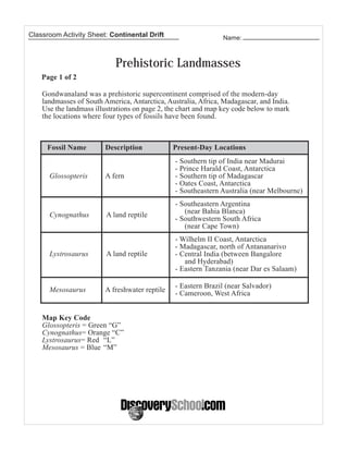
This lesson plan teaches students about continental drift and how scientists developed the theory. Students map the locations of fossils found on different continents to see if the fossil evidence supports the idea that the continents were once joined together in a supercontinent. Students cut out shapes of continents and try arranging them as the supercontinent Gondwanaland. They are assessed on their ability to complete the mapping and reconstruction activities, as well as participate in a discussion about the evidence.


![5G Explained! A High Level Overview [Introduction]](https://cdn.slidesharecdn.com/ss_thumbnails/5gexplainedahighleveloverview-260119165306-cc137a3e-thumbnail.jpg?width=640&height=640&fit=bounds)


