Downloaded 19 times

![Status of joint documents June 2012
(OGC submission to ISO)
• Spatial Referencing by Coordinates [19111] AS Topic Volume 1
• Simple Features 1.1 [ISO 19125-1 and 2]
• OGC Geography Markup Language 3.2.1 [ISO 19136]
• OGC Web Map Service 1.3 [ISO 19128]
• Web Feature Service 2.0 [ISO 19142] and
Filter Encoding 2.0 [ISO 19143]
• Observations and Measurements 1.0 approved as an OGC
Abstract Specification Topic Volume [ISO 19156]
© 2012 Open Geospatial Consortium](https://image.slidesharecdn.com/2012juneogcandiso-13389965778371-phpapp02-120606104847-phpapp02/85/June-2012-_-OGC-and-ISO-10-320.jpg)

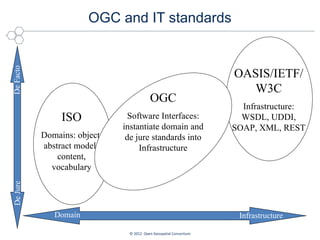
The document discusses the relationship between the Open Geospatial Consortium (OGC) and the International Organization for Standardization (ISO), focusing on their complementary roles in setting IT and geospatial standards. OGC develops voluntary consensus standards that are publicly available, while ISO establishes de jure standards, with both organizations working together to ensure interoperability and communication. Examples of their collaboration include standards for geospatial and temporal data, as well as specific applications like air quality data management.


