Downloaded 28 times
![OpenStreetMapOpenStreetMap (OSM) is dedicated to creating and providing geographic data, such as street maps, worldwide, for free. [1][1] http://wiki.openstreetmap.org/wiki/Press](https://image.slidesharecdn.com/openstreetmap-110917063439-phpapp01/85/OpenStreetMap-Introduction-1-320.jpg)
![OpenStreetMapOpenStreetMap (OSM) is dedicated to creating and providing geographic data, such as street maps, worldwide, for free. [1][1] http://wiki.openstreetmap.org/wiki/Press](https://image.slidesharecdn.com/openstreetmap-110917063439-phpapp01/75/OpenStreetMap-Introduction-1-2048.jpg)
![Contact: p.rieffel@uni-muenster.deOpenStreetMap?OpenStreetMap creates and provides free geographic data such as street maps to anyone who wants them. The project was started because most maps you think of as free actually have legal or technical restrictions on their use, holding back people from using them in creative, productive, or unexpected ways. [1][1] http://wiki.openstreetmap.org/wiki/Main_Page](https://image.slidesharecdn.com/openstreetmap-110917063439-phpapp01/85/OpenStreetMap-Introduction-5-320.jpg)
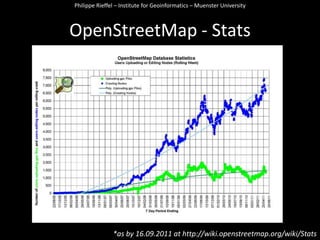
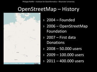

OpenStreetMap (OSM) is a project to create a free editable map of the world by collecting geographic data from users. Users can contribute data like streets, trails, and points of interest collected with GPS devices or digitized from aerial imagery. The data is made available under an open license for anyone to use and is rendered into editable maps through tools like JOSM. Over 400,000 users have contributed data since OSM started in 2004.


