Download to read offline

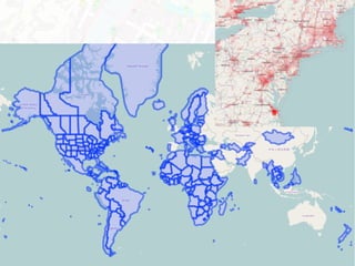

![Sax analyser
class Name_Spaces(Plugin):
def init(self, logger):
self.errors[903] = { "item": 5010, "level": 2, "tag": ["name", "fix:chair"], "desc": T_(u"Too
many spaces") }
def node(self, data, tags):
name = tags[u"name"]
if u" " in name:
err.append({"class": 903, "subclass": 0, "text": T_("Name contains successive
spaces")})
if len(err) > 0:
name = re.sub(r' +', ' ', name.strip())
for e in err:
e["fix"] = {"name": name}
issue definition
issue detection
issue possible fix](https://image.slidesharecdn.com/20150607-sotm-us-osmose-qa-150627121702-lva1-app6891/85/20150607-sotm-us-osmose-qa-12-320.jpg)
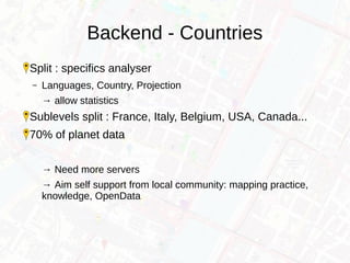
![Osmosis analyserSql10 = """
SELECT
id,
ST_AsText(way_locate(linestring))
FROM
ways
WHERE
tags ? 'junction' AND tags->'junction' = 'roundabout' AND
is_polygon AND ST_IsSimple(linestring) AND
{1} ST_OrderingEquals(ST_Makepolygon(linestring), st_forceRHR(ST_Makepolygon(linestring)))"""
class Analyser_Osmosis_Roundabout_Reverse(Analyser_Osmosis):
def __init__(self, config, logger = None):
Analyser_Osmosis.__init__(self, config, logger)
self.classs_change[1] = {"item":"1050", "level": 1, "tag": ["highway", "roundabout", "fix:chair"], "desc": T_(u"Reverse
roundabout") }
self.callback10 = lambda res: {"class":1, "data":[self.way_full, self.positionAsText]}
if self.config.options.get("driving_side") == "left":
self.driving_side = "NOT "
else:
self.driving_side = ""
def analyser_osmosis_all(self):
self.run(sql10.format("", self.driving_side), self.callback10)
issue detection
issue definition](https://image.slidesharecdn.com/20150607-sotm-us-osmose-qa-150627121702-lva1-app6891/85/20150607-sotm-us-osmose-qa-13-320.jpg)
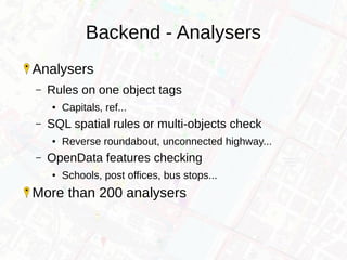
![OpenData analyser
class Analyser_Merge_Poste_FR(Analyser_Merge):
def __init__(self, config, logger = None):
self.missing_official = {"item":"8020", "class": 1, "level": 3, "tag": ["merge", "post"], "desc": T_(u"Post office not integrated") }
self.missing_osm = {"item":"7050", "class": 2, "level": 3, "tag": ["merge", "post"], "desc": T_(u"Post office without ref:FR:LaPoste") }
self.possible_merge = {"item":"8021", "class": 3, "level": 3, "tag": ["merge", "post"], "desc": T_(u"Post office, integration suggestion") }
Analyser_Merge.__init__(self, config, logger,
Source(
name = u"points de contact du réseau postal français",
file = "poste_FR.csv.bz2",
encoding = "ISO-8859-15",
csv = CSV(separator = ";")),
Load("Longitude", "Latitude", table = "poste_fr"),
Mapping(
select = Select(
types = ["nodes", "ways"],
tags = {"amenity": "post_office"}),
osmRef = "ref:FR:LaPoste",
conflationDistance = 1000,
generate = Generate(
static = {
"amenity": "post_office",
"operator": "La Poste",
"source": "data.gouv.fr:LaPoste - 01/2013"},
mapping = {
"ref:FR:LaPoste": "Identifiant",
"name": lambda res: re.sub(self.Principal, " Principal", res[u"Libellé du site"]),
"addr:postcode": "Code postal"} )))
issue definitions
OpenData source file description
OSM data pick-up
Join OpenData & OSM
Map OpenData columns to OSM tags](https://image.slidesharecdn.com/20150607-sotm-us-osmose-qa-150627121702-lva1-app6891/85/20150607-sotm-us-osmose-qa-14-320.jpg)
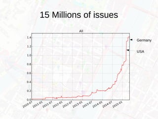

![Maproulette
Bridge to Maproulette
Reports choose:
– [world] Highway intersecting building
– [world] Object tagged twice as node or way
– [france] Missing soccer pitch
– [world] Broken highway level continuity
→ OSM as a Marathon](https://image.slidesharecdn.com/20150607-sotm-us-osmose-qa-150627121702-lva1-app6891/85/20150607-sotm-us-osmose-qa-21-320.jpg)


Osmose QA is a quality assurance tool that analyzes OpenStreetMap data to detect issues using over 200 rules. It provides interactive maps and reports to help identify missing data, errors, and suggest improvements. The tool splits analysis of OpenStreetMap data among over 70 countries and regions to allow for localized knowledge and practices. It also integrates third-party open data sources like postal office locations in France to detect discrepancies between OpenStreetMap and the additional datasets.