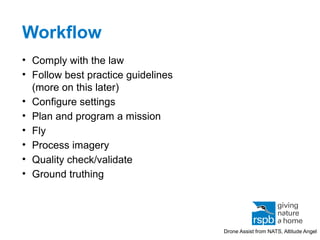
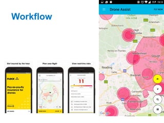
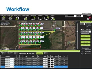
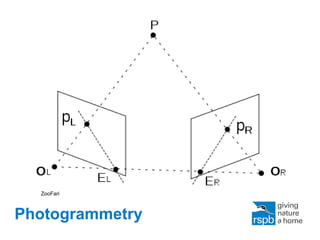
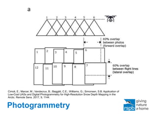
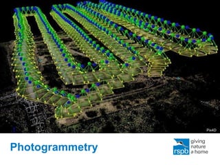
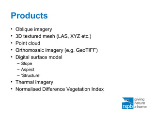
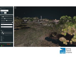
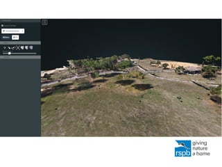
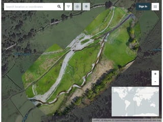
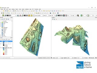
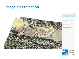
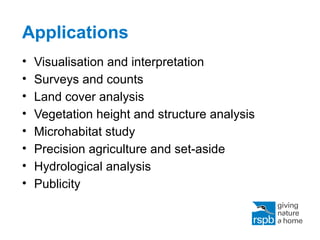
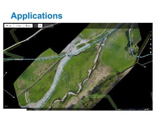
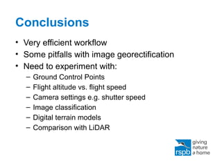
SlideShare a Scribd company logo
Open Drones
A free and open source workflow for the
use of drone imagery in mapping and
geospatial applications
Thomas Starnes @bio_carta
Overview
• Background
• Workflow
• Products
• Applications
• Conclusions
Overview
• Background
• Workflow
• Products
• Applications
• Conclusions
Background
Published by Environment Agency under Open Government Licence
(c) David Morris
Overview
• Background
• Workflow
• Products
• Applications
• Conclusions
Workflow
• Comply with the law
• Follow best practice guidelines
(more on this later)
• Configure settings
• Plan and program a mission
• Fly
• Process imagery
• Quality check/validate
• Ground truthing
Drone Assist from NATS, Altitude Angel
Workflow
Workflow
Mission Planner
Workflow
Workflow
Workflow
Workflow
WebODM Installer
Workflow
Photogrammetry
ZooFari
Photogrammetry
Cimoli, E.; Marcer, M.; Vandecrux, B.; Bøggild, C.E.; Williams, G.; Simonsen, S.B. Application of
Low-Cost UASs and Digital Photogrammetry for High-Resolution Snow Depth Mapping in the
Arctic. Remote Sens. 2017, 9, 1144.
Photogrammetry
Pix4D
Overview
• Background
• Workflow
• Products
• Applications
• Conclusions
Products
• Oblique imagery
• 3D textured mesh (LAS, XYZ etc.)
• Point cloud
• Orthomosaic imagery (e.g. GeoTIFF)
• Digital surface model
– Slope
– Aspect
– ‘Structure’
• Thermal imagery
• Normalised Difference Vegetation Index
Drone orthomosaic vs. aerial imagery
Image classification
Overview
• Background
• Workflow
• Products
• Applications
• Conclusions
Applications
• Visualisation and interpretation
• Surveys and counts
• Land cover analysis
• Vegetation height and structure analysis
• Microhabitat study
• Precision agriculture and set-aside
• Hydrological analysis
• Publicity
Applications
Overview
• Background
• Workflow
• Products
• Applications
• Conclusions
Conclusions
• Very efficient workflow
• Some pitfalls with image georectification
• Need to experiment with:
– Ground Control Points
– Flight altitude vs. flight speed
– Camera settings e.g. shutter speed
– Image classification
– Digital terrain models
– Comparison with LiDAR
Conclusions
https://www.wildlabs.net/sites/default/files/community/files/drones_for_gis_-_best_practice_1.2_0.pdf
Thank you
thomas.starnes@rspb.org
@bio_carta
The RSPB is part of BirdLife International,
a partnership of nature conservation
organisations working to give nature a
home around the world.

More Related Content

What's hot

2017 PLSC Track: Positional Accuracy Comparison of a DII Inspire 1 and a Sens...
2017 PLSC Track: Positional Accuracy Comparison of a DII Inspire 1 and a Sens...2017 PLSC Track: Positional Accuracy Comparison of a DII Inspire 1 and a Sens...
2017 PLSC Track: Positional Accuracy Comparison of a DII Inspire 1 and a Sens...
GIS in the Rockies
 
Kelly, Julia: Thermal cameras: a new tool for modeling and upscaling ecosyste...
Kelly, Julia: Thermal cameras: a new tool for modeling and upscaling ecosyste...Kelly, Julia: Thermal cameras: a new tool for modeling and upscaling ecosyste...
Kelly, Julia: Thermal cameras: a new tool for modeling and upscaling ecosyste...
Integrated Carbon Observation System (ICOS)
 
MODELING DAILY NET SHORTWAVE RADIATION OVER RUGGED SURFACES USING MODIS ATMOS...
MODELING DAILY NET SHORTWAVE RADIATION OVER RUGGED SURFACES USING MODIS ATMOS...MODELING DAILY NET SHORTWAVE RADIATION OVER RUGGED SURFACES USING MODIS ATMOS...
MODELING DAILY NET SHORTWAVE RADIATION OVER RUGGED SURFACES USING MODIS ATMOS...
grssieee
 
Atmos - Tom hartley - Modelling Bird Behaviour to Progress Wind Farm Development
Atmos - Tom hartley - Modelling Bird Behaviour to Progress Wind Farm DevelopmentAtmos - Tom hartley - Modelling Bird Behaviour to Progress Wind Farm Development
Atmos - Tom hartley - Modelling Bird Behaviour to Progress Wind Farm Development
Esri UK
 
Remote sensing and gis
Remote sensing and gisRemote sensing and gis
Remote sensing and gis
NavneetJames
 
Tianjin Case Study
Tianjin Case StudyTianjin Case Study
Tianjin Case Study
VisionMap
 
Android mobile application for geoscientific field study
Android mobile application for geoscientific field studyAndroid mobile application for geoscientific field study
Android mobile application for geoscientific field study
kalai vanan
 
The UAE solar Atlas
The UAE solar AtlasThe UAE solar Atlas
The UAE solar Atlas
IRENA Global Atlas
 
Photogrammetry predicts infrastructure problems before they happen
Photogrammetry predicts infrastructure problems before they happenPhotogrammetry predicts infrastructure problems before they happen
Photogrammetry predicts infrastructure problems before they happen
NI BT
 
A new cloud computing architecture for the classification of remote sensing data
A new cloud computing architecture for the classification of remote sensing dataA new cloud computing architecture for the classification of remote sensing data
A new cloud computing architecture for the classification of remote sensing data
Suhas Shriyan
 
Using deep learning in remote sensing
Using deep learning in remote sensingUsing deep learning in remote sensing
Using deep learning in remote sensing
Mohamed Yousif
 
GPS technology
GPS technologyGPS technology
GPS technology
sheila_lovesnow
 
Lupws session 1 progress NGD FINNMAP_short_oct2012_eng only
Lupws session 1 progress NGD FINNMAP_short_oct2012_eng onlyLupws session 1 progress NGD FINNMAP_short_oct2012_eng only
Lupws session 1 progress NGD FINNMAP_short_oct2012_eng only
LUP_Lao
 
Copernicus and its evolution H2020
Copernicus and its evolution H2020Copernicus and its evolution H2020
Copernicus and its evolution H2020
The European GNSS Agency (GSA)
 
Bluesky - Esri UK Annual Conference 2016
Bluesky - Esri UK Annual Conference 2016Bluesky - Esri UK Annual Conference 2016
Bluesky - Esri UK Annual Conference 2016
Esri UK
 
SFScon 2020 - Stefano Tondini - Low-cost high-res GNSS technology in combinat...
SFScon 2020 - Stefano Tondini - Low-cost high-res GNSS technology in combinat...SFScon 2020 - Stefano Tondini - Low-cost high-res GNSS technology in combinat...
SFScon 2020 - Stefano Tondini - Low-cost high-res GNSS technology in combinat...
South Tyrol Free Software Conference
 
Remote sensing
Remote sensing   Remote sensing
Remote sensing
kalyanabooshnam
 
Remote sensing & Gis
Remote sensing & GisRemote sensing & Gis
Remote sensing & Gis
gopichand's
 
Application of Remote Sensing and GIS in Urban Planning
Application of Remote Sensing and GIS in Urban PlanningApplication of Remote Sensing and GIS in Urban Planning
Application of Remote Sensing and GIS in Urban Planning
KARTHICK KRISHNA
 
The GIS for the Solar Projects Development
The GIS for the Solar Projects DevelopmentThe GIS for the Solar Projects Development
The GIS for the Solar Projects Development
Esri
 

What's hot (20)

2017 PLSC Track: Positional Accuracy Comparison of a DII Inspire 1 and a Sens...
2017 PLSC Track: Positional Accuracy Comparison of a DII Inspire 1 and a Sens...2017 PLSC Track: Positional Accuracy Comparison of a DII Inspire 1 and a Sens...
2017 PLSC Track: Positional Accuracy Comparison of a DII Inspire 1 and a Sens...
 
Kelly, Julia: Thermal cameras: a new tool for modeling and upscaling ecosyste...
Kelly, Julia: Thermal cameras: a new tool for modeling and upscaling ecosyste...Kelly, Julia: Thermal cameras: a new tool for modeling and upscaling ecosyste...
Kelly, Julia: Thermal cameras: a new tool for modeling and upscaling ecosyste...
 
MODELING DAILY NET SHORTWAVE RADIATION OVER RUGGED SURFACES USING MODIS ATMOS...
MODELING DAILY NET SHORTWAVE RADIATION OVER RUGGED SURFACES USING MODIS ATMOS...MODELING DAILY NET SHORTWAVE RADIATION OVER RUGGED SURFACES USING MODIS ATMOS...
MODELING DAILY NET SHORTWAVE RADIATION OVER RUGGED SURFACES USING MODIS ATMOS...
 
Atmos - Tom hartley - Modelling Bird Behaviour to Progress Wind Farm Development
Atmos - Tom hartley - Modelling Bird Behaviour to Progress Wind Farm DevelopmentAtmos - Tom hartley - Modelling Bird Behaviour to Progress Wind Farm Development
Atmos - Tom hartley - Modelling Bird Behaviour to Progress Wind Farm Development
 
Remote sensing and gis
Remote sensing and gisRemote sensing and gis
Remote sensing and gis
 
Tianjin Case Study
Tianjin Case StudyTianjin Case Study
Tianjin Case Study
 
Android mobile application for geoscientific field study
Android mobile application for geoscientific field studyAndroid mobile application for geoscientific field study
Android mobile application for geoscientific field study
 
The UAE solar Atlas
The UAE solar AtlasThe UAE solar Atlas
The UAE solar Atlas
 
Photogrammetry predicts infrastructure problems before they happen
Photogrammetry predicts infrastructure problems before they happenPhotogrammetry predicts infrastructure problems before they happen
Photogrammetry predicts infrastructure problems before they happen
 
A new cloud computing architecture for the classification of remote sensing data
A new cloud computing architecture for the classification of remote sensing dataA new cloud computing architecture for the classification of remote sensing data
A new cloud computing architecture for the classification of remote sensing data
 
Using deep learning in remote sensing
Using deep learning in remote sensingUsing deep learning in remote sensing
Using deep learning in remote sensing
 
GPS technology
GPS technologyGPS technology
GPS technology
 
Lupws session 1 progress NGD FINNMAP_short_oct2012_eng only
Lupws session 1 progress NGD FINNMAP_short_oct2012_eng onlyLupws session 1 progress NGD FINNMAP_short_oct2012_eng only
Lupws session 1 progress NGD FINNMAP_short_oct2012_eng only
 
Copernicus and its evolution H2020
Copernicus and its evolution H2020Copernicus and its evolution H2020
Copernicus and its evolution H2020
 
Bluesky - Esri UK Annual Conference 2016
Bluesky - Esri UK Annual Conference 2016Bluesky - Esri UK Annual Conference 2016
Bluesky - Esri UK Annual Conference 2016
 
SFScon 2020 - Stefano Tondini - Low-cost high-res GNSS technology in combinat...
SFScon 2020 - Stefano Tondini - Low-cost high-res GNSS technology in combinat...SFScon 2020 - Stefano Tondini - Low-cost high-res GNSS technology in combinat...
SFScon 2020 - Stefano Tondini - Low-cost high-res GNSS technology in combinat...
 
Remote sensing
Remote sensing   Remote sensing
Remote sensing
 
Remote sensing & Gis
Remote sensing & GisRemote sensing & Gis
Remote sensing & Gis
 
Application of Remote Sensing and GIS in Urban Planning
Application of Remote Sensing and GIS in Urban PlanningApplication of Remote Sensing and GIS in Urban Planning
Application of Remote Sensing and GIS in Urban Planning
 
The GIS for the Solar Projects Development
The GIS for the Solar Projects DevelopmentThe GIS for the Solar Projects Development
The GIS for the Solar Projects Development
 

Similar to Open drones

MineExcellence - drones platform for mining industry
MineExcellence - drones platform for mining industryMineExcellence - drones platform for mining industry
MineExcellence - drones platform for mining industry
Mason Taylor
 
Assessing soil erosion with unmanned aeria vehicles
Assessing soil erosion with unmanned aeria vehiclesAssessing soil erosion with unmanned aeria vehicles
Assessing soil erosion with unmanned aeria vehicles
Soil and Water Conservation Society
 
ScanMapBrochure2016_loRES
ScanMapBrochure2016_loRESScanMapBrochure2016_loRES
ScanMapBrochure2016_loRES
John Taylor
 
How unmanned aerial vehicles can help manage my construction?
How unmanned aerial vehicles can help manage my construction?How unmanned aerial vehicles can help manage my construction?
How unmanned aerial vehicles can help manage my construction?
Cascadian Aerial Robotics LLC
 
SU Business Expo-2015 - Jonathan Downey
SU Business Expo-2015 - Jonathan Downey SU Business Expo-2015 - Jonathan Downey
SU Business Expo-2015 - Jonathan Downey
sUAS News
 
Poster: Enhancing and Educating with the WxSat Mobile App
Poster: Enhancing and Educating with the WxSat Mobile AppPoster: Enhancing and Educating with the WxSat Mobile App
Poster: Enhancing and Educating with the WxSat Mobile App
Kyle Nelson
 
Le Bourget 2017 - From earth observation to actionable intelligence
Le Bourget 2017 - From earth observation to actionable intelligenceLe Bourget 2017 - From earth observation to actionable intelligence
Le Bourget 2017 - From earth observation to actionable intelligence
Leonardo
 
UAVmapping_11111.ppt
UAVmapping_11111.pptUAVmapping_11111.ppt
UAVmapping_11111.ppt
BismaJZ
 
Caldwell uas
Caldwell uasCaldwell uas
Caldwell uas
GeCo in the Rockies
 
Juniper Unmanned AU Presentation
Juniper Unmanned AU PresentationJuniper Unmanned AU Presentation
Juniper Unmanned AU Presentation
Jeff Cozart
 
Ipso facto drones an invaluable project management tool
Ipso facto drones   an invaluable project management toolIpso facto drones   an invaluable project management tool
Ipso facto drones an invaluable project management tool
Association for Project Management
 
DSM Extraction from Pleiades Images using MICMAC
DSM Extraction from Pleiades Images using MICMAC DSM Extraction from Pleiades Images using MICMAC
DSM Extraction from Pleiades Images using MICMAC
National Cheng Kung University
 
2019 Locate19 OGC Symposia
2019 Locate19 OGC Symposia2019 Locate19 OGC Symposia
2019 Locate19 OGC Symposia
PLACE
 
Sutapa_resume
Sutapa_resumeSutapa_resume
Sutapa_resume
Sutapa Paul
 
5 Remarkable Benefits of Using Drone Surveying and Mapping
5 Remarkable Benefits of Using Drone Surveying and Mapping5 Remarkable Benefits of Using Drone Surveying and Mapping
5 Remarkable Benefits of Using Drone Surveying and Mapping
Eye-bot
 
Using Existing Technology to be More Productive in Construction
Using Existing Technology to be More Productive in ConstructionUsing Existing Technology to be More Productive in Construction
Using Existing Technology to be More Productive in Construction
Bridgit
 
Commercial Drone Best Practices: How to Incorporate Data and Job Specs
Commercial Drone Best Practices: How to Incorporate Data and Job SpecsCommercial Drone Best Practices: How to Incorporate Data and Job Specs
Commercial Drone Best Practices: How to Incorporate Data and Job Specs
Colin Snow
 
UAS Applications for Civil Engineering
UAS Applications for Civil EngineeringUAS Applications for Civil Engineering
UAS Applications for Civil Engineering
UAS Colorado
 
Maps Across Texas
Maps Across TexasMaps Across Texas
bro_geoslam-introduction.pdf
bro_geoslam-introduction.pdfbro_geoslam-introduction.pdf
bro_geoslam-introduction.pdf
YoussefZghari
 

Similar to Open drones (20)

MineExcellence - drones platform for mining industry
MineExcellence - drones platform for mining industryMineExcellence - drones platform for mining industry
MineExcellence - drones platform for mining industry
 
Assessing soil erosion with unmanned aeria vehicles
Assessing soil erosion with unmanned aeria vehiclesAssessing soil erosion with unmanned aeria vehicles
Assessing soil erosion with unmanned aeria vehicles
 
ScanMapBrochure2016_loRES
ScanMapBrochure2016_loRESScanMapBrochure2016_loRES
ScanMapBrochure2016_loRES
 
How unmanned aerial vehicles can help manage my construction?
How unmanned aerial vehicles can help manage my construction?How unmanned aerial vehicles can help manage my construction?
How unmanned aerial vehicles can help manage my construction?
 
SU Business Expo-2015 - Jonathan Downey
SU Business Expo-2015 - Jonathan Downey SU Business Expo-2015 - Jonathan Downey
SU Business Expo-2015 - Jonathan Downey
 
Poster: Enhancing and Educating with the WxSat Mobile App
Poster: Enhancing and Educating with the WxSat Mobile AppPoster: Enhancing and Educating with the WxSat Mobile App
Poster: Enhancing and Educating with the WxSat Mobile App
 
Le Bourget 2017 - From earth observation to actionable intelligence
Le Bourget 2017 - From earth observation to actionable intelligenceLe Bourget 2017 - From earth observation to actionable intelligence
Le Bourget 2017 - From earth observation to actionable intelligence
 
UAVmapping_11111.ppt
UAVmapping_11111.pptUAVmapping_11111.ppt
UAVmapping_11111.ppt
 
Caldwell uas
Caldwell uasCaldwell uas
Caldwell uas
 
Juniper Unmanned AU Presentation
Juniper Unmanned AU PresentationJuniper Unmanned AU Presentation
Juniper Unmanned AU Presentation
 
Ipso facto drones an invaluable project management tool
Ipso facto drones   an invaluable project management toolIpso facto drones   an invaluable project management tool
Ipso facto drones an invaluable project management tool
 
DSM Extraction from Pleiades Images using MICMAC
DSM Extraction from Pleiades Images using MICMAC DSM Extraction from Pleiades Images using MICMAC
DSM Extraction from Pleiades Images using MICMAC
 
2019 Locate19 OGC Symposia
2019 Locate19 OGC Symposia2019 Locate19 OGC Symposia
2019 Locate19 OGC Symposia
 
Sutapa_resume
Sutapa_resumeSutapa_resume
Sutapa_resume
 
5 Remarkable Benefits of Using Drone Surveying and Mapping
5 Remarkable Benefits of Using Drone Surveying and Mapping5 Remarkable Benefits of Using Drone Surveying and Mapping
5 Remarkable Benefits of Using Drone Surveying and Mapping
 
Using Existing Technology to be More Productive in Construction
Using Existing Technology to be More Productive in ConstructionUsing Existing Technology to be More Productive in Construction
Using Existing Technology to be More Productive in Construction
 
Commercial Drone Best Practices: How to Incorporate Data and Job Specs
Commercial Drone Best Practices: How to Incorporate Data and Job SpecsCommercial Drone Best Practices: How to Incorporate Data and Job Specs
Commercial Drone Best Practices: How to Incorporate Data and Job Specs
 
UAS Applications for Civil Engineering
UAS Applications for Civil EngineeringUAS Applications for Civil Engineering
UAS Applications for Civil Engineering
 
Maps Across Texas
Maps Across TexasMaps Across Texas
Maps Across Texas
 
bro_geoslam-introduction.pdf
bro_geoslam-introduction.pdfbro_geoslam-introduction.pdf
bro_geoslam-introduction.pdf
 

Recently uploaded

5th LF Energy Power Grid Model Meet-up Slides
5th LF Energy Power Grid Model Meet-up Slides5th LF Energy Power Grid Model Meet-up Slides
5th LF Energy Power Grid Model Meet-up Slides
DanBrown980551
 
Skybuffer SAM4U tool for SAP license adoption
Skybuffer SAM4U tool for SAP license adoptionSkybuffer SAM4U tool for SAP license adoption
Skybuffer SAM4U tool for SAP license adoption
Tatiana Kojar
 
UI5 Controls simplified - UI5con2024 presentation
UI5 Controls simplified - UI5con2024 presentationUI5 Controls simplified - UI5con2024 presentation
UI5 Controls simplified - UI5con2024 presentation
Wouter Lemaire
 
How to Interpret Trends in the Kalyan Rajdhani Mix Chart.pdf
How to Interpret Trends in the Kalyan Rajdhani Mix Chart.pdfHow to Interpret Trends in the Kalyan Rajdhani Mix Chart.pdf
How to Interpret Trends in the Kalyan Rajdhani Mix Chart.pdf
Chart Kalyan
 
Driving Business Innovation: Latest Generative AI Advancements & Success Story
Driving Business Innovation: Latest Generative AI Advancements & Success StoryDriving Business Innovation: Latest Generative AI Advancements & Success Story
Driving Business Innovation: Latest Generative AI Advancements & Success Story
Safe Software
 
Mariano G Tinti - Decoding SpaceX
Mariano G Tinti - Decoding SpaceXMariano G Tinti - Decoding SpaceX
Mariano G Tinti - Decoding SpaceX
Mariano Tinti
 
Generating privacy-protected synthetic data using Secludy and Milvus
Generating privacy-protected synthetic data using Secludy and MilvusGenerating privacy-protected synthetic data using Secludy and Milvus
Generating privacy-protected synthetic data using Secludy and Milvus
Zilliz
 
“Building and Scaling AI Applications with the Nx AI Manager,” a Presentation...
“Building and Scaling AI Applications with the Nx AI Manager,” a Presentation...“Building and Scaling AI Applications with the Nx AI Manager,” a Presentation...
“Building and Scaling AI Applications with the Nx AI Manager,” a Presentation...
Edge AI and Vision Alliance
 
HCL Notes und Domino Lizenzkostenreduzierung in der Welt von DLAU
HCL Notes und Domino Lizenzkostenreduzierung in der Welt von DLAUHCL Notes und Domino Lizenzkostenreduzierung in der Welt von DLAU
HCL Notes und Domino Lizenzkostenreduzierung in der Welt von DLAU
panagenda
 
Fueling AI with Great Data with Airbyte Webinar
Fueling AI with Great Data with Airbyte WebinarFueling AI with Great Data with Airbyte Webinar
Fueling AI with Great Data with Airbyte Webinar
Zilliz
 
Energy Efficient Video Encoding for Cloud and Edge Computing Instances
Energy Efficient Video Encoding for Cloud and Edge Computing InstancesEnergy Efficient Video Encoding for Cloud and Edge Computing Instances
Energy Efficient Video Encoding for Cloud and Edge Computing Instances
Alpen-Adria-Universität
 
20240607 QFM018 Elixir Reading List May 2024
20240607 QFM018 Elixir Reading List May 202420240607 QFM018 Elixir Reading List May 2024
20240607 QFM018 Elixir Reading List May 2024
Matthew Sinclair
 
Columbus Data & Analytics Wednesdays - June 2024
Columbus Data & Analytics Wednesdays - June 2024Columbus Data & Analytics Wednesdays - June 2024
Columbus Data & Analytics Wednesdays - June 2024
Jason Packer
 
Digital Marketing Trends in 2024 | Guide for Staying Ahead
Digital Marketing Trends in 2024 | Guide for Staying AheadDigital Marketing Trends in 2024 | Guide for Staying Ahead
Digital Marketing Trends in 2024 | Guide for Staying Ahead
Wask
 
Salesforce Integration for Bonterra Impact Management (fka Social Solutions A...
Salesforce Integration for Bonterra Impact Management (fka Social Solutions A...Salesforce Integration for Bonterra Impact Management (fka Social Solutions A...
Salesforce Integration for Bonterra Impact Management (fka Social Solutions A...
Jeffrey Haguewood
 
UiPath Test Automation using UiPath Test Suite series, part 6
UiPath Test Automation using UiPath Test Suite series, part 6UiPath Test Automation using UiPath Test Suite series, part 6
UiPath Test Automation using UiPath Test Suite series, part 6
DianaGray10
 
Artificial Intelligence for XMLDevelopment
Artificial Intelligence for XMLDevelopmentArtificial Intelligence for XMLDevelopment
Artificial Intelligence for XMLDevelopment
Octavian Nadolu
 
Choosing The Best AWS Service For Your Website + API.pptx
Choosing The Best AWS Service For Your Website + API.pptxChoosing The Best AWS Service For Your Website + API.pptx
Choosing The Best AWS Service For Your Website + API.pptx
Brandon Minnick, MBA
 
OpenID AuthZEN Interop Read Out - Authorization
OpenID AuthZEN Interop Read Out - AuthorizationOpenID AuthZEN Interop Read Out - Authorization
OpenID AuthZEN Interop Read Out - Authorization
David Brossard
 
Deep Dive: AI-Powered Marketing to Get More Leads and Customers with HyperGro...
Deep Dive: AI-Powered Marketing to Get More Leads and Customers with HyperGro...Deep Dive: AI-Powered Marketing to Get More Leads and Customers with HyperGro...
Deep Dive: AI-Powered Marketing to Get More Leads and Customers with HyperGro...
saastr
 

Recently uploaded (20)

5th LF Energy Power Grid Model Meet-up Slides
5th LF Energy Power Grid Model Meet-up Slides5th LF Energy Power Grid Model Meet-up Slides
5th LF Energy Power Grid Model Meet-up Slides
 
Skybuffer SAM4U tool for SAP license adoption
Skybuffer SAM4U tool for SAP license adoptionSkybuffer SAM4U tool for SAP license adoption
Skybuffer SAM4U tool for SAP license adoption
 
UI5 Controls simplified - UI5con2024 presentation
UI5 Controls simplified - UI5con2024 presentationUI5 Controls simplified - UI5con2024 presentation
UI5 Controls simplified - UI5con2024 presentation
 
How to Interpret Trends in the Kalyan Rajdhani Mix Chart.pdf
How to Interpret Trends in the Kalyan Rajdhani Mix Chart.pdfHow to Interpret Trends in the Kalyan Rajdhani Mix Chart.pdf
How to Interpret Trends in the Kalyan Rajdhani Mix Chart.pdf
 
Driving Business Innovation: Latest Generative AI Advancements & Success Story
Driving Business Innovation: Latest Generative AI Advancements & Success StoryDriving Business Innovation: Latest Generative AI Advancements & Success Story
Driving Business Innovation: Latest Generative AI Advancements & Success Story
 
Mariano G Tinti - Decoding SpaceX
Mariano G Tinti - Decoding SpaceXMariano G Tinti - Decoding SpaceX
Mariano G Tinti - Decoding SpaceX
 
Generating privacy-protected synthetic data using Secludy and Milvus
Generating privacy-protected synthetic data using Secludy and MilvusGenerating privacy-protected synthetic data using Secludy and Milvus
Generating privacy-protected synthetic data using Secludy and Milvus
 
“Building and Scaling AI Applications with the Nx AI Manager,” a Presentation...
“Building and Scaling AI Applications with the Nx AI Manager,” a Presentation...“Building and Scaling AI Applications with the Nx AI Manager,” a Presentation...
“Building and Scaling AI Applications with the Nx AI Manager,” a Presentation...
 
HCL Notes und Domino Lizenzkostenreduzierung in der Welt von DLAU
HCL Notes und Domino Lizenzkostenreduzierung in der Welt von DLAUHCL Notes und Domino Lizenzkostenreduzierung in der Welt von DLAU
HCL Notes und Domino Lizenzkostenreduzierung in der Welt von DLAU
 
Fueling AI with Great Data with Airbyte Webinar
Fueling AI with Great Data with Airbyte WebinarFueling AI with Great Data with Airbyte Webinar
Fueling AI with Great Data with Airbyte Webinar
 
Energy Efficient Video Encoding for Cloud and Edge Computing Instances
Energy Efficient Video Encoding for Cloud and Edge Computing InstancesEnergy Efficient Video Encoding for Cloud and Edge Computing Instances
Energy Efficient Video Encoding for Cloud and Edge Computing Instances
 
20240607 QFM018 Elixir Reading List May 2024
20240607 QFM018 Elixir Reading List May 202420240607 QFM018 Elixir Reading List May 2024
20240607 QFM018 Elixir Reading List May 2024
 
Columbus Data & Analytics Wednesdays - June 2024
Columbus Data & Analytics Wednesdays - June 2024Columbus Data & Analytics Wednesdays - June 2024
Columbus Data & Analytics Wednesdays - June 2024
 
Digital Marketing Trends in 2024 | Guide for Staying Ahead
Digital Marketing Trends in 2024 | Guide for Staying AheadDigital Marketing Trends in 2024 | Guide for Staying Ahead
Digital Marketing Trends in 2024 | Guide for Staying Ahead
 
Salesforce Integration for Bonterra Impact Management (fka Social Solutions A...
Salesforce Integration for Bonterra Impact Management (fka Social Solutions A...Salesforce Integration for Bonterra Impact Management (fka Social Solutions A...
Salesforce Integration for Bonterra Impact Management (fka Social Solutions A...
 
UiPath Test Automation using UiPath Test Suite series, part 6
UiPath Test Automation using UiPath Test Suite series, part 6UiPath Test Automation using UiPath Test Suite series, part 6
UiPath Test Automation using UiPath Test Suite series, part 6
 
Artificial Intelligence for XMLDevelopment
Artificial Intelligence for XMLDevelopmentArtificial Intelligence for XMLDevelopment
Artificial Intelligence for XMLDevelopment
 
Choosing The Best AWS Service For Your Website + API.pptx
Choosing The Best AWS Service For Your Website + API.pptxChoosing The Best AWS Service For Your Website + API.pptx
Choosing The Best AWS Service For Your Website + API.pptx
 
OpenID AuthZEN Interop Read Out - Authorization
OpenID AuthZEN Interop Read Out - AuthorizationOpenID AuthZEN Interop Read Out - Authorization
OpenID AuthZEN Interop Read Out - Authorization
 
Deep Dive: AI-Powered Marketing to Get More Leads and Customers with HyperGro...
Deep Dive: AI-Powered Marketing to Get More Leads and Customers with HyperGro...Deep Dive: AI-Powered Marketing to Get More Leads and Customers with HyperGro...
Deep Dive: AI-Powered Marketing to Get More Leads and Customers with HyperGro...
 

Open drones

Editor's Notes

  1. Title slide Full picture, black strapline. Note: if the strapline doesn’t standout against your picture, try the title slide that has the logo with white strapline. Failing that, select an alternative picture. <number>
  2. Body slide Logo only on white <number>
  3. Body slide Logo only on white <number>
  4. Body slide Logo only on white <number>
  5. Body slide Logo only on white <number>
  6. Body slide Logo only on white <number>
  7. Body slide Logo only on white <number>
  8. Body slide Logo only on white <number>
  9. Body slide Logo only on white <number>
  10. Body slide Logo only on white <number>
  11. Body slide Logo only on white <number>
  12. Body slide Logo only on white <number>
  13. Body slide Logo only on white <number>
  14. Body slide Logo only on white <number>
  15. Body slide Logo only on white <number>
  16. Body slide Logo only on white <number>
  17. Body slide Logo only on white <number>
  18. Body slide Logo only on white <number>
  19. Body slide Logo only on white <number>
  20. Body slide Logo only on white <number>
  21. Body slide Logo only on white <number>
  22. Body slide Logo only on white <number>
  23. Body slide Logo only on white <number>
  24. Body slide Logo only on white <number>
  25. Body slide Logo only on white <number>
  26. Body slide Logo only on white <number>
  27. Body slide Logo only on white <number>
  28. Body slide Logo only on white <number>
  29. End slide Logo and short describer on white with BirdLife logo and describer. <number>